
Weather in 2006
Encyclopedia
The weather
in 2006 meant another year of extremes. The summer was very hot and dry in the Northern Hemisphere
. Several regions experienced disastrous flood
s, but drought
s were not avoided either. Hurricanes
were easier to Northern America
than the previous year (see 2005 Atlantic hurricane season
), but in the Northwestern Pacific Ocean
, typhoons
were more powerful and frequent than normally.
| |}>
struck the town of Saroma, Hokkaido
in Japan
, killing nine people and injuring 26. It was the most deadly tornado to strike Japan since the beginning of records.
, and moved west toward the Philippines
. On 27 November it became a severe tropical storm. The storm continued to intensify while approaching the islands, and after 30 November the typhoon made several landfalls on different islands of the Philippines, causing over 1200 deaths. The storm then continued its path to the South China Sea
, heading eventually towards southern Vietnam
, where it made a landfall on 5 December. The storm weakened into a tropical depression which crossed the Gulf of Thailand
and southern Thailand
before finally dissipating over the Gulf of Bengal.
, beginning on December 18. For instance, on December 20, a 24-hour rainfall of 366mm was recorded in Singapore
. The resulting floods in those areas have been described as the worst in a century by local officials. Later the same week the torrential rains moved to northern parts of Indonesia
, bringing along severe floods.
As of January 2007, hundreds of thousands of people are displaced by the floods in the areas affected, and casualties number in hundreds. Food shortages and looting continue to sever the infrastructures.
----
experiences highly variable rainfall affected by the El Niño-Southern Oscillation
. Starting 2003, a long period of drought started, described as the worst in a 1,000 years by Australian water specialists.
The situation worsened further in 2006 as the spring rains failed. In the state of South Australia
, rainfall was the lowest since 1900. Average temperatures across the continent, as well, were highest since the 1950s. The situation has prompted new measures of water resources
management in several Australian states.
----
moved from Russia
(where temperatures below -40 °C were recorded) to Central Europe
, many parts of Central, Eastern
and Southern Europe
experienced temperatures well below normal, and there was snow in the Mediterranean region where it is rare; Algiers
in Algeria
and Lisbon
, Portugal
received their first snow in decades. There were estimated 200 deaths attributed to the freezing cold in Europe.
arrived in Central
and Western Europe
, continuing into the summer. July 2006 was the warmest month since the beginning of measurements in several European countries. In Paris
, for instance, temperatures exceeded 40 °C. Mortality during the hot months was higher than normal among the elderly and others vulnerable to high temperatures. The warm, dry summer was followed in Europe by a warm, but windy and rainy autumn, caused by the warming of Northern Atlantic Ocean
during the summer.
----
circulated moist, hot air over the Mid-Atlantic states, which, combined with a stalled jet stream
, started pouring rains over the Mid-Atlantic States
, resulting in rivers and other bodies of water overflowing. According to officials, the event was of a magnitude normally expected once in 200 years.
The floods claimed at least 16 fatalities and caused approximately $1 billion in damages.
and Canada
. It lasted until 27 August in different parts of the countries. In California
, in particular, many records were broken, the state experiencing higher temperatures for longer periods of time than ever before. On July 22, a temperature of 119 °F / 49 °C was recorded in Woodland Hills
in Los Angeles County
. At least 225 deaths have been attributed to the heat wave. Also, it is considered to have played a part in many incidents that increased in frequency or severity during the heat wave, such as forest fires, ruptured water lines, buckled roads, thunderstorm
s and blackout
s in the power grid.
, the 2006 season was relatively quiet in the Northern Atlantic Ocean
. There were 10 storms, of which two major ones (category 3 or more on the Saffir-Simpson Hurricane Scale
), compared to 28 storms with 7 major ones in 2005. No hurricanes made landfall in the United States
.
In the Northwestern Pacific Ocean
, however, the season was busy. 23 tropical storms formed officially, of which 15 attained the status of a typhoon. 7 of them, moreover, reached an intensity that allowed them to be called super typhoons (intensity equal to or higher than 4 on the Saffir-Simpson Hurricane Scale). The high-speed winds, torrential rains and resulting floods caused thousands of fatalities and damage to infrastructure and economy.
Weather
Weather is the state of the atmosphere, to the degree that it is hot or cold, wet or dry, calm or stormy, clear or cloudy. Most weather phenomena occur in the troposphere, just below the stratosphere. Weather refers, generally, to day-to-day temperature and precipitation activity, whereas climate...
in 2006 meant another year of extremes. The summer was very hot and dry in the Northern Hemisphere
Northern Hemisphere
The Northern Hemisphere is the half of a planet that is north of its equator—the word hemisphere literally means “half sphere”. It is also that half of the celestial sphere north of the celestial equator...
. Several regions experienced disastrous flood
Flood
A flood is an overflow of an expanse of water that submerges land. The EU Floods directive defines a flood as a temporary covering by water of land not normally covered by water...
s, but drought
Drought
A drought is an extended period of months or years when a region notes a deficiency in its water supply. Generally, this occurs when a region receives consistently below average precipitation. It can have a substantial impact on the ecosystem and agriculture of the affected region...
s were not avoided either. Hurricanes
2006 Atlantic hurricane season
The 2006 Atlantic hurricane season was significantly less active than the record previous season. It marked the first since 2001 in which no hurricanes made landfall in the United States, and was the first since 1994 that no tropical cyclones formed during October. Following the intense activity of...
were easier to Northern America
Northern America
Northern America is the northernmost region of the Americas, and is part of the North American continent. It lies directly north of the region of Middle America; the land border between the two regions coincides with the border between the United States and Mexico...
than the previous year (see 2005 Atlantic hurricane season
2005 Atlantic hurricane season
The 2005 Atlantic hurricane season was the most active Atlantic hurricane season in recorded history, repeatedly shattering numerous records. The impact of the season was widespread and ruinous with an estimated 3,913 deaths and record damage of about $159.2 billion...
), but in the Northwestern Pacific Ocean
Pacific Ocean
The Pacific Ocean is the largest of the Earth's oceanic divisions. It extends from the Arctic in the north to the Southern Ocean in the south, bounded by Asia and Australia in the west, and the Americas in the east.At 165.2 million square kilometres in area, this largest division of the World...
, typhoons
2006 Pacific typhoon season
The 2006 Pacific typhoon season had no official bounds; it ran year-round in 2006, but most tropical cyclones tend to form in the northwestern Pacific Ocean between May and November...
were more powerful and frequent than normally.
Saroma tornado
On 7 November, a powerful tornadoTornado
A tornado is a violent, dangerous, rotating column of air that is in contact with both the surface of the earth and a cumulonimbus cloud or, in rare cases, the base of a cumulus cloud. They are often referred to as a twister or a cyclone, although the word cyclone is used in meteorology in a wider...
struck the town of Saroma, Hokkaido
Saroma, Hokkaido
is a town in the Tokoro District, Okhotsk Subprefecture, Hokkaido, Japan.The name comes from the Ainu place name saro oma pet, meaning place of many miscanthus reeds.:...
in Japan
Japan
Japan is an island nation in East Asia. Located in the Pacific Ocean, it lies to the east of the Sea of Japan, China, North Korea, South Korea and Russia, stretching from the Sea of Okhotsk in the north to the East China Sea and Taiwan in the south...
, killing nine people and injuring 26. It was the most deadly tornado to strike Japan since the beginning of records.
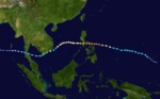
Typhoon Durian (Reming)
A tropical storm formed on 24 November over North Pacific OceanPacific Ocean
The Pacific Ocean is the largest of the Earth's oceanic divisions. It extends from the Arctic in the north to the Southern Ocean in the south, bounded by Asia and Australia in the west, and the Americas in the east.At 165.2 million square kilometres in area, this largest division of the World...
, and moved west toward the Philippines
Philippines
The Philippines , officially known as the Republic of the Philippines , is a country in Southeast Asia in the western Pacific Ocean. To its north across the Luzon Strait lies Taiwan. West across the South China Sea sits Vietnam...
. On 27 November it became a severe tropical storm. The storm continued to intensify while approaching the islands, and after 30 November the typhoon made several landfalls on different islands of the Philippines, causing over 1200 deaths. The storm then continued its path to the South China Sea
South China Sea
The South China Sea is a marginal sea that is part of the Pacific Ocean, encompassing an area from the Singapore and Malacca Straits to the Strait of Taiwan of around...
, heading eventually towards southern Vietnam
Vietnam
Vietnam – sometimes spelled Viet Nam , officially the Socialist Republic of Vietnam – is the easternmost country on the Indochina Peninsula in Southeast Asia. It is bordered by China to the north, Laos to the northwest, Cambodia to the southwest, and the South China Sea –...
, where it made a landfall on 5 December. The storm weakened into a tropical depression which crossed the Gulf of Thailand
Gulf of Thailand
The Gulf of Thailand , also known in to Malays as Teluk Siam literally meant Gulf of Siam, is a shallow arm of the South China Sea.-Geography:...
and southern Thailand
Thailand
Thailand , officially the Kingdom of Thailand , formerly known as Siam , is a country located at the centre of the Indochina peninsula and Southeast Asia. It is bordered to the north by Burma and Laos, to the east by Laos and Cambodia, to the south by the Gulf of Thailand and Malaysia, and to the...
before finally dissipating over the Gulf of Bengal.
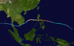
Southeast Asia floods
The Typhoon Utor that crossed the Philippines on December 9, started a period of abnormally high rainfall in the southern provinces of Malaysia and in SingaporeSingapore
Singapore , officially the Republic of Singapore, is a Southeast Asian city-state off the southern tip of the Malay Peninsula, north of the equator. An island country made up of 63 islands, it is separated from Malaysia by the Straits of Johor to its north and from Indonesia's Riau Islands by the...
, beginning on December 18. For instance, on December 20, a 24-hour rainfall of 366mm was recorded in Singapore
Singapore
Singapore , officially the Republic of Singapore, is a Southeast Asian city-state off the southern tip of the Malay Peninsula, north of the equator. An island country made up of 63 islands, it is separated from Malaysia by the Straits of Johor to its north and from Indonesia's Riau Islands by the...
. The resulting floods in those areas have been described as the worst in a century by local officials. Later the same week the torrential rains moved to northern parts of Indonesia
Indonesia
Indonesia , officially the Republic of Indonesia , is a country in Southeast Asia and Oceania. Indonesia is an archipelago comprising approximately 13,000 islands. It has 33 provinces with over 238 million people, and is the world's fourth most populous country. Indonesia is a republic, with an...
, bringing along severe floods.
As of January 2007, hundreds of thousands of people are displaced by the floods in the areas affected, and casualties number in hundreds. Food shortages and looting continue to sever the infrastructures.
----
2006 Australia drought
The continent of AustraliaAustralia
Australia , officially the Commonwealth of Australia, is a country in the Southern Hemisphere comprising the mainland of the Australian continent, the island of Tasmania, and numerous smaller islands in the Indian and Pacific Oceans. It is the world's sixth-largest country by total area...
experiences highly variable rainfall affected by the El Niño-Southern Oscillation
El Niño-Southern Oscillation
El Niño/La Niña-Southern Oscillation, or ENSO, is a quasiperiodic climate pattern that occurs across the tropical Pacific Ocean roughly every five years...
. Starting 2003, a long period of drought started, described as the worst in a 1,000 years by Australian water specialists.
The situation worsened further in 2006 as the spring rains failed. In the state of South Australia
South Australia
South Australia is a state of Australia in the southern central part of the country. It covers some of the most arid parts of the continent; with a total land area of , it is the fourth largest of Australia's six states and two territories.South Australia shares borders with all of the mainland...
, rainfall was the lowest since 1900. Average temperatures across the continent, as well, were highest since the 1950s. The situation has prompted new measures of water resources
Water resources
Water resources are sources of water that are useful or potentially useful. Uses of water include agricultural, industrial, household, recreational and environmental activities. Virtually all of these human uses require fresh water....
management in several Australian states.
----
2006 European cold wave
As a winter cold anticycloneAnticyclone
An anticyclone is a weather phenomenon defined by the United States' National Weather Service's glossary as "[a] large-scale circulation of winds around a central region of high atmospheric pressure, clockwise in the Northern Hemisphere, counterclockwise in the Southern Hemisphere"...
moved from Russia
Russia
Russia or , officially known as both Russia and the Russian Federation , is a country in northern Eurasia. It is a federal semi-presidential republic, comprising 83 federal subjects...
(where temperatures below -40 °C were recorded) to Central Europe
Central Europe
Central Europe or alternatively Middle Europe is a region of the European continent lying between the variously defined areas of Eastern and Western Europe...
, many parts of Central, Eastern
Eastern Europe
Eastern Europe is the eastern part of Europe. The term has widely disparate geopolitical, geographical, cultural and socioeconomic readings, which makes it highly context-dependent and even volatile, and there are "almost as many definitions of Eastern Europe as there are scholars of the region"...
and Southern Europe
Southern Europe
The term Southern Europe, at its most general definition, is used to mean "all countries in the south of Europe". However, the concept, at different times, has had different meanings, providing additional political, linguistic and cultural context to the definition in addition to the typical...
experienced temperatures well below normal, and there was snow in the Mediterranean region where it is rare; Algiers
Algiers
' is the capital and largest city of Algeria. According to the 1998 census, the population of the city proper was 1,519,570 and that of the urban agglomeration was 2,135,630. In 2009, the population was about 3,500,000...
in Algeria
Algeria
Algeria , officially the People's Democratic Republic of Algeria , also formally referred to as the Democratic and Popular Republic of Algeria, is a country in the Maghreb region of Northwest Africa with Algiers as its capital.In terms of land area, it is the largest country in Africa and the Arab...
and Lisbon
Lisbon
Lisbon is the capital city and largest city of Portugal with a population of 545,245 within its administrative limits on a land area of . The urban area of Lisbon extends beyond the administrative city limits with a population of 3 million on an area of , making it the 9th most populous urban...
, Portugal
Portugal
Portugal , officially the Portuguese Republic is a country situated in southwestern Europe on the Iberian Peninsula. Portugal is the westernmost country of Europe, and is bordered by the Atlantic Ocean to the West and South and by Spain to the North and East. The Atlantic archipelagos of the...
received their first snow in decades. There were estimated 200 deaths attributed to the freezing cold in Europe.
2006 European heat wave
At the end of June 2006 a heat waveHeat wave
A heat wave is a prolonged period of excessively hot weather, which may be accompanied by high humidity. There is no universal definition of a heat wave; the term is relative to the usual weather in the area...
arrived in Central
Central Europe
Central Europe or alternatively Middle Europe is a region of the European continent lying between the variously defined areas of Eastern and Western Europe...
and Western Europe
Western Europe
Western Europe is a loose term for the collection of countries in the western most region of the European continents, though this definition is context-dependent and carries cultural and political connotations. One definition describes Western Europe as a geographic entity—the region lying in the...
, continuing into the summer. July 2006 was the warmest month since the beginning of measurements in several European countries. In Paris
Paris
Paris is the capital and largest city in France, situated on the river Seine, in northern France, at the heart of the Île-de-France region...
, for instance, temperatures exceeded 40 °C. Mortality during the hot months was higher than normal among the elderly and others vulnerable to high temperatures. The warm, dry summer was followed in Europe by a warm, but windy and rainy autumn, caused by the warming of Northern Atlantic Ocean
Atlantic Ocean
The Atlantic Ocean is the second-largest of the world's oceanic divisions. With a total area of about , it covers approximately 20% of the Earth's surface and about 26% of its water surface area...
during the summer.
----
The Mid-Atlantic Flood
Starting in the end of June, a persisting tropical low off the coast of North CarolinaNorth Carolina
North Carolina is a state located in the southeastern United States. The state borders South Carolina and Georgia to the south, Tennessee to the west and Virginia to the north. North Carolina contains 100 counties. Its capital is Raleigh, and its largest city is Charlotte...
circulated moist, hot air over the Mid-Atlantic states, which, combined with a stalled jet stream
Jet stream
Jet streams are fast flowing, narrow air currents found in the atmospheres of some planets, including Earth. The main jet streams are located near the tropopause, the transition between the troposphere and the stratosphere . The major jet streams on Earth are westerly winds...
, started pouring rains over the Mid-Atlantic States
Mid-Atlantic States
The Mid-Atlantic states, also called middle Atlantic states or simply the mid Atlantic, form a region of the United States generally located between New England and the South...
, resulting in rivers and other bodies of water overflowing. According to officials, the event was of a magnitude normally expected once in 200 years.
The floods claimed at least 16 fatalities and caused approximately $1 billion in damages.
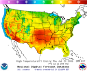
2006 North American heat wave
Beginning 15 July, a heat wave spread through United StatesUnited States
The United States of America is a federal constitutional republic comprising fifty states and a federal district...
and Canada
Canada
Canada is a North American country consisting of ten provinces and three territories. Located in the northern part of the continent, it extends from the Atlantic Ocean in the east to the Pacific Ocean in the west, and northward into the Arctic Ocean...
. It lasted until 27 August in different parts of the countries. In California
California
California is a state located on the West Coast of the United States. It is by far the most populous U.S. state, and the third-largest by land area...
, in particular, many records were broken, the state experiencing higher temperatures for longer periods of time than ever before. On July 22, a temperature of 119 °F / 49 °C was recorded in Woodland Hills
Woodland Hills, Los Angeles, California
Woodland Hills is a district in the city of Los Angeles, California.Woodland Hills is located in the southwestern area of the San Fernando Valley, east of Calabasas and west of Tarzana, with Warner Center in its northern section...
in Los Angeles County
Los Angeles County, California
Los Angeles County is a county in the U.S. state of California. As of 2010 U.S. Census, the county had a population of 9,818,605, making it the most populous county in the United States. Los Angeles County alone is more populous than 42 individual U.S. states...
. At least 225 deaths have been attributed to the heat wave. Also, it is considered to have played a part in many incidents that increased in frequency or severity during the heat wave, such as forest fires, ruptured water lines, buckled roads, thunderstorm
Thunderstorm
A thunderstorm, also known as an electrical storm, a lightning storm, thundershower or simply a storm is a form of weather characterized by the presence of lightning and its acoustic effect on the Earth's atmosphere known as thunder. The meteorologically assigned cloud type associated with the...
s and blackout
Power outage
A power outage is a short- or long-term loss of the electric power to an area.There are many causes of power failures in an electricity network...
s in the power grid.
Tropical cyclone seasons in 2006
Following the record-breaking 2005 Atlantic hurricane season2005 Atlantic hurricane season
The 2005 Atlantic hurricane season was the most active Atlantic hurricane season in recorded history, repeatedly shattering numerous records. The impact of the season was widespread and ruinous with an estimated 3,913 deaths and record damage of about $159.2 billion...
, the 2006 season was relatively quiet in the Northern Atlantic Ocean
Atlantic Ocean
The Atlantic Ocean is the second-largest of the world's oceanic divisions. With a total area of about , it covers approximately 20% of the Earth's surface and about 26% of its water surface area...
. There were 10 storms, of which two major ones (category 3 or more on the Saffir-Simpson Hurricane Scale
Saffir-Simpson Hurricane Scale
The Saffir–Simpson Hurricane Scale , or the Saffir–Simpson Hurricane Wind Scale , classifies hurricanes — Western Hemisphere tropical cyclones that exceed the intensities of tropical depressions and tropical storms — into five categories distinguished by the intensities of their sustained winds...
), compared to 28 storms with 7 major ones in 2005. No hurricanes made landfall in the United States
United States
The United States of America is a federal constitutional republic comprising fifty states and a federal district...
.
In the Northwestern Pacific Ocean
Pacific Ocean
The Pacific Ocean is the largest of the Earth's oceanic divisions. It extends from the Arctic in the north to the Southern Ocean in the south, bounded by Asia and Australia in the west, and the Americas in the east.At 165.2 million square kilometres in area, this largest division of the World...
, however, the season was busy. 23 tropical storms formed officially, of which 15 attained the status of a typhoon. 7 of them, moreover, reached an intensity that allowed them to be called super typhoons (intensity equal to or higher than 4 on the Saffir-Simpson Hurricane Scale). The high-speed winds, torrential rains and resulting floods caused thousands of fatalities and damage to infrastructure and economy.
See also
- 2006 Atlantic hurricane season2006 Atlantic hurricane seasonThe 2006 Atlantic hurricane season was significantly less active than the record previous season. It marked the first since 2001 in which no hurricanes made landfall in the United States, and was the first since 1994 that no tropical cyclones formed during October. Following the intense activity of...
- 2006 North Indian Ocean cyclone season
- 2006 Pacific hurricane season2006 Pacific hurricane seasonThe 2006 Pacific hurricane season was the most active Pacific hurricane season since 2000 producing 19 tropical storms or hurricanes. Eighteen developed within the National Hurricane Center area of warning responsibility, which is east of 140ºW, and one storm formed between 140ºW and the...
- 2006 Pacific typhoon season2006 Pacific typhoon seasonThe 2006 Pacific typhoon season had no official bounds; it ran year-round in 2006, but most tropical cyclones tend to form in the northwestern Pacific Ocean between May and November...
- 2005-06 Southern Hemisphere tropical cyclone season2005-06 Southern Hemisphere tropical cyclone seasonThe 2005–06 Southern Hemisphere tropical cyclone season comprises three different basins. Their respective seasons are:*2005-06 South-West Indian Ocean cyclone season west of 90°E,*2005-06 Australian region cyclone season between 90°E and 160°E, and...
- 2006-07 Southern Hemisphere tropical cyclone season2006-07 Southern Hemisphere tropical cyclone seasonThe 2006–07 Southern Hemisphere tropical cyclone season comprises three different basins. Their respective seasons are:*2006-07 South-West Indian Ocean cyclone season west of 90°E,*2006-07 Australian region cyclone season between 90°E and 160°E, and...
- Tornadoes of 2006Tornadoes of 2006This page documents the tornadoes and tornado outbreaks of 2006. Since the greatest coverage is in the United States, most of these events listed were primarily in the US...
- Global warmingGlobal warmingGlobal warming refers to the rising average temperature of Earth's atmosphere and oceans and its projected continuation. In the last 100 years, Earth's average surface temperature increased by about with about two thirds of the increase occurring over just the last three decades...