

Timeline of the 2008 Atlantic hurricane season
Encyclopedia
2008 Atlantic hurricane season
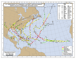
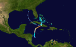
The 2008 Atlantic hurricane season was a very active hurricane season with sixteen named storms formed, including eight that became hurricanes and five that became major hurricanes. The season officially started on June 1 and ended on November 30. These dates conventionally delimit the period of...
was a well above-average year in which sixteen named storm
Tropical cyclone naming
Tropical cyclones have officially been named since 1945 and are named for a variety of reasons, which include to facilitate communications between forecasters and the public when forecasts, watches, and warnings are issued. Names also reduce confusion about what storm is being described, as more...
s formed, making it the fourth most active season ever recorded. An average season has eleven tropical storms, six hurricanes and two major hurricanes. Although Tropical Storm Arthur
Tropical Storm Arthur (2008)
Tropical Storm Arthur was the first Atlantic tropical storm that formed during the month of May since 1981. The first tropical cyclone of the 2008 Atlantic hurricane season, the storm formed on May 30 from the interaction of two tropical waves and the remnants of the eastern Pacific Tropical...
formed on May 30, 2008, the season officially began on June 1 and ended on November 30, dates that conventionally delimit the period of each year when most tropical cyclones develop in the Atlantic basin. The season's last storm, Hurricane Paloma, dissipated on November 10.
The season had seven tropical depression
Tropical cyclone
A tropical cyclone is a storm system characterized by a large low-pressure center and numerous thunderstorms that produce strong winds and heavy rain. Tropical cyclones strengthen when water evaporated from the ocean is released as the saturated air rises, resulting in condensation of water vapor...
s, of which sixteen intensified into tropical storms, eight became hurricanes, and five became major hurricanes. The high amount of activity throughout the basin was linked to the formation of a Neutral El Niño-Southern Oscillation (ENSO)
El Niño-Southern Oscillation
El Niño/La Niña-Southern Oscillation, or ENSO, is a quasiperiodic climate pattern that occurs across the tropical Pacific Ocean roughly every five years...
by the start of the season, which typically causes low wind shear
Wind shear
Wind shear, sometimes referred to as windshear or wind gradient, is a difference in wind speed and direction over a relatively short distance in the atmosphere...
across the Atlantic basin. The two most significant storms of the season, in terms of loss of life, were Hurricanes Gustav
Hurricane Gustav
The name Gustav has been used for five tropical cyclones in the Atlantic Ocean:* 1984's Tropical Storm Gustav - Spent most of its existence as a tropical depression hovering over Bermuda, no major damage was reported....
and Hanna
Hurricane Hanna (2008)
Hurricane Hanna was the deadliest storm of the 2008 Atlantic hurricane season. The storm was the eighth tropical cyclone and fourth hurricane of the 2008 Atlantic hurricane season. It formed east-northeast of the northern Leeward Islands on August 28...
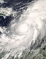
, which caused 153 deaths and 537 deaths, respectively. However, in terms of damage, Hurricane Ike
Hurricane Ike
Hurricane Ike was the second-costliest hurricane ever to make landfall in the United States, the costliest hurricane ever to impact Cuba and the second most active hurricane to reach the Canadian mainland in the Great Lakes Region after Hurricane Hazel in 1954...
was the most destructive, with total damage estimates equal to or greater than $37,600 (2008 USD). Every tropical cyclone, with the exception of Tropical Storm Nana, affected land in some way during the season.
This timeline includes information that was not operationally released, meaning that information from post-storm reviews by the National Hurricane Center
National Hurricane Center
The National Hurricane Center , located at Florida International University in Miami, Florida, is the division of the National Weather Service responsible for tracking and predicting weather systems within the tropics between the Prime Meridian and the 140th meridian west poleward to the 30th...
, such as a storm that was not operationally warned upon, has been included. This timeline documents tropical cyclone formations, strengthening, weakening, landfall
Landfall (meteorology)
Landfall is the event of a tropical cyclone or a waterspout coming onto land after being over water. When a waterspout makes landfall it is reclassified as a tornado, which can then cause damage inland...
s, extratropical transitions, and dissipations during the season.
May
May 30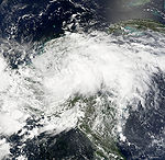
- 7 p.m. CDT (0000 UTCCoordinated Universal TimeCoordinated Universal Time is the primary time standard by which the world regulates clocks and time. It is one of several closely related successors to Greenwich Mean Time. Computer servers, online services and other entities that rely on having a universally accepted time use UTC for that purpose...
May 31) – Tropical Storm ArthurTropical Storm Arthur (2008)Tropical Storm Arthur was the first Atlantic tropical storm that formed during the month of May since 1981. The first tropical cyclone of the 2008 Atlantic hurricane season, the storm formed on May 30 from the interaction of two tropical waves and the remnants of the eastern Pacific Tropical...
forms 50 mileMileA mile is a unit of length, most commonly 5,280 feet . The mile of 5,280 feet is sometimes called the statute mile or land mile to distinguish it from the nautical mile...
s (80 km) east of Belize CityBelize CityBelize City is the largest city in the Central American nation of Belize. Unofficial estimates place the population of Belize City at 70,000 or more. It is located at the mouth of the Belize River on the coast of the Caribbean. The city is the country's principal port and its financial and...
, BelizeBelizeBelize is a constitutional monarchy and the northernmost country in Central America. Belize has a diverse society, comprising many cultures and languages. Even though Kriol and Spanish are spoken among the population, Belize is the only country in Central America where English is the official...
.
May 31
- 4 a.m. CDT (0900 UTC) – Tropical Storm Arthur makes landfall in northeastern Belize with winds of 45 mph (75 km/h).
June
June 1- 12 a.m. EDT (0400 UTC) – The 2008 Atlantic hurricane season officially begins.
- 7 a.m. CDT (1200 UTC) – Tropical Storm Arthur weakens to a tropical depression.
- 7 p.m. CDT (0000 UTC June 2) – Tropical Depression Arthur degenerates into an area of low pressureLow pressure areaA low-pressure area, or "low", is a region where the atmospheric pressure at sea level is below that of surrounding locations. Low-pressure systems form under areas of wind divergence which occur in upper levels of the troposphere. The formation process of a low-pressure area is known as...
shortly before dissipating.
July
July 3- 2 a.m. ASTUTC-4UTC−04-00 is an identifier for a time offset from UTC of −04.This offset is used in the Atlantic Standard Time Zone in Canada and the North American Eastern Time Zone during daylight saving time , in the Caribbean region this is considered as the Eastern Caribbean timezone...
(0600 UTC) – Tropical Depression Two forms 255 miles (410 km) south-southeast of the Cape VerdeCape VerdeThe Republic of Cape Verde is an island country, spanning an archipelago of 10 islands located in the central Atlantic Ocean, 570 kilometres off the coast of Western Africa...
Islands. - 8 a.m. AST (1200 UTC) – Tropical Depression Two strengthens into Tropical Storm BerthaHurricane Bertha (2008)Hurricane Bertha was a rare early season Cape Verde-type hurricane. It is both the longest-lived July Atlantic tropical cyclone on record, and the easternmost forming July tropical storm on record. The second named storm of the 2008 Atlantic hurricane season, Bertha developed from a tropical wave...
.
July 7
- 2 a.m. AST (0600 UTC) – Tropical Storm Bertha strengthens into a hurricane.
- 2 p.m. AST (1800 UTC) – Hurricane Bertha strengthens into a major hurricane—a storm with winds of 111 mph (178 km/h) or higher.
July 8
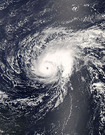
- 8 a.m. AST (1200 UTC) – Hurricane Bertha weakens to a Category 2 hurricane.
- 2 p.m. AST (1800 UTC) – Hurricane Bertha weakens to a Category 1 hurricane.
July 9
- 2 p.m. AST (1800 UTC) – Hurricane Bertha re-strengthens into a Category 2 hurricane.
July 10
- 8 a.m. AST (1200 UTC) – Hurricane Bertha weakens to a Category 1 hurricane again.
July 13
- 8 a.m. AST (1200 UTC) – Hurricane Bertha weakens to a tropical storm.
July 14
- 2 p.m. AST (1800 UTC) – Tropical Storm Bertha makes its closest approach to land, passing within 35 miles (55 km) west of BermudaBermudaBermuda is a British overseas territory in the North Atlantic Ocean. Located off the east coast of the United States, its nearest landmass is Cape Hatteras, North Carolina, about to the west-northwest. It is about south of Halifax, Nova Scotia, Canada, and northeast of Miami, Florida...
.
July 18
- 2 p.m. AST (1800 UTC) – Tropical Storm Bertha re-strengthens into a hurricane.
- 8 p.m. EDT (0000 UTC July 19) – Tropical Depression Three forms 70 miles (110 km) east of the GeorgiaGeorgia (U.S. state)Georgia is a state located in the southeastern United States. It was established in 1732, the last of the original Thirteen Colonies. The state is named after King George II of Great Britain. Georgia was the fourth state to ratify the United States Constitution, on January 2, 1788...
/South CarolinaSouth CarolinaSouth Carolina is a state in the Deep South of the United States that borders Georgia to the south, North Carolina to the north, and the Atlantic Ocean to the east. Originally part of the Province of Carolina, the Province of South Carolina was one of the 13 colonies that declared independence...
border.
July 19
- 8 a.m. EDT (1200 UTC) – Tropical Depression Three strengthens into Tropical Storm CristobalTropical Storm Cristobal (2008)Tropical Storm Cristobal was the third named storm of the 2008 Atlantic hurricane season. It formed on July 19 from a trough of low pressure off the Southeast U.S. Coast. In a marginally favorable environment, it attained minimal tropical storm status later that day. The storm remained offshore,...
. - 8 p.m. AST (0000 UTC July 20) – Hurricane Bertha weakens to a tropical storm again.
July 20
- 8 a.m. AST (1200 UTC) – Tropical Storm Bertha transitions into an extratropical cycloneExtratropical cycloneExtratropical cyclones, sometimes called mid-latitude cyclones or wave cyclones, are a group of cyclones defined as synoptic scale low pressure weather systems that occur in the middle latitudes of the Earth having neither tropical nor polar characteristics, and are connected with fronts and...
over the north-central AtlanticAtlantic OceanThe Atlantic Ocean is the second-largest of the world's oceanic divisions. With a total area of about , it covers approximately 20% of the Earth's surface and about 26% of its water surface area...
. - 8 a.m. EDT (1200 UTC) – Tropical Storm DollyHurricane Dolly (2008)Hurricane Dolly was a tropical cyclone that made landfall in extreme southern Texas in July 2008. Dolly was the fourth tropical cyclone and second hurricane to form during the 2008 Atlantic hurricane season. It was the first U.S. landfalling hurricane of the 2008 season. Dolly developed on July 20...
forms 310 mi (500 km) east of Chetumal, Mexico. - 2 p.m. EDT (1800 UTC) – Tropical Storm Cristobal makes its closest approach to land, passing within 25 miles (40 km) southeast of the Outer BanksOuter BanksThe Outer Banks is a 200-mile long string of narrow barrier islands off the coast of North Carolina, beginning in the southeastern corner of Virginia Beach on the east coast of the United States....
of North CarolinaNorth CarolinaNorth Carolina is a state located in the southeastern United States. The state borders South Carolina and Georgia to the south, Tennessee to the west and Virginia to the north. North Carolina contains 100 counties. Its capital is Raleigh, and its largest city is Charlotte...
with winds of 50 mph (80 km/h). - 1:30 a.m. CDT (0530 UTC July 21) – Tropical Storm Dolly makes landfall near CancunCancúnCancún is a city of international tourism development certified by the UNWTO . Located on the northeast coast of Quintana Roo in southern Mexico, more than 1,700 km from Mexico City, the Project began operations in 1974 as Integrally Planned Center, a pioneer of FONATUR Cancún is a city of...
, MexicoMexicoThe United Mexican States , commonly known as Mexico , is a federal constitutional republic in North America. It is bordered on the north by the United States; on the south and west by the Pacific Ocean; on the southeast by Guatemala, Belize, and the Caribbean Sea; and on the east by the Gulf of...
with winds of 50 mph (85 km/h).
July 22
- 7 p.m. CDT (0000 UTC July 23) – Tropical Storm Dolly strengthens into a hurricane.
July 23
- 8 a.m. EDT (1200 UTC) – Tropical Storm Cristobal dissipates as it is absorbed by a large extratropical cyclone.
- 9 a.m. CDT (1400 UTC) – Hurricane Dolly strengthens into a Category 2 hurricane and reaches its peak intensity with winds of 100 mph (160 km/h) and a minimum pressure of 963 mbar (hPa; 28.45 inHg).
- 1 p.m. CDT (1800 UTC) – Hurricane Dolly weakens to a Category 1 hurricane.
- 1:20 p.m. CDT (1820 UTC) – Hurricane Dolly makes landfall on South Padre IslandSouth Padre IslandSouth Padre Island is a barrier island in the U.S. state of Texas. It is located in Cameron County and is a popular vacation destination because the resort city South Padre Island is located on the island. The island itself is considered to have been settled by Padre Jose Nicolas Balli, who had a...
, TexasTexasTexas is the second largest U.S. state by both area and population, and the largest state by area in the contiguous United States.The name, based on the Caddo word "Tejas" meaning "friends" or "allies", was applied by the Spanish to the Caddo themselves and to the region of their settlement in...
with winds of 85 mph (150 km/h). - 3 p.m. CDT (2000 UTC) – Hurricane Dolly makes landfall about 12 mi (19 km) south of Port Mansfield, TexasPort Mansfield, TexasPort Mansfield is a census-designated place in Willacy County, Texas, United States. The population was 415 at the 2000 census.-Geography:Port Mansfield is located at ....
with winds of 80 mph (140 km/h).
July 24
- 1 a.m. CDT (0600 UTC) – Hurricane Dolly weakens to a tropical storm.
- 7 p.m. CDT (0000 UTC July 25) – Tropical Storm Dolly weakens to a tropical depression.
July 25
- 7 p.m. CDT (0000 UTC July 26) – Tropical Depression Dolly degenerates into an area of low pressure over northern Mexico.
August
August 3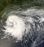
- 7 a.m. CDT (1200 UTC) – Tropical Depression Five forms 160 miles (260 km) south of Pensacola, FloridaPensacola, FloridaPensacola is the westernmost city in the Florida Panhandle and the county seat of Escambia County, Florida, United States of America. As of the 2000 census, the city had a total population of 56,255 and as of 2009, the estimated population was 53,752...
. - 7 p.m. CDT (0000 UTC August 4) – Tropical Depression Five strengthens into Tropical Storm EdouardTropical Storm Edouard (2008)Tropical Storm Edouard was a tropical storm that organized in the Gulf of Mexico. A shear line stalled in the northeastern Gulf of Mexico in early August as troughing aloft dug into the northeast Gulf of Mexico. This energy aloft help to organize a surface low along the shear line early on August...
.
August 5
- 7 a.m. CDT (1200 UTC) – Tropical Storm Edouard makes landfall near Gilchrist, TexasGilchrist, TexasGilchrist, Texas is an unincorporated residential community and beachfront resort along State Highway 87, located seventeen miles east of Bolivar Point in the Bolivar Peninsula census-designated place, in Galveston County, Texas, United States....
with winds of 65 mph (100 km/h). - 7 p.m. CDT (0000 UTC August 6) – Tropical Storm Edouard weakens to a tropical depression.
August 6
- 1 a.m. CDT (0600 UTC) – Tropical Depression Edouard degenerates into an area of low pressure.
August 15
- 8 a.m EDT (1200 UTC) – Tropical Depression Six forms just west of the northwestern tip of Puerto Rico.
- 10:30 a.m EDT (1430 UTC) – Tropical Depression Six makes its first landfall near El Cabo, Dominican Republic with winds of 40 mph (65 km/h).
- 2 p.m EDT (1800 UTC) – Tropical Depression Six is upgraded to Tropical Storm Fay.
August 16
- 7:45 a.m EDT (1145 UTC) – Tropical Storm Fay makes its second landfall along eastern Gonave Island, Haiti with winds of 45 mph (75 km/h).
August 17
- 5 a.m. EDT (0900 UTC) – Tropical Storm Fay makes its third landfall 20 miles east of Cabo Cruz, CubaCubaThe Republic of Cuba is an island nation in the Caribbean. The nation of Cuba consists of the main island of Cuba, the Isla de la Juventud, and several archipelagos. Havana is the largest city in Cuba and the country's capital. Santiago de Cuba is the second largest city...
with 50 mph (85 km/h) winds.
August 18
- 3 a.m. EDT (0700 UTC) – Tropical Storm Fay makes its fourth landfall 20 miles west of CienfuegosCienfuegosCienfuegos is a city on the southern coast of Cuba, capital of Cienfuegos Province. It is located about from Havana, and has a population of 150,000. The city is dubbed La Perla del Sur...
, CubaCubaThe Republic of Cuba is an island nation in the Caribbean. The nation of Cuba consists of the main island of Cuba, the Isla de la Juventud, and several archipelagos. Havana is the largest city in Cuba and the country's capital. Santiago de Cuba is the second largest city...
with 50 mph (85 km/h) winds. - 4:30 p.m. EDT (2030 UTC) – Tropical Storm Fay makes its fifth landfall in Key WestKey WestKey West is an island in the Straits of Florida on the North American continent at the southernmost tip of the Florida Keys. Key West is home to the southernmost point in the Continental United States; the island is about from Cuba....
, FloridaFloridaFlorida is a state in the southeastern United States, located on the nation's Atlantic and Gulf coasts. It is bordered to the west by the Gulf of Mexico, to the north by Alabama and Georgia and to the east by the Atlantic Ocean. With a population of 18,801,310 as measured by the 2010 census, it...
with 60 mph (90 km/h) winds.
August 19
- 4:45 a.m. EDT (0845 UTC) – Tropical Storm Fay makes its sixth landfall just east of Cape Romano, FloridaCape RomanoCape Romano is a cape at the southern end of Caxambas Island, just south of Marco Island and northwest of the Ten Thousand Islands in Collier County, Florida.Calusa Indians founded the settlement and called it Manataca...
with 65 mph (100 km/h) winds.
August 21
- 3 p.m. EDT (1900 UTC) – Tropical Storm Fay makes its seventh landfall near Flagler Beach, FloridaFlagler Beach, FloridaFlagler Beach is a city in Flagler and Volusia counties in the U.S. state of Florida. The population was 4,954 at the 2000 census, with an estimated population of 5,228 in 2004.Flagler Beach is part of the Palm Coast Metropolitan Statistical Area...
with 65 mph (100 km/h) winds.
August 23
- 2:15 a.m. EDT (0615 UTC) – Tropical Storm Fay makes its eighth landfall just southwest of Carrabelle, FloridaCarrabelle, FloridaCarrabelle is a city in Franklin County, Florida, United States. The population was 1,303 at the 2000 census. According to the U.S Census estimates of 2009, the city had a population of 1,231.-Location:...
with 50 mph (85 km/h) winds. - 7 p.m. CDT (0000 UTC August 24) – Tropical Storm Fay weakens to a tropical depression.
August 24
- 8 p.m. EDT (0000 UTC August 25) – Tropical Depression Seven forms 110 mi (175 km) northeast of Bonaire.
August 25
- 8 a.m. EDT (1200 UTC) – Tropical Depression Seven strengthens into Tropical Storm GustavHurricane GustavThe name Gustav has been used for five tropical cyclones in the Atlantic Ocean:* 1984's Tropical Storm Gustav - Spent most of its existence as a tropical depression hovering over Bermuda, no major damage was reported....
.
August 26
- 2 a.m. EDT (0600 UTC) – Tropical Storm Gustav strengthens into a hurricane.
- 2 p.m. EDT (1800 UTC) – Hurricane Gustav makes its first landfall on the southwestern peninsula of Haiti with winds of 80 mph (130 km/h).
- 8 p.m. EDT (0000 UTC August 27) – Hurricane Gustav weakens to a tropical storm.
August 27
- 2 a.m. EDT (0600 UTC) – Tropical Depression Fay becomes extratropical over eastern TennesseeTennesseeTennessee is a U.S. state located in the Southeastern United States. It has a population of 6,346,105, making it the nation's 17th-largest state by population, and covers , making it the 36th-largest by total land area...
. - 8 p.m. EDT (0000 UTC August 28) – Tropical Depression Eight forms 315 mi (510 km) east-northeast of the Lesser AntillesLesser AntillesThe Lesser Antilles are a long, partly volcanic island arc in the Western Hemisphere. Most of its islands form the eastern boundary of the Caribbean Sea with the Atlantic Ocean, with the remainder located in the southern Caribbean just north of South America...
.
August 28
- 8 a.m. EDT (1200 UTC) – Tropical Depression Eight strengthens into Tropical Storm HannaHurricane Hanna (2008)Hurricane Hanna was the deadliest storm of the 2008 Atlantic hurricane season. The storm was the eighth tropical cyclone and fourth hurricane of the 2008 Atlantic hurricane season. It formed east-northeast of the northern Leeward Islands on August 28...
. - 2 p.m. EDT (1800 UTC) – Tropical Storm Gustav makes its second landfall near Manchioneal, JamaicaManchioneal, JamaicaManchioneal is a settlement in Jamaica. It has a population of 2,292 as of 2009....
with winds of 70 mph (110 km/h). - 10 p.m. EDT (0000 UTC August 29) – Tropical Storm Gustav makes its third landfall near Lionel Town, JamaicaLionel Town, JamaicaLionel Town is a settlement in Jamaica. It has a population of 5,416 as of 2009. Lionel Town has a Community Hospital....
with winds of 70 mph (110 km/h).
August 29
- 2 p.m. EDT (1800 UTC) – Tropical Storm Gustav re-strengthens into a hurricane.
August 30
- 2 a.m. EDT (0600 UTC) – Hurricane Gustav strengthens into a Category 2 hurricane.
- 8 a.m. EDT (1200 UTC) – Hurricane Gustav strengthens into a major hurricane.
- 2 p.m. EDT (1800 UTC) – Hurricane Gustav strengthens into a Category 4 hurricane and makes landfall on the southeastern coast of the Isla de la Juventud, CubaCubaThe Republic of Cuba is an island nation in the Caribbean. The nation of Cuba consists of the main island of Cuba, the Isla de la Juventud, and several archipelagos. Havana is the largest city in Cuba and the country's capital. Santiago de Cuba is the second largest city...
- 6 p.m. EDT (2200 UTC) – Hurricane Gustav makes landfall near Los Palacios, CubaLos Palacios, CubaLos Palacios is a municipality and city in the Pinar del Río Province of Cuba.The municipality is divided into the barrios of Limones, Macurijes, Paso Real, Santa Mónica, Santo Domingo, Sierra and Urbano.It was founded in 1760.-Demographics:...
at peak intensity with winds of 150 mph (240 km/h) with a minimum pressure of 941 mbar (hPa; 27.79 inHg).
August 31
- 2 a.m. EDT (0600 UTC) – Hurricane Gustav weakens to a Category 3 hurricane.
- 2 p.m. EDT (1800 UTC) – Hurricane Gustav weakens to a Category 2 hurricane.
September
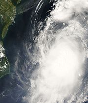
September 1- 2 a.m. AST (0600 UTC) – Tropical Depression Nine forms 775 mi (1,250 km) west of the Cape Verde Islands.
- 8 a.m. AST (1200 UTC) – Tropical Depression Nine strengthens into Tropical Storm IkeHurricane IkeHurricane Ike was the second-costliest hurricane ever to make landfall in the United States, the costliest hurricane ever to impact Cuba and the second most active hurricane to reach the Canadian mainland in the Great Lakes Region after Hurricane Hazel in 1954...
. - 10 a.m. CDT (1500 UTC) – Hurricane Gustav makes its final landfall near Cocodrie, LouisianaCocodrie, LouisianaCocodrie is an unincorporated fishing, shrimping and crabbing village in Terrebonne Parish, Louisiana, United States, ten miles south of Chauvin, due south of the larger town of Houma. It is part of the Houma–Bayou Cane–Thibodaux Metropolitan Statistical Area...
with winds of 105 mph (165 km/h). - 2 p.m. EDT (1800 UTC) – Tropical Storm Hanna strengthens into a hurricane.
- 7 p.m. CDT (0000 UTC) – Hurricane Gustav weakens to a tropical storm.
- 8 p.m. AST (0000 UTC September 2) – Tropical Depression Ten forms 315 mi (510 km) south-southeast of Sal, Cape VerdeSal, Cape VerdeSal is an island in Cape Verde. It belongs to the northern group of islands, called Barlavento. The island is composed by a single administrative division, the Sal municipality. The island is home to Amílcar Cabral International Airport, the main airport of Cape Verde.- Geography :The island is...
. - 8 p.m. EDT (0000 UTC September 2) – Hurricane Hanna passes over the Caicos Islands at peak intensity with winds of 85 mph (140 km/h).
September 2
- 2 a.m. AST (0600 UTC) – Tropical Depression Ten strengthens into Tropical Storm JosephineTropical Storm Josephine (2008)Tropical Storm Josephine was the tenth tropical storm of the 2008 Atlantic hurricane season. Josephine developed out of a strong tropical wave which moved off the African coast on August 31. The wave quickly became organized and was declared Tropical Depression Ten while located 170 mi ...
. - 7 a.m. CDT (1200 UTC) – Tropical Storm Gustav weakens to a tropical depression.
- 8 a.m. EDT (1200 UTC) – Hurricane Hanna weakens to a tropical storm.
September 3
- 2 p.m. AST (1800 UTC) – Tropical Storm Ike strengthens into a hurricane.
- 3 p.m. EDT (1900 UTC) – Tropical Storm Hanna passes over the Caicos Islands again with winds of 60 mph (95 km/h).
- 8 p.m. AST (0000 UTC September 4) – Hurricane Ike rapidly strengthensRapid deepeningRapid deepening, also known as rapid intensification, is a meteorological condition that occurs when the minimum sea-level atmospheric pressure of a tropical cyclone decreases drastically in a short period of time. The National Weather Service describes rapid deepening as a decrease of...
into a major hurricane.
September 4
- 2 a.m. AST (0600 UTC) – Hurricane Ike strengthens into a Category 4 hurricane and reaches its peak intensity with winds of 145 mph (230 km/h) with a minimum pressure of 935 mbar (hPa; 27.61 inHg) while located about 545 mi (880 km) northwest of BarbudaBarbudaBarbuda is an island in the Eastern Caribbean, and forms part of the state of Antigua and Barbuda. It has a population of about 1,500, most of whom live in the town of Codrington.-Location:...
, becoming the strongest storm of the season. - 7 a.m. CDT (1200 UTC) – Tropical Depression Gustav transitions into an extratropical cyclone over extreme north-central ArkansasArkansasArkansas is a state located in the southern region of the United States. Its name is an Algonquian name of the Quapaw Indians. Arkansas shares borders with six states , and its eastern border is largely defined by the Mississippi River...
.
September 5
- 8 a.m. AST (1200 UTC) – Hurricane Ike weakens to a Category 3 hurricane.
- 8 p.m. AST (0000 UTC September 6) – Tropical Storm Josephine weakens to a tropical depression.
September 6
- 2 a.m. AST (0600 UTC) – Tropical Depression Josephine degenerates into a remnant low pressure area.
- 3:20 a.m. EDT (0720 UTC) – Tropical Storm Hanna makes landfall near the North CarolinaNorth CarolinaNorth Carolina is a state located in the southeastern United States. The state borders South Carolina and Georgia to the south, Tennessee to the west and Virginia to the north. North Carolina contains 100 counties. Its capital is Raleigh, and its largest city is Charlotte...
--South CarolinaSouth CarolinaSouth Carolina is a state in the Deep South of the United States that borders Georgia to the south, North Carolina to the north, and the Atlantic Ocean to the east. Originally part of the Province of Carolina, the Province of South Carolina was one of the 13 colonies that declared independence...
border with winds of 70 mph (110 km/h). - 8 a.m. AST (1200 UTC) – Hurricane Ike weakens to a Category 2 hurricane.
- 2 p.m. AST (1800 UTC) – Hurricane Ike quickly re-strengthens into a Category 4 hurricane.
September 7
- 2 a.m. EDT (0600 UTC) – Tropical Storm Hanna transitions into an extratropical cyclone over New EnglandNew EnglandNew England is a region in the northeastern corner of the United States consisting of the six states of Maine, New Hampshire, Vermont, Massachusetts, Rhode Island, and Connecticut...
. - 2 a.m. AST (0600 UTC) – Hurricane Ike passes just south of the Turks and Caicos Islands with winds of 135 mph (215 km/h).
- 9 a.m. EDT (1300 UTC) – Hurricane Ike weakens to a Category 3 hurricane and passes over Great Inagua Island with winds of 125 mph (205 km/h).
- 8 p.m. EDT (0000 UTC September 8) – Hurricane Ike re-strengthens into a Category 4 hurricane.
- 10 p.m. EDT (0200 UTC September 8) – Hurricane Ike makes landfall near Cabo Lucrecia, Cuba with winds of 135 mph (215 km/h).
September 8
- 2 a.m. EDT (0600 UTC) – Hurricane Ike weakens to a Category 3 hurricane.
- 8 a.m. EDT (1200 UTC) – Hurricane Ike weakens to a Category 2 hurricane.
- 11 a.m. EDT (1500 UTC) – Hurricane Ike enters the Caribbean SeaCaribbean SeaThe Caribbean Sea is a sea of the Atlantic Ocean located in the tropics of the Western hemisphere. It is bounded by Mexico and Central America to the west and southwest, to the north by the Greater Antilles, and to the east by the Lesser Antilles....
and weakens to a Category 1 hurricane.
September 9
- 10 a.m. EDT (1400 UTC) – Hurricane Ike makes landfall near Punta La Capitana, Cuba with winds of 80 mph (130 km/h).
September 10
- 2 p.m. EDT (1800 UTC) – Hurricane Ike re-strengthens into a Category 2 hurricane.
September 13
- 2 a.m. CDT (0700 UTC) – Hurricane Ike makes its final landfall near Galveston, TexasGalveston, TexasGalveston is a coastal city located on Galveston Island in the U.S. state of Texas. , the city had a total population of 47,743 within an area of...
with winds of 110 mph (175 km/h). - 1 p.m. CDT (1800 UTC) – Hurricane Ike weakens to a tropical storm.
September 14
- 7 a.m. CDT (1200 UTC) – Tropical Storm Ike transitions into an extratropical cyclone over eastern MissouriMissouriMissouri is a US state located in the Midwestern United States, bordered by Iowa, Illinois, Kentucky, Tennessee, Arkansas, Oklahoma, Kansas and Nebraska. With a 2010 population of 5,988,927, Missouri is the 18th most populous state in the nation and the fifth most populous in the Midwest. It...
.
September 24
- 8 p.m. AST (0000 UTC September 25) – Tropical Depression Eleven (not operationally classified as such) forms 115 mi (185 km) north of the Dominican RepublicDominican RepublicThe Dominican Republic is a nation on the island of La Hispaniola, part of the Greater Antilles archipelago in the Caribbean region. The western third of the island is occupied by the nation of Haiti, making Hispaniola one of two Caribbean islands that are shared by two countries...
.
September 25
- 2 a.m. AST (0600 UTC) – Tropical Depression Eleven strengthens into Tropical Storm KyleHurricane Kyle (2008)Hurricane Kyle was the eleventh tropical storm and sixth hurricane of the 2008 Atlantic hurricane season. It formed from a strong tropical disturbance that tracked across the northeastern Caribbean Sea in the third week of September...
.
September 27
- 8 a.m. AST (1200 UTC) – Tropical Storm Kyle strengthens into a hurricane.
September 28
- 8 p.m. AST (0000 UTC September 29) – Hurricane Kyle makes landfall near Yarmouth, Nova ScotiaYarmouth, Nova ScotiaYarmouth is a town and fishing port located on the Gulf of Maine in rural southwestern Nova Scotia, Canada. It is the shire town of Yarmouth County. The town is located in the heart of the world's largest lobster fishing grounds and has Canada's highest lobster catch.- History :The townsite may...
with winds of 75 mph (120 km/h).
September 29'
- 2 a.m. AST (0600 UTC) – Hurricane Kyle transitions into an extratropical cyclone over Nova ScotiaNova ScotiaNova Scotia is one of Canada's three Maritime provinces and is the most populous province in Atlantic Canada. The name of the province is Latin for "New Scotland," but "Nova Scotia" is the recognized, English-language name of the province. The provincial capital is Halifax. Nova Scotia is the...
. - 2 a.m. EDT (0600 UTC) – Subtropical Storm Laura forms in the Atlantic OceanAtlantic OceanThe Atlantic Ocean is the second-largest of the world's oceanic divisions. With a total area of about , it covers approximately 20% of the Earth's surface and about 26% of its water surface area...
.
September 30
- 8 a.m. EDT (1200 UTC) – Subtropical Storm Laura is reclassified as Tropical Storm Laura.
October
October 1- 8 a.m. AST (1200 UTC) – Tropical Storm Laura degenerates into a remnant low in the north-central Atlantic.
October 5
- 7 p.m. CDT (0000 UTC October 6) – Tropical Depression Thirteen forms while located over Laguna de TérminosLaguna de TérminosLaguna de Términos is made up of a series of rich, sediment-laden lagoons and tidal estuaries connected by two channels to the Bay of Campeche in the southern part of Gulf of Mexico, in Carmen Municipality in the southwestern part of the Mexican state of Campeche. Its shores are swampy and support...
, MexicoMexicoThe United Mexican States , commonly known as Mexico , is a federal constitutional republic in North America. It is bordered on the north by the United States; on the south and west by the Pacific Ocean; on the southeast by Guatemala, Belize, and the Caribbean Sea; and on the east by the Gulf of...
.
October 6
- 7 a.m. CDT (1200 UTC) – Tropical Depression Thirteen strengthens into Tropical Storm MarcoTropical Storm Marco (2008)Tropical Storm Marco was the smallest known tropical cyclone on record. The thirteenth named storm of the 2008 Atlantic hurricane season, Marco developed out of a broad area of low pressure over the northwestern Caribbean during late September 2008. Influenced by a tropical wave on October 4,...
.
October 7
- 7 a.m. CDT (1200 UTC) – Tropical Storm Marco makes landfall near Misantla, Mexico with winds of 65 mph (100 km/h).
- 1 p.m. CDT (1800 UTC) – Tropical Storm Marco weakens to a tropical depression.
- 7 p.m. CDT (0000 UTC October 8) – Tropical Depression Marco dissipates over Mexico.
October 12
- 2 a.m. AST (0600 UTC) – Tropical Depression Fourteen (not operationally classified as such) forms 795 mi (1,280 km) west of the Cape Verde Islands.
- 8 a.m. AST (1200 UTC) – Tropical Depression Fourteen strengthens into Tropical Storm Nana.
October 13
- 8 a.m. AST (1200 UTC) – Tropical Storm Nana weakens to a tropical depression.
- 2 a.m. EDT (0600 UTC) – Tropical Depression Fifteen forms in the Caribbean Sea.
- 8 p.m. EDT (0000 UTC October 14) – Tropical Depression Fifteen strengthens into Tropical Storm OmarHurricane Omar (2008)Hurricane Omar was a strong hurricane that took an unusual southwest to northeast track through the eastern Caribbean Sea during October, 2008. Forming out of a tropical disturbance on October 13, Omar initially moved slowly in the eastern Caribbean Sea. By October 15, Omar began to...
.
October 14
- 8 a.m. AST (1200 UTC) – Tropical Depression Nana degenerates into a remnant low-pressure area over open waters.
- 8 a.m. EDT (1200 UTC) – Tropical Depression SixteenTropical Depression Sixteen (2008)Tropical Depression Sixteen was the only tropical cyclone not to intensify into a tropical storm during the 2008 Atlantic hurricane season. The sixteenth tropical cyclone of the season, Tropical Depression Sixteen developed partially from a tropical wave in the western Caribbean Sea on October 14...
forms 50 miles (80 km) northeast of the HondurasHondurasHonduras is a republic in Central America. It was previously known as Spanish Honduras to differentiate it from British Honduras, which became the modern-day state of Belize...
/NicaraguaNicaraguaNicaragua is the largest country in the Central American American isthmus, bordered by Honduras to the north and Costa Rica to the south. The country is situated between 11 and 14 degrees north of the Equator in the Northern Hemisphere, which places it entirely within the tropics. The Pacific Ocean...
border. - 8 p.m. EDT (0000 UTC October 15) – Tropical Storm Omar strengthens into Hurricane Omar.
October 15
- 8:30 a.m. EDT (1230 UTC) – Tropical Depression Sixteen makes landfall near Punta Patuca, Honduras with winds of 30 mph (45 km/h).
- 8 p.m. EDT (0000 UTC October 16) – Hurricane Omar reaches Category 2 intensity.
- 8 p.m. EDT (0000 UTC October 16) – Tropical Depression Sixteen degenerates into an area of low pressure shortly before dissipating over the mountains of Honduras.
October 16
- 2 a.m. EDT (0600 UTC) – Hurricane Omar reaches Category 4 intensity.
- 2 a.m. EDT (1800 UTC) – Hurricane Omar weakens to Category 1 intensity.
October 18
- 8 p.m. EDT (0000 UTC October 18) – Hurricane Omar weakens to a tropical storm.
- 8 a.m. AST (1200 UTC) – Tropical Storm Omar degenerates into a remnant low.
November
November 5- 4 p.m. EST (2100 UTC) – Tropical Depression Seventeen forms southeast of the NicaraguaNicaraguaNicaragua is the largest country in the Central American American isthmus, bordered by Honduras to the north and Costa Rica to the south. The country is situated between 11 and 14 degrees north of the Equator in the Northern Hemisphere, which places it entirely within the tropics. The Pacific Ocean...
/HondurasHondurasHonduras is a republic in Central America. It was previously known as Spanish Honduras to differentiate it from British Honduras, which became the modern-day state of Belize...
border.
- 1 a.m. EST (0600 UTC) – Tropical Depression Seventeen strengthens into Tropical Storm Paloma.
- 7 p.m. EST (0000 UTC November 7) – Tropical Storm Paloma strengthens into Hurricane Paloma.
November 7
- 7 p.m. EST (0000 UTC November 8) – Hurricane Paloma reaches Category 3 intensity.
November 8
- 7 a.m. EST (1200 UTC) – Hurricane Paloma reaches Category 4 intensity.
- 7 p.m. EST (0000 UTC November 9) – Hurricane Paloma weakens to Category 2 intensity.
- 8 p.m. EST (0100 UTC November 9) – Hurricane Paloma makes landfall near Santa Cruz del SurSanta Cruz del SurSanta Cruz del Sur is a town and municipality in Cuba. It is located in Camagüey Province south of the provincial capital of Camagüey. It lies on the Caribbean coast....
, CubaCubaThe Republic of Cuba is an island nation in the Caribbean. The nation of Cuba consists of the main island of Cuba, the Isla de la Juventud, and several archipelagos. Havana is the largest city in Cuba and the country's capital. Santiago de Cuba is the second largest city...
with 100 mph (160 km/h) winds.
November 9
- 1 a.m. EST (0600 UTC) – Hurricane Paloma weakens to a tropical storm.
- 1 p.m. EST (1800 UTC) – Tropical Storm Paloma weakens to a tropical depression.
- 7 p.m. EST (0000 UTC November 10) – Tropical Depression Paloma degenerates to a remnant low over Cuba.
November 30
- 12 p.m. EST (0500 UTC) – The 2008 Atlantic hurricane season officially ends.
See also
- 2008 Atlantic hurricane season2008 Atlantic hurricane seasonThe 2008 Atlantic hurricane season was a very active hurricane season with sixteen named storms formed, including eight that became hurricanes and five that became major hurricanes. The season officially started on June 1 and ended on November 30. These dates conventionally delimit the period of...
- List of Atlantic hurricane seasons
- Timeline of the 2008 Pacific hurricane seasonTimeline of the 2008 Pacific hurricane seasonBelow is the Timeline of the 2008 Pacific hurricane season, documenting all the storm formations, strengthening, weakening, landfalls, extratropical transitions, as well as dissipation. The 2008 Pacific hurricane season officially began on May 15, 2008, and will last until November 30. For...
- Timeline of the 2008 Pacific typhoon seasonTimeline of the 2008 Pacific typhoon seasonThis timeline documents all the storm formations, strengthening, weakening, landfalls, extratropical transitions, as well as dissipation during the 2008 Pacific typhoon season. The 2008 Pacific typhoon season officially started on January 1, 2008 and ended on January 1, 2009. The first tropical...
- Timeline of the 2008 North Indian Ocean cyclone seasonTimeline of the 2008 North Indian Ocean cyclone seasonThe 2008 North Indian Ocean cyclone season officially ran throughout the year during 2008, with the first depression forming on April 27. The timeline includes information that was not operationally released, meaning that information from post-storm reviews by the Joint Typhoon Warning Center , and...
- Timeline of the 2007-08 South-West Indian Ocean cyclone seasonTimeline of the 2007-08 South-West Indian Ocean cyclone seasonBelow is a timeline of the 2007-08 South-West Indian Ocean cyclone season, documenting all the storm formations, strengthening, weakening, landfalls, extratropical transitions, as well as dissipation....
- Timeline of the 2007-08 South Pacific cyclone season
- Timeline of the 2007-08 Australian region cyclone seasonTimeline of the 2007-08 Australian region cyclone seasonThe 2007–08 Australian region cyclone season was only the second season to have a tropical cyclone form in July. This timeline documents all the storm formations, strengthening, weakening, landfalls, extratropical transitions, as well as dissipation. The season officially began on 1 November 2007,...