
.gif)
Tropical Storm Josephine (2008)
Encyclopedia
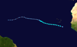
Tropical Storm Josephine was the tenth tropical storm
of the 2008 Atlantic hurricane season
. Josephine developed out of a strong tropical wave
which moved off the African coast on August 31. The wave quickly became organized and was declared Tropical Depression Ten while located 170 mi (270 km) to the south-southeast of the Cape Verde
Islands on September 2. The depression was quickly upgraded to Tropical Storm Josephine around noon the same day. Over the next several days, Josephine moved in a general west-northwest direction and reached its peak intensity early on September 3. Strong wind shear, some due to the outflow of Hurricane Ike
, and dry air caused the storm to weaken. On September 6, the combination of wind shear, dry air, and cooling waters caused Josephine to weaken into a tropical depression. Josephine deteriorated into a remnant low shortly after as convection
continued to dissipate around the storm. The low ultimately dissipated while located 520 mi (835 km) east of Guadeloupe
on September 10. However, the remnant moisture led to minor flooding on the island of St. Croix.
 Tropical Storm Josephine formed as a tropical wave
that emerged off the west coast of Africa near the end of August 2008. It tracked south of Cape Verde
and slowly developed, and on September 2 the disturbance became Tropical Depression Ten while located south-southeast of the Cape Verde islands. As the depression became more organized, an eye-like
feature developed in the upper levels of the system. The depression was upgraded to Tropical Storm Josephine six hours after forming. Josephine was located in an area which was supportive for rapid intensification
but was not forecast to intensify quickly.
Josephine continued to intensify throughout the afternoon as the storm became more symmetrical. However, due to the location of the storm, there was a lack of accurate wind speed readings, and the National Hurricane Center
was uncertain of its actual intensity. Despite the lack of wind shear
around the storm, the center became slightly exposed and ceased further intensification. The storm was also heading into an area where shear was forecasted to significantly increase due to an upper-level trough
diving southward. Despite convection
being partially removed from the center of Josephine, the storm intensified slightly in the early morning hours on September 3 as thunderstorm activity to the south of the center became more organized. The intensification was forecast to be short in duration as the trough to the north was deepening, causing the wind shear to the west to become stronger.
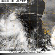 Josephine reached its peak intensity of 65 mph (100 km/h) around 8 a.m. (EDT
) as it continued to become more organized. However, there were indications that it had already begun to weaken. Outflow towards the north was becoming restricted and arc clouds began emanating from the storm, a sign that dry air was entering the system. During the afternoon hours, the structure of Josephine began to rapidly deteriorate as strong wind shear and dry air took their toll. By the late night, the center was almost completely exposed and only a band of convection persisted near the center.
Despite continuing effects from the strong wind shear, a large, deep burst of convection formed in the northern semicircle of Josephine. The center was found to have shifted towards the new convection leading to an increase in intensity. The forecast showed a slight decrease in wind shear as Josephine continued westward and no change in intensity over the 5-day forecast was predicted. However, the convection decreased once more and the low became completely exposed by the late morning hours and Josephine weakened again. By the afternoon, the center of Josephine was only a swirl of clouds, devoid of convection. During the overnight hours on September 4 into the morning of September 5, convection associated with Josephine began to redevelop somewhat, mostly to the north of the circulation, due to the strong southerly wind shear. By mid-morning, Josephine re-intensified slightly due to the redevelopment of some convection. However, the redevelopment was short lived and wind shear again took its toll on Josephine by late morning. The convection around the system became dislocated from the center and Josephine weakened slightly.
The weakening trend continued through the afternoon as the storm was being affected by strong southerly shear. Josephine became almost fully devoid of any convection by mid-afternoon and the storm weakened to 40 mph (65 km/h), barely holding on to tropical storm status. Josephine regained a small amount of convection in the late night hours, but not enough to still be classified a tropical storm. Due to the lack of convection, Josephine was downgraded to a Tropical Depression at 11p.m. (EDT) with winds of 35 mph (55 km/h). Since there was no convection around the system, it would have normally been classified a remnant low but, due to the possibility of the storm regenerating over the next several days, it was considered a tropical depression. The next morning, Josephine was downgraded to a remnant low as strong wind shear and dry air caused the demise of the storm. No redevelopment was expected with Josephine as it began to move over colder waters and remain under strong wind shear until it dissipated.
However, the remnant low associated with Josephine began to show signs of redevelopment during the afternoon on September 7. Convection around the system increased significantly and the low was no longer exposed. On September 8, wind shear took over the system again. Convection around the remnant low was torn away and the low was exposed once more. The National Hurricane Center did not state the chance of regeneration once the low became exposed. Finally, on September 9, wind shear and dry air led to the remnants of Josephine deteriorating into an open wave. However, on September 10, the remnants of Josephine redeveloped and global models picked up on the reformed system. Once more, the chance of regeneration was possible as the remnants of Josephine headed towards the Bahamas. However, on September 14, dry air and wind shear caused the remnants to dissipate entirely.
islands on September 2, outer rain bands produced minor rainfall, totaling around 0.55 inches (14 mm). There were no reports of damage or flooding from the rain and overall effects were minor.
Several days after the low dissipated, the remnant moisture from Josephine brought showers and thunderstorms to St. Croix where up to 1 in (25.4 mm) of rain fell. The heavy rains led to minor street flooding and some urban flooding. No known damage was caused by the flood.
Tropical cyclone
A tropical cyclone is a storm system characterized by a large low-pressure center and numerous thunderstorms that produce strong winds and heavy rain. Tropical cyclones strengthen when water evaporated from the ocean is released as the saturated air rises, resulting in condensation of water vapor...
of the 2008 Atlantic hurricane season
2008 Atlantic hurricane season
The 2008 Atlantic hurricane season was a very active hurricane season with sixteen named storms formed, including eight that became hurricanes and five that became major hurricanes. The season officially started on June 1 and ended on November 30. These dates conventionally delimit the period of...
. Josephine developed out of a strong tropical wave
Tropical wave
Tropical waves, easterly waves, or tropical easterly waves, also known as African easterly waves in the Atlantic region, are a type of atmospheric trough, an elongated area of relatively low air pressure, oriented north to south, which move from east to west across the tropics causing areas of...
which moved off the African coast on August 31. The wave quickly became organized and was declared Tropical Depression Ten while located 170 mi (270 km) to the south-southeast of the Cape Verde
Cape Verde
The Republic of Cape Verde is an island country, spanning an archipelago of 10 islands located in the central Atlantic Ocean, 570 kilometres off the coast of Western Africa...
Islands on September 2. The depression was quickly upgraded to Tropical Storm Josephine around noon the same day. Over the next several days, Josephine moved in a general west-northwest direction and reached its peak intensity early on September 3. Strong wind shear, some due to the outflow of Hurricane Ike
Hurricane Ike
Hurricane Ike was the second-costliest hurricane ever to make landfall in the United States, the costliest hurricane ever to impact Cuba and the second most active hurricane to reach the Canadian mainland in the Great Lakes Region after Hurricane Hazel in 1954...
, and dry air caused the storm to weaken. On September 6, the combination of wind shear, dry air, and cooling waters caused Josephine to weaken into a tropical depression. Josephine deteriorated into a remnant low shortly after as convection
Atmospheric convection
Atmospheric convection is the result of a parcel-environment instability, or temperature difference, layer in the atmosphere. Different lapse rates within dry and moist air lead to instability. Mixing of air during the day which expands the height of the planetary boundary layer leads to...
continued to dissipate around the storm. The low ultimately dissipated while located 520 mi (835 km) east of Guadeloupe
Guadeloupe
Guadeloupe is an archipelago located in the Leeward Islands, in the Lesser Antilles, with a land area of 1,628 square kilometres and a population of 400,000. It is the first overseas region of France, consisting of a single overseas department. As with the other overseas departments, Guadeloupe...
on September 10. However, the remnant moisture led to minor flooding on the island of St. Croix.
Meteorological history
Tropical wave
Tropical waves, easterly waves, or tropical easterly waves, also known as African easterly waves in the Atlantic region, are a type of atmospheric trough, an elongated area of relatively low air pressure, oriented north to south, which move from east to west across the tropics causing areas of...
that emerged off the west coast of Africa near the end of August 2008. It tracked south of Cape Verde
Cape Verde
The Republic of Cape Verde is an island country, spanning an archipelago of 10 islands located in the central Atlantic Ocean, 570 kilometres off the coast of Western Africa...
and slowly developed, and on September 2 the disturbance became Tropical Depression Ten while located south-southeast of the Cape Verde islands. As the depression became more organized, an eye-like
Eye (cyclone)
The eye is a region of mostly calm weather found at the center of strong tropical cyclones. The eye of a storm is a roughly circular area and typically 30–65 km in diameter. It is surrounded by the eyewall, a ring of towering thunderstorms where the second most severe weather of a cyclone...
feature developed in the upper levels of the system. The depression was upgraded to Tropical Storm Josephine six hours after forming. Josephine was located in an area which was supportive for rapid intensification
Rapid deepening
Rapid deepening, also known as rapid intensification, is a meteorological condition that occurs when the minimum sea-level atmospheric pressure of a tropical cyclone decreases drastically in a short period of time. The National Weather Service describes rapid deepening as a decrease of...
but was not forecast to intensify quickly.
Josephine continued to intensify throughout the afternoon as the storm became more symmetrical. However, due to the location of the storm, there was a lack of accurate wind speed readings, and the National Hurricane Center
National Hurricane Center
The National Hurricane Center , located at Florida International University in Miami, Florida, is the division of the National Weather Service responsible for tracking and predicting weather systems within the tropics between the Prime Meridian and the 140th meridian west poleward to the 30th...
was uncertain of its actual intensity. Despite the lack of wind shear
Wind shear
Wind shear, sometimes referred to as windshear or wind gradient, is a difference in wind speed and direction over a relatively short distance in the atmosphere...
around the storm, the center became slightly exposed and ceased further intensification. The storm was also heading into an area where shear was forecasted to significantly increase due to an upper-level trough
Trough (meteorology)
A trough is an elongated region of relatively low atmospheric pressure, often associated with fronts.Unlike fronts, there is not a universal symbol for a trough on a weather chart. The weather charts in some countries or regions mark troughs by a line. In the United States, a trough may be marked...
diving southward. Despite convection
Atmospheric convection
Atmospheric convection is the result of a parcel-environment instability, or temperature difference, layer in the atmosphere. Different lapse rates within dry and moist air lead to instability. Mixing of air during the day which expands the height of the planetary boundary layer leads to...
being partially removed from the center of Josephine, the storm intensified slightly in the early morning hours on September 3 as thunderstorm activity to the south of the center became more organized. The intensification was forecast to be short in duration as the trough to the north was deepening, causing the wind shear to the west to become stronger.
Eastern Standard Time
Eastern Standard Time may refer to:*North American Eastern Time Zone, UTC-5*Australian Eastern Standard Time, UTC+10*An album by Hip Hop group Kooley High...
) as it continued to become more organized. However, there were indications that it had already begun to weaken. Outflow towards the north was becoming restricted and arc clouds began emanating from the storm, a sign that dry air was entering the system. During the afternoon hours, the structure of Josephine began to rapidly deteriorate as strong wind shear and dry air took their toll. By the late night, the center was almost completely exposed and only a band of convection persisted near the center.
Despite continuing effects from the strong wind shear, a large, deep burst of convection formed in the northern semicircle of Josephine. The center was found to have shifted towards the new convection leading to an increase in intensity. The forecast showed a slight decrease in wind shear as Josephine continued westward and no change in intensity over the 5-day forecast was predicted. However, the convection decreased once more and the low became completely exposed by the late morning hours and Josephine weakened again. By the afternoon, the center of Josephine was only a swirl of clouds, devoid of convection. During the overnight hours on September 4 into the morning of September 5, convection associated with Josephine began to redevelop somewhat, mostly to the north of the circulation, due to the strong southerly wind shear. By mid-morning, Josephine re-intensified slightly due to the redevelopment of some convection. However, the redevelopment was short lived and wind shear again took its toll on Josephine by late morning. The convection around the system became dislocated from the center and Josephine weakened slightly.
The weakening trend continued through the afternoon as the storm was being affected by strong southerly shear. Josephine became almost fully devoid of any convection by mid-afternoon and the storm weakened to 40 mph (65 km/h), barely holding on to tropical storm status. Josephine regained a small amount of convection in the late night hours, but not enough to still be classified a tropical storm. Due to the lack of convection, Josephine was downgraded to a Tropical Depression at 11p.m. (EDT) with winds of 35 mph (55 km/h). Since there was no convection around the system, it would have normally been classified a remnant low but, due to the possibility of the storm regenerating over the next several days, it was considered a tropical depression. The next morning, Josephine was downgraded to a remnant low as strong wind shear and dry air caused the demise of the storm. No redevelopment was expected with Josephine as it began to move over colder waters and remain under strong wind shear until it dissipated.
However, the remnant low associated with Josephine began to show signs of redevelopment during the afternoon on September 7. Convection around the system increased significantly and the low was no longer exposed. On September 8, wind shear took over the system again. Convection around the remnant low was torn away and the low was exposed once more. The National Hurricane Center did not state the chance of regeneration once the low became exposed. Finally, on September 9, wind shear and dry air led to the remnants of Josephine deteriorating into an open wave. However, on September 10, the remnants of Josephine redeveloped and global models picked up on the reformed system. Once more, the chance of regeneration was possible as the remnants of Josephine headed towards the Bahamas. However, on September 14, dry air and wind shear caused the remnants to dissipate entirely.
Impact
As Josephine passed to the south of the Cape VerdeCape Verde
The Republic of Cape Verde is an island country, spanning an archipelago of 10 islands located in the central Atlantic Ocean, 570 kilometres off the coast of Western Africa...
islands on September 2, outer rain bands produced minor rainfall, totaling around 0.55 inches (14 mm). There were no reports of damage or flooding from the rain and overall effects were minor.
Several days after the low dissipated, the remnant moisture from Josephine brought showers and thunderstorms to St. Croix where up to 1 in (25.4 mm) of rain fell. The heavy rains led to minor street flooding and some urban flooding. No known damage was caused by the flood.
See also
- Other storms of the same name
- Timeline of the 2008 Atlantic hurricane seasonTimeline of the 2008 Atlantic hurricane seasonThe 2008 Atlantic hurricane season was a well above-average year in which sixteen named storms formed, making it the fourth most active season ever recorded. An average season has eleven tropical storms, six hurricanes and two major hurricanes...