
.gif)
Tropical Storm Cristobal (2008)
Encyclopedia
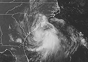
Tropical Storm Cristobal was the third named storm of the 2008 Atlantic hurricane season
. It formed on July 19 from a trough
of low pressure off the Southeast U.S. Coast. In a marginally favorable environment, it attained minimal tropical storm status later that day. The storm remained offshore, and peaked as a strong tropical storm on July 21 while it passed east of Cape Hatteras
. It accelerated northeast parallel to the East Coast and became extratropical on July 23 near Nova Scotia
. Because it was a weak storm and never made landfall, Cristobal's effects were mostly limited to moderate rainfall. The storm dropped 3.43 in (87 mm) of rain in Wilmington, North Carolina
, where minor flooding was reported. Additionally, the extratropical remnants contributed to rainfall on Nova Scotia which caused some street and basement flooding.
extended across northern Florida
, producing thunderstorms across the state. A weak low pressure area
developed on July 15 near Tallahassee
, which moved southeastward into the Gulf of Mexico
. Late on July 16 it crossed onshore near Tampa
, and development was not anticipated due to land interaction. Late on July 17, however, convection increased in association with the low, and the system quickly became better organized. Late on July 18, the National Hurricane Center
(NHC) remarked that a tropical depression was developing, with its convection becoming more concentrated around a circulation; at 11 p.m. EST on July 18 (0300 UTC
July 19), it was classified as Tropical Depression Three, about 65 miles (105 km) southeast of Charleston, South Carolina
.
 Located between a ridge
to its southeast and northwest, the depression moved slowly northeastward, and with a marginally favorable upper-level environment, it attained minimal tropical storm status during the early afternoon of July 19. Initially fairly disorganized with little deep convection, dry air in the mid- to-upper-levels of the atmosphere prevented immediate intensification. However, late on July 20 thunderstorm activity increased. Cristobal remained a fairly weak tropical storm as it tracked adjacent to the Carolina coast, and the storm never made landfall. It reached peak intensity as a strong tropical storm on July 21 while it passed east of Cape Hatteras
, and remained such over the warm Gulf Stream
waters as convection became strong over the southern portion of the circulation. Beginning to enter cooler waters, the cyclone accelerated east-northeastward on July 21 and July 22. On the afternoon of July 22, Cristobal began to weaken south of Nova Scotia
. In the evening hours, satellite imagery indicated that the mid-level center became separated from the low-level center. The storm's cloud pattern became disorganized, and by July 23 it had completed an extratropical
transition. The National Hurricane Center
issued its last advisory on the system at 5:00 am EDT (0900 UTC) on July 23.
forecasters advised against swimming due to high seas and potential rip currents. Environment Canada
issued rain warnings throughout portions of Nova Scotia
.
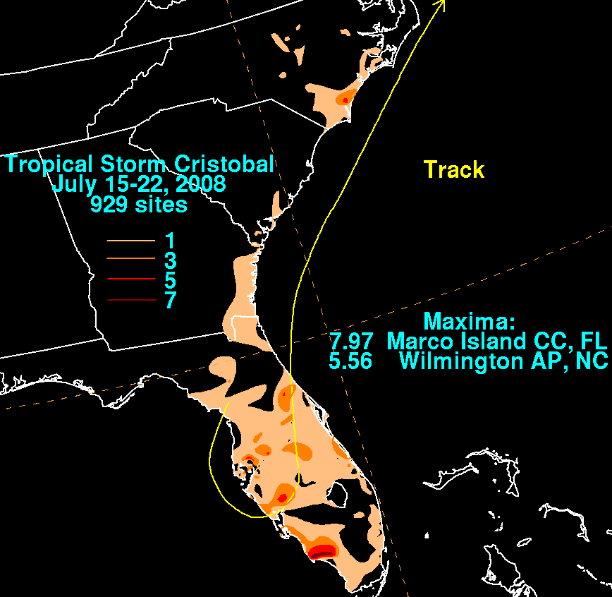 Prior to forming, the precursor low dropped light to moderate rainfall across the state of Florida
. In Lake Wales
, 6 inches (150 mm) of precipitation was reported, most of which fell within the period of two hours. The sudden, heavy rainfall clogged storm drains, causing some street flooding. Up to 40 cars were pulled from flooded streets, some being submerged with 2 ft (0.6 m) of water. Damages from the flooding was estimated at $10,000. In Georgia
, the storm produced 3.48 inches (88.4 mm) of rain, while in South Carolina
, 2.6 inches (66 mm) was recorded.
On July 20, Cristobal skirted eastern North Carolina, resulting in minimal damage. Along the coast, water levels rose 1 foot (0.3048 m) above normal; rough surf was also reported. Rainfall averaged 0.5 to 1.5 in (12.7 to 38.1 mm), though the NEXRAD
weather radar
estimates indicated that isolated amounts exceeded 4 inches (101.6 mm). The storm dropped 3.43 in (87.1 mm) in Wilmington, North Carolina
, where minor flooding occurred. Because the bulk of the storm remained over open waters, winds along the coast ran about 25 mph (40.2 km/h).
While the center of Cristobal was more than a day away from the Canadian Maritimes, moisture extended ahead of the cyclone and became enhanced by a stalled frontal system
. As a result, heavy rainfall fell along the Atlantic coast of Nova Scotia
. At Baccaro Point
, 224 mm (8.8 in) of rain was reported, while 145 mm (5.8 in) fell at Sambro
, near Halifax. The rain flooded basements and streets in the Cape Sable area. A sailor from Connecticut
was rescued 250 km (155.3 mi) to the southeast of Halifax when his ship capsized in stormy seas. The highest winds remained offshore, though a buoy recorded gusts to 58 miles per hour (93.3 km/h).
2008 Atlantic hurricane season
The 2008 Atlantic hurricane season was a very active hurricane season with sixteen named storms formed, including eight that became hurricanes and five that became major hurricanes. The season officially started on June 1 and ended on November 30. These dates conventionally delimit the period of...
. It formed on July 19 from a trough
Trough (meteorology)
A trough is an elongated region of relatively low atmospheric pressure, often associated with fronts.Unlike fronts, there is not a universal symbol for a trough on a weather chart. The weather charts in some countries or regions mark troughs by a line. In the United States, a trough may be marked...
of low pressure off the Southeast U.S. Coast. In a marginally favorable environment, it attained minimal tropical storm status later that day. The storm remained offshore, and peaked as a strong tropical storm on July 21 while it passed east of Cape Hatteras
Cape Hatteras
Cape Hatteras is a cape on the coast of North Carolina. It is the point that protrudes the farthest to the southeast along the northeast-to-southwest line of the Atlantic coast of North America...
. It accelerated northeast parallel to the East Coast and became extratropical on July 23 near Nova Scotia
Nova Scotia
Nova Scotia is one of Canada's three Maritime provinces and is the most populous province in Atlantic Canada. The name of the province is Latin for "New Scotland," but "Nova Scotia" is the recognized, English-language name of the province. The provincial capital is Halifax. Nova Scotia is the...
. Because it was a weak storm and never made landfall, Cristobal's effects were mostly limited to moderate rainfall. The storm dropped 3.43 in (87 mm) of rain in Wilmington, North Carolina
Wilmington, North Carolina
Wilmington is a port city in and is the county seat of New Hanover County, North Carolina, United States. The population is 106,476 according to the 2010 Census, making it the eighth most populous city in the state of North Carolina...
, where minor flooding was reported. Additionally, the extratropical remnants contributed to rainfall on Nova Scotia which caused some street and basement flooding.
Meteorological history
On July 14, 2008 a weakening surface troughTrough (meteorology)
A trough is an elongated region of relatively low atmospheric pressure, often associated with fronts.Unlike fronts, there is not a universal symbol for a trough on a weather chart. The weather charts in some countries or regions mark troughs by a line. In the United States, a trough may be marked...
extended across northern Florida
Florida
Florida is a state in the southeastern United States, located on the nation's Atlantic and Gulf coasts. It is bordered to the west by the Gulf of Mexico, to the north by Alabama and Georgia and to the east by the Atlantic Ocean. With a population of 18,801,310 as measured by the 2010 census, it...
, producing thunderstorms across the state. A weak low pressure area
Low pressure area
A low-pressure area, or "low", is a region where the atmospheric pressure at sea level is below that of surrounding locations. Low-pressure systems form under areas of wind divergence which occur in upper levels of the troposphere. The formation process of a low-pressure area is known as...
developed on July 15 near Tallahassee
Tallahassee, Florida
Tallahassee is the capital of the U.S. state of Florida. It is the county seat and only incorporated municipality in Leon County, and is the 128th largest city in the United States. Tallahassee became the capital of Florida, then the Florida Territory, in 1824. In 2010, the population recorded by...
, which moved southeastward into the Gulf of Mexico
Gulf of Mexico
The Gulf of Mexico is a partially landlocked ocean basin largely surrounded by the North American continent and the island of Cuba. It is bounded on the northeast, north and northwest by the Gulf Coast of the United States, on the southwest and south by Mexico, and on the southeast by Cuba. In...
. Late on July 16 it crossed onshore near Tampa
Tampa, Florida
Tampa is a city in the U.S. state of Florida. It serves as the county seat for Hillsborough County. Tampa is located on the west coast of Florida. The population of Tampa in 2010 was 335,709....
, and development was not anticipated due to land interaction. Late on July 17, however, convection increased in association with the low, and the system quickly became better organized. Late on July 18, the National Hurricane Center
National Hurricane Center
The National Hurricane Center , located at Florida International University in Miami, Florida, is the division of the National Weather Service responsible for tracking and predicting weather systems within the tropics between the Prime Meridian and the 140th meridian west poleward to the 30th...
(NHC) remarked that a tropical depression was developing, with its convection becoming more concentrated around a circulation; at 11 p.m. EST on July 18 (0300 UTC
Coordinated Universal Time
Coordinated Universal Time is the primary time standard by which the world regulates clocks and time. It is one of several closely related successors to Greenwich Mean Time. Computer servers, online services and other entities that rely on having a universally accepted time use UTC for that purpose...
July 19), it was classified as Tropical Depression Three, about 65 miles (105 km) southeast of Charleston, South Carolina
Charleston, South Carolina
Charleston is the second largest city in the U.S. state of South Carolina. It was made the county seat of Charleston County in 1901 when Charleston County was founded. The city's original name was Charles Towne in 1670, and it moved to its present location from a location on the west bank of the...
.
Ridge (meteorology)
A ridge is an elongated region of relatively high atmospheric pressure, the opposite of a trough....
to its southeast and northwest, the depression moved slowly northeastward, and with a marginally favorable upper-level environment, it attained minimal tropical storm status during the early afternoon of July 19. Initially fairly disorganized with little deep convection, dry air in the mid- to-upper-levels of the atmosphere prevented immediate intensification. However, late on July 20 thunderstorm activity increased. Cristobal remained a fairly weak tropical storm as it tracked adjacent to the Carolina coast, and the storm never made landfall. It reached peak intensity as a strong tropical storm on July 21 while it passed east of Cape Hatteras
Cape Hatteras
Cape Hatteras is a cape on the coast of North Carolina. It is the point that protrudes the farthest to the southeast along the northeast-to-southwest line of the Atlantic coast of North America...
, and remained such over the warm Gulf Stream
Gulf Stream
The Gulf Stream, together with its northern extension towards Europe, the North Atlantic Drift, is a powerful, warm, and swift Atlantic ocean current that originates at the tip of Florida, and follows the eastern coastlines of the United States and Newfoundland before crossing the Atlantic Ocean...
waters as convection became strong over the southern portion of the circulation. Beginning to enter cooler waters, the cyclone accelerated east-northeastward on July 21 and July 22. On the afternoon of July 22, Cristobal began to weaken south of Nova Scotia
Nova Scotia
Nova Scotia is one of Canada's three Maritime provinces and is the most populous province in Atlantic Canada. The name of the province is Latin for "New Scotland," but "Nova Scotia" is the recognized, English-language name of the province. The provincial capital is Halifax. Nova Scotia is the...
. In the evening hours, satellite imagery indicated that the mid-level center became separated from the low-level center. The storm's cloud pattern became disorganized, and by July 23 it had completed an extratropical
Extratropical cyclone
Extratropical cyclones, sometimes called mid-latitude cyclones or wave cyclones, are a group of cyclones defined as synoptic scale low pressure weather systems that occur in the middle latitudes of the Earth having neither tropical nor polar characteristics, and are connected with fronts and...
transition. The National Hurricane Center
National Hurricane Center
The National Hurricane Center , located at Florida International University in Miami, Florida, is the division of the National Weather Service responsible for tracking and predicting weather systems within the tropics between the Prime Meridian and the 140th meridian west poleward to the 30th...
issued its last advisory on the system at 5:00 am EDT (0900 UTC) on July 23.
Preparations
In anticipation of Tropical Storm Cristobal, a tropical storm warning was issued for coastal areas from the South Santee River in South Carolina to the North Carolina–Virginia Border. The advisory was discontinued on July 20 as Cristobal pulled away from land. Flood advisories were declared for parts of North Carolina. National Weather ServiceNational Weather Service
The National Weather Service , once known as the Weather Bureau, is one of the six scientific agencies that make up the National Oceanic and Atmospheric Administration of the United States government...
forecasters advised against swimming due to high seas and potential rip currents. Environment Canada
Environment Canada
Environment Canada , legally incorporated as the Department of the Environment under the Department of the Environment Act Environment Canada (EC) (French: Environnement Canada), legally incorporated as the Department of the Environment under the Department of the Environment Act Environment...
issued rain warnings throughout portions of Nova Scotia
Nova Scotia
Nova Scotia is one of Canada's three Maritime provinces and is the most populous province in Atlantic Canada. The name of the province is Latin for "New Scotland," but "Nova Scotia" is the recognized, English-language name of the province. The provincial capital is Halifax. Nova Scotia is the...
.
Impact
Florida
Florida is a state in the southeastern United States, located on the nation's Atlantic and Gulf coasts. It is bordered to the west by the Gulf of Mexico, to the north by Alabama and Georgia and to the east by the Atlantic Ocean. With a population of 18,801,310 as measured by the 2010 census, it...
. In Lake Wales
Lake Wales, Florida
Lake Wales is a city in Polk County, Florida, United States. The population was 10,194 at the 2000 census. As of 2004, the population recorded by the U.S. Census Bureau is 11,802 . It is part of the Lakeland–Winter Haven Metropolitan Statistical Area...
, 6 inches (150 mm) of precipitation was reported, most of which fell within the period of two hours. The sudden, heavy rainfall clogged storm drains, causing some street flooding. Up to 40 cars were pulled from flooded streets, some being submerged with 2 ft (0.6 m) of water. Damages from the flooding was estimated at $10,000. In Georgia
Georgia (U.S. state)
Georgia is a state located in the southeastern United States. It was established in 1732, the last of the original Thirteen Colonies. The state is named after King George II of Great Britain. Georgia was the fourth state to ratify the United States Constitution, on January 2, 1788...
, the storm produced 3.48 inches (88.4 mm) of rain, while in South Carolina
South Carolina
South Carolina is a state in the Deep South of the United States that borders Georgia to the south, North Carolina to the north, and the Atlantic Ocean to the east. Originally part of the Province of Carolina, the Province of South Carolina was one of the 13 colonies that declared independence...
, 2.6 inches (66 mm) was recorded.
On July 20, Cristobal skirted eastern North Carolina, resulting in minimal damage. Along the coast, water levels rose 1 foot (0.3048 m) above normal; rough surf was also reported. Rainfall averaged 0.5 to 1.5 in (12.7 to 38.1 mm), though the NEXRAD
NEXRAD
NEXRAD or Nexrad is a network of 159 high-resolution Doppler weather radars operated by the National Weather Service, an agency of the National Oceanic and Atmospheric Administration within the United States Department of Commerce...
weather radar
Weather radar
Weather radar, also called weather surveillance radar and Doppler weather radar, is a type of radar used to locate precipitation, calculate its motion, estimate its type . Modern weather radars are mostly pulse-Doppler radars, capable of detecting the motion of rain droplets in addition to the...
estimates indicated that isolated amounts exceeded 4 inches (101.6 mm). The storm dropped 3.43 in (87.1 mm) in Wilmington, North Carolina
Wilmington, North Carolina
Wilmington is a port city in and is the county seat of New Hanover County, North Carolina, United States. The population is 106,476 according to the 2010 Census, making it the eighth most populous city in the state of North Carolina...
, where minor flooding occurred. Because the bulk of the storm remained over open waters, winds along the coast ran about 25 mph (40.2 km/h).
While the center of Cristobal was more than a day away from the Canadian Maritimes, moisture extended ahead of the cyclone and became enhanced by a stalled frontal system
Weather front
A weather front is a boundary separating two masses of air of different densities, and is the principal cause of meteorological phenomena. In surface weather analyses, fronts are depicted using various colored lines and symbols, depending on the type of front...
. As a result, heavy rainfall fell along the Atlantic coast of Nova Scotia
Nova Scotia
Nova Scotia is one of Canada's three Maritime provinces and is the most populous province in Atlantic Canada. The name of the province is Latin for "New Scotland," but "Nova Scotia" is the recognized, English-language name of the province. The provincial capital is Halifax. Nova Scotia is the...
. At Baccaro Point
Baccaro, Nova Scotia
Baccaro is a community in the Canadian province of Nova Scotia, located in the Barrington Municipal District.Baccaro Point has a weather station - Station ID WCP-External links:*...
, 224 mm (8.8 in) of rain was reported, while 145 mm (5.8 in) fell at Sambro
Sambro, Nova Scotia
Sambro is a rural fishing community on the Chebucto Peninsula in the Halifax Regional Municipality, in Nova Scotia, Canada.Located on the Atlantic Ocean at the head of Sambro Harbour, the community is immediately west of the entrance to Halifax Harbour...
, near Halifax. The rain flooded basements and streets in the Cape Sable area. A sailor from Connecticut
Connecticut
Connecticut is a state in the New England region of the northeastern United States. It is bordered by Rhode Island to the east, Massachusetts to the north, and the state of New York to the west and the south .Connecticut is named for the Connecticut River, the major U.S. river that approximately...
was rescued 250 km (155.3 mi) to the southeast of Halifax when his ship capsized in stormy seas. The highest winds remained offshore, though a buoy recorded gusts to 58 miles per hour (93.3 km/h).
See also
- 2008 Atlantic hurricane season2008 Atlantic hurricane seasonThe 2008 Atlantic hurricane season was a very active hurricane season with sixteen named storms formed, including eight that became hurricanes and five that became major hurricanes. The season officially started on June 1 and ended on November 30. These dates conventionally delimit the period of...
- Timeline of the 2008 Atlantic hurricane seasonTimeline of the 2008 Atlantic hurricane seasonThe 2008 Atlantic hurricane season was a well above-average year in which sixteen named storms formed, making it the fourth most active season ever recorded. An average season has eleven tropical storms, six hurricanes and two major hurricanes...
- List of Florida hurricanes (2000–present)
- List of North Carolina hurricanes (1980–present)
- Other storms of the same name