

Timeline of the 1996 Atlantic hurricane season
Encyclopedia

1996 Atlantic hurricane season
The 1996 Atlantic hurricane season was the first season since 1965 in which all tropical cyclones reached tropical storm status. It officially began on June 1, 1996, and lasted until November 30, 1996...
had 13 named storms, of which 9 became hurricanes and 6 became major hurricanes (hurricanes that are classified as Category 3 or higher). These major hurricanes were Bertha
Hurricane Bertha (1996)
Hurricane Bertha was a strong, early season major hurricane which impacted areas from the Leeward Islands to Atlantic Canada. Bertha originated from a tropical wave which moved off the eastern coast of Africa in early July. By July 3, an area of low pressure developed along the wave...
, Edouard
Hurricane Edouard (1996)
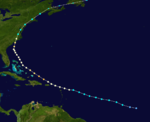
Hurricane Edouard was the strongest hurricane in the 1996 Atlantic hurricane season, reaching winds of 145 mph on its path. Edouard remained a major hurricane for eight days, an unusually long amount of time. A Cape Verde-type hurricane, the storm formed near the coast of Africa in the middle...
, Fran
Hurricane Fran
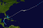
Hurricane Fran was a powerful Cape Verde-type hurricane of the 1996 Atlantic hurricane season that made landfall near Cape Fear in North Carolina at Category 3 strength. Throughout the eastern United States, early statistics on Fran reported 27 deaths and $3.2 billion in damage...
, Hortense
Hurricane Hortense
Hurricane Hortense was the eighth tropical storm, sixth hurricane, and second Category 4 hurricane of the 1996 Atlantic hurricane season. Lasting from September 3 to September 16, Hortense brought torrential flooding as it moved through the Lesser Antilles, Puerto Rico, and Dominican Republic...
, Isidore, and Lili
Hurricane Lili (1996)
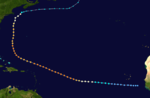
Hurricane Lili was a relatively long-lived hurricane during the very active 1996 Atlantic hurricane season. Lili formed on October 14 from a tropical wave, which emerged from the coast of west Africa on October 4. The tropical wave which developed into Lili was slow to form due to unfavorable wind...
. This timeline documents all the storm formations, strengthening, weakening, landfall
Landfall (meteorology)
Landfall is the event of a tropical cyclone or a waterspout coming onto land after being over water. When a waterspout makes landfall it is reclassified as a tornado, which can then cause damage inland...
s, extratropical transitions, as well as dissipation. The timeline also includes information that was not operationally released, meaning that information from post-storm reviews by the National Hurricane Center
National Hurricane Center
The National Hurricane Center , located at Florida International University in Miami, Florida, is the division of the National Weather Service responsible for tracking and predicting weather systems within the tropics between the Prime Meridian and the 140th meridian west poleward to the 30th...
, such as information on a storm that was not operationally warned on, has been included. The season officially began on June 1, 1996, and ended on November 30 that same year.
The season's most destructive storms were Hurricane Cesar
Hurricane Cesar-Douglas
Hurricane Cesar–Douglas was a devastating tropical cyclone that killed 122 people throughout Central and South America in late-July 1996. The Category 1 hurricane formed in late July in the Caribbean Sea and pounded Central America with rain, killing 67 people and causing local governments to deem...
, Hurricane Fran
Hurricane Fran
Hurricane Fran was a powerful Cape Verde-type hurricane of the 1996 Atlantic hurricane season that made landfall near Cape Fear in North Carolina at Category 3 strength. Throughout the eastern United States, early statistics on Fran reported 27 deaths and $3.2 billion in damage...
, and Hurricane Hortense
Hurricane Hortense
Hurricane Hortense was the eighth tropical storm, sixth hurricane, and second Category 4 hurricane of the 1996 Atlantic hurricane season. Lasting from September 3 to September 16, Hortense brought torrential flooding as it moved through the Lesser Antilles, Puerto Rico, and Dominican Republic...
. Hurricane Cesar (later known as Hurricane Douglas in the Eastern Pacific basin) was the deadliest storm of the season; it killed at least 51 people and caused severe damage in northern Colombia and southern Central America. Hurricane Fran caused $3.2 billion (1996 USD
United States dollar
The United States dollar , also referred to as the American dollar, is the official currency of the United States of America. It is divided into 100 smaller units called cents or pennies....
; $4 billion 2009 USD) worth of damage in the United States, mostly in North Carolina, and killed 26 people. Hurricane Hortense dropped torrential rainfall on southwestern Puerto Rico and the eastern Dominican Republic, killing 21 people and leaving behind $127 million (1996 USD; $174 million 2009 USD) in damage. All three storms had their names retired by the World Meteorological Organization
World Meteorological Organization
The World Meteorological Organization is an intergovernmental organization with a membership of 189 Member States and Territories. It originated from the International Meteorological Organization , which was founded in 1873...
in the spring of 1997, and were replaced with Cristobal, Fay, and Hanna for the 2002 season
2002 Atlantic hurricane season
The 2002 Atlantic hurricane season was an average Atlantic hurricane season, officially starting on June 1, 2002 and ending on November 30, dates which conventionally limit the period of each year when tropical cyclones in the Atlantic Ocean tend to form...
, respectively.
June
June 1- 12:00 am EDTEastern Time ZoneThe Eastern Time Zone of the United States and Canada is a time zone that falls mostly along the east coast of North America. Its UTC time offset is −5 hrs during standard time and −4 hrs during daylight saving time...
(0400 UTC) – The 1996 Atlantic hurricane season1996 Atlantic hurricane seasonThe 1996 Atlantic hurricane season was the first season since 1965 in which all tropical cyclones reached tropical storm status. It officially began on June 1, 1996, and lasted until November 30, 1996...
officially begins.
June 17
- 2:00 pm EDT (1600 UTC) – Tropical depression One forms near eastern Grand BahamaGrand BahamaGrand Bahama is one of the northernmost of the islands of the Bahamas, and the closest major island to the United States, lying off the state of Florida. Grand Bahama is the fifth largest island in the Bahamas island chain of approximately 700 islands and 2,400 cays...
.
June 18
- 8:00 pm EDT (0000 UTC June 19) – Tropical depression One strengthens into Tropical Storm ArthurTropical Storm Arthur (1996)Tropical Storm Arthur caused minimal flooding in the Carolinas in mid-June 1996. The first tropical cyclone and named storm of the annual Atlantic hurricane season, Arthur originated from an area of increased convection east of the Bahamas on June 16. Gradually, the system increased in...
.
June 19
- 8:00 pm EDT (0000 UTC June 20) – Tropical Storm Arthur makes landfall near Cape LookoutCape Lookout (North Carolina)This article is about the Cape Lookout in North Carolina. See Cape Lookout for other places with a similar name. Cape Lookout is southern point of the Core Banks, one of the natural barrier islands on the Atlantic coast of North Carolina, USA. delimits Onslow Bay to the west from Raleigh Bay to...
on the North CarolinaNorth CarolinaNorth Carolina is a state located in the southeastern United States. The state borders South Carolina and Georgia to the south, Tennessee to the west and Virginia to the north. North Carolina contains 100 counties. Its capital is Raleigh, and its largest city is Charlotte...
Outer BanksOuter BanksThe Outer Banks is a 200-mile long string of narrow barrier islands off the coast of North Carolina, beginning in the southeastern corner of Virginia Beach on the east coast of the United States....
with 40 mph (65 km/h)The figures for maximum sustained windMaximum sustained windThe maximum sustained winds associated with a tropical cyclone are a common indicator of the intensity of the storm. Within a mature tropical cyclone, they are found within the eyewall at a distance defined as the radius of maximum wind, or RMW. Unlike gusts, the value of these winds are...
s and position estimates are rounded to the nearest 5 units (knots, miles, or kilometers), following the convention used in the National Hurricane CenterNational Hurricane CenterThe National Hurricane Center , located at Florida International University in Miami, Florida, is the division of the National Weather Service responsible for tracking and predicting weather systems within the tropics between the Prime Meridian and the 140th meridian west poleward to the 30th...
's operational products for each storm. All other units are rounded to the nearest digit. winds.
June 20
- 8:00 am EDT (1200 UTC) – Tropical Storm Arthur weakens into a tropical depression.
June 21
- 8:00 am EDT (1200 UTC) – Tropical Depression Arthur becomes extratropical about 350 nautical miles (400 miles, 645 km) north-northeast of BermudaBermudaBermuda is a British overseas territory in the North Atlantic Ocean. Located off the east coast of the United States, its nearest landmass is Cape Hatteras, North Carolina, about to the west-northwest. It is about south of Halifax, Nova Scotia, Canada, and northeast of Miami, Florida...
.
July
July 4- 8:00 pm ASTAtlantic Standard Time ZoneThe Atlantic Standard Time Zone is a geographical region that keeps time by subtracting four hours from either Coordinated Universal Time or Greenwich Mean Time , resulting in UTC-4 or GMT-4...
(0000 UTC July 5) – Tropical depression Two forms in the south-central Atlantic basin.
July 5
- 8:00 am AST (1200 UTC) – Tropical depression Two strengthens into Tropical Storm Bertha.
- 2:00 pm AST (1800 UTC) – Tropical Storm Bertha strengthens into Hurricane BerthaHurricane Bertha (1996)Hurricane Bertha was a strong, early season major hurricane which impacted areas from the Leeward Islands to Atlantic Canada. Bertha originated from a tropical wave which moved off the eastern coast of Africa in early July. By July 3, an area of low pressure developed along the wave...
as it moves across the LeewardLeeward IslandsThe Leeward Islands are a group of islands in the West Indies. They are the northern islands of the Lesser Antilles chain. As a group they start east of Puerto Rico and reach southward to Dominica. They are situated where the northeastern Caribbean Sea meets the western Atlantic Ocean...
and VirginVirgin IslandsThe Virgin Islands are the western island group of the Leeward Islands, which are the northern part of the Lesser Antilles, which form the border between the Caribbean Sea and the Atlantic Ocean...
Islands.
July 9
- 2:00 am EDT (0600 UTC) – Hurricane Bertha reaches Category 3 intensity.
- 2:00 pm EDT (1800 UTC) – Hurricane Bertha weakens into a Category 2 hurricane.
July 10
- 2:00 am EDT (0600 UTC) – Hurricane Bertha weakens into a Category 1 hurricane.
July 12
- 8:00 am EDT (1200 UTC) – Hurricane Bertha regains Category 2 intensity.
- 4:00 pm EDT (2000 UTC) – Hurricane Bertha makes landfall between WrightsvilleWrightsville Beach, North CarolinaWrightsville Beach is a town in New Hanover County, North Carolina, United States. Wrightsville Beach is just east of Wilmington and is part of the Wilmington Metropolitan Statistical Area. The population was 2,593 at the 2000 census...
and TopsailTopsail Beach, North CarolinaTopsail Beach is a town in Pender County, North Carolina, United States. The population was 581 at the 2008 census. It is part of the Wilmington Metropolitan Statistical Area.-Geography:Topsail Beach is located at ....
Beaches in North CarolinaNorth CarolinaNorth Carolina is a state located in the southeastern United States. The state borders South Carolina and Georgia to the south, Tennessee to the west and Virginia to the north. North Carolina contains 100 counties. Its capital is Raleigh, and its largest city is Charlotte...
with 105 mph (170 km/h) winds. - 8:00 pm EDT (0000 UTC July 13) – Hurricane Bertha weakens into a Category 1 hurricane.
July 13
- 2:00 am EDT (0600 UTC) – Hurricane Bertha weakens into a tropical storm.
July 14
- 8:00 am EDT (1200 UTC) – Tropical Storm Bertha becomes extratropicalExtratropical cycloneExtratropical cyclones, sometimes called mid-latitude cyclones or wave cyclones, are a group of cyclones defined as synoptic scale low pressure weather systems that occur in the middle latitudes of the Earth having neither tropical nor polar characteristics, and are connected with fronts and...
near New BrunswickNew BrunswickNew Brunswick is one of Canada's three Maritime provinces and is the only province in the federation that is constitutionally bilingual . The provincial capital is Fredericton and Saint John is the most populous city. Greater Moncton is the largest Census Metropolitan Area...
.
July 24

- 2:00 pm AST (1800 UTC) – Tropical depression Three forms just north of Isla MargaritaIsla MargaritaMargarita Island is the largest island of the state of Nueva Esparta in Venezuela, situated in the Caribbean Sea, off the northeastern coast of the country. The state also contains two other smaller islands: Coche and Cubagua. The capital city of Nueva Esparta is La Asunción, located in a river...
.
July 25
- 8:00 am EDT (1200 UTC) – Tropical depression Three strengthens into Tropical Storm Cesar.
July 27
- 8:00 am EDT (1200 UTC) – Tropical Storm Cesar strengthens into Hurricane CesarHurricane Cesar-DouglasHurricane Cesar–Douglas was a devastating tropical cyclone that killed 122 people throughout Central and South America in late-July 1996. The Category 1 hurricane formed in late July in the Caribbean Sea and pounded Central America with rain, killing 67 people and causing local governments to deem...
.
July 28
- 12:00 am EDT (0400 UTC) – Hurricane Cesar makes landfall just north of BluefieldsBluefieldsBluefields is the capital of the municipality of the same name, and of Región Autónoma del Atlántico Sur in Nicaragua. It was also capital of the former Zelaya Department, which was divided into North and South Atlantic Autonomous Regions...
, NicaraguaNicaraguaNicaragua is the largest country in the Central American American isthmus, bordered by Honduras to the north and Costa Rica to the south. The country is situated between 11 and 14 degrees north of the Equator in the Northern Hemisphere, which places it entirely within the tropics. The Pacific Ocean...
, with 85 mph (135 km/h) winds. - 8:00 am EDT (1200 UTC) – Hurricane Cesar weakens into a tropical storm.
- 7:00 pm CDT (0000 UTC July 29) – Tropical Storm Cesar completes its trek across Nicaragua, and becomes Tropical Storm Douglas in the Eastern Pacific.
August
August 19- 2:00 am EDTEastern Time ZoneThe Eastern Time Zone of the United States and Canada is a time zone that falls mostly along the east coast of North America. Its UTC time offset is −5 hrs during standard time and −4 hrs during daylight saving time...
(0600 UTC) – Tropical depression Four forms in the northwestern Caribbean SeaCaribbean SeaThe Caribbean Sea is a sea of the Atlantic Ocean located in the tropics of the Western hemisphere. It is bounded by Mexico and Central America to the west and southwest, to the north by the Greater Antilles, and to the east by the Lesser Antilles....
. - 2:00 pm EDT (1800 UTC) – Tropical depression Four strengthens into Tropical Storm Dolly.
- 2:00 pm AST (1800 UTC) – Tropical depression Five forms about 100 miles (160 km) west of the SenegalSenegalSenegal , officially the Republic of Senegal , is a country in western Africa. It owes its name to the Sénégal River that borders it to the east and north...
/Guinea-BissauGuinea-BissauThe Republic of Guinea-Bissau is a country in West Africa. It is bordered by Senegal to the north, and Guinea to the south and east, with the Atlantic Ocean to its west....
border.
August 20
- 12:30 pm CDT (1730 UTC) – Tropical Storm Dolly strengthens into Hurricane DollyHurricane Dolly (1996)Hurricane Dolly was a Category 1 hurricane that struck Mexico. The storm killed 14 people and left many homeless. The fourth named storm and the third hurricane of the 1996 Atlantic hurricane season, Dolly developed from a tropical wave in the west-central Caribbean Sea on August 19...
as it makes its first landfall near Punta Herrero, MexicoMexicoThe United Mexican States , commonly known as Mexico , is a federal constitutional republic in North America. It is bordered on the north by the United States; on the south and west by the Pacific Ocean; on the southeast by Guatemala, Belize, and the Caribbean Sea; and on the east by the Gulf of...
with 75 mph (120 km/h) winds. - 7:00 pm CDT (0000 UTC August 21) – Hurricane Dolly weakens into a tropical storm.
August 21
- 7:00 am CDT (1200 UTC) – Tropical Storm Dolly weakens into a tropical depression.
- 7:00 pm CDT (0000 UTC August 22) – Tropical Depression Dolly regains tropical storm status.
August 22
- 2:00 am AST (0600 UTC) – Tropical depression Five, which formed about 100 miles (160 km) west of the Senegal/Guinea-Bissau border on August 19, strengthens into Tropical Storm Edouard.
August 23
- 7:00 am CDT (1200 UTC) – Tropical Storm Dolly regains hurricane status as it makes its second landfall midway between Tampico, Tamaulipas, and Tuxpan, Veracruz, with 80 mph (130 km/h) winds.
- 8:00 am AST (1200 UTC) – Tropical Storm Edouard strengthens into Hurricane EdouardHurricane Edouard (1996)Hurricane Edouard was the strongest hurricane in the 1996 Atlantic hurricane season, reaching winds of 145 mph on its path. Edouard remained a major hurricane for eight days, an unusually long amount of time. A Cape Verde-type hurricane, the storm formed near the coast of Africa in the middle...
. - 8:00 am AST (1200 UTC) – Tropical depression Six forms just southeast of the Cape VerdeCape VerdeThe Republic of Cape Verde is an island country, spanning an archipelago of 10 islands located in the central Atlantic Ocean, 570 kilometres off the coast of Western Africa...
Islands. - 1:00 pm CDT (1800 UTC) – Hurricane Dolly weakens into a tropical storm.
- 7:00 pm CDT (0000 UTC August 24) – Tropical Storm Dolly weakens into a tropical depression.
August 24
- 8:00 am AST (1200 UTC) – Hurricane Edouard reaches Category 2 intensity.
- 2:00 pm AST (1800 UTC) – Hurricane Edouard reaches Category 3 intensity.
- 8:00 pm AST (0000 UTC August 25) – Hurricane Edouard reaches Category 4 intensity.
August 25
- 12:00 am MDTMountain Time ZoneThe Mountain Time Zone of North America keeps time by subtracting seven hours from Coordinated Universal Time, also known as Greenwich Mean Time, during the shortest days of autumn and winter , and by subtracting six hours during daylight saving time in the spring, summer, and early autumn...
(0600 UTC) – Tropical Depression Dolly dissipates over the eastern North Pacific Ocean. - 2:00 am AST (0600 UTC) – Hurricane Edouard reaches its peak intensity of 145 mph (230 km/h) winds and a pressure of 933 mbar, making it the strongest storm of the season.
- 8:00 pm AST (0000 UTC August 26) – Tropical depression Seven forms south of the Cape Verde Islands.
August 27
- 8:00 am AST (1200 UTC) – Tropical depression Six strengthens into Tropical Storm Fran.
August 28
- 2:00 am AST (0600 UTC) – Tropical depression Seven strengthens into Tropical Storm Gustav.
- 8:00 am AST (1200 UTC) – Hurricane Edouard weakens into a Category 3 hurricane.
August 29
- 8:00 am EDT (1200 UTC) – Hurricane Edouard regains Category 4 intensity.
- 8:00 pm AST (0000 UTC August 30) – Tropical Storm Fran strengthens into Hurricane FranHurricane FranHurricane Fran was a powerful Cape Verde-type hurricane of the 1996 Atlantic hurricane season that made landfall near Cape Fear in North Carolina at Category 3 strength. Throughout the eastern United States, early statistics on Fran reported 27 deaths and $3.2 billion in damage...
.
August 30
- 2:00 pm AST (1800 UTC) – Hurricane Fran weakens into a tropical storm.
- 8:00 pm EDT (0000 UTC August 31) – Hurricane Edouard weakens back into a Category 3 hurricane.
August 31
- 8:00 am AST (1200 UTC) – Tropical Storm Fran regains hurricane status.
September

- 8:00 am EDT (1200 UTC) – Hurricane Edouard weakens into a Category 2 hurricane.
- 2:00 pm AST (1800 UTC) – Tropical Storm Gustav weakens into a tropical depression.
- 8:00 pm EDT (0000 UTC September 2) – Hurricane Edouard weakens into a Category 1 hurricane.
September 2
- 2:00 am AST (0600 UTC) – Tropical Depression Gustav dissipates.
- 8:00 pm EDT (0000 UTC September 3) – Hurricane Edouard weakens into a tropical storm.
September 3
- 2:00 am EDT (0600 UTC) – Tropical Storm Edouard becomes extratropical about 100 miles (160 km) south-southeast of the MaineMaineMaine is a state in the New England region of the northeastern United States, bordered by the Atlantic Ocean to the east and south, New Hampshire to the west, and the Canadian provinces of Quebec to the northwest and New Brunswick to the northeast. Maine is both the northernmost and easternmost...
/CanadaCanadaCanada is a North American country consisting of ten provinces and three territories. Located in the northern part of the continent, it extends from the Atlantic Ocean in the east to the Pacific Ocean in the west, and northward into the Arctic Ocean...
. - 8:00 am AST (1200 UTC) – Tropical depression Eight forms about midway between the northern Leeward IslandsLeeward IslandsThe Leeward Islands are a group of islands in the West Indies. They are the northern islands of the Lesser Antilles chain. As a group they start east of Puerto Rico and reach southward to Dominica. They are situated where the northeastern Caribbean Sea meets the western Atlantic Ocean...
and SenegalSenegalSenegal , officially the Republic of Senegal , is a country in western Africa. It owes its name to the Sénégal River that borders it to the east and north...
. - 2:00 pm EDT (1800 UTC) – Hurricane Fran reaches Category 2 intensity.
September 4
- 2:00 am EDT (0600 UTC) – Hurricane Fran reaches Category 3 intensity.
September 5
- 8:30 pm EDT (0030 UTC September 6) – Hurricane Fran makes landfall near Cape Fear, North CarolinaNorth CarolinaNorth Carolina is a state located in the southeastern United States. The state borders South Carolina and Georgia to the south, Tennessee to the west and Virginia to the north. North Carolina contains 100 counties. Its capital is Raleigh, and its largest city is Charlotte...
with 115 mph (185 km/h) winds.
September 6
- 2:00 am EDT (0600 UTC) – Hurricane Fran rapidly weakens to a Category 1 hurricane.
- 8:00 am EDT (1200 UTC) – Hurricane Fran weakens into a tropical storm.
- 2:00 pm EDT (1800 UTC) – Tropical Storm Fran weakens into a tropical depression.
September 7
- 2:00 am AST (0600 UTC) – Tropical depression Eight strengthens into Tropical Storm Hortense.
September 8
- 8:00 pm EDT (0000 UTC September 9) – Tropical Depression Fran becomes extratropical in southern OntarioOntarioOntario is a province of Canada, located in east-central Canada. It is Canada's most populous province and second largest in total area. It is home to the nation's most populous city, Toronto, and the nation's capital, Ottawa....
.
September 9

- 2:00 am AST (0600 UTC) – Tropical Storm Hortense strengthens into Hurricane HortenseHurricane HortenseHurricane Hortense was the eighth tropical storm, sixth hurricane, and second Category 4 hurricane of the 1996 Atlantic hurricane season. Lasting from September 3 to September 16, Hortense brought torrential flooding as it moved through the Lesser Antilles, Puerto Rico, and Dominican Republic...
.
September 10
- 2:00 am EDT (0600 UTC) – Hurricane Hortense makes its first landfall near Guánica, Puerto RicoGuánica, Puerto RicoGuánica is a municipality in southwestern Puerto Rico located on southern coast, bordering the Caribbean Sea, south of Sabana Grande, east of Lajas, and west of Yauco. It is part of the Yauco Metropolitan Statistical Area....
with 80 mph (130 km/h) winds.
September 11
- 8:00 am EDT (1200 UTC) – Hurricane Hortense reaches Category 2 intensity.
- 8:00 pm EDT (0000 UTC September 12) – Hurricane Hortense reaches Category 3 intensity.
September 12
- 8:00 am EDT (1200 UTC – Hurricane Hortense reaches Category 4 intensity.
September 13
- 8:00 am EDT (1200 UTC) – Hurricane Hortense weakens into a Category 3 hurricane.
- 8:00 pm EDT (0000 UTC September 14) – Hurricane Hortense weakens into a Category 2 hurricane.
September 14
- 2:00 pm AST (1800 UTC) – Hurricane Hortense weakens into a Category 1 hurricane.
- 11:00 pm AST (0300 UTC September 15) – Hurricane Hortense makes its second landfall in Nova ScotiaNova ScotiaNova Scotia is one of Canada's three Maritime provinces and is the most populous province in Atlantic Canada. The name of the province is Latin for "New Scotland," but "Nova Scotia" is the recognized, English-language name of the province. The provincial capital is Halifax. Nova Scotia is the...
with 80 mph (130 km/h) winds.
September 15
- 8:00 am AST (1200 UTC) – Hurricane Hortense weakens into a tropical storm.
- 2:00 pm AST (1800 UTC) – Tropical Storm Hortense becomes extratropical just south of Newfoundland.
September 24
.jpg)
- 8:00 am AST (1200 UTC) – Tropical depression Nine forms about 150 miles (240 km) south of Santiago, Cape VerdeSantiago, Cape VerdeSantiago , or Santiagu in Cape Verdean Creole, is the largest island of Cape Verde, its most important agricultural centre and home to half the nation’s population. At the time of Darwin's voyage it was called St. Jago....
.
September 25
- 2:00 am AST (0600 UTC) – Tropical depression Nine strengthens into Tropical Storm Isidore.
September 26
- 2:00 am AST (0600 UTC) – Tropical Storm Isidore strengthens into Hurricane Isidore.
September 27
- 2:00 am AST (0600 UTC) – Hurricane Isidore reaches Category 2 intensity.
- 8:00 pm AST (0000 UTC September 28) – Hurricane Isidore reaches Category 3 intensity.
September 28
- 8:00 am AST (1200 UTC) – Hurricane Isidore weakens into a Category 2 hurricane.
September 29
- 2:00 am AST (0600 UTC) – Hurricane Isidore weakens into a Category 1 hurricane.
- 8:00 pm AST (0000 UTC September 30) – Hurricane Isidore weakens into a tropical storm.
October
October 1- 8:00 am AST (1200 UTC) – Tropical Storm Isidore weakens into a tropical depression.
- 8:00 pm AST (0000 UTC October 2) – Tropical Depression Isidore becomes extratropical.
October 4
.gif)
- 1:00 pm CDT (1800 UTC) – Tropical Depression Ten forms about 70 miles (110 km) east of the TamaulipasTamaulipasTamaulipas officially Estado Libre y Soberano de Tamaulipas is one of the 31 states which, with the Federal District, comprise the 32 Federal Entities of Mexico. It is divided in 43 municipalities and its capital city is Ciudad Victoria. The capital city was named after Guadalupe Victoria, the...
/VeracruzVeracruzVeracruz, formally Veracruz de Ignacio de la Llave officially Estado Libre y Soberano de Veracruz de Ignacio de la Llave , is one of the 31 states that, along with the Federal District, comprise the 32 federative entities of Mexico. It is divided in 212 municipalities and its capital city is...
border.
October 6
- 1:00 pm CDT (1800 UTC) – Tropical Depression Ten strengthens into Tropical Storm JosephineTropical Storm Josephine (1996)Tropical Storm Josephine was the tenth named storm of a moderately active 1996 Atlantic hurricane season. A strong tropical storm, Josephine dumped heavy rain across most of the southeastern and eastern United States killing two people and leaving $130 million dollars in...
.
October 7
- 11:30 pm EDT (0330 UTC October 8) – Tropical Storm Josephine makes landfall in Taylor County, FloridaTaylor County, FloridaTaylor County is a county located in the state of Florida. As of 2000, the population was 19,256. The U.S. Census Bureau 2005 estimate for the county was 19,622 . Its county seat is Perry, Florida.- History :Taylor County was created in 1856...
, with 70 mph (110 km/h) winds.
October 8
- 2:00 am EDT (0600 UTC) – Tropical Storm Josephine becomes extratropical along the GeorgiaGeorgia (U.S. state)Georgia is a state located in the southeastern United States. It was established in 1732, the last of the original Thirteen Colonies. The state is named after King George II of Great Britain. Georgia was the fourth state to ratify the United States Constitution, on January 2, 1788...
/FloridaFloridaFlorida is a state in the southeastern United States, located on the nation's Atlantic and Gulf coasts. It is bordered to the west by the Gulf of Mexico, to the north by Alabama and Georgia and to the east by the Atlantic Ocean. With a population of 18,801,310 as measured by the 2010 census, it...
border.
October 11
- 8:00 am EDT (1200 UTC) – Tropical depression Eleven forms about midway between BelizeBelizeBelize is a constitutional monarchy and the northernmost country in Central America. Belize has a diverse society, comprising many cultures and languages. Even though Kriol and Spanish are spoken among the population, Belize is the only country in Central America where English is the official...
and Great Swan Island. - 2:00 pm EDT (1800 UTC) – Tropical depression Eleven strengthens into Tropical Storm Kyle.
October 12
- 7:00 am CDT (1200 UTC) – Tropical Storm Kyle weakens into a tropical depression.
- 1:00 pm CDT (1800 UTC) – Tropical Depression Kyle makes landfall near the GuatemalaGuatemalaGuatemala is a country in Central America bordered by Mexico to the north and west, the Pacific Ocean to the southwest, Belize to the northeast, the Caribbean to the east, and Honduras and El Salvador to the southeast...
/HondurasHondurasHonduras is a republic in Central America. It was previously known as Spanish Honduras to differentiate it from British Honduras, which became the modern-day state of Belize...
border with 30 mph (50 km/h) winds. - 7:00 pm CDT (0000 UTC October 13) – Tropical Depression Kyle dissipates near where it made landfall.
October 14
- 8:00 am EDT (1200 UTC) – Tropical depression Twelve forms just east of NicaraguaNicaraguaNicaragua is the largest country in the Central American American isthmus, bordered by Honduras to the north and Costa Rica to the south. The country is situated between 11 and 14 degrees north of the Equator in the Northern Hemisphere, which places it entirely within the tropics. The Pacific Ocean...
.
October 16
- 2:00 am EDT (0600 UTC) – Tropical depression Twelve strengthens into Tropical Storm Lili.
October 17
- 8:00 am EDT (1200 UTC) – Tropical Storm Lili strengthens into Hurricane LiliHurricane Lili (1996)Hurricane Lili was a relatively long-lived hurricane during the very active 1996 Atlantic hurricane season. Lili formed on October 14 from a tropical wave, which emerged from the coast of west Africa on October 4. The tropical wave which developed into Lili was slow to form due to unfavorable wind...
.
October 18
- 5:30 am EDT (0930 UTC) – Hurricane Lili reaches Category 2 intensity and makes landfall on the Zapata PeninsulaZapata PeninsulaZapata Peninsula is a large peninsula in Matanzas Province, southern Cuba, at . Ciénaga de Zapata National Park is located on the peninsula....
with 100 mph (160 km/h) winds. - 2:00 pm EDT (1800 UTC) – Hurricane Lili weakens into a Category 1 hurricane.
- 8:00 pm EDT (0000 UTC October 19) – Hurricane Lili regains Category 2 intensity.
October 19
- 8:00 am EDT (1200 UTC) – Hurricane Lili reaches Category 3 intensity.
- 2:00 pm EDT (1800 UTC) – Hurricane Lili weakens into a Category 2 hurricane.
- 8:00 pm EDT (0000 UTC October 20) – Hurricane Lili weakens into a Category 1 hurricane.
October 20
- 8:00 am AST (1200 UTC) – Hurricane Lili regains Category 2 intensity.
- 2:00 pm AST (1800 UTC) – Hurricane Lili weakens into a Category 1 hurricane.
October 25
- 8:00 am AST (1200 UTC) – Hurricane Lili regains Category 2 intensity.
- 2:00 pm AST (1800 UTC) – Hurricane Lili weakens into a Category 1 hurricane.
October 26
- 2:00 pm AST (1800 UTC) – Hurricane Lili weakens into a tropical storm.
October 27
- 1:00 am AST (0600 UTC) – Tropical Storm Lili becomes extratropical about 300 nautical miles (345 miles, 550 km) north-northwest of the AzoresAzoresThe Archipelago of the Azores is composed of nine volcanic islands situated in the middle of the North Atlantic Ocean, and is located about west from Lisbon and about east from the east coast of North America. The islands, and their economic exclusion zone, form the Autonomous Region of the...
.
November
November 16- 1:00 pm EST (1800 UTC) – Tropical depression Thirteen forms south of JamaicaJamaicaJamaica is an island nation of the Greater Antilles, in length, up to in width and 10,990 square kilometres in area. It is situated in the Caribbean Sea, about south of Cuba, and west of Hispaniola, the island harbouring the nation-states Haiti and the Dominican Republic...
.
November 19
- 1:00 am EST (0600 UTC) – Tropical depression Thirteen strengthens into Tropical Storm Marco.
November 20
- 1:00 am EST (0600 UTC) – Tropical Storm Marco strengthens into Hurricane MarcoHurricane Marco (1996)Hurricane Marco was a Category 1 hurricane which caused flooding and mudslides in parts of the Caribbean. The 13th named storm of the 1996 Atlantic hurricane season, Marco developed in the southwestern Caribbean between Jamaica and Honduras on November 16. It attained tropical storm strength...
. - 1:00 pm EST (1800 UTC) – Hurricane Marco weakens into a tropical storm.
November 23
- 1:00 pm EST (1800 UTC) – Tropical Storm Marco weakens into a tropical depression.
November 24
- 7:00 am EST (1200 UTC) – Tropical Depression Marco regains tropical storm status.
November 26
- 7:00 am EST (1200 UTC) – Tropical Storm Marco weakens into a tropical depression.
- 1:00 pm EST (1800 UTC) – Tropical Depression Marco dissipates about 100 miles (160 km) southwest of the Isle of YouthIsle of YouthIsla de la Juventud is the second-largest Cuban island and the seventh-largest island in the West Indies . The island has an area and is 100 km south of the island of Cuba, across the Gulf of Batabanó...
.
November 30
- 11:59 pm EST (0359 UTC) – The 1996 Atlantic hurricane season1996 Atlantic hurricane seasonThe 1996 Atlantic hurricane season was the first season since 1965 in which all tropical cyclones reached tropical storm status. It officially began on June 1, 1996, and lasted until November 30, 1996...
officially ends.