
Sylt
Encyclopedia
Sylt (ˈzʏlt; ; Söl'ring North Frisian
: Söl' ) is an island in northern Germany
, part of Nordfriesland
district, Schleswig-Holstein
, and well known for the distinctive shape of its shoreline. It belongs to the North Frisian Islands
and is the largest island in North Frisia
. The northernmost island of Germany, it is known for its tourist resorts, notably Westerland, Kampen
and Wenningstedt-Braderup
, as well as for its 40 km long sandy beach. It is frequently covered by the media in connection with its exposed situation in the North Sea
and its ongoing loss of land during storm tides. Since 1927, Sylt has been connected to the mainland by the Hindenburgdamm
causeway.
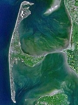
 With 99.14 km², Sylt is the fourth-largest German island and the largest North Sea
island. Sylt is situated at 9 to 16 km off the mainland, being connected there by the Hindenburgdamm. Southeast of Sylt the islands Föhr
and Amrum
are located, to the north lies the Danish
island Rømø
. The island of Sylt extends for 38 km in a north-south direction and on its northern peak at Königshafen is only 320 m wide. Its widest distance, from the town of Westerland in the west to the eastern Nössespitze near Morsum, measures 12.6 km. On the western and northwestern shore a 40 km sand beach is located, east of Sylt the Wadden Sea
is situated, which belongs to the Schleswig-Holstein Wadden Sea National Park
and mostly falls dry during low tide
.
The island's shape has constantly shifted over time, a process which is still ongoing today. The northern and southern spits
of Sylt are exclusively made up of unfertile sand deposits, while the central part with the municipalities of Westerland, Wenningstedt-Braderup
and Sylt-Ost
consists of a geestland
core, which becomes apparent in the form of the Red Cliff of Wenningstedt. The geestland facing the Wadden Sea gradually turns into fertile marshland around Sylt-Ost. Today sources show that Sylt has only been an island since the Grote Mandrenke
flood of 1362. The so called Uwe-Düne (Uwe Dune) is the island's highest elevation with 52.5 m above sea level.
On Sylt a marine climate influenced by the Gulf stream
is predominant. With an average of 2 °C, winter months are slightly milder than on the mainland, summer months though with a median of 17 °C are somewhat cooler, despite a longer sunshine period on Sylt. The annual average sunshine period of Sylt is 4.4 hours per day. It is due to the low relief of the shoreline that Sylt had a total of 1899 hours of sunshine in 2005, 180 hours above the German average. Clouds cannot accumulate as quickly and are generally scattered by the constant westerly or northwesterly winds.
The annual mean temperature is 8.5 °C. The annually averaged wind speed measures 6.7 m/s, predominantly from western directions. The annual rainfall amounts to about 650 millimetres. Since 1937 weather data are collected at Deutscher Wetterdienst's northernmost station on a dune near List, which has meanwhile become automated. A number of commercial meteorological services like Meteomedia AG
operate stations in List too.
The island in its current form has only existed for about 400 years. Like the mainland geestland
, it was formed of moraine
s from the older ice age
s, thus being made up of a till
core, which is now apparent in the island's west and centre by the cliff, dunes and beach. This sandy core began to erode
as it was exposed to a strong current along the island's steep basement when the sea level rose 8000 years ago. During the process, sediment
s were accumulated north and south of the island. The west coast, which was originally situated 10 km off today's shore, was thus gradually moved eastward, while at the same time the isle began to extend to the north and south. After the ice ages, marshland began to form around this geestland core.
In 1141, Sylt is recorded as an island, yet before the Grote Mandrenke
flood it belonged to a landscape cut by tidal creeks and at least during low tide it could be reached by foot. Only after this flood, the creation of a spit
from sediments began to form the current characteristical shape of Sylt. Thereby mainly the northern and southern edges of Sylt were and still are the subject of great change. E.g. Listland was separated from the rest of the island in the 14th century and from the later 17th century on, the Königshafen (King's Harbour) began to silt up as the "elbow" spit began to form.
In addition to the constant loss of land, the inhabitants during the Little Ice Age
were strained by sand drift. Dunes shifting to the east threatened settlements and arable land and had to be stopped by the planting of marram grass
in the 18th century. Consequently though, material breaking off the island was increasingly washed away and the island's substance continued to decrease.
Record of the annual land loss exist since 1870. According to them, Sylt lost an annual 0.4 m of land in the north and 0.7 m in the south from 1870 to 1951. From 1951 to 1984, the ratio increased while to 0.9 and 1.4 m respectively, while shorelines at the island's very edges at Hörnum and List are even more affected.
Severe storm surges of the last decades have repeatedly endagered Sylt to the edge of breaking in two, e.g. Hörnum was temporarily cut off the island in 1962. Part of the island near Rantum which is only 500m wide is especially threatened.
 Measures of protection
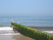
against the continuous erosion date back to the early 19th century when groyne
s of wooden poles were constructed. Those were built rectangular into the sea from the coast line. Later they were replaced by metal and eventually by armoured concrete groynes. The constructions did not have the desired effect though to stop the erosion caused by crossways currents. "Leeward
erosion", i.e. erosion on the downwind side of the groynes prevented sustainable accumulation of sand.
In the 1960s it was tried to break the power of the sea by installing tetrapods
along the groyne bases or by putting them into the sea like groynes. The four-fingered structures, built in France, were too heavy for Sylt's beaches with tons of weight and were equally unable to prevent erosion. Therefore they were removed from the Hörnum west beach in 2005.
Since the early 1970s the only effective means so far has been flushing sand onto the shore. Dredging vessels use to pump a mixture of sand and water to a beach where it is spread by bulldozers. Thus storm floods will only erase the artificial storage of sand, while the shoreline proper remains intact and erosion is slowed down. This procedure causes considerable costs. The required budget of an annual €
10 million is currently provided by federal German, Schleswig-Holstein state and EU funds. Since 1972 an estimated 35.5 million cubic metres of sand have been flushed ashore and dumped on Sylt. The measures have so far cost more than €134 million in total, but according to scientific calculations they are sufficient to prevent greater loss of land for at least three decades, so the benefits for the island's economic power and for the economically underdeveloped region in general would outweigh the costs. In the 1995 study Klimafolgen für Mensch und Küste am Beispiel der Nordseeinsel Sylt (Climate impact for Man and Shores as seen on the North Sea island Sylt) it reads: "Hätte Sylt nicht das Image einer attraktiven Ferieninsel, gäbe es den Küstenschutz in der bestehenden Form gewiss nicht" (If Sylt did not have the image of an attractive holiday island, coastal management in its current form would certainly not exist).
The enforcement of a natural reef
off Sylt is being discussed as an alternative solution. A first experiment was conducted from 1996 to 2003. A sand drainage as being successfully used on Danish islands is not likely to work on Sylt owing to the underwater slope here.
Parallelly to the ongoing sand flushing, the deliberate demolition of groynes has begun amid great effort at certain beach sections where they were proven largely ineffective. This measure also terminated the presumably most famous groyne of Sylt, Buhne 16 — the namesake of the local nude beach.
A number of experts, however, fears that Sylt will still have to face considerable losses of land until the mid 21st century. The continuous global warming
is thought to result in increasing storm activity, which would result in increased land loss and, as a first impact, might mean the end for property insurances. Measurements showed that, unlike in former times, the wave energy of the sea is not any more consumed off the beach, today it carries its destructive effects on to the beaches proper. This will result in an annual loss of sand of 1.1 million m³.
The dunes of the island constitute nature reserve
s and may only be entered on marked tracks. So called "wild paths" promote erosion and are not to be followed. Where vegetation is tread upon and no roots are left to hold the sand, it will be removed by wind and water.
The Wadden Sea
on the east side between Sylt and the mainland is nature reserve and bird sanctuary since 1935 and is part of the Schleswig-Holstein Wadden Sea National Park. The construction of breakwaters in this area shall abate sedimentation and is used for land reclamation
.
Also the grazing of sheep on the sea dikes and heaths of Sylt eventually serves coastal management, since the animals keep the vegetation short and compress the soil with their hooves. Thus they help create a denser dike surface, which in case of storm surges provides less area for the waves to impact.
 The flora
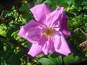
of Sylt is shaped by the island's original sparingness. Until the mid 19th century Sylt was an island almost completely devoid of trees, only artificial plantations created small areas of forest and bush. Still today one can recognize the devised structure of the Friedrichshain and Südwäldchen forests in Westerland, the trees are mostly standing in rank and file. Also the now widespread Rosa rugosa, known as "Sylt rose" on the island was only imported to Sylt. It originates from the Kamchatka peninsula in Siberia
. The undemanding rose met ideal conditions on Sylt and spread so quickly that it is now a common sight on the island. Its proliferation is viewed critically from a biological point of view, since it threatens to displace endangered local species, especially on the heaths.
The ample heaths
on the eastern side of the island provide habitats for many rare species of plants and animals which are adapted to the extreme conditions like drought, warmth, wind. About 2,500 animal species and 150 species of plants have so far been recorded. 45% of those plants are on the IUCN Red List
. Especially notable are the 600 species of butterflies
that live in the heaths, Small Tortoiseshell
, Brimstone
, Painted Lady
and Peacock butterfly
among them.
With several thousand individuals in the dune belt of Sylt, the Natterjack Toad
, endangered in Germany, has one of Germany's largest habitats here. Their spawning places are wettened dune slacks and shallow, short-lived pools.For a living they prefer sandy areas with vegetation. The main threat for this species on Sylt is road traffic.
The many water bird
s and other coastal avians, that have their hatching grounds on Sylt or use the island for resting on their migrations constitute an ornithological
feature. There are two notable hatching areas on Sylt, the Königshafen bay with the small island Uthörn
in the north and the Rantum basin in the southeast. Birds that use to hatch on Sylt include Black-headed Gull
, Arctic Tern
, Pied Avocet
, Common Redshank
, Common Gull
, Oystercatcher
, Northern Lapwing
, Common Shelduck
and Tufted Duck
. During the migration, Sylt is a resting spot for thousands of Brent Goose
s and Shelducks, Eurasian Wigeons and Common Eider
s, as well as Bar-tailed Godwit
, Red knot
s, Dunlin
s and Eurasian Golden Plover
s. Ringed Plover
, Common Snipe
, Ruff
and other species are less common visitors to the island.
Concerning land mammal
s, there is no significant deviation from the neighbouring areas of mainland Nordfriesland. Primarily European Hare
, Rabbit
and Roe deer
can be found and are also hunted as game on the island. When the island was connected to the mainland by the causeway, also fox
and badger
became common.
West of Sylt a breeding area of Harbour Porpoise
s is located. In addition, great numbers of Harbour Seals and Grey Seal
s, the latters being rather uncommon in German seas, can be found on sand banks off Sylt.
Numerous associations and societies that care for the exploration and the protection of endangered animals and plants have their branches on Sylt. Among them are the Alfred-Wegener-Institute for Polar and Marine Research, Verein Jordsand and Wadden Sea Conservation Station
. Also the Federal Office for the Environment operates a research station in the dunes at Westerland.
with its seat in Keitum administrates all municipalities on the island, save for the independent town of Westerland. As of December 2007, Sylt had 21,190 inhabitants, 9,072 of whom living in Westerland. These numbers do not include owners of summer residences.
A referendum held in May 2008 decided for the merger of the Sylt-Ost
municipality with the town of Westerland due 1 January 2009. Various groups of interest are thereby striving for a fusion of all municipalities on the island into a single governing body.
. On its eastern shore, a harbour is located where, in addition to tourist ships, the "Sylt-Express" ferry-boat sails to Havneby on the Danish island Rømø
. Wenningstedt
together with Braderup and Kampen
used to form the Norddörfer (Northern Villages) municipality, an early intercommunal association, which partly remains today in form of a school union. While Kampen, mainly in the 1950s and 1960s was famous in Germany for attracting celebrities, Wenningstedt is known as a "family resort" for more than 100 years. Since 1855, the prominent black and white Kampen lighthouse
is located between Kampen and Wenningstedt, it is the oldest one on the island. East of there, the "Braderuper Heide" nature reserve is situated. Right south of Wenningstedt are the town limits of the island's metropolis, Westerland.
After the complete destruction of the village Eidum by a storm surge on 1 November 1436, the survivors founded a new village northeast of their old home: Westerland. The name was first recorded in 1462. In 1865 a seaside spa was founded, 50 years later Westerland was granted town privileges
. In 1949 it was finally officially recognised as a health resort. In 2007, the town counted 9,072 citizens.
South of Westerland, the island extends for about 15 km in the form of a spit, until it is cut by the Hörnumtief tidal creek, that runs through the Wadden Sea mudflats east of Sylt. Here is the location of Rantum
. This village, like no other on Sylt, had to fight sand drift during the past centuries. Many farmsteads and a church had to be abandoned because of shifting dunes moving eastward. Only the planting of marram grass
stopped the dunes and put an end to this threat. To the east there are a few scattered spots of marshland, while the area is mostly coined by dunes.
Hörnum
on the island's southern headland is the youngest village, having been founded shortly after 1900. But already in former times the uninhabited southern tip of Sylt was said to serve as refuge for pirates and fishermen. The name Budersand in the area emanates from that custom, marking a great dune where booths stood in former times to serve as shelters. This southern headland, called Odde, is marked by continuous loss of land. Each year great amounts of sand are washed away by storm floods and coastal management has not yet seen sustainable effects in the area, so that further losses have to be expected.
, a causeway
with a railway line on top. The passenger trains connect Westerland to Niebüll
or Klanxbüll
, and there is also the option of taking one's car onto the train at Niebüll. Furthermore, Ferry services to the nearby Danish
island of Rømø
exist. Beyond, Sylt Airport
serves the region.
. It has its own dialect, Söl'ring
, which is the indigenous speech of Sylt. Söl'ring is a unique dialect of insular North Frisian
, with elements of Danish
, Dutch
and English
. Today, only a small fraction of the population still speaks Söl'ring. A law to promote the language („Friesisch-Gesetz“) was passed in 2004. The northernmost part of the island, Listland, was traditionally Danish-speaking.
As in many areas in Schleswig-Holstein
on New Year's Eve
, groups of children go masked from house to house, reciting poems. This is known as "Rummelpottlaufen", and as a reward, children receive sweets and/or money.
Sylt also has unique Frisian-style houses.
Today, Sylt is mainly a tourist attraction, famous for its healthy climate, and the many German celebrities who own houses on the island. The beach even has a nude section.
Söl'ring
Söl'ring is the dialect of the North Frisian language spoken on the island of Sylt in the German region of North Frisia. Söl'ring refers to the Söl'ring Frisian word for Sylt, Söl. Together with the Fering, Öömrang, and Heligolandic dialects, it forms part of the insular group of North Frisian...
: Söl' ) is an island in northern Germany
Germany
Germany , officially the Federal Republic of Germany , is a federal parliamentary republic in Europe. The country consists of 16 states while the capital and largest city is Berlin. Germany covers an area of 357,021 km2 and has a largely temperate seasonal climate...
, part of Nordfriesland
Nordfriesland
Nordfriesland, English "Northern Friesland" or "North Frisia", is a district in Schleswig-Holstein, Germany. It includes almost all of traditional North Frisia along with adjacent areas to the east and south and is bounded by the districts of Schleswig-Flensburg and Dithmarschen, the North Sea and...
district, Schleswig-Holstein
Schleswig-Holstein
Schleswig-Holstein is the northernmost of the sixteen states of Germany, comprising most of the historical duchy of Holstein and the southern part of the former Duchy of Schleswig...
, and well known for the distinctive shape of its shoreline. It belongs to the North Frisian Islands
North Frisian Islands
The North Frisian Islands are a group of islands in the Wadden Sea, a part of the North Sea, off the western coast of Schleswig-Holstein, Germany. The German islands are in the traditional region of North Frisia and are part of the Schleswig-Holstein Wadden Sea National Park and the Kreis of...
and is the largest island in North Frisia
North Frisia
North Frisia or Northern Friesland is the northernmost portion of Frisia, located primarily in Germany between the rivers Eider and Wiedau/Vidå. It includes a number of islands, e.g., Sylt, Föhr, Amrum, Nordstrand, and Heligoland.-History:...
. The northernmost island of Germany, it is known for its tourist resorts, notably Westerland, Kampen
Kampen, Germany
Kampen is a municipality on the island Sylt, in the district of Nordfriesland, in Schleswig-Holstein, Germany. It is located north of the island's main town, Westerland, and was first recorded in 1534.-History:...
and Wenningstedt-Braderup
Wenningstedt-Braderup
Wenningstedt-Braderup is a municipality on the island of Sylt in the district of Nordfriesland, in Schleswig-Holstein, Germany...
, as well as for its 40 km long sandy beach. It is frequently covered by the media in connection with its exposed situation in the North Sea
North Sea
In the southwest, beyond the Straits of Dover, the North Sea becomes the English Channel connecting to the Atlantic Ocean. In the east, it connects to the Baltic Sea via the Skagerrak and Kattegat, narrow straits that separate Denmark from Norway and Sweden respectively...
and its ongoing loss of land during storm tides. Since 1927, Sylt has been connected to the mainland by the Hindenburgdamm
Hindenburgdamm
The Hindenburgdamm is an 11 km-long causeway joining the North Frisian island of Sylt to mainland Schleswig-Holstein. Its coordinates are . It was opened on 1 June 1927 and is exclusively a railway corridor...
causeway.
Geography
North Sea
In the southwest, beyond the Straits of Dover, the North Sea becomes the English Channel connecting to the Atlantic Ocean. In the east, it connects to the Baltic Sea via the Skagerrak and Kattegat, narrow straits that separate Denmark from Norway and Sweden respectively...
island. Sylt is situated at 9 to 16 km off the mainland, being connected there by the Hindenburgdamm. Southeast of Sylt the islands Föhr
Föhr
Föhr is one of the North Frisian Islands on the German coast of the North Sea. It is part of the Nordfriesland district in the federal state of Schleswig-Holstein. Föhr is the second-largest North Sea island of Germany....
and Amrum
Amrum
Amrum is one of the North Frisian Islands on the German North Sea coast, south of Sylt and west of Föhr. It is part of the Nordfriesland district in the federal state of Schleswig-Holstein...
are located, to the north lies the Danish
Denmark
Denmark is a Scandinavian country in Northern Europe. The countries of Denmark and Greenland, as well as the Faroe Islands, constitute the Kingdom of Denmark . It is the southernmost of the Nordic countries, southwest of Sweden and south of Norway, and bordered to the south by Germany. Denmark...
island Rømø
Rømø
Rømø is a Danish island in the Wadden Sea. Rømø is part of Tønder municipality. The island has 650 inhabitants as of 1 January 2011 and covers an area of 129 km². Rømø is a popular tourist spot each year....
. The island of Sylt extends for 38 km in a north-south direction and on its northern peak at Königshafen is only 320 m wide. Its widest distance, from the town of Westerland in the west to the eastern Nössespitze near Morsum, measures 12.6 km. On the western and northwestern shore a 40 km sand beach is located, east of Sylt the Wadden Sea
Wadden Sea
The Wadden Sea is an intertidal zone in the southeastern part of the North Sea. It lies between the coast of northwestern continental Europe and the range of Frisian Islands, forming a shallow body of water with tidal flats and wetlands. It is rich in biological diversity...
is situated, which belongs to the Schleswig-Holstein Wadden Sea National Park
Wadden Sea National Parks
The Wadden Sea National Parks, part of a UNESCO World Heritage Site, are located along the German coast of the North Sea. Named after the Wadden Sea, they consist of three national parks:...
and mostly falls dry during low tide
Tide
Tides are the rise and fall of sea levels caused by the combined effects of the gravitational forces exerted by the moon and the sun and the rotation of the Earth....
.
The island's shape has constantly shifted over time, a process which is still ongoing today. The northern and southern spits
Spit (landform)
A spit or sandspit is a deposition landform found off coasts. At one end, spits connect to land, and extend into the sea. A spit is a type of bar or beach that develops where a re-entrant occurs, such as at cove's headlands, by the process of longshore drift...
of Sylt are exclusively made up of unfertile sand deposits, while the central part with the municipalities of Westerland, Wenningstedt-Braderup
Wenningstedt-Braderup
Wenningstedt-Braderup is a municipality on the island of Sylt in the district of Nordfriesland, in Schleswig-Holstein, Germany...
and Sylt-Ost
Sylt-Ost
Sylt-Ost is a village, former municipality and seaside resort on the island of Sylt, in the district of Nordfriesland, in Schleswig-Holstein, Germany. The place is the seat of the Amt Landschaft Sylt. A public referendum in May 2008 decided for the merger of Sylt-Ost with the town of Westerland in...
consists of a geestland
Geestland
Geest is a type of slightly raised landscape that occurs in the plains of in Northern Germany, the Northern Netherlands and Denmark. It is a landscape of sandy and gravelly soils, usually mantled by a heathland vegetation, comprising glacial deposits left behind after the last ice age during the...
core, which becomes apparent in the form of the Red Cliff of Wenningstedt. The geestland facing the Wadden Sea gradually turns into fertile marshland around Sylt-Ost. Today sources show that Sylt has only been an island since the Grote Mandrenke
Grote Mandrenke
The Grote Mandrenke was the name of a massive southwesterly Atlantic gale which swept across England, the Netherlands, northern Germany, and Schleswig around January 16, 1362, causing at minimum 25,000 deaths. January 16 is the feast day of St...
flood of 1362. The so called Uwe-Düne (Uwe Dune) is the island's highest elevation with 52.5 m above sea level.
On Sylt a marine climate influenced by the Gulf stream
Gulf Stream
The Gulf Stream, together with its northern extension towards Europe, the North Atlantic Drift, is a powerful, warm, and swift Atlantic ocean current that originates at the tip of Florida, and follows the eastern coastlines of the United States and Newfoundland before crossing the Atlantic Ocean...
is predominant. With an average of 2 °C, winter months are slightly milder than on the mainland, summer months though with a median of 17 °C are somewhat cooler, despite a longer sunshine period on Sylt. The annual average sunshine period of Sylt is 4.4 hours per day. It is due to the low relief of the shoreline that Sylt had a total of 1899 hours of sunshine in 2005, 180 hours above the German average. Clouds cannot accumulate as quickly and are generally scattered by the constant westerly or northwesterly winds.
The annual mean temperature is 8.5 °C. The annually averaged wind speed measures 6.7 m/s, predominantly from western directions. The annual rainfall amounts to about 650 millimetres. Since 1937 weather data are collected at Deutscher Wetterdienst's northernmost station on a dune near List, which has meanwhile become automated. A number of commercial meteorological services like Meteomedia AG
Meteomedia AG
Meteomedia is a company founded by Jörg Kachelmann, which operates a large network of Weather stations in Switzerland, Austria and Germany. The company's services include weather forecasts, severe weather warnings and meteorological consultancy. The headquarters of the company are situated in Gais...
operate stations in List too.
The island in its current form has only existed for about 400 years. Like the mainland geestland
Geestland
Geest is a type of slightly raised landscape that occurs in the plains of in Northern Germany, the Northern Netherlands and Denmark. It is a landscape of sandy and gravelly soils, usually mantled by a heathland vegetation, comprising glacial deposits left behind after the last ice age during the...
, it was formed of moraine
Moraine
A moraine is any glacially formed accumulation of unconsolidated glacial debris which can occur in currently glaciated and formerly glaciated regions, such as those areas acted upon by a past glacial maximum. This debris may have been plucked off a valley floor as a glacier advanced or it may have...
s from the older ice age
Ice age
An ice age or, more precisely, glacial age, is a generic geological period of long-term reduction in the temperature of the Earth's surface and atmosphere, resulting in the presence or expansion of continental ice sheets, polar ice sheets and alpine glaciers...
s, thus being made up of a till
Till
thumb|right|Closeup of glacial till. Note that the larger grains in the till are completely surrounded by the matrix of finer material , and this characteristic, known as matrix support, is diagnostic of till....
core, which is now apparent in the island's west and centre by the cliff, dunes and beach. This sandy core began to erode
Erosion
Erosion is when materials are removed from the surface and changed into something else. It only works by hydraulic actions and transport of solids in the natural environment, and leads to the deposition of these materials elsewhere...
as it was exposed to a strong current along the island's steep basement when the sea level rose 8000 years ago. During the process, sediment
Sediment
Sediment is naturally occurring material that is broken down by processes of weathering and erosion, and is subsequently transported by the action of fluids such as wind, water, or ice, and/or by the force of gravity acting on the particle itself....
s were accumulated north and south of the island. The west coast, which was originally situated 10 km off today's shore, was thus gradually moved eastward, while at the same time the isle began to extend to the north and south. After the ice ages, marshland began to form around this geestland core.
In 1141, Sylt is recorded as an island, yet before the Grote Mandrenke
Grote Mandrenke
The Grote Mandrenke was the name of a massive southwesterly Atlantic gale which swept across England, the Netherlands, northern Germany, and Schleswig around January 16, 1362, causing at minimum 25,000 deaths. January 16 is the feast day of St...
flood it belonged to a landscape cut by tidal creeks and at least during low tide it could be reached by foot. Only after this flood, the creation of a spit
Spit (landform)
A spit or sandspit is a deposition landform found off coasts. At one end, spits connect to land, and extend into the sea. A spit is a type of bar or beach that develops where a re-entrant occurs, such as at cove's headlands, by the process of longshore drift...
from sediments began to form the current characteristical shape of Sylt. Thereby mainly the northern and southern edges of Sylt were and still are the subject of great change. E.g. Listland was separated from the rest of the island in the 14th century and from the later 17th century on, the Königshafen (King's Harbour) began to silt up as the "elbow" spit began to form.
In addition to the constant loss of land, the inhabitants during the Little Ice Age
Little Ice Age
The Little Ice Age was a period of cooling that occurred after the Medieval Warm Period . While not a true ice age, the term was introduced into the scientific literature by François E. Matthes in 1939...
were strained by sand drift. Dunes shifting to the east threatened settlements and arable land and had to be stopped by the planting of marram grass
Marram grass
Ammophila is a genus consisting of two or three very similar species of grasses; common names for these grasses include Marram Grass, Bent Grass, and Beachgrass...
in the 18th century. Consequently though, material breaking off the island was increasingly washed away and the island's substance continued to decrease.
Record of the annual land loss exist since 1870. According to them, Sylt lost an annual 0.4 m of land in the north and 0.7 m in the south from 1870 to 1951. From 1951 to 1984, the ratio increased while to 0.9 and 1.4 m respectively, while shorelines at the island's very edges at Hörnum and List are even more affected.
Severe storm surges of the last decades have repeatedly endagered Sylt to the edge of breaking in two, e.g. Hörnum was temporarily cut off the island in 1962. Part of the island near Rantum which is only 500m wide is especially threatened.
Coastal management
In some jurisdictions the terms sea defense and coastal protection are used to mean, respectively, defense against flooding and erosion...
against the continuous erosion date back to the early 19th century when groyne
Groyne
A groyne is a rigid hydraulic structure built from an ocean shore or from a bank that interrupts water flow and limits the movement of sediment. In the ocean, groynes create beaches, or avoid having them washed away by longshore drift. In a river, groynes prevent erosion and ice-jamming, which...
s of wooden poles were constructed. Those were built rectangular into the sea from the coast line. Later they were replaced by metal and eventually by armoured concrete groynes. The constructions did not have the desired effect though to stop the erosion caused by crossways currents. "Leeward
Windward and leeward
Windward is the direction upwind from the point of reference. Leeward is the direction downwind from the point of reference. The side of a ship that is towards the leeward is its lee side. If the vessel is heeling under the pressure of the wind, this will be the "lower side"...
erosion", i.e. erosion on the downwind side of the groynes prevented sustainable accumulation of sand.
In the 1960s it was tried to break the power of the sea by installing tetrapods
Tetrapod (structure)
In coastal engineering, a Tetrapod is a four-legged concrete structure used as armour unit on breakwaters. The Tetrapod's shape is designed to dissipate the force of incoming waves by allowing water to flow around rather than against it, and to reduce displacement by allowing a random distribution...
along the groyne bases or by putting them into the sea like groynes. The four-fingered structures, built in France, were too heavy for Sylt's beaches with tons of weight and were equally unable to prevent erosion. Therefore they were removed from the Hörnum west beach in 2005.
Since the early 1970s the only effective means so far has been flushing sand onto the shore. Dredging vessels use to pump a mixture of sand and water to a beach where it is spread by bulldozers. Thus storm floods will only erase the artificial storage of sand, while the shoreline proper remains intact and erosion is slowed down. This procedure causes considerable costs. The required budget of an annual €
Euro
The euro is the official currency of the eurozone: 17 of the 27 member states of the European Union. It is also the currency used by the Institutions of the European Union. The eurozone consists of Austria, Belgium, Cyprus, Estonia, Finland, France, Germany, Greece, Ireland, Italy, Luxembourg,...
10 million is currently provided by federal German, Schleswig-Holstein state and EU funds. Since 1972 an estimated 35.5 million cubic metres of sand have been flushed ashore and dumped on Sylt. The measures have so far cost more than €134 million in total, but according to scientific calculations they are sufficient to prevent greater loss of land for at least three decades, so the benefits for the island's economic power and for the economically underdeveloped region in general would outweigh the costs. In the 1995 study Klimafolgen für Mensch und Küste am Beispiel der Nordseeinsel Sylt (Climate impact for Man and Shores as seen on the North Sea island Sylt) it reads: "Hätte Sylt nicht das Image einer attraktiven Ferieninsel, gäbe es den Küstenschutz in der bestehenden Form gewiss nicht" (If Sylt did not have the image of an attractive holiday island, coastal management in its current form would certainly not exist).
The enforcement of a natural reef
Reef
In nautical terminology, a reef is a rock, sandbar, or other feature lying beneath the surface of the water ....
off Sylt is being discussed as an alternative solution. A first experiment was conducted from 1996 to 2003. A sand drainage as being successfully used on Danish islands is not likely to work on Sylt owing to the underwater slope here.
Parallelly to the ongoing sand flushing, the deliberate demolition of groynes has begun amid great effort at certain beach sections where they were proven largely ineffective. This measure also terminated the presumably most famous groyne of Sylt, Buhne 16 — the namesake of the local nude beach.
A number of experts, however, fears that Sylt will still have to face considerable losses of land until the mid 21st century. The continuous global warming
Global warming
Global warming refers to the rising average temperature of Earth's atmosphere and oceans and its projected continuation. In the last 100 years, Earth's average surface temperature increased by about with about two thirds of the increase occurring over just the last three decades...
is thought to result in increasing storm activity, which would result in increased land loss and, as a first impact, might mean the end for property insurances. Measurements showed that, unlike in former times, the wave energy of the sea is not any more consumed off the beach, today it carries its destructive effects on to the beaches proper. This will result in an annual loss of sand of 1.1 million m³.
The dunes of the island constitute nature reserve
Nature reserve
A nature reserve is a protected area of importance for wildlife, flora, fauna or features of geological or other special interest, which is reserved and managed for conservation and to provide special opportunities for study or research...
s and may only be entered on marked tracks. So called "wild paths" promote erosion and are not to be followed. Where vegetation is tread upon and no roots are left to hold the sand, it will be removed by wind and water.
The Wadden Sea
Wadden Sea
The Wadden Sea is an intertidal zone in the southeastern part of the North Sea. It lies between the coast of northwestern continental Europe and the range of Frisian Islands, forming a shallow body of water with tidal flats and wetlands. It is rich in biological diversity...
on the east side between Sylt and the mainland is nature reserve and bird sanctuary since 1935 and is part of the Schleswig-Holstein Wadden Sea National Park. The construction of breakwaters in this area shall abate sedimentation and is used for land reclamation
Land reclamation
Land reclamation, usually known as reclamation, is the process to create new land from sea or riverbeds. The land reclaimed is known as reclamation ground or landfill.- Habitation :...
.
Also the grazing of sheep on the sea dikes and heaths of Sylt eventually serves coastal management, since the animals keep the vegetation short and compress the soil with their hooves. Thus they help create a denser dike surface, which in case of storm surges provides less area for the waves to impact.
Flora and fauna
Flora
Flora is the plant life occurring in a particular region or time, generally the naturally occurring or indigenous—native plant life. The corresponding term for animals is fauna.-Etymology:...
of Sylt is shaped by the island's original sparingness. Until the mid 19th century Sylt was an island almost completely devoid of trees, only artificial plantations created small areas of forest and bush. Still today one can recognize the devised structure of the Friedrichshain and Südwäldchen forests in Westerland, the trees are mostly standing in rank and file. Also the now widespread Rosa rugosa, known as "Sylt rose" on the island was only imported to Sylt. It originates from the Kamchatka peninsula in Siberia
Siberia
Siberia is an extensive region constituting almost all of Northern Asia. Comprising the central and eastern portion of the Russian Federation, it was part of the Soviet Union from its beginning, as its predecessor states, the Tsardom of Russia and the Russian Empire, conquered it during the 16th...
. The undemanding rose met ideal conditions on Sylt and spread so quickly that it is now a common sight on the island. Its proliferation is viewed critically from a biological point of view, since it threatens to displace endangered local species, especially on the heaths.
The ample heaths
Heath (habitat)
A heath or heathland is a dwarf-shrub habitat found on mainly low quality acidic soils, characterised by open, low growing woody vegetation, often dominated by plants of the Ericaceae. There are some clear differences between heath and moorland...
on the eastern side of the island provide habitats for many rare species of plants and animals which are adapted to the extreme conditions like drought, warmth, wind. About 2,500 animal species and 150 species of plants have so far been recorded. 45% of those plants are on the IUCN Red List
IUCN Red List
The IUCN Red List of Threatened Species , founded in 1963, is the world's most comprehensive inventory of the global conservation status of biological species. The International Union for Conservation of Nature is the world's main authority on the conservation status of species...
. Especially notable are the 600 species of butterflies
Butterfly
A butterfly is a mainly day-flying insect of the order Lepidoptera, which includes the butterflies and moths. Like other holometabolous insects, the butterfly's life cycle consists of four parts: egg, larva, pupa and adult. Most species are diurnal. Butterflies have large, often brightly coloured...
that live in the heaths, Small Tortoiseshell
Small Tortoiseshell
The Small Tortoiseshell is a well-known colourful butterfly.-Range:It is found in temperate Europe, Asia Minor, Central Asia, Siberia, China, Mongolia, Korea and Japan. There are a few records from New York City which, however, are believed to have arrived human-assisted.-Subspecies:*A. u. urticae...
, Brimstone
Brimstone (butterfly)
The Common Brimstone is a butterfly of the Pieridae family. It lives in Europe, North Africa and Asia; across much of its range, it is the only species of its genus, and is therefore simply known locally as the brimstone....
, Painted Lady
Painted Lady
The Cynthia group of colourful butterflies, commonly called painted ladies, comprises a subgenus of the genus Vanessa in the Family Nymphalidae...
and Peacock butterfly
Inachis io
The European Peacock , more commonly known simply as the Peacock butterfly, is a colourful butterfly, found in Europe, temperate Asia as far east as Japan. It is the only member of the genus Inachis...
among them.
With several thousand individuals in the dune belt of Sylt, the Natterjack Toad
Natterjack Toad
The Natterjack Toad is a toad native to sandy and heathland areas of Europe. Adults are 60–70 mm in length and are distinguished from Common Toads by a yellow line down the middle of the back...
, endangered in Germany, has one of Germany's largest habitats here. Their spawning places are wettened dune slacks and shallow, short-lived pools.For a living they prefer sandy areas with vegetation. The main threat for this species on Sylt is road traffic.
The many water bird
Water bird
The term water bird or waterbird is used to refer to birds that live on or around water. Some definitions apply the term especially to birds in freshwater habitats, though others make no distinction from birds that inhabit marine environments. In addition, some water birds are more terrestrial or...
s and other coastal avians, that have their hatching grounds on Sylt or use the island for resting on their migrations constitute an ornithological
Ornithology
Ornithology is a branch of zoology that concerns the study of birds. Several aspects of ornithology differ from related disciplines, due partly to the high visibility and the aesthetic appeal of birds...
feature. There are two notable hatching areas on Sylt, the Königshafen bay with the small island Uthörn
Uthörn
Uthörn is a small German island adjacent to Sylt in the district of Nordfriesland, and as such it is Germany's northernmost isle right after Sylt proper. It belongs to the List municipality.- Geography :...
in the north and the Rantum basin in the southeast. Birds that use to hatch on Sylt include Black-headed Gull
Black-headed Gull
The Black-headed Gull is a small gull which breeds in much of Europe and Asia, and also in coastal eastern Canada. Most of the population is migratory, wintering further south, but some birds in the milder westernmost areas of Europe are resident...
, Arctic Tern
Arctic Tern
The Arctic Tern is a seabird of the tern family Sternidae. This bird has a circumpolar breeding distribution covering the Arctic and sub-Arctic regions of Europe, Asia, and North America...
, Pied Avocet
Pied Avocet
The Pied Avocet, Recurvirostra avosetta, is a large black and white wader in the avocet and stilt family, Recurvirostridae. They breed in temperate Europe and western and Central Asia. It is a migratory species and most winter in Africa or southern Asia...
, Common Redshank
Common Redshank
The Common Redshank or simply Redshank is an Eurasian wader in the large family Scolopacidae.- Description and systematics :...
, Common Gull
Common Gull
The Common Gull or Mew Gull Larus canus is a medium-sized gull which breeds in northern Asia, northern Europe and northwestern North America. It migrates further south in winter...
, Oystercatcher
Oystercatcher
The oystercatchers are a group of waders; they form the family Haematopodidae, which has a single genus, Haematopus. They are found on coasts worldwide apart from the polar regions and some tropical regions of Africa and South East Asia...
, Northern Lapwing
Northern Lapwing
The Northern Lapwing , also known as the Peewit, Green Plover or just Lapwing, is a bird in the plover family. It is common through temperate Eurasia....
, Common Shelduck
Common Shelduck
The Common Shelduck is a waterfowl species shelduck genus Tadorna. It is widespread and common in Eurasia, mainly breeding in temperate and wintering in subtropical regions; in winter, it can also be found in the Maghreb...
and Tufted Duck
Tufted Duck
The Tufted Duck, Aythya fuligula, is a medium-sized diving duck with a population of close to one million birds.- Description :The adult male is all black except for white flanks and a blue-grey bill. It has an obvious head tuft that gives the species its name.The adult female is brown with paler...
. During the migration, Sylt is a resting spot for thousands of Brent Goose
Brent Goose
The Brant or Brent Goose, Branta bernicla, is a species of goose of the genus Branta. The Black Brant is an American subspecies. The specific descriptor bernicla is from the same source as "barnacle" in Barnacle Goose, which looks similar but is not a close relation.-Appearance:The Brant Goose is...
s and Shelducks, Eurasian Wigeons and Common Eider
Common Eider
The Common Eider, Somateria mollissima, is a large sea-duck that is distributed over the northern coasts of Europe, North America and eastern Siberia. It breeds in Arctic and some northern temperate regions, but winters somewhat farther south in temperate zones, when it can form large flocks on...
s, as well as Bar-tailed Godwit
Bar-tailed Godwit
The Bar-tailed Godwit is a large wader in the family Scolopacidae, which breeds on Arctic coasts and tundra mainly in the Old World, and winters on coasts in temperate and tropical regions of the Old World...
, Red knot
Red Knot
The Red Knot, Calidris canutus , is a medium sized shorebird which breeds in tundra and the Arctic Cordillera in the far north of Canada, Europe, and Russia. It is a large member of the Calidris sandpipers, second only to the Great Knot...
s, Dunlin
Dunlin
The Dunlin, Calidris alpina, is a small wader, sometimes separated with the other "stints" in Erolia. It is a circumpolar breeder in Arctic or subarctic regions. Birds that breed in northern Europe and Asia are long-distance migrants, wintering south to Africa, southeast Asia and the Middle East...
s and Eurasian Golden Plover
Eurasian Golden Plover
The European Golden Plover is a largish plover. This species is similar to two other golden plovers. American Golden Plover, Pluvialis dominiica, and Pacific Golden Plover, Pluvialis fulva, are both smaller, slimmer and relatively longer-legged than European Golden Plover, and both have grey...
s. Ringed Plover
Ringed Plover
The Common Ringed Plover or Ringed Plover is a small plover.Adults are 17-19.5 cm in length with a 35–41 cm wingspan. They have a grey-brown back and wings, a white belly, and a white breast with one black neckband. They have a brown cap, a white forehead, a black mask around the eyes...
, Common Snipe
Common Snipe
The Common Snipe is a small, stocky wader native to the Old World. The breeding habitat is marshes, bogs, tundra and wet meadows throughout northern Europe and northern Asia...
, Ruff
Ruff
The Ruff is a medium-sized wading bird that breeds in marshes and wet meadows across northern Eurasia. This highly gregarious sandpiper is migratory and sometimes forms huge flocks in its winter grounds, which include southern and western Europe, Africa, southern Asia and Australia...
and other species are less common visitors to the island.
Concerning land mammal
Mammal
Mammals are members of a class of air-breathing vertebrate animals characterised by the possession of endothermy, hair, three middle ear bones, and mammary glands functional in mothers with young...
s, there is no significant deviation from the neighbouring areas of mainland Nordfriesland. Primarily European Hare
European Hare
The European hare , also known as the brown hare, Eastern Jackrabbit and Eastern prairie hare, is a species of hare native to northern, central, and western Europe and western Asia. It is a mammal adapted to temperate open country. It is related to the similarly appearing rabbit, which is in the...
, Rabbit
European Rabbit
The European Rabbit or Common Rabbit is a species of rabbit native to south west Europe and north west Africa . It has been widely introduced elsewhere often with devastating effects on local biodiversity...
and Roe deer
Roe Deer
The European Roe Deer , also known as the Western Roe Deer, chevreuil or just Roe Deer, is a Eurasian species of deer. It is relatively small, reddish and grey-brown, and well-adapted to cold environments. Roe Deer are widespread in Western Europe, from the Mediterranean to Scandinavia, and from...
can be found and are also hunted as game on the island. When the island was connected to the mainland by the causeway, also fox
Fox
Fox is a common name for many species of omnivorous mammals belonging to the Canidae family. Foxes are small to medium-sized canids , characterized by possessing a long narrow snout, and a bushy tail .Members of about 37 species are referred to as foxes, of which only 12 species actually belong to...
and badger
Badger
Badgers are short-legged omnivores in the weasel family, Mustelidae. There are nine species of badger, in three subfamilies : Melinae , Mellivorinae , and Taxideinae...
became common.
West of Sylt a breeding area of Harbour Porpoise
Harbour Porpoise
The harbour porpoise is one of six species of porpoise. It is one of the smallest marine mammals. As its name implies, it stays close to coastal areas or river estuaries, and as such, is the most familiar porpoise to whale watchers. This porpoise often ventures up rivers, and has been seen...
s is located. In addition, great numbers of Harbour Seals and Grey Seal
Grey Seal
The grey seal is found on both shores of the North Atlantic Ocean. It is a large seal of the family Phocidae or "true seals". It is the only species classified in the genus Halichoerus...
s, the latters being rather uncommon in German seas, can be found on sand banks off Sylt.
Numerous associations and societies that care for the exploration and the protection of endangered animals and plants have their branches on Sylt. Among them are the Alfred-Wegener-Institute for Polar and Marine Research, Verein Jordsand and Wadden Sea Conservation Station
Wadden Sea Conservation Station
The Wadden Sea Conservation Station is a non-profit, NGO in North Germany. The organisation was founded in 1962 and, since then, has been one of the official NGO partners of the Wadden Sea National Parks...
. Also the Federal Office for the Environment operates a research station in the dunes at Westerland.
Settlements
Sylt is divided into two administrative bodies: the Amt Landschaft SyltLandschaft Sylt
Landschaft Sylt is an Amt in the district of Nordfriesland, in Schleswig-Holstein, Germany. It covers the island of Sylt , in the North Sea, approx. 65 km northwest of Husum...
with its seat in Keitum administrates all municipalities on the island, save for the independent town of Westerland. As of December 2007, Sylt had 21,190 inhabitants, 9,072 of whom living in Westerland. These numbers do not include owners of summer residences.
A referendum held in May 2008 decided for the merger of the Sylt-Ost
Sylt-Ost
Sylt-Ost is a village, former municipality and seaside resort on the island of Sylt, in the district of Nordfriesland, in Schleswig-Holstein, Germany. The place is the seat of the Amt Landschaft Sylt. A public referendum in May 2008 decided for the merger of Sylt-Ost with the town of Westerland in...
municipality with the town of Westerland due 1 January 2009. Various groups of interest are thereby striving for a fusion of all municipalities on the island into a single governing body.
Settlements along the west coast
Six municipalities are situated along the west coast of Sylt. List in the very north of the island constitutes Germany's northernmost municipality, it retained a certain independence due to its remote location and its long-time adherence to the kingdom of DenmarkDenmark
Denmark is a Scandinavian country in Northern Europe. The countries of Denmark and Greenland, as well as the Faroe Islands, constitute the Kingdom of Denmark . It is the southernmost of the Nordic countries, southwest of Sweden and south of Norway, and bordered to the south by Germany. Denmark...
. On its eastern shore, a harbour is located where, in addition to tourist ships, the "Sylt-Express" ferry-boat sails to Havneby on the Danish island Rømø
Rømø
Rømø is a Danish island in the Wadden Sea. Rømø is part of Tønder municipality. The island has 650 inhabitants as of 1 January 2011 and covers an area of 129 km². Rømø is a popular tourist spot each year....
. Wenningstedt
Wenningstedt-Braderup
Wenningstedt-Braderup is a municipality on the island of Sylt in the district of Nordfriesland, in Schleswig-Holstein, Germany...
together with Braderup and Kampen
Kampen, Germany
Kampen is a municipality on the island Sylt, in the district of Nordfriesland, in Schleswig-Holstein, Germany. It is located north of the island's main town, Westerland, and was first recorded in 1534.-History:...
used to form the Norddörfer (Northern Villages) municipality, an early intercommunal association, which partly remains today in form of a school union. While Kampen, mainly in the 1950s and 1960s was famous in Germany for attracting celebrities, Wenningstedt is known as a "family resort" for more than 100 years. Since 1855, the prominent black and white Kampen lighthouse
Kampen lighthouse, Sylt
The Kampen lighthouse is located on the geestland core of the German island of Sylt, south of Kampen. It is a white conical stone tower with a broad black band.-History:...
is located between Kampen and Wenningstedt, it is the oldest one on the island. East of there, the "Braderuper Heide" nature reserve is situated. Right south of Wenningstedt are the town limits of the island's metropolis, Westerland.
After the complete destruction of the village Eidum by a storm surge on 1 November 1436, the survivors founded a new village northeast of their old home: Westerland. The name was first recorded in 1462. In 1865 a seaside spa was founded, 50 years later Westerland was granted town privileges
Town privileges
Town privileges or city rights were important features of European towns during most of the second millennium.Judicially, a town was distinguished from the surrounding land by means of a charter from the ruling monarch that defined its privileges and laws. Common privileges were related to trading...
. In 1949 it was finally officially recognised as a health resort. In 2007, the town counted 9,072 citizens.
South of Westerland, the island extends for about 15 km in the form of a spit, until it is cut by the Hörnumtief tidal creek, that runs through the Wadden Sea mudflats east of Sylt. Here is the location of Rantum
Rantum
Rantum is a village and a former municipality on the island of Sylt in the district of Nordfriesland, in Schleswig-Holstein, Germany...
. This village, like no other on Sylt, had to fight sand drift during the past centuries. Many farmsteads and a church had to be abandoned because of shifting dunes moving eastward. Only the planting of marram grass
Marram grass
Ammophila is a genus consisting of two or three very similar species of grasses; common names for these grasses include Marram Grass, Bent Grass, and Beachgrass...
stopped the dunes and put an end to this threat. To the east there are a few scattered spots of marshland, while the area is mostly coined by dunes.
Hörnum
Hörnum
Hörnum is a municipality in the district of Nordfriesland, in Schleswig-Holstein, Germany. It is located on the southern headland of the island of Sylt...
on the island's southern headland is the youngest village, having been founded shortly after 1900. But already in former times the uninhabited southern tip of Sylt was said to serve as refuge for pirates and fishermen. The name Budersand in the area emanates from that custom, marking a great dune where booths stood in former times to serve as shelters. This southern headland, called Odde, is marked by continuous loss of land. Each year great amounts of sand are washed away by storm floods and coastal management has not yet seen sustainable effects in the area, so that further losses have to be expected.
Sylt-Ost
Sylt-Ost (East Sylt) is a township, consisting of several small villages on the Nössehalbinsel on Sylt. The population (as of 2000) is 5,500. The villages include Tinnum, Munkmarsch, Archsum, Morsum and Keitum.Tinnum
Tinnum castle (Tinnumburg) is a circular parapet with a diameter of 120 meters and a height of 8 meters. It was built in the 1st century BC, likely as a pagan holy site.Keitum
Keitum has a historical church (St. Severin church), dating back to the 13th century. The green cliff is also located near Keitum. The village has been the economical and social center of the island until tourism started to get higher importance and Westerland, the island's only town, started to expand. From the old days are still many beautiful Frisian houses left which were built by the town's seafarers especially during the days of whale hunting 1650–1850).Munkmarsch
Munmarsch has been the main port of the Island. Ferries from Hoyer (today in Denmark) landed here. When the "Hindenburg Damm" was finished in the 1920s, the town lost its importance. A marina is today located at the old port.Archsum
Of all villages on Sylt, Archsum has the highest percentage af inhabitants still speaking Söl'ring.Morsum
Morsum has a historical church (St. Martin church), dating back to the same era as the one in Keitum. Morsum is also known for its morsum cliff, that shows the geological history of the last five million years on its height of 21 meters. It has been under landscape conservation since 1893.Transport
Sylt is connected to the German mainland by the HindenburgdammHindenburgdamm
The Hindenburgdamm is an 11 km-long causeway joining the North Frisian island of Sylt to mainland Schleswig-Holstein. Its coordinates are . It was opened on 1 June 1927 and is exclusively a railway corridor...
, a causeway
Causeway
In modern usage, a causeway is a road or railway elevated, usually across a broad body of water or wetland.- Etymology :When first used, the word appeared in a form such as “causey way” making clear its derivation from the earlier form “causey”. This word seems to have come from the same source by...
with a railway line on top. The passenger trains connect Westerland to Niebüll
Niebüll
Niebüll is a town in the district of Nordfriesland, in Schleswig-Holstein, Germany. It is situated near the North Sea coast and the border with Denmark, approx. 35 km northwest of Husum.-International relations:...
or Klanxbüll
Klanxbüll
Klanxbüll is a municipality on the mainland in the northwest corner of Schleswig-Holstein, in Kreis Nordfriesland. The municipality belongs to the Amt Südtondern.-History:...
, and there is also the option of taking one's car onto the train at Niebüll. Furthermore, Ferry services to the nearby Danish
Denmark
Denmark is a Scandinavian country in Northern Europe. The countries of Denmark and Greenland, as well as the Faroe Islands, constitute the Kingdom of Denmark . It is the southernmost of the Nordic countries, southwest of Sweden and south of Norway, and bordered to the south by Germany. Denmark...
island of Rømø
Rømø
Rømø is a Danish island in the Wadden Sea. Rømø is part of Tønder municipality. The island has 650 inhabitants as of 1 January 2011 and covers an area of 129 km². Rømø is a popular tourist spot each year....
exist. Beyond, Sylt Airport
Sylt Airport
Sylt Airport is the airport on the island of Sylt and in the municipality of Sylt, Germany.-Airlines and destinations:- External links :*...
serves the region.
Culture
Sylt is a unique part of Germany, since it is part of the Frisian IslandsFrisian Islands
The Frisian Islands, also known as the Wadden Islands or Wadden Sea Islands, form an archipelago at the eastern edge of the North Sea in northwestern Europe, stretching from the north-west of the Netherlands through Germany to the west of Denmark...
. It has its own dialect, Söl'ring
Söl'ring
Söl'ring is the dialect of the North Frisian language spoken on the island of Sylt in the German region of North Frisia. Söl'ring refers to the Söl'ring Frisian word for Sylt, Söl. Together with the Fering, Öömrang, and Heligolandic dialects, it forms part of the insular group of North Frisian...
, which is the indigenous speech of Sylt. Söl'ring is a unique dialect of insular North Frisian
North Frisian language
North Frisian is a minority language of Germany, spoken by about 10,000 people in North Frisia. The language is part of the larger group of the West Germanic Frisian languages.-Classification:...
, with elements of Danish
Danish language
Danish is a North Germanic language spoken by around six million people, principally in the country of Denmark. It is also spoken by 50,000 Germans of Danish ethnicity in the northern parts of Schleswig-Holstein, Germany, where it holds the status of minority language...
, Dutch
Dutch language
Dutch is a West Germanic language and the native language of the majority of the population of the Netherlands, Belgium, and Suriname, the three member states of the Dutch Language Union. Most speakers live in the European Union, where it is a first language for about 23 million and a second...
and English
English language
English is a West Germanic language that arose in the Anglo-Saxon kingdoms of England and spread into what was to become south-east Scotland under the influence of the Anglian medieval kingdom of Northumbria...
. Today, only a small fraction of the population still speaks Söl'ring. A law to promote the language („Friesisch-Gesetz“) was passed in 2004. The northernmost part of the island, Listland, was traditionally Danish-speaking.
As in many areas in Schleswig-Holstein
Schleswig-Holstein
Schleswig-Holstein is the northernmost of the sixteen states of Germany, comprising most of the historical duchy of Holstein and the southern part of the former Duchy of Schleswig...
on New Year's Eve
New Year's Eve
New Year's Eve is observed annually on December 31, the final day of any given year in the Gregorian calendar. In modern societies, New Year's Eve is often celebrated at social gatherings, during which participants dance, eat, consume alcoholic beverages, and watch or light fireworks to mark the...
, groups of children go masked from house to house, reciting poems. This is known as "Rummelpottlaufen", and as a reward, children receive sweets and/or money.
Sylt also has unique Frisian-style houses.
History
- Sylt was originally part of JutlandJutland PeninsulaThe Jutland Peninsula or more historically the Cimbrian Peninsula is a peninsula in Europe, divided between Denmark and Germany. The names are derived from the Jutes and the Cimbri....
(today DenmarkDenmarkDenmark is a Scandinavian country in Northern Europe. The countries of Denmark and Greenland, as well as the Faroe Islands, constitute the Kingdom of Denmark . It is the southernmost of the Nordic countries, southwest of Sweden and south of Norway, and bordered to the south by Germany. Denmark...
and Schleswig-Holstein) - There is evidence of human habitation going back to 3000 BC at DenghoogDenghoogDenghoog is an ancient monument dating from 3000 BC near Wenningstedt-Braderup on the German Island of Sylt.Mr. W.G. Black speaks of it thus:—Mr...
- First settlements of Frisians during the 8th century and 9th century
- Sylt was divided between the Duke of Schleswig and the Kingdom of Denmark in 1386
- Except for the town of List, Sylt became part of the Duchy of Schleswig in 1435
- During the 17th century and 18th century, whalingWhalingWhaling is the hunting of whales mainly for meat and oil. Its earliest forms date to at least 3000 BC. Various coastal communities have long histories of sustenance whaling and harvesting beached whales...
, fishing and oysterOysterThe word oyster is used as a common name for a number of distinct groups of bivalve molluscs which live in marine or brackish habitats. The valves are highly calcified....
breeding increased the wealth of the population - Keitum became the capital of the island, and a place for rich captains to settle down
- In the 19th century, tourism began; Westerland replaced Keitum as the capital
- During World War IWorld War IWorld War I , which was predominantly called the World War or the Great War from its occurrence until 1939, and the First World War or World War I thereafter, was a major war centred in Europe that began on 28 July 1914 and lasted until 11 November 1918...
, Sylt became a military outpost, but did not suffer from war damage - In 1927, a rail causeway to the mainland was built, the HindenburgdammHindenburgdammThe Hindenburgdamm is an 11 km-long causeway joining the North Frisian island of Sylt to mainland Schleswig-Holstein. Its coordinates are . It was opened on 1 June 1927 and is exclusively a railway corridor...
, named after Paul von HindenburgPaul von HindenburgPaul Ludwig Hans Anton von Beneckendorff und von Hindenburg , known universally as Paul von Hindenburg was a Prussian-German field marshal, statesman, and politician, and served as the second President of Germany from 1925 to 1934.... - During World War IIWorld War IIWorld War II, or the Second World War , was a global conflict lasting from 1939 to 1945, involving most of the world's nations—including all of the great powers—eventually forming two opposing military alliances: the Allies and the Axis...
, Sylt became a fortress, with concrete bunkers built below the duneDuneIn physical geography, a dune is a hill of sand built by wind. Dunes occur in different forms and sizes, formed by interaction with the wind. Most kinds of dunes are longer on the windward side where the sand is pushed up the dune and have a shorter "slip face" in the lee of the wind...
s at the shore, some of which are still visible today. Lager SyltLager SyltLager Sylt was a Nazi concentration camp on Alderney in the British Crown Dependency, the Channel Islands, in operation between March 1943 and June 1944. The Germans built one concentration camp and three Labour camps on the island, subcamps of the Neuengamme concentration camp...
, the concentration camp on AlderneyAlderneyAlderney is the most northerly of the Channel Islands. It is part of the Bailiwick of Guernsey, a British Crown dependency. It is long and wide. The area is , making it the third-largest island of the Channel Islands, and the second largest in the Bailiwick...
was named after the island. - When Nazi GermanyNazi GermanyNazi Germany , also known as the Third Reich , but officially called German Reich from 1933 to 1943 and Greater German Reich from 26 June 1943 onward, is the name commonly used to refer to the state of Germany from 1933 to 1945, when it was a totalitarian dictatorship ruled by...
lost the war Rudolf Höss hid on the island, but was captured there and brought to trial in Nürnberg.
Today, Sylt is mainly a tourist attraction, famous for its healthy climate, and the many German celebrities who own houses on the island. The beach even has a nude section.
See also
- Üüs Söl’ring Lön’Üüs Söl’ring Lön’Üüs Söl'ring Lön is the insular anthem of Sylt. It is sung annually at the Biikebrennen.-Lyrics:...
, insular anthem - Heinz ReinefarthHeinz ReinefarthHeinrich Reinefarth was a German military officer during and government official after World War II. During the Warsaw Uprising his troops committed numerous war atrocities. After the war Reinefarth became the mayor of the town of Westerland and member of the Schleswig-Holstein Landtag...
a German military officer during and official after World War II, responsible for murder of civilians in Warsaw UprisingWarsaw UprisingThe Warsaw Uprising was a major World War II operation by the Polish resistance Home Army , to liberate Warsaw from Nazi Germany. The rebellion was timed to coincide with the Soviet Union's Red Army approaching the eastern suburbs of the city and the retreat of German forces... - UthlandeUthlandeUthlande, Utlande is a term for the islands halligen and marshes off the mainland of North Frisia in modern Nordfriesland district, Germany.- History :...
- Victor jagt zwölf Boxkämpfer quer über den großen Sylter Deich "Victor chases twelve boxers across the great dam of Sylt", a German pangramPangramA pangram , or holoalphabetic sentence, is a sentence using every letter of the alphabet at least once. Pangrams have been used to display typefaces, test equipment, and develop skills in handwriting, calligraphy, and keyboarding...
.