
Jutland Peninsula
Overview
Peninsula
A peninsula is a piece of land that is bordered by water on three sides but connected to mainland. In many Germanic and Celtic languages and also in Baltic, Slavic and Hungarian, peninsulas are called "half-islands"....
in Europe
Europe
Europe is, by convention, one of the world's seven continents. Comprising the westernmost peninsula of Eurasia, Europe is generally 'divided' from Asia to its east by the watershed divides of the Ural and Caucasus Mountains, the Ural River, the Caspian and Black Seas, and the waterways connecting...
, divided between Denmark
Denmark
Denmark is a Scandinavian country in Northern Europe. The countries of Denmark and Greenland, as well as the Faroe Islands, constitute the Kingdom of Denmark . It is the southernmost of the Nordic countries, southwest of Sweden and south of Norway, and bordered to the south by Germany. Denmark...
and Germany
Germany
Germany , officially the Federal Republic of Germany , is a federal parliamentary republic in Europe. The country consists of 16 states while the capital and largest city is Berlin. Germany covers an area of 357,021 km2 and has a largely temperate seasonal climate...
. The names are derived from the Jutes
Jutes
The Jutes, Iuti, or Iutæ were a Germanic people who, according to Bede, were one of the three most powerful Germanic peoples of their time, the other two being the Saxons and the Angles...
and the Cimbri
Cimbri
The Cimbri were a tribe from Northern Europe, who, together with the Teutones and the Ambrones threatened the Roman Republic in the late 2nd century BC. The Cimbri were probably Germanic, though some believe them to be of Celtic origin...
.
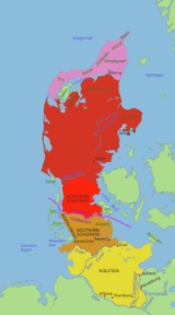
The historic region of Jutland
Jutland
Jutland , historically also called Cimbria, is the name of the peninsula that juts out in Northern Europe toward the rest of Scandinavia, forming the mainland part of Denmark. It has the North Sea to its west, Kattegat and Skagerrak to its north, the Baltic Sea to its east, and the Danish–German...
, the area that was covered by Codex Holmiensis
Codex Holmiensis
Codex Holmiensis is the manuscript of the Danish Code of Jutland, a civil code enacted under Valdemar II of Denmark. The code covered Funen and Jutland down to the Eider River....
(Jyske Lov) covered the Jutland Peninsula area north of Eider River and included Funen
Funen
Funen , with a size of 2,984 km² , is the third-largest island of Denmark following Zealand and Vendsyssel-Thy, and the 163rd largest island of the world. Funen is located in the central part of the country and has a population of 454,358 inhabitants . The main city is Odense, connected to the...
, the North Jutlandic Island and other smaller islands.