

Southern California freeways
Encyclopedia
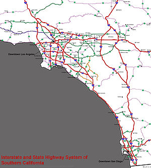
The Southern California freeways are a network of interconnected freeways in the Megaregion
of Southern California
with a population of 22 million. A comprehensive freeway plan was produced in 1947 and with construction beginning in the 1950s. The plan hit opposition and funding limitations in the 1970s and by 2004 some 61% of planned network had been completed.
's tight control over the region's commerce in the late 19th and early 20th centuries. During his successful campaign for governor in 1910, anti-Southern Pacific candidate Hiram Johnson
traveled the state by car (no small feat at that time). In the minds of Southlanders, this associated the automobile with clean, progressive government, in stark contrast to the railroads' control over the corrupt governments of the Midwest and Northeast. While the Southern Pacific-owned Pacific Electric Railway
's famous "Red Car" streetcar lines were the axes of urbanization in Los Angeles during its period of spectacular growth in the 1910s and 1920s, they were unprofitable and increasingly unattractive compared to automobiles. As cars became cheaper and began to fill the region's roads in the 1920s, the Pacific Electric both lost ridership and slowed to a crawl; traffic congestion soon threatened to choke off the region's development altogether. At the same time, a number of influential urban planners
were advocating the construction of a network of what one widely-read book dubbed "Magic Motorways", as the backbone of suburb
an development. These "greenbelt
" advocates called for decentralized, automobile-oriented development as a means of remedying both urban overcrowding and declining rates of home ownership.
Traffic congestion was of such great concern by the late 1930s in the Los Angeles metropolitan area
that the influential Automobile Club of Southern California
engineered an elaborate plan to create an elevated freeway-type "Motorway System," a key aspect of which was the dismantling of the streetcar lines, to be replaced with buses that could run on both local streets and on the new express roads. In the late 1930s when the freeway system was originally planned locally by Los Angeles city planners, they had intended that there were to have been light rail
tracks installed in the center margin of each freeway (these would presumably have carried Pacific Electric Railway
red cars), but this plan was never implemented.
, transportation bottlenecks on southern California roads and railways convinced many that if southern California were to accommodate a large population, it needed a completely new transportation system. The city of Los Angeles favored an upgraded rail transit system focused on its central city. However, the success of the Arroyo Seco Parkway, built between Los Angeles and Pasadena
in 1940, convinced many that a freeway system could solve the region's transportation problems. Leaders of surrounding cities, such as Whittier
, South Gate
, Long Beach
, and Pasadena, accordingly called for a web of freeways to connect the whole region, rather than funneling their residents out of their own downtowns and into that of Los Angeles. Pro-freeway sentiments prevailed, and by 1947 a new comprehensive freeway plan for Los Angeles (based largely on the original locally-planned 1930s system, but without the light rail tracks in the median strips of the freeways) had been drawn up by the California Department of Public Works (now "Caltrans"). San Diego soon followed suit, and by the early 1950s construction had begun on much of the region's freeway system.
, there was significant political opposition and the 1973 oil crisis
raised fuel prices dramatically. Growing interest in mass transit resulted in reduced funds being available for freeway construction. The California tax revolt
of the time also reduced the resources available for infrastructure development and Proposition 13, which was enacted in 1978 also reduced funds available for highway construction. The 1982 Surface Transportation Assistance Act
mandated that a some 11% of the Highway Trust Fund should be used for mass transit
schemes. The Century Freeway, which opened in 1993 following widespread community opposition, is likely to be the last freeway built using traditional funding.
Overall, only 61% of the freeway miles proposed in the 1954 master plan were built (as of 2004) with a number of key freeways left incomplete or un-built; the Long Beach and Glendale freeways were not completed and the Laurel Canyon and Beverly Hills freeways were never started. Other routes which presented expensive engineering challenges (e.g. the Angeles Crest and the Decker Freeways) were also dropped. The result was a system with gaps and bottlenecks with implications for the entire network.
By contrast, San Diego County is nearing completion of its originally planned freeway system and is using regional sales tax money support various extensions, and building new toll roads like State Route 125 to fill in the remaining gaps. The only major freeway not built was State Route 252 through Barrio Logan. Since the 1980s nearby Orange County
embarked on a program of tollway construction using local funds, and began to apply local financing to freeway construction as well after the turn of the 21st century.
in the early 1990s caused by the collapse of the defense industry at the end of the Cold War
, southern California began to grow again in the latter part of the decade. As in many other cities with rapidly growing populations, the region's infrastructure has had difficulty in keeping up. Traffic congestion in Los Angeles is the worst in the nation, and has been the worst since at least the early 1980s. However, even in the face of the state budget crisis of the early 2000s, plans have been drawn up to radically expand the region's transportation network to accommodate population growth that has already swelled the region's population to 17 million (as of the U.S. Census of 2000) and may see it grow to 25 or even 30 million in the coming decades. Environmentalist
sentiments, high fuel prices, and the dearth of available land may result in future development taking a pattern along the mass transit-oriented lines of the "smart growth
" school's recommendations.
Beginning originally in the 1970s, a variety of factors, including environmental concerns, an increasing population and the price of gasoline led to calls for mass transit other than buses. In 1976 the State of California formed the Los Angeles County Transportation Commission to coordinate the Southern California Rapid Transit District
's efforts with those of various municipal transit systems in the area and to take over planning of countywide transportation systems. The SCRTD continued planning of the Metrorail Subway (the Red Line
), while the LACTC developed plans for the light rail system. After decades, the wheels of government began to move forward, and construction began on the Los Angeles County Metro Rail
system in 1985. In 1988, the two agencies formed a third entity under which all rail construction would be consolidated. In 1993, the SCRTD and the LACTC were finally merged into the Los Angeles County Metropolitan Transportation Authority
which constructed subway
lines and which today continues to construct new light rail
lines.
[freeway number] ". In addition, sections of the southern California freeway system are often referred to by names rather than by the official numbers. For example, the names Santa Monica and San Bernardino are used for segments of Interstate 10 even though overhead freeway signs installed at interchanges since the 1990s don't display these names, using instead the highway number, direction, and control city
. A freeway 'name' may refer to portions of two or more differently numbered routes; for example, the Ventura Freeway
consists of portions of U.S. Route 101 and State Route 134.
The Southern California area has fewer lane-miles per capita than most larger metropolitan areas in the United States, ranking 31st of the top 39. As of 1999, Greater Los Angeles had 0.419 lane-miles per 1,000 people, only slightly more than Greater New York City
and fewer than Greater Boston
, the Washington Metropolitan Area
and the San Francisco Bay Area
. (American metros average .613 lane-miles per thousand) San Diego ranked 17th in the same study, with 0.659 lane-miles per thousand, and the Inland Empire
ranked 21st, with 0.626.
s are not maintained by the state:
Megaregions of the United States
A Megaregion, also known as a Megalopolis or Megapolitan Area, refers to a clustered network of American cities whose population ranges or is projected to range from about 7 to 63 million by the year 2025. America 2050, an organization sponsored by the Rockefeller and Ford Foundations, lists 11...
of Southern California
Southern California
Southern California is a megaregion, or megapolitan area, in the southern area of the U.S. state of California. Large urban areas include Greater Los Angeles and Greater San Diego. The urban area stretches along the coast from Ventura through the Southland and Inland Empire to San Diego...
with a population of 22 million. A comprehensive freeway plan was produced in 1947 and with construction beginning in the 1950s. The plan hit opposition and funding limitations in the 1970s and by 2004 some 61% of planned network had been completed.
Origins
Southern California's romance with the automobile owes in large part to resentment of the Southern Pacific RailroadSouthern Pacific Railroad
The Southern Pacific Transportation Company , earlier Southern Pacific Railroad and Southern Pacific Company, and usually simply called the Southern Pacific or Espee, was an American railroad....
's tight control over the region's commerce in the late 19th and early 20th centuries. During his successful campaign for governor in 1910, anti-Southern Pacific candidate Hiram Johnson
Hiram Johnson
Hiram Warren Johnson was a leading American progressive and later isolationist politician from California; he served as the 23rd Governor from 1911 to 1917, and as a United States Senator from 1917 to 1945.-Early life:...
traveled the state by car (no small feat at that time). In the minds of Southlanders, this associated the automobile with clean, progressive government, in stark contrast to the railroads' control over the corrupt governments of the Midwest and Northeast. While the Southern Pacific-owned Pacific Electric Railway
Pacific Electric Railway
The Pacific Electric Railway , also known as the Red Car system, was a mass transit system in Southern California using streetcars, light rail, and buses...
's famous "Red Car" streetcar lines were the axes of urbanization in Los Angeles during its period of spectacular growth in the 1910s and 1920s, they were unprofitable and increasingly unattractive compared to automobiles. As cars became cheaper and began to fill the region's roads in the 1920s, the Pacific Electric both lost ridership and slowed to a crawl; traffic congestion soon threatened to choke off the region's development altogether. At the same time, a number of influential urban planners
Urban planning
Urban planning incorporates areas such as economics, design, ecology, sociology, geography, law, political science, and statistics to guide and ensure the orderly development of settlements and communities....
were advocating the construction of a network of what one widely-read book dubbed "Magic Motorways", as the backbone of suburb
Suburb
The word suburb mostly refers to a residential area, either existing as part of a city or as a separate residential community within commuting distance of a city . Some suburbs have a degree of administrative autonomy, and most have lower population density than inner city neighborhoods...
an development. These "greenbelt
Green belt
A green belt or greenbelt is a policy and land use designation used in land use planning to retain areas of largely undeveloped, wild, or agricultural land surrounding or neighbouring urban areas. Similar concepts are greenways or green wedges which have a linear character and may run through an...
" advocates called for decentralized, automobile-oriented development as a means of remedying both urban overcrowding and declining rates of home ownership.
Traffic congestion was of such great concern by the late 1930s in the Los Angeles metropolitan area
Los Angeles Metropolitan Area
The Los Angeles metropolitan area, also known as Metropolitan Los Angeles or the Southland, is the 13th largest metropolitan area in the world and the second-largest metropolitan area in the United States....
that the influential Automobile Club of Southern California
Automobile Club of Southern California
The Automobile Club of Southern California is the Southern California affiliate of the American Automobile Association federation of motor clubs...
engineered an elaborate plan to create an elevated freeway-type "Motorway System," a key aspect of which was the dismantling of the streetcar lines, to be replaced with buses that could run on both local streets and on the new express roads. In the late 1930s when the freeway system was originally planned locally by Los Angeles city planners, they had intended that there were to have been light rail
Light rail
Light rail or light rail transit is a form of urban rail public transportation that generally has a lower capacity and lower speed than heavy rail and metro systems, but higher capacity and higher speed than traditional street-running tram systems...
tracks installed in the center margin of each freeway (these would presumably have carried Pacific Electric Railway
Pacific Electric Railway
The Pacific Electric Railway , also known as the Red Car system, was a mass transit system in Southern California using streetcars, light rail, and buses...
red cars), but this plan was never implemented.
Planning and construction
During World War IIWorld War II
World War II, or the Second World War , was a global conflict lasting from 1939 to 1945, involving most of the world's nations—including all of the great powers—eventually forming two opposing military alliances: the Allies and the Axis...
, transportation bottlenecks on southern California roads and railways convinced many that if southern California were to accommodate a large population, it needed a completely new transportation system. The city of Los Angeles favored an upgraded rail transit system focused on its central city. However, the success of the Arroyo Seco Parkway, built between Los Angeles and Pasadena
Pasadena, California
Pasadena is a city in Los Angeles County, California, United States. Although famous for hosting the annual Rose Bowl football game and Tournament of Roses Parade, Pasadena is the home to many scientific and cultural institutions, including the California Institute of Technology , the Jet...
in 1940, convinced many that a freeway system could solve the region's transportation problems. Leaders of surrounding cities, such as Whittier
Whittier, California
Whittier is a city in Los Angeles County, California about southeast of Los Angeles. The city had a population of 85,331 at the 2010 census, up from 83,680 as of the 2000 census, and encompasses 14.7 square miles . Like nearby Montebello, the city constitutes part of the Gateway Cities...
, South Gate
South Gate, California
South Gate is a city in Los Angeles County, California, United States. The sixteenth largest city in Los Angeles County, it encompasses . South Gate is located just southeast of downtown Los Angeles It is part of the Gateway Cities region of southeastern Los Angeles County...
, Long Beach
Long Beach, California
Long Beach is a city situated in Los Angeles County in Southern California, on the Pacific coast of the United States. The city is the 36th-largest city in the nation and the seventh-largest in California. As of 2010, its population was 462,257...
, and Pasadena, accordingly called for a web of freeways to connect the whole region, rather than funneling their residents out of their own downtowns and into that of Los Angeles. Pro-freeway sentiments prevailed, and by 1947 a new comprehensive freeway plan for Los Angeles (based largely on the original locally-planned 1930s system, but without the light rail tracks in the median strips of the freeways) had been drawn up by the California Department of Public Works (now "Caltrans"). San Diego soon followed suit, and by the early 1950s construction had begun on much of the region's freeway system.
Discontent
By the 1970s many cities in the USA, including Los Angeles were experiencing widespread Freeway and expressway revoltsFreeway and expressway revolts
Many freeway revolts took place in developed countries during the 1960s and 1970s, in response to plans for the construction of new freeways, a significant number of which were abandoned or significantly scaled back due to widespread public opposition; especially of those whose neighborhoods would...
, there was significant political opposition and the 1973 oil crisis
1973 oil crisis
The 1973 oil crisis started in October 1973, when the members of Organization of Arab Petroleum Exporting Countries or the OAPEC proclaimed an oil embargo. This was "in response to the U.S. decision to re-supply the Israeli military" during the Yom Kippur war. It lasted until March 1974. With the...
raised fuel prices dramatically. Growing interest in mass transit resulted in reduced funds being available for freeway construction. The California tax revolt
Tax revolt
A tax revolt is a political struggle to repeal, limit, or roll back a tax.-1930s, The Great Depression:In the United States, the term "tax revolt" is sometimes used to refer to a series of anti-tax state initiative campaigns. The first significant wave of these campaigns was during the 1930s. The...
of the time also reduced the resources available for infrastructure development and Proposition 13, which was enacted in 1978 also reduced funds available for highway construction. The 1982 Surface Transportation Assistance Act
Surface Transportation Assistance Act
The Surface Transportation Assistance Act of 1982 was a comprehensive transportation funding and policy act of the United States Federal Government, . The legislation was championed by the Reagan administration to address concerns about the surface transportation infrastructure...
mandated that a some 11% of the Highway Trust Fund should be used for mass transit
Public transport
Public transport is a shared passenger transportation service which is available for use by the general public, as distinct from modes such as taxicab, car pooling or hired buses which are not shared by strangers without private arrangement.Public transport modes include buses, trolleybuses, trams...
schemes. The Century Freeway, which opened in 1993 following widespread community opposition, is likely to be the last freeway built using traditional funding.
Overall, only 61% of the freeway miles proposed in the 1954 master plan were built (as of 2004) with a number of key freeways left incomplete or un-built; the Long Beach and Glendale freeways were not completed and the Laurel Canyon and Beverly Hills freeways were never started. Other routes which presented expensive engineering challenges (e.g. the Angeles Crest and the Decker Freeways) were also dropped. The result was a system with gaps and bottlenecks with implications for the entire network.
By contrast, San Diego County is nearing completion of its originally planned freeway system and is using regional sales tax money support various extensions, and building new toll roads like State Route 125 to fill in the remaining gaps. The only major freeway not built was State Route 252 through Barrio Logan. Since the 1980s nearby Orange County
Orange County, California
Orange County is a county in the U.S. state of California. Its county seat is Santa Ana. As of the 2010 census, its population was 3,010,232, up from 2,846,293 at the 2000 census, making it the third most populous county in California, behind Los Angeles County and San Diego County...
embarked on a program of tollway construction using local funds, and began to apply local financing to freeway construction as well after the turn of the 21st century.
Revival of interest in mass transit
After a deep recessionRecession
In economics, a recession is a business cycle contraction, a general slowdown in economic activity. During recessions, many macroeconomic indicators vary in a similar way...
in the early 1990s caused by the collapse of the defense industry at the end of the Cold War
Cold War
The Cold War was the continuing state from roughly 1946 to 1991 of political conflict, military tension, proxy wars, and economic competition between the Communist World—primarily the Soviet Union and its satellite states and allies—and the powers of the Western world, primarily the United States...
, southern California began to grow again in the latter part of the decade. As in many other cities with rapidly growing populations, the region's infrastructure has had difficulty in keeping up. Traffic congestion in Los Angeles is the worst in the nation, and has been the worst since at least the early 1980s. However, even in the face of the state budget crisis of the early 2000s, plans have been drawn up to radically expand the region's transportation network to accommodate population growth that has already swelled the region's population to 17 million (as of the U.S. Census of 2000) and may see it grow to 25 or even 30 million in the coming decades. Environmentalist
Environmentalism
Environmentalism is a broad philosophy, ideology and social movement regarding concerns for environmental conservation and improvement of the health of the environment, particularly as the measure for this health seeks to incorporate the concerns of non-human elements...
sentiments, high fuel prices, and the dearth of available land may result in future development taking a pattern along the mass transit-oriented lines of the "smart growth
Smart growth
Smart growth is an urban planning and transportation theory that concentrates growth in compact walkable urban centers to avoid sprawl and advocates compact, transit-oriented, walkable, bicycle-friendly land use, including neighborhood schools, complete streets, and mixed-use development with a...
" school's recommendations.
Beginning originally in the 1970s, a variety of factors, including environmental concerns, an increasing population and the price of gasoline led to calls for mass transit other than buses. In 1976 the State of California formed the Los Angeles County Transportation Commission to coordinate the Southern California Rapid Transit District
Southern California Rapid Transit District
The Southern California Rapid Transit District , was the successor to the original Metropolitan Transit Authority after it virtually went bankrupt...
's efforts with those of various municipal transit systems in the area and to take over planning of countywide transportation systems. The SCRTD continued planning of the Metrorail Subway (the Red Line
LACMTA Red Line
The Red Line is a subway line running between Downtown Los Angeles via the districts of Hollywood and Mid-Wilshire to North Hollywood within Los Angeles where it connects with the Metroliner Orange line service for stations to the Warner Center in Woodland Hills.The red line, which is one of five...
), while the LACTC developed plans for the light rail system. After decades, the wheels of government began to move forward, and construction began on the Los Angeles County Metro Rail
Los Angeles County Metro Rail
Metro Rail is the rapid transit rail system consisting of five separate lines serving 70 stations in the Los Angeles County, California area. The new Expo line is due to enter service in early 2012. It connects with the Metro liner bus rapid transit system and also with the Metrolink commuter...
system in 1985. In 1988, the two agencies formed a third entity under which all rail construction would be consolidated. In 1993, the SCRTD and the LACTC were finally merged into the Los Angeles County Metropolitan Transportation Authority
Los Angeles County Metropolitan Transportation Authority
The Los Angeles County Metropolitan Transportation Authority is the California state-chartered regional transportation planning agency and public transportation operating agency for the County of Los Angeles formed in 1993 out of a merger of the Southern California Rapid Transit District and the...
which constructed subway
Los Angeles County Metro Rail
Metro Rail is the rapid transit rail system consisting of five separate lines serving 70 stations in the Los Angeles County, California area. The new Expo line is due to enter service in early 2012. It connects with the Metro liner bus rapid transit system and also with the Metrolink commuter...
lines and which today continues to construct new light rail
Light rail
Light rail or light rail transit is a form of urban rail public transportation that generally has a lower capacity and lower speed than heavy rail and metro systems, but higher capacity and higher speed than traditional street-running tram systems...
lines.
Proposed/future freeways
Caltrans or local transportation agencies have identified the following priority freeway projects:- A new freeway across the Santa Ana MountainsSanta Ana MountainsThe Santa Ana Mountains are a short peninsular mountain range along the coast of Southern California in the United States. They extend for approximately 36 mi southeast of the Los Angeles Basin largely along the border between Orange and Riverside counties.- Geography :The range starts in the...
to relieve congestion on State Route 91, Riverside FreewayRiverside FreewayThe Riverside Freeway is a named freeway in Orange, Riverside, and San Bernardino Counties in the U.S. state of California. It refers to the following two segments:...
, and provide a route between the Inland EmpireInland Empire (California)The Inland Empire is a region in Southern California. The region sits directly east of the Los Angeles metropolitan area. The Inland Empire most commonly is used in reference to the U.S. Census Bureau's federally-defined Riverside-San Bernardino-Ontario metropolitan area, which covers more than...
and southern Orange County. - A new freeway, the Mid County ParkwayMid County ParkwayThe Mid County Parkway is a proposed highway in Riverside County, California, United States which would link San Jacinto in the east and Perris in the west in response to high levels on congestion on existing routes. The corridor was identified by the Riverside County Integrated Project....
from Lake ElsinoreLake Elsinore, CaliforniaFor the lake see Lake Elsinore.Lake Elsinore or LE is a city in western Riverside County, California. The population was 51,821 at the 2010 census...
to San JacintoSan Jacinto, CaliforniaSan Jacinto is a city in Riverside County, California, U.S.A. It was named after Saint Hyacinth and is located at the north end of the San Jacinto Valley, with Hemet to its south. The mountains associated with the valley are the San Jacinto Mountains. The population was 44,199 at the 2010...
. - Extension to Interstate 710, Long Beach Freeway, to its originally planned terminus at Interstate 210Interstate 210 (California)Interstate 210 and State Route 210 together form a contiguous highway, called the Foothill Freeway, in the Greater Los Angeles area of the U.S. state of California. The western portion of the route is an auxiliary Interstate Highway, while the eastern portion is a state highway...
, Foothill Freeway, in PasadenaPasadena, CaliforniaPasadena is a city in Los Angeles County, California, United States. Although famous for hosting the annual Rose Bowl football game and Tournament of Roses Parade, Pasadena is the home to many scientific and cultural institutions, including the California Institute of Technology , the Jet...
, via a tunnelTunnelA tunnel is an underground passageway, completely enclosed except for openings for egress, commonly at each end.A tunnel may be for foot or vehicular road traffic, for rail traffic, or for a canal. Some tunnels are aqueducts to supply water for consumption or for hydroelectric stations or are sewers...
underneath the city of South PasadenaSouth Pasadena, CaliforniaSouth Pasadena is a city in Los Angeles County, California, United States. As of the 2010 census, it had a population of 25,619, up from 24,292 at the 2000 census. It is located in in the West San Gabriel Valley...
. - An extension to the State Route 241California State Route 241State Route 241 is a state highway in the U.S. state of California. For its entire run, Route 241 is a toll road. Its northern half is part of the Eastern Toll Road while its southern half is part of the Foothill Toll Road....
toll roadToll roadA toll road is a privately or publicly built road for which a driver pays a toll for use. Structures for which tolls are charged include toll bridges and toll tunnels. Non-toll roads are financed using other sources of revenue, most typically fuel tax or general tax funds...
to meet Interstate 5Interstate 5 in CaliforniaInterstate 5 is a major north–south route of the Interstate Highway System in the U.S. state of California. It begins at the Mexico – United States border at the San Ysidro crossing, goes north across the length of California and crosses into Oregon south of the Medford-Ashland metropolitan...
in San ClementeSan Clemente, CaliforniaSan Clemente is a city in Orange County, California. The population was 63,522 at the 2010 census. Located on the California Coast, midway between Los Angeles and San Diego at the southern tip of the county, it is known for its ocean, hill, and mountain views, a pleasant climate and its Spanish...
. - An extension to State Route 905/future Interstate 905 to reach the Otay Mesa border crossing, with a junction at State Route 125 and future State Route 11.
- Upgrade to State Route 71, Chino Valley Freeway, north of State Route 60, Pomona Freeway, to Interstate 10Interstate 10 in CaliforniaInterstate 10 , the major east–west Interstate Highway in the Southern United States, runs in the U.S. state of California east from Santa Monica, on the Pacific Ocean, through Los Angeles and San Bernardino to the border with Arizona...
, San Bernardino FreewaySan Bernardino FreewayThe San Bernardino Freeway, formerly known as the Ramona Freeway is a freeway in Los Angeles and Orange Counties in the southern part of the U.S. state of California. It refers to the following two segments:...
, in PomonaPomona, California-2010:The 2010 United States Census reported that Pomona had a population of 149,058, a slight decline from the 2000 census population. The population density was 6,491.2 people per square mile...
. - Upgrade to State Route 55, Costa Mesa Freeway, from south of its current freeway terminus at 19th Street in Costa MesaCosta Mesa, CaliforniaCosta Mesa is a city in Orange County, California. The population was 109,960 at the 2010 census. Since its incorporation in 1953, the city has grown from a semi-rural farming community of 16,840 to a primarily suburban and "edge" city with an economy based on retail, commerce, and light...
to State Route 1, Pacific Coast Highway, in Newport BeachNewport Beach, CaliforniaNewport Beach, incorporated in 1906, is a city in Orange County, California, south of downtown Santa Ana. The population was 85,186 at the 2010 census.The city's median family income and property values consistently place high in national rankings...
, potentially via a tunnel. - Construction of the High Desert Corridor, a freeway and expresswayExpresswayExpressway may refer to:*Controlled-access highway, the highest-grade type of highway with access ramps, lane dividers, etc., for high-speed traffic*Limited-access road, a lower grade of highway or arterial road...
between State Route 14, Antelope Valley Freeway, in PalmdalePalmdale, CaliforniaPalmdale is a city located in the center of northern Los Angeles County, California, United States.Palmdale was the first community within the Antelope Valley to incorporate as a city on August 24, 1962; 47 years later, voters approved creating a charter city in November, 2009. Palmdale is...
and Interstate 15Interstate 15 in CaliforniaIn the U.S. state of California, Interstate 15 is a major north–south route through the San Bernardino, Riverside, and San Diego Counties, and it has a length of in the state. It is a major thoroughfare for traffic between Southern California and Las Vegas, Nevada, as well as points beyond...
, Mojave Freeway, near VictorvilleVictorville, CaliforniaVictorville is a city located in the Victor Valley of southwestern San Bernardino County, California. According to the U.S. Census Bureau's 2010 census, the city had a population of 115,903, up from 64,030 at the 2000 census.-Geography and climate:... - Addition of high occupancy vehicle and high occupancy toll lanes to freeway segments currently lacking them.
- Construction of lower-inclined alternate alignments on steep segments of freeway, to enable trucks to climb mountain passes more easily and speed up the flow of automobile traffic.
Freeway names
Southern California residents idiomatically refer to freeways with the definite article, as "theControl city
A control city is a city or locality posted on a traffic sign indicating forward destinations on a certain route. These destinations aid motorists using the highway system to reach destinations along the various routes...
. A freeway 'name' may refer to portions of two or more differently numbered routes; for example, the Ventura Freeway
Ventura Freeway
The Ventura Freeway is a freeway in southern California running from Ventura to Pasadena. It is the principal east-west route through Ventura County and in the southern San Fernando Valley in Los Angeles County. From Ventura to its intersection with the Hollywood Freeway in the southeastern San...
consists of portions of U.S. Route 101 and State Route 134.
Named interchanges
- Four LevelFour Level InterchangeThe Four Level Interchange was the first stack interchange in the world. Completed in 1949 and fully opened in 1953 at the northern edge of downtown Los Angeles, California, USA, it connects U.S...
(Bill KeeneBill KeeneBill Keene was a television and radio personality who became famous in the Los Angeles, California market as a traffic and weather announcer...
Memorial): US-101/SR-110 - East Los AngelesEast Los Angeles InterchangeThe East Los Angeles Interchange complex is the busiest freeway interchange in the world, with its southern portion handling over 550,000 vehicles per day . The northern portion, called the San Bernardino Split, is often considered a separate interchange. The interchange was named the Eugene A....
: I-5/US-101/I-10/SR-60California State Route 60State Route 60 is a state highway in the U.S. state of California. It runs from Interstate 10 near the Los Angeles River in Los Angeles east to I-10 in Riverside County, with overlaps at State Route 57 and Interstate 215.-Route description:... - Hollywood SplitHollywood SplitThe Hollywood Split is a freeway interchange in the San Fernando Valley area of Los Angeles, California...
(Bruce T. Hinman Memorial): US-101/SR-134 - Judge Harry PregersonJudge Harry Pregerson InterchangeThe Judge Harry Pregerson Interchange is a stack interchange near the Athens and Watts communities of Los Angeles, California. It is the interchange of the following routes:...
: I-105Interstate 105 (California)Interstate 105 is an Interstate Highway in southern Los Angeles County, California that runs east–west from near the Los Angeles International Airport to Norwalk...
/I-110Interstate 110 (California)Route 110, consisting of two segments of State Route 110 joined by Interstate 110 , is a state highway in the Los Angeles area of the U.S. state of California, mostly built to freeway standards... - El Toro YEl Toro YThe El Toro "Y" is a freeway interchange in southern Orange County, California where the Santa Ana Freeway, Interstate 5, and the San Diego Freeway, Interstate 405 merge...
: Southern junction of I-5/I-405Interstate 405 (California)Interstate 405 is a major north–south Interstate Highway in Southern California. It is a bypass of Interstate 5, running along the western areas of the Greater Los Angeles Area from Irvine in the south to near San Fernando in the north... - KelloggKellogg InterchangeThe Kellogg Interchange complex is a freeway interchange in Southern California. The interchange is located at the boundary between the cities of San Dimas and Pomona about east of downtown Los Angeles. It is named for the nearby W. K. Kellogg Ranch, now home to Cal Poly Pomona.-Description:The...
: I-10/SR-57California State Route 57State Route 57 , also known as the Orange Freeway, is a north–south state highway in the Greater Los Angeles Area of the U.S. state of California. It connects the interchange of Interstate 5 and State Route 22 near downtown Orange, locally known as the Orange Crush, with the Glendora Curve...
/SR-71California State Route 71State Route 71 is the Chino Valley Freeway, formerly the Corona Expressway and before then the Temescal Freeway, a freeway/highway of about 15 miles in length located entirely within Southern California, United States... - Orange CrushOrange Crush interchangeThe Orange Crush Interchange is a freeway interchange in the city of Orange, California, near the confluence of the cities of Orange, Santa Ana, Anaheim, and Garden Grove. The Disneyland Resort, The Block at Orange, St...
: I-5/SR-22California State Route 22State Route 22 in the U.S. state of California is an east–west highway in southern Los Angeles County and northern Orange County. It runs between Long Beach and Orange by way of Garden Grove. The westernmost part of it is a surface street, Long Beach's 7th Street. From Long Beach to its...
/SR-57California State Route 57State Route 57 , also known as the Orange Freeway, is a north–south state highway in the Greater Los Angeles Area of the U.S. state of California. It connects the interchange of Interstate 5 and State Route 22 near downtown Orange, locally known as the Orange Crush, with the Glendora Curve... - Newhall PassNewhall Pass interchangeThe Newhall Pass Interchange is a highway interchange at Newhall Pass, north of Sylmar in Southern California, United States. It connects Interstate 5 with State Route 14 , and includes truck bypass roadways...
(Clarence Wayne Dean Memorial): I-5/SR-14California State Route 14State Route 14 is a north–south state highway in the U.S. state of California, largely in the Mojave Desert. The southern portion of the highway is signed as the Antelope Valley Freeway. The route connects Interstate 5, or Golden State Freeway, near Santa Clarita and with U.S. Route 395 near... - Glendora Curve: I-210Interstate 210 (California)Interstate 210 and State Route 210 together form a contiguous highway, called the Foothill Freeway, in the Greater Los Angeles area of the U.S. state of California. The western portion of the route is an auxiliary Interstate Highway, while the eastern portion is a state highway...
/SR-57California State Route 57State Route 57 , also known as the Orange Freeway, is a north–south state highway in the Greater Los Angeles Area of the U.S. state of California. It connects the interchange of Interstate 5 and State Route 22 near downtown Orange, locally known as the Orange Crush, with the Glendora Curve... - Jack Schrade (Mission Valley Viaduct): I-8/I-805
Other named features
- South Bay Curve: where Interstate 405Interstate 405 (California)Interstate 405 is a major north–south Interstate Highway in Southern California. It is a bypass of Interstate 5, running along the western areas of the Greater Los Angeles Area from Irvine in the south to near San Fernando in the north...
bends from north–south to east–west in TorranceTorrance, CaliforniaTorrance is a city incorporated in 1921 and located in the South Bay region of Los Angeles County, California, United States. Torrance has of shore-front beaches on the Pacific Ocean, quieter and less well-known by tourists than others on the Santa Monica Bay, such as those of neighboring... - Sepulveda PassSepulveda PassSepulveda Pass is a mountain pass through the Santa Monica Mountains in Los Angeles.It connects the Los Angeles Basin to the San Fernando Valley via the San Diego Freeway and Sepulveda Boulevard and experiences heavy traffic on a regular basis, commonly experiencing major traffic slowdowns and...
: Interstate 405Interstate 405 (California)Interstate 405 is a major north–south Interstate Highway in Southern California. It is a bypass of Interstate 5, running along the western areas of the Greater Los Angeles Area from Irvine in the south to near San Fernando in the north...
just south of U.S. Route 101 near the J. Paul Getty MuseumJ. Paul Getty MuseumThe J. Paul Getty Museum, a program of the J. Paul Getty Trust, is an art museum. It has two locations, one at the Getty Center in Los Angeles, California, and one at the Getty Villa in Pacific Palisades, Los Angeles, California...
. - Cahuenga PassCahuenga PassThe Cahuenga Pass is a mountain pass through the eastern end of the Santa Monica Mountains in the Hollywood district of the City of Los Angeles, California....
: the Hollywood FreewayHollywood FreewayThe Hollywood Freeway is one of the principal freeways of Los Angeles, California and one of the busiest in the United States. It is the principal route over the Cahuenga Pass, the primary shortcut between the Los Angeles Basin and the San Fernando Valley...
just south of the interchange with the Ventura FreewayVentura FreewayThe Ventura Freeway is a freeway in southern California running from Ventura to Pasadena. It is the principal east-west route through Ventura County and in the southern San Fernando Valley in Los Angeles County. From Ventura to its intersection with the Hollywood Freeway in the southeastern San... - Figueroa Street TunnelsFigueroa Street TunnelsThe Figueroa Street Tunnels are a set of four four-lane tunnels that carry northbound traffic on State Route 110 through Elysian Park in Los Angeles, California, United States. From south to north, the four tunnels measure 755, 461, 130 and 405 feet in length, 46.5 feet in width, and...
: the northbound lanes of the Pasadena FreewayPasadena FreewayThe Arroyo Seco Parkway, formerly known as the Pasadena Freeway, is the first freeway in California and the western United States. It connects Los Angeles with Pasadena alongside the Arroyo Seco. It is notable not only for being the first, mostly opened in 1940, but for representing the...
between the Four Level InterchangeFour Level InterchangeThe Four Level Interchange was the first stack interchange in the world. Completed in 1949 and fully opened in 1953 at the northern edge of downtown Los Angeles, California, USA, it connects U.S...
and the interchange with the Golden State Freeway - Glendora Curve: the transition of the northbound 57 Orange Freeway to the westbound 210 Foothill Freeway; or the eastbound 210 transition to the southbound 57. Formerly part of Interstate 210 before the completion of the newer section of the Foothill Freeway in 2003.
Comparisons and 'firsts'
- First freeway in California (Arroyo Seco Parkway linking PasadenaPasadena, CaliforniaPasadena is a city in Los Angeles County, California, United States. Although famous for hosting the annual Rose Bowl football game and Tournament of Roses Parade, Pasadena is the home to many scientific and cultural institutions, including the California Institute of Technology , the Jet...
and Los AngelesLos ÁngelesLos Ángeles is the capital of the province of Biobío, in the commune of the same name, in Region VIII , in the center-south of Chile. It is located between the Laja and Biobío rivers. The population is 123,445 inhabitants...
) - First stack interchangeStack interchangeA stack interchange is a free-flowing grade separated junction between two roads.In countries where one drives on the right, left turns are handled by semi-directional flyover/under ramps...
(Four Level InterchangeFour Level InterchangeThe Four Level Interchange was the first stack interchange in the world. Completed in 1949 and fully opened in 1953 at the northern edge of downtown Los Angeles, California, USA, it connects U.S...
in downtown Los Angeles) - First grade-separated HOV lanes
- First fully automated tollway system (91 Express Lanes in northern Orange County)
The Southern California area has fewer lane-miles per capita than most larger metropolitan areas in the United States, ranking 31st of the top 39. As of 1999, Greater Los Angeles had 0.419 lane-miles per 1,000 people, only slightly more than Greater New York City
New York metropolitan area
The New York metropolitan area, also known as Greater New York, or the Tri-State area, is the region that composes of New York City and the surrounding region...
and fewer than Greater Boston
Greater Boston
Greater Boston is the area of the Commonwealth of Massachusetts surrounding the city of Boston. Due to ambiguity in usage, the size of the area referred to can be anywhere between that of the metropolitan statistical area of Boston and that of the city's combined statistical area which includes...
, the Washington Metropolitan Area
Washington Metropolitan Area
The Washington Metropolitan Area is the metropolitan area centered on Washington, D.C., the capital of the United States. The area includes all of the federal district and parts of the U.S...
and the San Francisco Bay Area
San Francisco Bay Area
The San Francisco Bay Area, commonly known as the Bay Area, is a populated region that surrounds the San Francisco and San Pablo estuaries in Northern California. The region encompasses metropolitan areas of San Francisco, Oakland, and San Jose, along with smaller urban and rural areas...
. (American metros average .613 lane-miles per thousand) San Diego ranked 17th in the same study, with 0.659 lane-miles per thousand, and the Inland Empire
Inland Empire (California)
The Inland Empire is a region in Southern California. The region sits directly east of the Los Angeles metropolitan area. The Inland Empire most commonly is used in reference to the U.S. Census Bureau's federally-defined Riverside-San Bernardino-Ontario metropolitan area, which covers more than...
ranked 21st, with 0.626.
Limited-access roads not maintained by the state
The following of Limited-access roadLimited-access road
A limited-access road known by various terms worldwide, including limited-access highway, dual-carriageway and expressway, is a highway or arterial road for high-speed traffic which has many or most characteristics of a controlled-access highway , including limited or no access to adjacent...
s are not maintained by the state:
- Colorado Street former routing of State Route 134 from Interstate 5 to San Fernando RoadSan Fernando RoadSan Fernando Road is a major street in the city and county of Los Angeles. It starts off in Castaic as The Old Road, passing through Santa Clarita and the Newhall Pass, whereupon its intersection with Sierra Highway near the junction of the Golden State and the Antelope Valley Freeways, it...
just west of GlendaleGlendale, CaliforniaGlendale is a city in Los Angeles County, California, United States. As of the 2010 Census, the city population is 191,719, down from 194,973 at the 2000 census. making it the third largest city in Los Angeles County and the 22nd largest city in the state of California... - Colorado Freeway former routing of State Route 134 from Colorado Blvd in Eagle RockEagle RockEagle Rock can refer to one of the following:Places in the United States*Eagle Rock, North Carolina, an unincorporated community in Wake County, North Carolina, west of Zebulon*Eagle Rock , a town in northern Botetourt County...
to the Ventura FreewayVentura FreewayThe Ventura Freeway is a freeway in southern California running from Ventura to Pasadena. It is the principal east-west route through Ventura County and in the southern San Fernando Valley in Los Angeles County. From Ventura to its intersection with the Hollywood Freeway in the southeastern San... - Oak Grove Drive in PasadenaPasadena, CaliforniaPasadena is a city in Los Angeles County, California, United States. Although famous for hosting the annual Rose Bowl football game and Tournament of Roses Parade, Pasadena is the home to many scientific and cultural institutions, including the California Institute of Technology , the Jet...
, former routing of the Foothill Freeway - Shoreline Drive in Long BeachLong Beach, CaliforniaLong Beach is a city situated in Los Angeles County in Southern California, on the Pacific coast of the United States. The city is the 36th-largest city in the nation and the seventh-largest in California. As of 2010, its population was 462,257...
- La Cienega BoulevardLa Cienega BoulevardLa Cienega Boulevard is a major, well-known north–south arterial road that runs between El Segundo Boulevard in El Segundo, California on the south and the Sunset Strip/Sunset Boulevard in West Hollywood....
in the Baldwin Hills, originally intended to be part of the discontinued Laurel Canyon Freeway
Major freeways leading into and out of Southern California
- Interstate 5 southbound to Baja CaliforniaBaja CaliforniaBaja California officially Estado Libre y Soberano de Baja California is one of the 31 states which, with the Federal District, comprise the 32 Federal Entities of Mexico. It is both the northernmost and westernmost state of Mexico. Before becoming a state in 1953, the area was known as the North...
, northbound to the Central Valley- John J. Montgomery Freeway from U.S.-Mexico border crossing at San YsidroSan Ysidro, San Diego, CaliforniaSan Ysidro is a community in the southern section of San Diego. It is located in the southernmost part of San Diego County, immediately north of the U.S.-Mexico border. It neighbors Otay Mesa West to the north, Otay Mesa to the east, and Nestor and the Tijuana River Valley to the west...
to Downtown San Diego - San Diego FreewayInterstate 5 in CaliforniaInterstate 5 is a major north–south route of the Interstate Highway System in the U.S. state of California. It begins at the Mexico – United States border at the San Ysidro crossing, goes north across the length of California and crosses into Oregon south of the Medford-Ashland metropolitan...
from Downtown San Diego to the El Toro YEl Toro YThe El Toro "Y" is a freeway interchange in southern Orange County, California where the Santa Ana Freeway, Interstate 5, and the San Diego Freeway, Interstate 405 merge... - Santa Ana FreewaySanta Ana FreewayThe Santa Ana Freeway is one of the principal freeways in Southern California, connecting Los Angeles and its southeastern suburbs including the freeway's namesake, the city of Santa Ana. The freeway begins at the Four Level Interchange in downtown Los Angeles, signed as U.S. Route 101...
from the El Toro Y to the East L.A. Interchange - Golden State Freeway from the East L.A. Interchange to Wheeler RidgeWheeler Ridge, CaliforniaWheeler Ridge is an unincorporated community in Kern County, California. It is located south-southeast of Mettler, at an elevation of 955 feet .A post office operated at Wheeler Ridge from 1923 to 1972....
- John J. Montgomery Freeway from U.S.-Mexico border crossing at San Ysidro
- Interstate 8 west terminus in Ocean BeachOcean Beach- Places :Australia* Ocean Beach * Ocean Beach New Zealand* Ocean Beach, Hawke's Bay* Ocean Beach, OtagoUnited States* Ocean Beach, San Diego, California, also community* Ocean Beach, San Francisco, California...
in San Diego, eastbound to the ArizonaArizonaArizona ; is a state located in the southwestern region of the United States. It is also part of the western United States and the mountain west. The capital and largest city is Phoenix...
State Line- Ocean Beach Freeway from Ocean Beach in San Diego to Old Town San Diego
- Mission Valley Freeway, also known as the Alvarado Freeway, from Old Town San Diego to El CajonEl Cajon, California-History:El Cajon is located on the Rancho El Cajon Mexican land grant made in 1845 to María Antonia Estudillo, wife of Miguel Pedrorena. In 1876 Amaziah Lord Knox , a New Englander who had recently moved to California, established a hotel there to serve the growing number of people traveling...
- Kumeyaay Highway from Ocean Beach to the San DiegoSan Diego County, CaliforniaSan Diego County is a large county located in the southwestern corner of the US state of California. Hence, San Diego County is also located in the southwestern corner of the 48 contiguous United States. Its county seat and largest city is San Diego. Its population was about 2,813,835 in the 2000...
-Imperial CountyImperial County, CaliforniaImperial County is a county located in the Imperial Valley, in the far southeast of the U.S. state of California, bordering both Arizona and Mexico. It is part of the El Centro Metropolitan Area, which encompasses all of Imperial County. The population as of 2000 was 142,361. The county seat is the...
Line
- Interstate 10 west terminus in Santa MonicaSanta Monica, CaliforniaSanta Monica is a beachfront city in western Los Angeles County, California, US. Situated on Santa Monica Bay, it is surrounded on three sides by the city of Los Angeles — Pacific Palisades on the northwest, Brentwood on the north, West Los Angeles on the northeast, Mar Vista on the east, and...
, eastbound to the ArizonaArizonaArizona ; is a state located in the southwestern region of the United States. It is also part of the western United States and the mountain west. The capital and largest city is Phoenix...
State Line- Santa Monica Freeway from Santa MonicaSanta Monica, CaliforniaSanta Monica is a beachfront city in western Los Angeles County, California, US. Situated on Santa Monica Bay, it is surrounded on three sides by the city of Los Angeles — Pacific Palisades on the northwest, Brentwood on the north, West Los Angeles on the northeast, Mar Vista on the east, and...
to the East L.A. Interchange - San Bernardino FreewaySan Bernardino FreewayThe San Bernardino Freeway, formerly known as the Ramona Freeway is a freeway in Los Angeles and Orange Counties in the southern part of the U.S. state of California. It refers to the following two segments:...
from the East L.A. Interchange to San BernardinoSan Bernardino, CaliforniaSan Bernardino is a city located in the Riverside-San Bernardino metropolitan area , and serves as the county seat of San Bernardino County, California, United States...
- Santa Monica Freeway from Santa Monica
- Interstate 15 south terminus in Barrio Logan in San Diego, northbound to the NevadaNevadaNevada is a state in the western, mountain west, and southwestern regions of the United States. With an area of and a population of about 2.7 million, it is the 7th-largest and 35th-most populous state. Over two-thirds of Nevada's people live in the Las Vegas metropolitan area, which contains its...
State Line- Wabash Freeway (signed as State Route 15State Route 15 (California)State Route 15 in the U.S. state of California is the seamless 5.59-mile freeway continuation of Interstate 15 past its southern terminus at Interstate 8 in San Diego to the Interstate 5 junction from the Mexican border...
) from Barrio Logan in San Diego to Interstate 805 - Escondido FreewayEscondido FreewayThe Escondido Freeway is a named freeway in Southern California. It refers to the following segments:*California State Route 15, from Interstate 5 southeast of Downtown San Diego and Interstate 8 in San Diego...
from Interstate 805 to the San DiegoSan Diego County, CaliforniaSan Diego County is a large county located in the southwestern corner of the US state of California. Hence, San Diego County is also located in the southwestern corner of the 48 contiguous United States. Its county seat and largest city is San Diego. Its population was about 2,813,835 in the 2000...
-RiversideRiverside County, CaliforniaRiverside County is a county in the U.S. state of California. One of 58 California counties, it covers in the southern part of the state, and stretches from Orange County to the Colorado River, which forms the state border with Arizona. The county derives its name from the city of Riverside,...
County Line - Temecula Valley Freeway from the San Diego-Riverside County Line to Lake ElsinoreLake Elsinore, CaliforniaFor the lake see Lake Elsinore.Lake Elsinore or LE is a city in western Riverside County, California. The population was 51,821 at the 2010 census...
- Corona Freeway from Lake Elsinore to CoronaCorona, CaliforniaCorona is a city in Riverside County, California, United States. As of the 2010 census, the city had a population of 152,374, up from 124,966 at the 2000 census...
- Ontario Freeway from Corona to DevoreDevore, CaliforniaDevore is a neighborhood in the city of San Bernardino, California. It is located near the northern junction of Interstate 15 and Interstate 215. The area is just outside the boundaries of the San Bernardino National Forest; nearby cities/town centers include Universitytown, Fontana, and Rialto...
- Mojave Freeway, also Barstow Freeway, from Devore to the NevadaNevadaNevada is a state in the western, mountain west, and southwestern regions of the United States. With an area of and a population of about 2.7 million, it is the 7th-largest and 35th-most populous state. Over two-thirds of Nevada's people live in the Las Vegas metropolitan area, which contains its...
State Line
- Wabash Freeway (signed as State Route 15
- Interstate 40 west terminus in BarstowBarstow, CaliforniaBarstow is a city in San Bernardino County, California, United States. The population was 22,639 at the 2010 census, up from 21,119 at the 2000 census. Barstow is located north of San Bernardino....
, eastbound to the ArizonaArizonaArizona ; is a state located in the southwestern region of the United States. It is also part of the western United States and the mountain west. The capital and largest city is Phoenix...
State Line- Needles Freeway
- U.S. Route 101 south terminus at the East L.A. Interchange, westbound to Santa BarbaraSanta Barbara, CaliforniaSanta Barbara is the county seat of Santa Barbara County, California, United States. Situated on an east-west trending section of coastline, the longest such section on the West Coast of the United States, the city lies between the steeply-rising Santa Ynez Mountains and the Pacific Ocean...
then northbound to the Central CoastCentral Coast of CaliforniaThe Central Coast is an area of California, United States, roughly spanning the area between the Monterey Bay and Point Conception. It extends through Santa Cruz County, San Benito County, Monterey County, San Luis Obispo County, and Santa Barbara County...
- Santa Ana FreewaySanta Ana FreewayThe Santa Ana Freeway is one of the principal freeways in Southern California, connecting Los Angeles and its southeastern suburbs including the freeway's namesake, the city of Santa Ana. The freeway begins at the Four Level Interchange in downtown Los Angeles, signed as U.S. Route 101...
from the East L.A. Interchange to the Four Level InterchangeFour Level InterchangeThe Four Level Interchange was the first stack interchange in the world. Completed in 1949 and fully opened in 1953 at the northern edge of downtown Los Angeles, California, USA, it connects U.S... - Hollywood FreewayHollywood FreewayThe Hollywood Freeway is one of the principal freeways of Los Angeles, California and one of the busiest in the United States. It is the principal route over the Cahuenga Pass, the primary shortcut between the Los Angeles Basin and the San Fernando Valley...
from the Four Level Interchange to the junction with the Ventura Freeway - Ventura FreewayVentura FreewayThe Ventura Freeway is a freeway in southern California running from Ventura to Pasadena. It is the principal east-west route through Ventura County and in the southern San Fernando Valley in Los Angeles County. From Ventura to its intersection with the Hollywood Freeway in the southeastern San...
from the junction with the Hollywood Freeway to SeacliffSeacliff, CaliforniaSeacliff is a census-designated place in Santa Cruz County, California. Seacliff sits at an elevation of . The 2010 United States census reported Seacliff's population was 3,267.-Geography:...
- Santa Ana Freeway
- State Route 14, south terminus at Tunnel Station, northbound to BishopBishop, CaliforniaBishop is a city in Inyo County, California, United States. Though Bishop is the only city and the largest populated place in Inyo County, the county seat is Independence. Bishop is located near the northern end of the Owens Valley, at an elevation of 4147 feet . The population was 3,879 at the...
- Antelope Valley Freeway from Tunnel Station to MojaveMojave, CaliforniaMojave is a census-designated place in Kern County, California, United States. Mojave is located east of Bakersfield, at an elevation of 2762 feet...
- Antelope Valley Freeway from Tunnel Station to Mojave
San Diego area
- Interstate 8
- Ocean Beach Freeway from Ocean BeachOcean Beach- Places :Australia* Ocean Beach * Ocean Beach New Zealand* Ocean Beach, Hawke's Bay* Ocean Beach, OtagoUnited States* Ocean Beach, San Diego, California, also community* Ocean Beach, San Francisco, California...
to Old Town San Diego - Mission Valley Freeway from Old Town San Diego to El CajonEl Cajon, California-History:El Cajon is located on the Rancho El Cajon Mexican land grant made in 1845 to María Antonia Estudillo, wife of Miguel Pedrorena. In 1876 Amaziah Lord Knox , a New Englander who had recently moved to California, established a hotel there to serve the growing number of people traveling...
- Kumeyaay Freeway from Ocean Beach to Imperial County
- Ocean Beach Freeway from Ocean Beach
- State Route 52
- Soledad Freeway from La Jolla to SanteeSantee, CaliforniaSantee is a suburban city in San Diego County, California with a population of 53,413 at the 2010 census. Although it is a part of the East County region, Santee is located just from the Pacific Ocean. The city is connected to the coastline by State Route 52, a six-lane freeway that runs from...
- Soledad Freeway from La Jolla to Santee
- State Route 54
- South Bay Freeway from National CityNational City, CaliforniaNational City is a city in San Diego County, California. The population was 58,582 at the 2010 census, up from 54,260 at the 2000 census. National City is the second oldest city in San Diego County and has a historic past.-History:...
to Jamacha Road exit
- South Bay Freeway from National City
- State Route 56
- Ted Williams Freeway from Carmel ValleyCarmel ValleyThe Carmel Valley AVA is an American Viticultural Area in Monterey County, California, east of Carmel-by-the-Sea. The AVA is home to a number of wineries and vineyards, as well as the town of Carmel Valley Village...
to Rancho Bernardo
- Ted Williams Freeway from Carmel Valley
- State Route 67
- San Vicente Freeway from El Cajon to LakesideLakeside, CaliforniaLakeside is a Census Designated Place in San Diego County, California. The population was 20,648 at the 2010 census, up from 19,560 as of the 2000 census.- History :...
- San Vicente Freeway from El Cajon to Lakeside
- State Route 75
- San Diego-Coronado Bay Bridge
- State Route 78
- Ronald Packard Parkway from OceansideOceanside, California-2010:The 2010 United States Census reported that Oceanside had a population of 167,086. The population density was 3,961.8 people per square mile...
to EscondidoEscondido, CaliforniaEscondido is a city occupying a shallow valley ringed by rocky hills, just north of the city of San Diego, California. Founded in 1888, it is one of the oldest cities in San Diego County. The city had a population of 143,911 at the 2010 census. Its municipal government set itself an operating...
- Ronald Packard Parkway from Oceanside
- State Route 94
- Martin Luther King Jr. Freeway from Downtown San Diego to Spring ValleySpring Valley-Places:In the United States of America:*Spring Valley, Arizona*Spring Valley, San Diego County, California*Spring Valley, Colusa County, California*Spring Valley, El Dorado County, California*Spring Valley, Lake County, California...
- Martin Luther King Jr. Freeway from Downtown San Diego to Spring Valley
- State Route 125
- South Bay Expressway from Otay Mesa to Jamacha Road exit
- Ramona Freeway from Jamacha Road exit to SanteeSanteeSantee may refer to:Places:* Santee, California* Santee, Nebraska* Santee, South Carolina* Santee River in South Carolina* Santee Education ComplexPlumbing:...
- State Route 163State Route 163 (California)State Route 163 , the Cabrillo Freeway, is a state highway in San Diego, California. It is an 11-mile stretch of freeway which was once the southern end of U.S. Route 395, the San Diego portion of which was eliminated in 1972...
- Cabrillo Freeway from Downtown San Diego to Kearny MesaKearny Mesa-External links:***...
at Interstate 15
- Cabrillo Freeway from Downtown San Diego to Kearny Mesa
- Interstate 805
- Jacob Dekema Freeway, also known as the Inland Freeway from San YsidroSan Ysidro, San Diego, CaliforniaSan Ysidro is a community in the southern section of San Diego. It is located in the southernmost part of San Diego County, immediately north of the U.S.-Mexico border. It neighbors Otay Mesa West to the north, Otay Mesa to the east, and Nestor and the Tijuana River Valley to the west...
to "The Merge" at Sorrento Valley
- Jacob Dekema Freeway, also known as the Inland Freeway from San Ysidro
- State Route 905
- Otay Mesa Freeway from San YsidroSan Ysidro, San Diego, CaliforniaSan Ysidro is a community in the southern section of San Diego. It is located in the southernmost part of San Diego County, immediately north of the U.S.-Mexico border. It neighbors Otay Mesa West to the north, Otay Mesa to the east, and Nestor and the Tijuana River Valley to the west...
to the Otay Mesa border crossing
- Otay Mesa Freeway from San Ysidro
Controlled access routes not maintained by the state
- Kearny Villa Road near Naval Air Station Miramar, former routing of U.S. Route 395
- Pacific Highway near San Diego International AirportSan Diego International AirportSan Diego International Airport , sometimes referred to as Lindbergh Field, is a public airport located northwest of the central business district of San Diego, California and from the Mexico – United States border at Tijuana, Mexico...
(Lindbergh Field), former routing of U.S. Route 101 - Friars Road in Mission Valley near Qualcomm StadiumQualcomm StadiumQualcomm Stadium is a multi-purpose stadium, in San Diego, California, in the Mission Valley area....
(formerly Jack Murphy Stadium) - Nimitz Boulevard in Point Loma
Inland Empire Metropolitan Area
(Includes San Bernardino, and Riverside Counties)- Interstate 10
- San Bernardino FreewaySan Bernardino FreewayThe San Bernardino Freeway, formerly known as the Ramona Freeway is a freeway in Los Angeles and Orange Counties in the southern part of the U.S. state of California. It refers to the following two segments:...
from the East L.A. Interchange to San BernardinoSan Bernardino, CaliforniaSan Bernardino is a city located in the Riverside-San Bernardino metropolitan area , and serves as the county seat of San Bernardino County, California, United States...
- San Bernardino Freeway
- Interstate 15
- Temecula Valley Freeway from San Diego County line to Lake ElsinoreLake Elsinore, CaliforniaFor the lake see Lake Elsinore.Lake Elsinore or LE is a city in western Riverside County, California. The population was 51,821 at the 2010 census...
. - Corona Freeway from Lake Elsinore to CoronaCorona, CaliforniaCorona is a city in Riverside County, California, United States. As of the 2010 census, the city had a population of 152,374, up from 124,966 at the 2000 census...
- Ontario Freeway from CoronaCorona, CaliforniaCorona is a city in Riverside County, California, United States. As of the 2010 census, the city had a population of 152,374, up from 124,966 at the 2000 census...
to San BernardinoSan Bernardino, CaliforniaSan Bernardino is a city located in the Riverside-San Bernardino metropolitan area , and serves as the county seat of San Bernardino County, California, United States... - Mojave Freeway from San BernardinoSan Bernardino, CaliforniaSan Bernardino is a city located in the Riverside-San Bernardino metropolitan area , and serves as the county seat of San Bernardino County, California, United States...
to the NevadaNevadaNevada is a state in the western, mountain west, and southwestern regions of the United States. With an area of and a population of about 2.7 million, it is the 7th-largest and 35th-most populous state. Over two-thirds of Nevada's people live in the Las Vegas metropolitan area, which contains its...
State Line
- Temecula Valley Freeway from San Diego County line to Lake Elsinore
- Interstate 40
- Needles Freeway from BarstowBarstow, CaliforniaBarstow is a city in San Bernardino County, California, United States. The population was 22,639 at the 2010 census, up from 21,119 at the 2000 census. Barstow is located north of San Bernardino....
to the ArizonaArizonaArizona ; is a state located in the southwestern region of the United States. It is also part of the western United States and the mountain west. The capital and largest city is Phoenix...
State Line
- Needles Freeway from Barstow
- State Route 60
- Pomona Freeway from the East L.A. Interchange to RiversideRiverside, CaliforniaRiverside is a city in Riverside County, California, United States, and the county seat of the eponymous county. Named for its location beside the Santa Ana River, it is the largest city in the Riverside-San Bernardino-Ontario metropolitan area of Southern California, 4th largest inland California...
- Moreno Valley Freeway from RiversideRiverside, CaliforniaRiverside is a city in Riverside County, California, United States, and the county seat of the eponymous county. Named for its location beside the Santa Ana River, it is the largest city in the Riverside-San Bernardino-Ontario metropolitan area of Southern California, 4th largest inland California...
to the junction with Interstate 10
- Pomona Freeway from the East L.A. Interchange to Riverside
- State Route 71
- Chino Valley Freeway from just north of State Route 91 to State Route 57
- State Route 91
- Riverside FreewayRiverside FreewayThe Riverside Freeway is a named freeway in Orange, Riverside, and San Bernardino Counties in the U.S. state of California. It refers to the following two segments:...
from FullertonFullerton, CaliforniaFullerton is a city located in northern Orange County, California. As of the 2010 census, the city had a total population of 135,161.It was founded in 1887 by George and Edward Amerige and named for George H. Fullerton, who secured the land on behalf of the Atchison, Topeka and Santa Fe Railway...
at Interstate 5 to RiversideRiverside, CaliforniaRiverside is a city in Riverside County, California, United States, and the county seat of the eponymous county. Named for its location beside the Santa Ana River, it is the largest city in the Riverside-San Bernardino-Ontario metropolitan area of Southern California, 4th largest inland California...
- Riverside Freeway
- Interstate 210Interstate 210 (California)Interstate 210 and State Route 210 together form a contiguous highway, called the Foothill Freeway, in the Greater Los Angeles area of the U.S. state of California. The western portion of the route is an auxiliary Interstate Highway, while the eastern portion is a state highway...
and State Route 210- Foothill Freeway from Tunnel Station to RedlandsRedlands, CaliforniaRedlands is a city in San Bernardino County, California, United States. As of the 2010 census, the city had a population of 68,747, up from 63,591 at the 2000 census. The city is located east of downtown San Bernardino.- History :...
- Foothill Freeway from Tunnel Station to Redlands
- Interstate 215Interstate 215 (California)Interstate 215 is a long north–south Interstate highway in the Inland Empire region of Southern California. It is an auxiliary route of Interstate 15 , running from Murrieta to northern San Bernardino...
- Escondido FreewayEscondido FreewayThe Escondido Freeway is a named freeway in Southern California. It refers to the following segments:*California State Route 15, from Interstate 5 southeast of Downtown San Diego and Interstate 8 in San Diego...
from MurrietaMurrieta, CaliforniaMurrieta has a Mediterranean climate or Dry-Summer Subtropical . Murrieta has plenty of sunshine throughout the year, with an average of 263 sunshine days and 35 days with measurable precipitation annually....
to RiversideRiverside, CaliforniaRiverside is a city in Riverside County, California, United States, and the county seat of the eponymous county. Named for its location beside the Santa Ana River, it is the largest city in the Riverside-San Bernardino-Ontario metropolitan area of Southern California, 4th largest inland California... - Riverside FreewayRiverside FreewayThe Riverside Freeway is a named freeway in Orange, Riverside, and San Bernardino Counties in the U.S. state of California. It refers to the following two segments:...
from RiversideRiverside, CaliforniaRiverside is a city in Riverside County, California, United States, and the county seat of the eponymous county. Named for its location beside the Santa Ana River, it is the largest city in the Riverside-San Bernardino-Ontario metropolitan area of Southern California, 4th largest inland California...
to San BernardinoSan Bernardino, CaliforniaSan Bernardino is a city located in the Riverside-San Bernardino metropolitan area , and serves as the county seat of San Bernardino County, California, United States... - Barstow Freeway from San BernardinoSan Bernardino, CaliforniaSan Bernardino is a city located in the Riverside-San Bernardino metropolitan area , and serves as the county seat of San Bernardino County, California, United States...
to BarstowBarstow, CaliforniaBarstow is a city in San Bernardino County, California, United States. The population was 22,639 at the 2010 census, up from 21,119 at the 2000 census. Barstow is located north of San Bernardino....
- Escondido Freeway
Greater Los Angeles
(includes Los Angeles, Orange, Ventura Counties)- State Route 1
- freeway stub in Dana Point, leading north from Interstate 5
- freeway stub east of Oxnard
- State Route 2State Route 2 (California)State Route 2 is a state highway in the U.S. state of California. It runs from the junction of Lincoln Blvd and Interstate 10 in Santa Monica to SR 138 east of Wrightwood, running concurrent with U.S...
- Glendale Freeway from Silver LakeSilver Lake, Los Angeles, CaliforniaSilver Lake is a hilly neighborhood in the city of Los Angeles, California east of Hollywood and northwest of Downtown Los Angeles. Silver Lake is inhabited by a wide variety of ethnic and socioeconomic groups, but it is best known as an eclectic gathering of hipsters and the creative class.The...
to junction with State Route 134 in GlendaleGlendale, CaliforniaGlendale is a city in Los Angeles County, California, United States. As of the 2010 Census, the city population is 191,719, down from 194,973 at the 2000 census. making it the third largest city in Los Angeles County and the 22nd largest city in the state of California... - Frank D. Lanterman Freeway from junction with State Route 134 to La Cañada-Flintridge
- Glendale Freeway from Silver Lake
- Interstate 5
- San Diego FreewayInterstate 5 in CaliforniaInterstate 5 is a major north–south route of the Interstate Highway System in the U.S. state of California. It begins at the Mexico – United States border at the San Ysidro crossing, goes north across the length of California and crosses into Oregon south of the Medford-Ashland metropolitan...
from San Diego to the El Toro YEl Toro YThe El Toro "Y" is a freeway interchange in southern Orange County, California where the Santa Ana Freeway, Interstate 5, and the San Diego Freeway, Interstate 405 merge... - Santa Ana FreewaySanta Ana FreewayThe Santa Ana Freeway is one of the principal freeways in Southern California, connecting Los Angeles and its southeastern suburbs including the freeway's namesake, the city of Santa Ana. The freeway begins at the Four Level Interchange in downtown Los Angeles, signed as U.S. Route 101...
from the El Toro YEl Toro YThe El Toro "Y" is a freeway interchange in southern Orange County, California where the Santa Ana Freeway, Interstate 5, and the San Diego Freeway, Interstate 405 merge...
to the East L.A. Interchange - Golden State Freeway from the East L.A. Interchange to Wheeler RidgeWheeler Ridge, CaliforniaWheeler Ridge is an unincorporated community in Kern County, California. It is located south-southeast of Mettler, at an elevation of 955 feet .A post office operated at Wheeler Ridge from 1923 to 1972....
in Kern County
- San Diego Freeway
- Interstate 10
- Santa Monica Freeway from Santa MonicaSanta MônicaSanta Mônica is a town and municipality in the state of Paraná in the Southern Region of Brazil.-References:...
to the East L.A. Interchange - San Bernardino FreewaySan Bernardino FreewayThe San Bernardino Freeway, formerly known as the Ramona Freeway is a freeway in Los Angeles and Orange Counties in the southern part of the U.S. state of California. It refers to the following two segments:...
from the East L.A. Interchange to San BernardinoSan Bernardino, CaliforniaSan Bernardino is a city located in the Riverside-San Bernardino metropolitan area , and serves as the county seat of San Bernardino County, California, United States...
- Santa Monica Freeway from Santa Monica
- State Route 14
- Antelope Valley Freeway from Tunnel Station to MojaveMojave, CaliforniaMojave is a census-designated place in Kern County, California, United States. Mojave is located east of Bakersfield, at an elevation of 2762 feet...
in Kern County
- Antelope Valley Freeway from Tunnel Station to Mojave
- State Route 22
- 7th Street freeway stub from Long BeachLong Beach, CaliforniaLong Beach is a city situated in Los Angeles County in Southern California, on the Pacific coast of the United States. The city is the 36th-largest city in the nation and the seventh-largest in California. As of 2010, its population was 462,257...
to Seal BeachSeal Beach, California-Neighborhoods:Seal Beach encompasses the Leisure World retirement gated community with roughly 9,000 residents. This was the first major planned retirement community of its type in the U.S...
at the Interstate 405Interstate 405 (California)Interstate 405 is a major north–south Interstate Highway in Southern California. It is a bypass of Interstate 5, running along the western areas of the Greater Los Angeles Area from Irvine in the south to near San Fernando in the north...
and Interstate 605 interchange - Garden Grove Freeway from WestminsterWestminster, California-Government:In the state legislature Westminster is located in the 34th, Senate District, represented by Democrat Lou Correa and Republican Tom Harman respectively, and in the 67th and 68th Assembly District, represented by Republicans Jim Silva and Van Tran respectively...
to OrangeOrange, CaliforniaSouthern California is well-known for year-round pleasant weather: - On average, the warmest month is August. - The highest recorded temperature was in 1985. - On average, the coolest month is December. - The lowest recorded temperature was in 1950...
- 7th Street freeway stub from Long Beach
- State Route 23
- Moorpark Freeway from Thousand OaksThousand Oaks, CaliforniaThousand Oaks is a city in southeastern Ventura County, California, in the United States. It was named after the many oak trees that grace the area, and the city seal is adorned with an oak....
to MoorparkMoorpark, CaliforniaMoorpark is a city in Southern California. It was founded in 1900 by Robert Poindexter, presumably named after the moorpark apricots that grew in the area. The city has experienced a great amount of growth since the late 1970s...
- Moorpark Freeway from Thousand Oaks
- State Route 33
- Ojai Freeway from VenturaVentura, CaliforniaVentura is the county seat of Ventura County, California, United States, incorporated in 1866. The population was 106,433 at the 2010 census, up from 100,916 at the 2000 census. Ventura is accessible via U.S...
to Foster Park
- Ojai Freeway from Ventura
- State Route 47
- Vincent Thomas BridgeVincent Thomas BridgeThe Vincent Thomas Bridge is a long suspension bridge, opened in 1963, crossing the Los Angeles Harbor in the U.S. state of California, linking San Pedro, Los Angeles, with Terminal Island. The bridge is signed as part of State Route 47. It is named for California Assemblyman Vincent Thomas of San...
connecting San PedroSan Pedro, Los Angeles, CaliforniaSan Pedro is a port district of the city of Los Angeles, California, United States. It was annexed in 1909 and is a major seaport of the area...
to Terminal IslandTerminal IslandTerminal Island is an island located in Los Angeles County, California between Los Angeles Harbor and Long Beach Harbor. Originally a mudflat known to the Spanish as Isla Raza de Buena Gente, and later called Rattlesnake Island, it has officially been Terminal Island since 1918... - Terminal Island Freeway from Seaside Avenue to Henry Ford Avenue exit (splitting off from State Route 103)
- Vincent Thomas Bridge
- State Route 55
- Costa Mesa Freeway, formerly Newport Freeway from Costa MesaCosta Mesa, CaliforniaCosta Mesa is a city in Orange County, California. The population was 109,960 at the 2010 census. Since its incorporation in 1953, the city has grown from a semi-rural farming community of 16,840 to a primarily suburban and "edge" city with an economy based on retail, commerce, and light...
to AnaheimAnaheim, CaliforniaAnaheim is a city in Orange County, California. As of the 2010 United States Census, the city population was about 365,463, making it the most populated city in Orange County, the 10th most-populated city in California, and ranked 54th in the United States...
- Costa Mesa Freeway, formerly Newport Freeway from Costa Mesa
- State Route 57
- Orange Freeway from the Orange CrushOrange CrushCrush is a carbonated soft drink brand, originally marketed as an orange soda, which was invented by California beverage and extract chemist Neil C. Ward. Most flavors of Crush are caffeine-free.-History:...
to GlendoraGlendora, CaliforniaGlendora is a municipality in Los Angeles County, California, United States, east of downtown Los Angeles. As of the 2010 census, the population of Glendora was 50,073....
- Orange Freeway from the Orange Crush
- State Route 58
- freeway stub east from BarstowBarstow, CaliforniaBarstow is a city in San Bernardino County, California, United States. The population was 22,639 at the 2010 census, up from 21,119 at the 2000 census. Barstow is located north of San Bernardino....
- freeway stub east from Barstow
- State Route 60
- Pomona Freeway from the East L.A. Interchange to RiversideRiverside, CaliforniaRiverside is a city in Riverside County, California, United States, and the county seat of the eponymous county. Named for its location beside the Santa Ana River, it is the largest city in the Riverside-San Bernardino-Ontario metropolitan area of Southern California, 4th largest inland California...
- Pomona Freeway from the East L.A. Interchange to Riverside
- State Route 71
- Chino Valley Freeway from just north of State Route 91 to State Route 57
- freeway stub from the Kellogg InterchangeKellogg InterchangeThe Kellogg Interchange complex is a freeway interchange in Southern California. The interchange is located at the boundary between the cities of San Dimas and Pomona about east of downtown Los Angeles. It is named for the nearby W. K. Kellogg Ranch, now home to Cal Poly Pomona.-Description:The...
leading to the Corona Expressway
- State Route 73
- Corona del Mar Freeway from Costa Mesa to IrvineIrvine, CaliforniaIrvine is a suburban incorporated city in Orange County, California, United States. It is a planned city, mainly developed by the Irvine Company since the 1960s. Formally incorporated on December 28, 1971, the city has a population of 212,375 as of the 2010 census. However, the California...
- San Joaquin Hills Transportation Corridor from IrvineIrvine, CaliforniaIrvine is a suburban incorporated city in Orange County, California, United States. It is a planned city, mainly developed by the Irvine Company since the 1960s. Formally incorporated on December 28, 1971, the city has a population of 212,375 as of the 2010 census. However, the California...
to Laguna NiguelLaguna Niguel, CaliforniaLaguna Niguel is an affluent city located in southern Orange County, California. The name "Laguna Niguel" is derived from the Spanish word "Laguna" which means lagoon, and the word "Nigueli" which was the name of a Juaneño Indian village that was once located on Aliso Creek. The population was...
- Corona del Mar Freeway from Costa Mesa to Irvine
- State Route 90
- Marina Freeway freeway stub east and west of the Interstate 405Interstate 405 (California)Interstate 405 is a major north–south Interstate Highway in Southern California. It is a bypass of Interstate 5, running along the western areas of the Greater Los Angeles Area from Irvine in the south to near San Fernando in the north...
near Marina del ReyMarina del Rey, California-Demographics:-2010:The 2010 United States Census reported that Marina del Rey had a population of 8,866. The population density was 6,094.6 people per square mile... - Richard M. Nixon Parkway freeway stub west from State Route 91 in Yorba LindaYorba Linda, CaliforniaYorba Linda is a suburban city in northeastern Orange County, California, approximately northeast of Downtown Santa Ana, and southeast of Downtown Los Angeles....
- Marina Freeway freeway stub east and west of the Interstate 405
- State Route 91
- Gardena Freeway from Interstate 110Interstate 110 (California)Route 110, consisting of two segments of State Route 110 joined by Interstate 110 , is a state highway in the Los Angeles area of the U.S. state of California, mostly built to freeway standards...
in GardenaGardena, CaliforniaGardena is a city in Los Angeles County, California, United States. The population was 58,829 at the 2010 census, up from 57,746 at the 2000 census.-Geography:Gardena is located at ....
to ArtesiaArtesia, CaliforniaArtesia is a city in southeast Los Angeles County, California. Artesia was incorporated on May 29, 1959 and is one of Los Angeles County's Gateway Cities. The city has a 2010 census population of 16,522... - Artesia Freeway from ArtesiaArtesia, CaliforniaArtesia is a city in southeast Los Angeles County, California. Artesia was incorporated on May 29, 1959 and is one of Los Angeles County's Gateway Cities. The city has a 2010 census population of 16,522...
to FullertonFullerton, CaliforniaFullerton is a city located in northern Orange County, California. As of the 2010 census, the city had a total population of 135,161.It was founded in 1887 by George and Edward Amerige and named for George H. Fullerton, who secured the land on behalf of the Atchison, Topeka and Santa Fe Railway...
at Interstate 5
- Gardena Freeway from Interstate 110
- U.S. Route 101
- Santa Ana FreewaySanta Ana FreewayThe Santa Ana Freeway is one of the principal freeways in Southern California, connecting Los Angeles and its southeastern suburbs including the freeway's namesake, the city of Santa Ana. The freeway begins at the Four Level Interchange in downtown Los Angeles, signed as U.S. Route 101...
from the East L.A. Interchange to the Four Level InterchangeFour Level InterchangeThe Four Level Interchange was the first stack interchange in the world. Completed in 1949 and fully opened in 1953 at the northern edge of downtown Los Angeles, California, USA, it connects U.S... - Hollywood FreewayHollywood FreewayThe Hollywood Freeway is one of the principal freeways of Los Angeles, California and one of the busiest in the United States. It is the principal route over the Cahuenga Pass, the primary shortcut between the Los Angeles Basin and the San Fernando Valley...
from the Four Level InterchangeFour Level InterchangeThe Four Level Interchange was the first stack interchange in the world. Completed in 1949 and fully opened in 1953 at the northern edge of downtown Los Angeles, California, USA, it connects U.S...
to the junction with State Route 134 and State Route 170State Route 170 (California)State Route 170 is a California State Highway in the city of Los Angeles that runs in a north–south direction. It is composed of two distinct sections. The first is the part of Highland Avenue that starts from Santa Monica Boulevard and ends at U.S. Route 101... - Ventura FreewayVentura FreewayThe Ventura Freeway is a freeway in southern California running from Ventura to Pasadena. It is the principal east-west route through Ventura County and in the southern San Fernando Valley in Los Angeles County. From Ventura to its intersection with the Hollywood Freeway in the southeastern San...
from the junction with State Route 134 and State Route 170State Route 170 (California)State Route 170 is a California State Highway in the city of Los Angeles that runs in a north–south direction. It is composed of two distinct sections. The first is the part of Highland Avenue that starts from Santa Monica Boulevard and ends at U.S. Route 101...
to SeacliffSeacliff, CaliforniaSeacliff is a census-designated place in Santa Cruz County, California. Seacliff sits at an elevation of . The 2010 United States census reported Seacliff's population was 3,267.-Geography:...
just west of VenturaVentura, CaliforniaVentura is the county seat of Ventura County, California, United States, incorporated in 1866. The population was 106,433 at the 2010 census, up from 100,916 at the 2000 census. Ventura is accessible via U.S...
- Santa Ana Freeway
- State Route 103
- Terminal Island Freeway co-signed from Seaside Avenue with State Route 47 to Sepulveda Boulevard/Willow Street in Long BeachLong Beach, CaliforniaLong Beach is a city situated in Los Angeles County in Southern California, on the Pacific coast of the United States. The city is the 36th-largest city in the nation and the seventh-largest in California. As of 2010, its population was 462,257...
- Terminal Island Freeway co-signed from Seaside Avenue with State Route 47 to Sepulveda Boulevard/Willow Street in Long Beach
- Interstate 105Interstate 105 (California)Interstate 105 is an Interstate Highway in southern Los Angeles County, California that runs east–west from near the Los Angeles International Airport to Norwalk...
- Glenn Anderson Freeway, more commonly known as the Century Freeway from El SegundoEl Segundo, CaliforniaEl Segundo is a city in Los Angeles County, California, United States. Located on the Santa Monica Bay, it was incorporated on January 18, 1917, and is one of the Beach Cities of Los Angeles County and part of the South Bay Cities Council of Governments...
to NorwalkNorwalk, CaliforniaNorwalk is a suburban city in Los Angeles County, California, United States. The population was 105,549 at the 2010 census, up from 103,298 at the 2000 census, making it the 58th most populous city in California and the 255th nationally....
- Glenn Anderson Freeway, more commonly known as the Century Freeway from El Segundo
- Interstate 110Interstate 110 (California)Route 110, consisting of two segments of State Route 110 joined by Interstate 110 , is a state highway in the Los Angeles area of the U.S. state of California, mostly built to freeway standards...
- Harbor Freeway from San PedroSan Pedro, Los Angeles, CaliforniaSan Pedro is a port district of the city of Los Angeles, California, United States. It was annexed in 1909 and is a major seaport of the area...
to Downtown L.A. at the interchange with the Santa Monica Freeway
- Harbor Freeway from San Pedro
- State Route 110
- Harbor Freeway from the interchange with the Santa Monica Freeway to the Four Level InterchangeFour Level InterchangeThe Four Level Interchange was the first stack interchange in the world. Completed in 1949 and fully opened in 1953 at the northern edge of downtown Los Angeles, California, USA, it connects U.S...
- Pasadena FreewayPasadena FreewayThe Arroyo Seco Parkway, formerly known as the Pasadena Freeway, is the first freeway in California and the western United States. It connects Los Angeles with Pasadena alongside the Arroyo Seco. It is notable not only for being the first, mostly opened in 1940, but for representing the...
from the Four Level InterchangeFour Level InterchangeThe Four Level Interchange was the first stack interchange in the world. Completed in 1949 and fully opened in 1953 at the northern edge of downtown Los Angeles, California, USA, it connects U.S...
to PasadenaPasadena, CaliforniaPasadena is a city in Los Angeles County, California, United States. Although famous for hosting the annual Rose Bowl football game and Tournament of Roses Parade, Pasadena is the home to many scientific and cultural institutions, including the California Institute of Technology , the Jet...
- Harbor Freeway from the interchange with the Santa Monica Freeway to the Four Level Interchange
- State Route 118
- Ronald Reagan Freeway, also known as the Simi Valley-San Fernando Valley Freeway, or more simply, the Simi Valley Freeway from MoorparkMoorpark, CaliforniaMoorpark is a city in Southern California. It was founded in 1900 by Robert Poindexter, presumably named after the moorpark apricots that grew in the area. The city has experienced a great amount of growth since the late 1970s...
to San FernandoSan Fernando, CaliforniaSan Fernando is a city located in the San Fernando Valley, in northwestern region of Los Angeles, California, United States. The population was 23,645 at the 2010 census, up from 23,564 at the 2000 census.-History:...
- Ronald Reagan Freeway, also known as the Simi Valley-San Fernando Valley Freeway, or more simply, the Simi Valley Freeway from Moorpark
- State Route 133
- Laguna Freeway from just south of Interstate 405Interstate 405 (California)Interstate 405 is a major north–south Interstate Highway in Southern California. It is a bypass of Interstate 5, running along the western areas of the Greater Los Angeles Area from Irvine in the south to near San Fernando in the north...
to Interstate 5 - Eastern Transportation Corridor from Interstate 5 to State Route 241
- Laguna Freeway from just south of Interstate 405
- State Route 134
- Ventura FreewayVentura FreewayThe Ventura Freeway is a freeway in southern California running from Ventura to Pasadena. It is the principal east-west route through Ventura County and in the southern San Fernando Valley in Los Angeles County. From Ventura to its intersection with the Hollywood Freeway in the southeastern San...
from PasadenaPasadena, CaliforniaPasadena is a city in Los Angeles County, California, United States. Although famous for hosting the annual Rose Bowl football game and Tournament of Roses Parade, Pasadena is the home to many scientific and cultural institutions, including the California Institute of Technology , the Jet...
to North HollywoodNorth Hollywood, Los Angeles, CaliforniaNorth Hollywood is a district in the San Fernando Valley region of the city of Los Angeles, California, along the Tujunga Wash. It is bounded on the south by Moorpark Street and the Ventura Freeway, on the southwest by Burbank Blvd...
at the junction with the Hollywood FreewayHollywood FreewayThe Hollywood Freeway is one of the principal freeways of Los Angeles, California and one of the busiest in the United States. It is the principal route over the Cahuenga Pass, the primary shortcut between the Los Angeles Basin and the San Fernando Valley...
- Ventura Freeway
- State Route 138
- freeway stub east from Interstate 5 near GormanGorman, CaliforniaGorman, California, is an unincorporated community in northwestern Los Angeles County. As of 2005 it had just 15 homes and a few registered voters, but tens of thousands of motorists traveled through it daily on the Interstate 5 freeway....
- freeway stub east from Interstate 5 near Gorman
- State Route 170State Route 170 (California)State Route 170 is a California State Highway in the city of Los Angeles that runs in a north–south direction. It is composed of two distinct sections. The first is the part of Highland Avenue that starts from Santa Monica Boulevard and ends at U.S. Route 101...
- Hollywood FreewayHollywood FreewayThe Hollywood Freeway is one of the principal freeways of Los Angeles, California and one of the busiest in the United States. It is the principal route over the Cahuenga Pass, the primary shortcut between the Los Angeles Basin and the San Fernando Valley...
from the interchange with the Ventura FreewayVentura FreewayThe Ventura Freeway is a freeway in southern California running from Ventura to Pasadena. It is the principal east-west route through Ventura County and in the southern San Fernando Valley in Los Angeles County. From Ventura to its intersection with the Hollywood Freeway in the southeastern San...
to the Golden State Freeway
- Hollywood Freeway
- Interstate 210Interstate 210 (California)Interstate 210 and State Route 210 together form a contiguous highway, called the Foothill Freeway, in the Greater Los Angeles area of the U.S. state of California. The western portion of the route is an auxiliary Interstate Highway, while the eastern portion is a state highway...
and State Route 210- Foothill Freeway from Tunnel Station to RedlandsRedlands, CaliforniaRedlands is a city in San Bernardino County, California, United States. As of the 2010 census, the city had a population of 68,747, up from 63,591 at the 2000 census. The city is located east of downtown San Bernardino.- History :...
- Foothill Freeway from Tunnel Station to Redlands
- State Route 241
- Foothill Transportation Corridor from Oso Parkway to the Eastern Transportation Corridor
- Eastern Transportation Corridor from the Foothill Transportation Corridor to the Riverside FreewayRiverside FreewayThe Riverside Freeway is a named freeway in Orange, Riverside, and San Bernardino Counties in the U.S. state of California. It refers to the following two segments:...
- State Route 261
- Eastern Transportation Corridor from Jamboree Road near the Santa Ana FreewaySanta Ana FreewayThe Santa Ana Freeway is one of the principal freeways in Southern California, connecting Los Angeles and its southeastern suburbs including the freeway's namesake, the city of Santa Ana. The freeway begins at the Four Level Interchange in downtown Los Angeles, signed as U.S. Route 101...
to State Route 241
- Eastern Transportation Corridor from Jamboree Road near the Santa Ana Freeway
- Interstate 405Interstate 405 (California)Interstate 405 is a major north–south Interstate Highway in Southern California. It is a bypass of Interstate 5, running along the western areas of the Greater Los Angeles Area from Irvine in the south to near San Fernando in the north...
- San Diego FreewayInterstate 405 (California)Interstate 405 is a major north–south Interstate Highway in Southern California. It is a bypass of Interstate 5, running along the western areas of the Greater Los Angeles Area from Irvine in the south to near San Fernando in the north...
from the El Toro YEl Toro YThe El Toro "Y" is a freeway interchange in southern Orange County, California where the Santa Ana Freeway, Interstate 5, and the San Diego Freeway, Interstate 405 merge...
to San FernandoSan Fernando, CaliforniaSan Fernando is a city located in the San Fernando Valley, in northwestern region of Los Angeles, California, United States. The population was 23,645 at the 2010 census, up from 23,564 at the 2000 census.-History:...
- San Diego Freeway
- Interstate 605
- San Gabriel River Freeway from Seal BeachSeal Beach, California-Neighborhoods:Seal Beach encompasses the Leisure World retirement gated community with roughly 9,000 residents. This was the first major planned retirement community of its type in the U.S...
to DuarteDuarte, CaliforniaDuarte is a city in Los Angeles County, California, United States. As of the 2010 census, the city population was 21,321, down from 21,486 at the 2000 census....
- San Gabriel River Freeway from Seal Beach
- Interstate 710
- Long Beach Freeway from Long BeachLong Beach, CaliforniaLong Beach is a city situated in Los Angeles County in Southern California, on the Pacific coast of the United States. The city is the 36th-largest city in the nation and the seventh-largest in California. As of 2010, its population was 462,257...
to AlhambraAlhambra, CaliforniaAlhambra is a city located in the western San Gabriel Valley region of Los Angeles County, California, United States, which is approximately eight miles from the Downtown Los Angeles civic center. As of the 2010 census, the population was 83,089, down from 85,804 at the 2000 census. The city's... - freeway stub south from the Foothill Freeway
- Long Beach Freeway from Long Beach
Further reading
- Carney, Steve. "From Superhighways To Sigalerts: Freeways Have Become Part Of Southland's Identity." Los Angeles Daily News, 21 September 1999, p. N4.
- Hise, Greg (1999). Magnetic Los Angeles: Planning the Twentieth-Century Metropolis. Johns Hopkins University Press. ISBN 0-8018-6255-8.
- Taylor, Brian (2004). "The Geography of Urban Transportation Finance," pp 294–331 in Hanson and Giuliano eds., The Geography of Urban Transportation, 3rd Edition. The Guilford Press. ISBN 1-59385-055-7.
- Schrank and T. Lomax, The Urban Mobility Report 2007. Texas Transportation Institute.
External links
- The History of Southern California Freeway Development
- Los Angeles Area Highways Page
- California Department of Transportation Live Streaming Traffic Cams
- California Highway Patrol Los Angeles Traffic Incident Information Page
- Sigalert Los Angeles Traffic Report
- Los Angeles Freeway Descriptions
- California Department of Transportation Named Freeways (PDF file)
- http://www.largetruckaccident.com Southern California Trucking Accidents
- California Institute for Telecommunications Wireless Traffic Reports for Southern Cal
- The Urban Mobility Report 2007, Texas Transportation Institute