
Laguna Niguel, California
Encyclopedia
Laguna Niguel is an affluent city located in southern Orange County
, California
. The name "Laguna Niguel" is derived from the Spanish word "Laguna" which means lagoon
, and the word "Nigueli" which was the name of a Juaneño
Indian village that was once located on Aliso Creek. The population was 62,979 at the 2010 census, up from 61,891 at the 2000 census. The city was primarily built after 1980 as an unincorporated master planned community located in the San Joaquin Hills
near Laguna Beach. Laguna Niguel contains a large range of housing, from condominiums to large mansions above the ocean. It borders Laguna Beach, Dana Point, San Juan Capistrano, Mission Viejo, Laguna Hills, and Aliso Viejo
.
Mexican land grant
of Juan Avila. He retained ownership until 1865, when a severe drought killed off most of his cattle. Lewis Moulton, owner of the Moulton Company, bought the area of modern-day Laguna Niguel in 1895, along with significant other portions of the surrounding area from farmers that were hard pressed to earn a living due to a local drought in the area.
In 1959, the Laguna Niguel Corporation, started by Cabot, Cabot & Forbes
from Boston
, made Laguna Niguel one of the first master planned communities in California. Victor Gruen and Associates
, a Vienna architect, developed a community plan for 7100 acres (28.7 km²). The Avco Community Developer in 1969 continued the plan, which by then held 6,500 residents.
The construction of the San Diego, I-5, Freeway in 1959 allowed more people to arrive. The first communities developed in Laguna Niguel were right along the coast, touching the southern border of Laguna Beach. These communities were called Monarch Bay and the Monarch Bay Terrace built between 1960 and 1962.
In 1973, Laguna Niguel Regional Park opened, and in 1974 a one-million square-foot ziggurat building was given to the United States government.
On December 1, 1989, Laguna Niguel became an incorporated city in Orange County and became its 29th city.
, the city
has a total area of 14.9 square miles (38.6 km²). 14.8 square miles (38.3 km²) of it is land and 0.05 square mile (0.1294994055 km²) of it (0.35%) is water.
Laguna Niguel occupies a hilly basin near the southern end of the San Joaquin Hills
, a small coastal mountain range in southern Orange County. On the west is 650 feet (198.1 m) Niguel Hill, which separates the city from Aliso Canyon
, an immense gorge cut by Aliso Creek, one of the county's primary watercourses. The Aliso Canyon area is home to Aliso and Wood Canyons Regional Park, a large wilderness area in the southern county. Although the creek itself only brushes the northwestern border of the city, a major tributary, Sulphur Creek
, drains most of northern Laguna Niguel. Sulphur Creek runs through Crown Valley in eastern Laguna Niguel, Crown Valley Park, Laguna Niguel Regional Park
and Sulphur Creek Reservoir
(Laguna Niguel Lake). The two parks and the lake lie just north of the geographic center of the city.
 Low ridges dissect much of the Laguna Niguel area. Most of these mountain ridges, some of them attaining heights of one or two hundred feet, run northeast to southwest, delineating the hydrography of the area. Laguna Niguel's other primary drainage, Salt Creek, has two forks in the southern half of the city, flowing southwards to the Pacific Ocean. Laguna Niguel itself has no border on the ocean. The city of Dana Point
to the south separates Laguna Niguel and the Pacific. On the east side, Laguna Niguel is separated from San Juan Capistrano
by a significant ridge running along Trabuco Creek
. To the north lie Aliso Viejo
and Laguna Hills
.
Crown Valley and Alicia Parkways are the primary thoroughfares in the city. Crown Valley Parkway runs along Sulphur Creek and the northern fork of Salt Creek, bisecting the city northeast to southwest. Alicia Parkway, mostly a north-south road, follows Aliso Creek to where it joins Crown Valley Parkway in close proximity to Crown Valley Park and the city center. California State Route 73
runs north of the city, diverging from Interstate 5
just northeast of Laguna Niguel. Moulton Parkway/Street of the Golden Lantern runs along the eastern boundary of Laguna Niguel. Pacific Island Drive/Camino del Avión follow parts of the west and south boundaries, respectively. Another major road, Niguel Road, runs roughly parallel and east of Crown Valley Parkway along the Salt Creek canyon. Marina Hills Drive is the largest crossing between Niguel Road and Golden Lantern, and Aliso Creek Road runs east-west through northern Laguna Niguel.
was 4,231.1 people per square mile (1,633.6/km²). The racial makeup of Laguna Niguel was 50,625 (80.4%) White, 777 (1.2%) African American, 219 (0.3%) Native American, 5,459 (8.7%) Asian, 87 (0.1%) Pacific Islander, 3,019 (4.8%) from other races
, and 2,793 (4.4%) from two or more races. Hispanic or Latino of any race were 8,761 persons (13.9%).
The Census reported that 62,731 people (99.6% of the population) lived in households, 248 (0.4%) lived in non-institutionalized group quarters, and 0 (0%) were institutionalized.
There were 24,232 households, out of which 8,085 (33.4%) had children under the age of 18 living in them, 14,077 (58.1%) were opposite-sex married couples
living together, 2,271 (9.4%) had a female householder with no husband present, 886 (3.7%) had a male householder with no wife present. There were 994 (4.1%) unmarried opposite-sex partnerships
, and 237 (1.0%) same-sex married couples or partnerships. 5,390 households (22.2%) were made up of individuals and 1,790 (7.4%) had someone living alone who was 65 years of age or older. The average household size was 2.59. There were 17,234 families
(71.1% of all households); the average family size was 3.06.
The population was spread out with 14,216 people (22.6%) under the age of 18, 4,722 people (7.5%) aged 18 to 24, 14,667 people (23.3%) aged 25 to 44, 21,177 people (33.6%) aged 45 to 64, and 8,197 people (13.0%) who were 65 years of age or older. The median age was 42.8 years. For every 100 females there were 94.0 males. For every 100 females age 18 and over, there were 91.2 males.
There were 25,312 housing units at an average density of 1,700.5 per square mile (656.6/km²), of which 17,453 (72.0%) were owner-occupied, and 6,779 (28.0%) were occupied by renters. The homeowner vacancy rate was 0.9%; the rental vacancy rate was 5.4%. 45,029 people (71.5% of the population) lived in owner-occupied housing units and 17,702 people (28.1%) lived in rental housing units.
of 2000, there were 61,891 people, 23,217 households, and 16,785 families residing in the city. The population density
was 4,221.0 inhabitants per square mile (1,630.0/km²). There were 23,885 housing units at an average density of 1,629.0 per square mile (629.1/km²). The racial makeup of the city was 83.50% White, 1.25% African American, 0.29% Native American, 7.73% Asian, 0.12% Pacific Islander, 3.48% from other races
, and 3.62% from two or more races. Hispanic or Latino of any race were 10.38% of the population.
There were 23,217 households out of which 38.1% had children under the age of 18 living with them, 60.2% were married couples
living together, 8.8% had a female householder with no husband present, and 27.7% were non-families. 20.6% of all households were made up of individuals and 4.7% had someone living alone who was 65 years of age or older. The average household size was 2.65 and the average family size was 3.10.
In the city the population was spread out with 26.6% under the age of 18, 6.0% from 18 to 24, 32.9% from 25 to 44, 25.7% from 45 to 64, and 8.9% who were 65 years of age or older. The median age was 38 years. For every 100 females there were 94.9 males. For every 100 females age 18 and over, there were 91.2 males.
According to the Census Bureau's 2008 estimate, the median income for a household in the city was $98,072, and the median income for a family was $120,963. Males had a median income of $68,640 versus $40,487 for females. The per capita income
for the city was $50,980. About 2.8% of families and 4.1% of the population were below the poverty line, including 3.6% of those under age 18 and 4.1% of those age 65 or over.
The city is currently in the process of building a permanent City Hall complex at the corner of Alicia Parkway and Crown Valley Parkway to replace the temporary City Hall on La Paz Road. Construction is expected to be completed in July 2011.
Laguna Niguel is part of the 5th District and represented by Patricia C. Bates. In the state legislature
Laguna Niguel is located in the 33rd
Senate
District, represented by Republican
Mimi Walters
, and in the 73rd
Assembly
District, represented by Republican Diane Harkey
. Federally, Laguna Niguel is located in California's 48th congressional district
, which has a Cook PVI
of R +8 and is represented by Republican John Campbell.
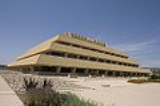
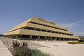 In 1971, a one-million square-foot ziggurat building, originally built for Rockwell International
and presently owned by the United States government, was designed by Los Angeles-based architect William Pereira
. The Chet Holifield Federal Building
, as it is now known, is home to millions of microfilms as documents of land agreements between the American government and the original Indian Tribes of the southwest United States. It is also home to the Western Regional Department of Homeland Security and the California Service Center of the United States Citizenship and Immigration Services
. The building was used for the 1995 movie Outbreak
, where it served as the exterior for the Center for Disease Control headquarters. Earlier, the building was featured in an ending scene for the 1975 sci-fi movie Death Race 2000
. It also served as the headquarters for the Luckup Corporation in the 1983 movie Deal of the Century
.
.
It is served by:
Elementary schools
Middle schools
High schools
Colleges
Private schools
South Peak, Crest de Ville, Niguel Coast, Palmilla, and Monarch Point, which offer city, canyon, and ocean views. Other major neighborhoods include Rancho Niguel, Marina Hills, Niguel West
, Niguel Summit, Beacon Hill, El Niguel Heights, Kite Hill, and San Joaquin Hills
.
Orange County, California
Orange County is a county in the U.S. state of California. Its county seat is Santa Ana. As of the 2010 census, its population was 3,010,232, up from 2,846,293 at the 2000 census, making it the third most populous county in California, behind Los Angeles County and San Diego County...
, California
California
California is a state located on the West Coast of the United States. It is by far the most populous U.S. state, and the third-largest by land area...
. The name "Laguna Niguel" is derived from the Spanish word "Laguna" which means lagoon
Lagoon
A lagoon is a body of shallow sea water or brackish water separated from the sea by some form of barrier. The EU's habitat directive defines lagoons as "expanses of shallow coastal salt water, of varying salinity or water volume, wholly or partially separated from the sea by sand banks or shingle,...
, and the word "Nigueli" which was the name of a Juaneño
Juaneño
The Juaneño or Acagchemem are a Native American group from Southern California. The Juaneño lived in what is now part of Orange and San Diego Counties and received their Spanish name from the priests of the California mission chain due to their proximity to Mission San Juan Capistrano...
Indian village that was once located on Aliso Creek. The population was 62,979 at the 2010 census, up from 61,891 at the 2000 census. The city was primarily built after 1980 as an unincorporated master planned community located in the San Joaquin Hills
San Joaquin Hills
The San Joaquin Hills are a set of low hills in coastal Orange County, California. They extend in a northwest-southeast direction, starting in the northwest in Newport Beach at the southern edge of the Los Angeles Basin, and extending southeast to San Juan Capistrano.-Geography and habitats:Named...
near Laguna Beach. Laguna Niguel contains a large range of housing, from condominiums to large mansions above the ocean. It borders Laguna Beach, Dana Point, San Juan Capistrano, Mission Viejo, Laguna Hills, and Aliso Viejo
Aliso Viejo, California
Aliso Viejo is a city in Orange County, California. It had a population of 47,823 as of the 2010 census, up from 40,166 as of the 2000 census. It became Orange County's 34th city on July 1, 2001, the only city in the county to incorporate since 2000...
.
History
Laguna Niguel is located on the Rancho NiguelRancho Niguel
Rancho Niguel was a Mexican land grant in present day Orange County, California given in 1842 by Governor Juan B. Alvarado to Juan Avila. The rancho was named for a local Indian village called "Niguili." The grant extended along the Pacific coast from Laguna Canyon and Laguna Beach, past Aliso...
Mexican land grant
Ranchos of California
The Spanish, and later the Méxican government encouraged settlement of territory now known as California by the establishment of large land grants called ranchos, from which the English ranch is derived. Devoted to raising cattle and sheep, the owners of the ranchos attempted to pattern themselves...
of Juan Avila. He retained ownership until 1865, when a severe drought killed off most of his cattle. Lewis Moulton, owner of the Moulton Company, bought the area of modern-day Laguna Niguel in 1895, along with significant other portions of the surrounding area from farmers that were hard pressed to earn a living due to a local drought in the area.
In 1959, the Laguna Niguel Corporation, started by Cabot, Cabot & Forbes
Cabot, Cabot & Forbes
Cabot, Cabot & Forbes was founded by Francis Murray Forbes in 1897 as a real estate management firm. It is one of Boston's larges firms in that industry., with interests on a nationwide basis.Notable American business leaders who have worked at this firm:...
from Boston
Boston
Boston is the capital of and largest city in Massachusetts, and is one of the oldest cities in the United States. The largest city in New England, Boston is regarded as the unofficial "Capital of New England" for its economic and cultural impact on the entire New England region. The city proper had...
, made Laguna Niguel one of the first master planned communities in California. Victor Gruen and Associates
Victor Gruen
Victor David Gruen, born Viktor David Grünbaum , was an Austrian-born commercial architect best known as a pioneer in the design of shopping malls in the United States.- Biography :...
, a Vienna architect, developed a community plan for 7100 acres (28.7 km²). The Avco Community Developer in 1969 continued the plan, which by then held 6,500 residents.
The construction of the San Diego, I-5, Freeway in 1959 allowed more people to arrive. The first communities developed in Laguna Niguel were right along the coast, touching the southern border of Laguna Beach. These communities were called Monarch Bay and the Monarch Bay Terrace built between 1960 and 1962.
In 1973, Laguna Niguel Regional Park opened, and in 1974 a one-million square-foot ziggurat building was given to the United States government.
On December 1, 1989, Laguna Niguel became an incorporated city in Orange County and became its 29th city.
Geography
Laguna Niguel is located at 33°31′55"N 117°42′9"W (33.531938, -117.702503). According to the United States Census BureauUnited States Census Bureau
The United States Census Bureau is the government agency that is responsible for the United States Census. It also gathers other national demographic and economic data...
, the city
City
A city is a relatively large and permanent settlement. Although there is no agreement on how a city is distinguished from a town within general English language meanings, many cities have a particular administrative, legal, or historical status based on local law.For example, in the U.S...
has a total area of 14.9 square miles (38.6 km²). 14.8 square miles (38.3 km²) of it is land and 0.05 square mile (0.1294994055 km²) of it (0.35%) is water.
Laguna Niguel occupies a hilly basin near the southern end of the San Joaquin Hills
San Joaquin Hills
The San Joaquin Hills are a set of low hills in coastal Orange County, California. They extend in a northwest-southeast direction, starting in the northwest in Newport Beach at the southern edge of the Los Angeles Basin, and extending southeast to San Juan Capistrano.-Geography and habitats:Named...
, a small coastal mountain range in southern Orange County. On the west is 650 feet (198.1 m) Niguel Hill, which separates the city from Aliso Canyon
Aliso Canyon
Aliso Canyon is a canyon cut through the San Joaquin Hills by Aliso Creek. Located in Orange County in the U.S. state of California, the canyon's name derives from the Spanish word for alder....
, an immense gorge cut by Aliso Creek, one of the county's primary watercourses. The Aliso Canyon area is home to Aliso and Wood Canyons Regional Park, a large wilderness area in the southern county. Although the creek itself only brushes the northwestern border of the city, a major tributary, Sulphur Creek
Sulphur Creek (California)
Sulphur Creek is a tributary of Aliso Creek in Orange County in the U.S. state of California. Draining about of mostly residential land in the southern San Joaquin Hills, it is the creek's largest tributary....
, drains most of northern Laguna Niguel. Sulphur Creek runs through Crown Valley in eastern Laguna Niguel, Crown Valley Park, Laguna Niguel Regional Park
Laguna Niguel Regional Park
Laguna Niguel Regional Park is a public park in Laguna Niguel, in southern Orange County, California. Its main feature is Sulphur Creek Reservoir, located within the park's boundaries.Laguna Niguel's 4th of July fireworks show is held at the park every year....
and Sulphur Creek Reservoir
Sulphur Creek Reservoir
Sulphur Creek Reservoir is an artificial fishing and recreational lake in Laguna Niguel, California. It is created by the Sulphur Creek Dam, which was completed in 1966. It is located at and is above sea level. It is fed from two sources, one of which is Sulphur Creek itself and one is a storm...
(Laguna Niguel Lake). The two parks and the lake lie just north of the geographic center of the city.
Dana Point, California
-Climate:Dana Point enjoys a mild climate where temperatures tend to average around the 60's. The warmest month of the year is August with an average temperature of 79 degrees Fahrenheit. The coldest month is December with an average minimum temperature of 44 degrees Fahrenheit.-2010:The 2010...
to the south separates Laguna Niguel and the Pacific. On the east side, Laguna Niguel is separated from San Juan Capistrano
San Juan Capistrano, California
San Juan Capistrano is a city in southern Orange County, California, located approximately southeast of Downtown Santa Ana. The current OMB metropolitan designation for San Juan Capistrano and the Orange County Area is “Santa Ana-Anaheim-Irvine, CA.” The population was 34,593 at the 2010 census,...
by a significant ridge running along Trabuco Creek
Trabuco Creek
Trabuco Creek is a small river in the U.S. state of California, flowing from the westernmost extreme of Riverside County through Orange County to join San Juan Creek in the city of San Juan Capistrano. long, its watershed covers in southeastern Orange County, including portions of three...
. To the north lie Aliso Viejo
Aliso Viejo, California
Aliso Viejo is a city in Orange County, California. It had a population of 47,823 as of the 2010 census, up from 40,166 as of the 2000 census. It became Orange County's 34th city on July 1, 2001, the only city in the county to incorporate since 2000...
and Laguna Hills
Laguna Hills, California
Laguna Hills is a city located in southern Orange County, California, United States. Its name refers to its proximity to Laguna Canyon and the much older Laguna Beach. Other newer cities nearby—Laguna Niguel and Laguna Woods—are similarly named.-Geography:...
.
Crown Valley and Alicia Parkways are the primary thoroughfares in the city. Crown Valley Parkway runs along Sulphur Creek and the northern fork of Salt Creek, bisecting the city northeast to southwest. Alicia Parkway, mostly a north-south road, follows Aliso Creek to where it joins Crown Valley Parkway in close proximity to Crown Valley Park and the city center. California State Route 73
California State Route 73
State Route 73 is a state highway in the U.S. state of California. The route runs from Interstate 405 to Interstate 5 through the San Joaquin Hills in Orange County. From its northern terminus, the first three miles of the highway are called the Corona del Mar Freeway; this section of highway...
runs north of the city, diverging from Interstate 5
Interstate 5
Interstate 5 is the main Interstate Highway on the West Coast of the United States, running largely parallel to the Pacific Ocean coastline from Canada to Mexico . It serves some of the largest cities on the U.S...
just northeast of Laguna Niguel. Moulton Parkway/Street of the Golden Lantern runs along the eastern boundary of Laguna Niguel. Pacific Island Drive/Camino del Avión follow parts of the west and south boundaries, respectively. Another major road, Niguel Road, runs roughly parallel and east of Crown Valley Parkway along the Salt Creek canyon. Marina Hills Drive is the largest crossing between Niguel Road and Golden Lantern, and Aliso Creek Road runs east-west through northern Laguna Niguel.
2010
The 2010 United States Census reported that Laguna Niguel had a population of 62,979. The population densityPopulation density
Population density is a measurement of population per unit area or unit volume. It is frequently applied to living organisms, and particularly to humans...
was 4,231.1 people per square mile (1,633.6/km²). The racial makeup of Laguna Niguel was 50,625 (80.4%) White, 777 (1.2%) African American, 219 (0.3%) Native American, 5,459 (8.7%) Asian, 87 (0.1%) Pacific Islander, 3,019 (4.8%) from other races
Race (United States Census)
Race and ethnicity in the United States Census, as defined by the Federal Office of Management and Budget and the United States Census Bureau, are self-identification data items in which residents choose the race or races with which they most closely identify, and indicate whether or not they are...
, and 2,793 (4.4%) from two or more races. Hispanic or Latino of any race were 8,761 persons (13.9%).
The Census reported that 62,731 people (99.6% of the population) lived in households, 248 (0.4%) lived in non-institutionalized group quarters, and 0 (0%) were institutionalized.
There were 24,232 households, out of which 8,085 (33.4%) had children under the age of 18 living in them, 14,077 (58.1%) were opposite-sex married couples
Marriage
Marriage is a social union or legal contract between people that creates kinship. It is an institution in which interpersonal relationships, usually intimate and sexual, are acknowledged in a variety of ways, depending on the culture or subculture in which it is found...
living together, 2,271 (9.4%) had a female householder with no husband present, 886 (3.7%) had a male householder with no wife present. There were 994 (4.1%) unmarried opposite-sex partnerships
POSSLQ
POSSLQ is an abbreviation for "Persons of Opposite Sex Sharing Living Quarters," a term coined in the late 1970s by the United States Census Bureau as part of an effort to more accurately gauge the prevalence of cohabitation in American households....
, and 237 (1.0%) same-sex married couples or partnerships. 5,390 households (22.2%) were made up of individuals and 1,790 (7.4%) had someone living alone who was 65 years of age or older. The average household size was 2.59. There were 17,234 families
Family (U.S. Census)
A family or family household is defined by the United States Census Bureau for statistical purposes as "a householder and one or more other people related to the householder by birth, marriage, or adoption. They do not include same-sex married couples even if the marriage was performed in a state...
(71.1% of all households); the average family size was 3.06.
The population was spread out with 14,216 people (22.6%) under the age of 18, 4,722 people (7.5%) aged 18 to 24, 14,667 people (23.3%) aged 25 to 44, 21,177 people (33.6%) aged 45 to 64, and 8,197 people (13.0%) who were 65 years of age or older. The median age was 42.8 years. For every 100 females there were 94.0 males. For every 100 females age 18 and over, there were 91.2 males.
There were 25,312 housing units at an average density of 1,700.5 per square mile (656.6/km²), of which 17,453 (72.0%) were owner-occupied, and 6,779 (28.0%) were occupied by renters. The homeowner vacancy rate was 0.9%; the rental vacancy rate was 5.4%. 45,029 people (71.5% of the population) lived in owner-occupied housing units and 17,702 people (28.1%) lived in rental housing units.
2000
As of the censusCensus
A census is the procedure of systematically acquiring and recording information about the members of a given population. It is a regularly occurring and official count of a particular population. The term is used mostly in connection with national population and housing censuses; other common...
of 2000, there were 61,891 people, 23,217 households, and 16,785 families residing in the city. The population density
Population density
Population density is a measurement of population per unit area or unit volume. It is frequently applied to living organisms, and particularly to humans...
was 4,221.0 inhabitants per square mile (1,630.0/km²). There were 23,885 housing units at an average density of 1,629.0 per square mile (629.1/km²). The racial makeup of the city was 83.50% White, 1.25% African American, 0.29% Native American, 7.73% Asian, 0.12% Pacific Islander, 3.48% from other races
Race (United States Census)
Race and ethnicity in the United States Census, as defined by the Federal Office of Management and Budget and the United States Census Bureau, are self-identification data items in which residents choose the race or races with which they most closely identify, and indicate whether or not they are...
, and 3.62% from two or more races. Hispanic or Latino of any race were 10.38% of the population.
There were 23,217 households out of which 38.1% had children under the age of 18 living with them, 60.2% were married couples
Marriage
Marriage is a social union or legal contract between people that creates kinship. It is an institution in which interpersonal relationships, usually intimate and sexual, are acknowledged in a variety of ways, depending on the culture or subculture in which it is found...
living together, 8.8% had a female householder with no husband present, and 27.7% were non-families. 20.6% of all households were made up of individuals and 4.7% had someone living alone who was 65 years of age or older. The average household size was 2.65 and the average family size was 3.10.
In the city the population was spread out with 26.6% under the age of 18, 6.0% from 18 to 24, 32.9% from 25 to 44, 25.7% from 45 to 64, and 8.9% who were 65 years of age or older. The median age was 38 years. For every 100 females there were 94.9 males. For every 100 females age 18 and over, there were 91.2 males.
According to the Census Bureau's 2008 estimate, the median income for a household in the city was $98,072, and the median income for a family was $120,963. Males had a median income of $68,640 versus $40,487 for females. The per capita income
Per capita income
Per capita income or income per person is a measure of mean income within an economic aggregate, such as a country or city. It is calculated by taking a measure of all sources of income in the aggregate and dividing it by the total population...
for the city was $50,980. About 2.8% of families and 4.1% of the population were below the poverty line, including 3.6% of those under age 18 and 4.1% of those age 65 or over.
Top employers
According to the City's 2009 Comprehensive Annual Financial Report, the top employers in the city are:| # | Employer | # of employees |
|---|---|---|
| 1 | Costco Costco Costco Wholesale Corporation is the largest membership warehouse club chain in the United States. it is the third largest retailer in the United States, where it originated, and the ninth largest in the world... |
500 |
| 2 | Wal-Mart Wal-Mart Wal-Mart Stores, Inc. , branded as Walmart since 2008 and Wal-Mart before then, is an American public multinational corporation that runs chains of large discount department stores and warehouse stores. The company is the world's 18th largest public corporation, according to the Forbes Global 2000... |
280 |
| 3 | Capistrano Unified School District Capistrano Unified School District Capistrano Unified School District is the second largest school district in Orange County, California, the 12th largest in California and the 82nd largest in the United States. The district currently has 51,512 students... |
245 |
| 4 | Albertsons | 210 |
| 5 | The Home Depot The Home Depot The Home Depot is an American retailer of home improvement and construction products and services.The Home Depot operates 2,248 big-box format stores across the United States , Canada , Mexico and China, with a 12-store chain... |
200 |
| 6 | County of Orange Orange County, California Orange County is a county in the U.S. state of California. Its county seat is Santa Ana. As of the 2010 census, its population was 3,010,232, up from 2,846,293 at the 2000 census, making it the third most populous county in California, behind Los Angeles County and San Diego County... |
180 |
| 7 | First Team Real Estate | 140 |
| 8 | Calstar Properties | 125 |
| 9 | Kohl's Kohl's Kohl's Corporation is an American department store chain headquartered in the Milwaukee suburb of Menomonee Falls, Wisconsin, operating , 1,089 stores in 49 states. In 1998, it entered the S&P 500 list, and is also listed in the Fortune 500... |
121 |
| 10 | Pacific Line Clean Up | 120 |
Government and politics
The City Council consists of five members, elected from the City at-large, who serve four year staggered terms. Annually, the City Council appoints a Mayor and a Mayor Pro Tem from its own membership to serve a one-year term. Current incumbents are:- Gary Capata, Mayor (elected 2008)
- Paul Glaab, Mayor Pro Tem (elected 2008)
- Joe Brown, Council Member (elected 2008)
- Linda Lindholm, Council Member (elected 2010)
- Robert Ming, Council Member (elected 2010)
The city is currently in the process of building a permanent City Hall complex at the corner of Alicia Parkway and Crown Valley Parkway to replace the temporary City Hall on La Paz Road. Construction is expected to be completed in July 2011.
County, state and federal
In The Orange County Board of SupervisorsOrange County Board of Supervisors
The Orange County Board of Supervisors is the five-member governing body of Orange County, California.-Membership:The Board consists of five Supervisors elected by districts to four-year terms by the citizens of Orange County...
Laguna Niguel is part of the 5th District and represented by Patricia C. Bates. In the state legislature
California State Legislature
The California State Legislature is the state legislature of the U.S. state of California. It is a bicameral body consisting of the lower house, the California State Assembly, with 80 members, and the upper house, the California State Senate, with 40 members...
Laguna Niguel is located in the 33rd
California's 33rd State Senate district
California's 33rd State Senate District is one of 40 Senate Districts. It is currently represented by Republican Mimi Walters of Laguna Niguel.-District profile:...
Senate
California State Senate
The California State Senate is the upper house of the California State Legislature. There are 40 state senators. The state legislature meets in the California State Capitol in Sacramento. The Lieutenant Governor is the ex officio President of the Senate and may break a tied vote...
District, represented by Republican
Republican Party (United States)
The Republican Party is one of the two major contemporary political parties in the United States, along with the Democratic Party. Founded by anti-slavery expansion activists in 1854, it is often called the GOP . The party's platform generally reflects American conservatism in the U.S...
Mimi Walters
Mimi Walters
Mimi K. Walters is a Republican State Senator from the state of California, representing the 33rd District since 2008. She previously served in the Assembly for four years from 2004 to 2008, where she served in the Republican leadership as Assistant Republican Leader and Vice Chair of the...
, and in the 73rd
California's 73rd State Assembly district
California's 73rd State Assembly District is one of 80 districts in the California State Assembly. It is currently represented by Republican Diane Harkey of Dana Point.-District profile:Orange County - 7.98%*Aliso Viejo - 35.38%*Dana Point...
Assembly
California State Assembly
The California State Assembly is the lower house of the California State Legislature. There are 80 members in the Assembly, representing an approximately equal number of constituents, with each district having a population of at least 420,000...
District, represented by Republican Diane Harkey
Diane Harkey
Diane Lynn Harkey is a former Council Member and Mayor of the City of Dana Point, California. She is currently the Republican representative in California's 73rd State Assembly district.-Early years and education:...
. Federally, Laguna Niguel is located in California's 48th congressional district
California's 48th congressional district
California's 48th congressional district is a congressional district in the U.S. state of California based in Orange County in Southern California...
, which has a Cook PVI
Cook Partisan Voting Index
The Cook Partisan Voting Index , sometimes referred to as simply the Partisan Voting Index , is a measurement of how strongly an American congressional district or state leans toward one political party compared to the nation as a whole...
of R +8 and is represented by Republican John Campbell.
Climate
Like much of Southern California, Laguna Niguel has pleasant weather year-round. On average, August is the hottest month and December the coolest. The highest recorded temperature is 108°F, which occurred in 1963, and the lowest such temperature is 21°F, which was recorded in 1949. Precipitation is sparse in Laguna Niguel, as only five months out of the year receive rainfall greater than one inch. The highest monthly rainfall on average occurs in February and is 2.96 inches (75.2 mm).Notable buildings
Rockwell International
Rockwell International was a major American manufacturing conglomerate in the latter half of the 20th century, involved in aircraft, the space industry, both defense-oriented and commercial electronics, automotive and truck components, printing presses, valves and meters, and industrial automation....
and presently owned by the United States government, was designed by Los Angeles-based architect William Pereira
William Pereira
William Leonard Pereira was an American architect from Chicago, Illinois, of Portuguese ancestry who was noted for his futuristic designs of landmark buildings such as the Transamerica Pyramid in San Francisco...
. The Chet Holifield Federal Building
Chet Holifield Federal Building
The Chet Holifield Federal Building is a courthouse of the United States District Court for the Southern District of California constructed in Laguna Niguel, California between 1968 and 1971...
, as it is now known, is home to millions of microfilms as documents of land agreements between the American government and the original Indian Tribes of the southwest United States. It is also home to the Western Regional Department of Homeland Security and the California Service Center of the United States Citizenship and Immigration Services
United States Citizenship and Immigration Services
United States Citizenship and Immigration Services is a component of the United States Department of Homeland Security . It performs many administrative functions formerly carried out by the legacy United States Immigration and Naturalization Service , which was part of the Department of Justice...
. The building was used for the 1995 movie Outbreak
Outbreak (film)
Outbreak is a 1995 American disaster film starring Dustin Hoffman, Rene Russo, Morgan Freeman, and Kevin Spacey. The film was directed by Wolfgang Petersen. In addition, Outbreak features Cuba Gooding, Jr., Donald Sutherland, and Patrick Dempsey....
, where it served as the exterior for the Center for Disease Control headquarters. Earlier, the building was featured in an ending scene for the 1975 sci-fi movie Death Race 2000
Death Race 2000
Death Race 2000 is a 1975 cult action film directed by Paul Bartel, and starring David Carradine, Simone Griffeth and Sylvester Stallone. The film takes place in a dystopian American society in the year 2000, where the murderous Transcontinental Road Race has become a form of national entertainment...
. It also served as the headquarters for the Luckup Corporation in the 1983 movie Deal of the Century
Deal of the Century
Deal of the Century is a 1983 American comedy film directed by William Friedkin and starring Chevy Chase, Gregory Hines, and Sigourney Weaver.The film follows the adventures of several arms dealers that compete to sell weapons to a South American dictator....
.
Education
The city is served by the Capistrano Unified School DistrictCapistrano Unified School District
Capistrano Unified School District is the second largest school district in Orange County, California, the 12th largest in California and the 82nd largest in the United States. The district currently has 51,512 students...
.
It is served by:
Elementary schools
- Moulton Elementary School
- Marian Bergeson Elementary
- Crown Valley Elementary School
- Hidden Hills Elementary School
- Laguna Niguel Elementary School
- Malcolm Elementary School
- George White Elementary School
Middle schools
- Niguel Hills Middle SchoolNiguel Hills Middle SchoolNiguel Hills Middle School is located in Laguna Niguel, California. It opened in 1975 and teaches grade levels 6 to 8 and is a blue ribbon school. The school belongs to the Capistrano Unified School District.-External links:*...
- Aliso Viejo Middle SchoolAliso Viejo Middle SchoolAliso Viejo Middle School is located in Aliso Viejo, California, and typically enrolls between 1,100 and 1,200 students total. The student body consists of 6th, 7th, and 8th graders. Its principal is Jennifer Garrett-Smalley, and it is located in the Capistrano Unified School District...
(in Aliso Viejo)
High schools
- Aliso Niguel High SchoolAliso Niguel High SchoolAliso Niguel High School is a high school located in the city of Aliso Viejo, California, U.S. Most of its students reside in the communities of Aliso Viejo and Laguna Niguel. The school is a California Distinguished School, a National Blue Ribbon School, and a New American High School...
(in Aliso Viejo) - Dana Hills High SchoolDana Hills High SchoolDana Hills High School is a high school in Dana Point, California. It is one of the oldest high schools in South Orange County, having opened in 1973...
(in Dana Point)
Colleges
- Saddleback CollegeSaddleback CollegeThe athletic programs are supported in part by the Associated Student Body at Saddleback College. Revenue generated from attendance at athletic events helps support the entire student activities program.-On-campus media outlets:*The Lariat...
(in Mission Viejo - Served by the South Orange County Community College DistrictSouth Orange County Community College DistrictSouth Orange County Community College District , founded in 1967, has three separate campuses: Saddleback College in Mission Viejo, California, Irvine Valley College in Irvine, California and the Advanced Technology & Education Park in Tustin, California. The District is governed by a seven-member...
) - Chapman UniversityChapman UniversityChapman University is a private, non-profit university located in Orange, California affiliated with the Christian Church . Known for its blend of liberal arts and professional programs, Chapman University encompasses seven schools and colleges: Lawrence and Kristina Dodge College of Film and Media...
(in Orange) - Soka University of AmericaSoka University of AmericaSoka University of America is a university located in Aliso Viejo, California, United States. It describes its mission as the fostering of a steady stream of global citizens committed to living a contributive life—with an emphasis on principles of pacifism, human rights, and the creative...
(in Aliso Viejo) - University of California, IrvineUniversity of California, IrvineThe University of California, Irvine , founded in 1965, is one of the ten campuses of the University of California, located in Irvine, California, USA...
(in Irvine) - California State University, FullertonCalifornia State University, FullertonCalifornia State University, Fullerton is a public university located in Fullerton, California. It is the largest institution in the CSU System by enrollment, it offers long-distance education and adult-degree programs...
(in Irvine) - California State University, FullertonCalifornia State University, FullertonCalifornia State University, Fullerton is a public university located in Fullerton, California. It is the largest institution in the CSU System by enrollment, it offers long-distance education and adult-degree programs...
(in Fullerton)
Private schools
- St. Anne School
Points of interest
Over one-third of Laguna Niguel is designated as open space. Major parks in the city include:- Aliso/Wood Canyons Regional Park
- Badlands Park
- Laguna Niguel Regional Park
Neighborhoods
Laguna Niguel is home to many upscale neighborhoods including Bear Brand Ranch, Ocean Ranch, Coronado Pointe,South Peak, Crest de Ville, Niguel Coast, Palmilla, and Monarch Point, which offer city, canyon, and ocean views. Other major neighborhoods include Rancho Niguel, Marina Hills, Niguel West
Niguel West
Niguel West is a neighborhood of 101 houses in Laguna Niguel, California near the intersection of Crown Valley Parkway and Camino Del Avion. The neighborhood is divided into two sections: Niguel West I and Niguel West II.-How to get there:...
, Niguel Summit, Beacon Hill, El Niguel Heights, Kite Hill, and San Joaquin Hills
San Joaquin Hills (Laguna Niguel, California)
San Joaquin Hills is an affluent guard gated master planned community in the city of Laguna Niguel, California in the San Joaquin Hills of Orange County, California. The community is set in the northernmost foothills of the city of Laguna Niguel, and construction began in 1997 after a 1994 approval...
.