
El Toro Y
Encyclopedia
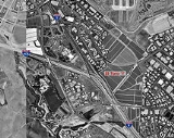
The El Toro "Y" is a freeway interchange in southern Orange County, California
where the Santa Ana Freeway
, Interstate 5, and the San Diego Freeway, Interstate 405
merge. South of that point, it retains the name "San Diego Freeway" but with the highway
designation "Interstate 5." Located in southeastern Irvine
, the interchange was named for the now closed Marine Corps Air Station El Toro
, located north of the interchange.
The "Y" is one of the busiest interchanges in the world; from 1975 to 2002, daily traffic surged from 102,000 to 356,000 vehicles a day.
In November 1990, Orange County voters approved Measure M, a half-cent increase in the county sales tax
to finance transportation improvements. In 1993, the California Department of Transportation
(Caltrans) began a massive expansion project, adding a new interchange and collector/distributor roads at Bake Parkway (signed as truck bypass lanes) and Lake Forest
Drive, and carpool lanes and connectors. The $166-million project also vastly increased regular traffic lanes. After the project was completed in 1997, the El Toro Y stood as one of the widest roads in the world, at 26 traffic lanes wide.
The traffic delays at the interchange sparked the construction of several parallel bypass toll road
s. The San Joaquin Hills Toll Road, designated State Route 73, opened in November 1996 and connects San Juan Capistrano
and Costa Mesa
. An extension to State Route 241, the Foothill Toll Road
, is under development. It would bypass the El Toro Y to the east and connect to I-5 in northern San Diego County
.
In the cleft of the Y lies the Irvine Spectrum Center
, a huge shopping center which includes a movie theater, numerous shopping destinations and a large obelisk, which conceals a cell phone and television tower inside of it.
On July 29, 2008 a moderate earthquake centered in Chino Hills
caused damage to an expansion joint on one of the overpasses in the interchange. Caltrans closed the I-5 Southbound Truck Bypass/Bake Parkway/Lake Forest exit, to replace the expansion joint that was damaged during the quake.
Orange County, California
Orange County is a county in the U.S. state of California. Its county seat is Santa Ana. As of the 2010 census, its population was 3,010,232, up from 2,846,293 at the 2000 census, making it the third most populous county in California, behind Los Angeles County and San Diego County...
where the Santa Ana Freeway
Santa Ana Freeway
The Santa Ana Freeway is one of the principal freeways in Southern California, connecting Los Angeles and its southeastern suburbs including the freeway's namesake, the city of Santa Ana. The freeway begins at the Four Level Interchange in downtown Los Angeles, signed as U.S. Route 101...
, Interstate 5, and the San Diego Freeway, Interstate 405
Interstate 405 (California)
Interstate 405 is a major north–south Interstate Highway in Southern California. It is a bypass of Interstate 5, running along the western areas of the Greater Los Angeles Area from Irvine in the south to near San Fernando in the north...
merge. South of that point, it retains the name "San Diego Freeway" but with the highway
Highway
A highway is any public road. In American English, the term is common and almost always designates major roads. In British English, the term designates any road open to the public. Any interconnected set of highways can be variously referred to as a "highway system", a "highway network", or a...
designation "Interstate 5." Located in southeastern Irvine
Irvine, California
Irvine is a suburban incorporated city in Orange County, California, United States. It is a planned city, mainly developed by the Irvine Company since the 1960s. Formally incorporated on December 28, 1971, the city has a population of 212,375 as of the 2010 census. However, the California...
, the interchange was named for the now closed Marine Corps Air Station El Toro
Marine Corps Air Station El Toro
Marine Corps Air Station El Toro was a United States Marine Corps Air Station located near Irvine, California.Before it was decommissioned in 1999, it was the home of Marine Corps aviation on the West Coast. Designated as a Master Jet Station, its four runways could handle the largest aircraft...
, located north of the interchange.
The "Y" is one of the busiest interchanges in the world; from 1975 to 2002, daily traffic surged from 102,000 to 356,000 vehicles a day.
History
By the early 1990s the El Toro Y had become one of the most congested freeway interchanges in the world, its severe overcrowding fed by a housing boom in southern Orange County.In November 1990, Orange County voters approved Measure M, a half-cent increase in the county sales tax
Sales tax
A sales tax is a tax, usually paid by the consumer at the point of purchase, itemized separately from the base price, for certain goods and services. The tax amount is usually calculated by applying a percentage rate to the taxable price of a sale....
to finance transportation improvements. In 1993, the California Department of Transportation
California Department of Transportation
The California Department of Transportation is a government department in the U.S. state of California. Its mission is to improve mobility across the state. It manages the state highway system and is actively involved with public transportation systems throughout the state...
(Caltrans) began a massive expansion project, adding a new interchange and collector/distributor roads at Bake Parkway (signed as truck bypass lanes) and Lake Forest
Lake Forest, California
Lake Forest is a city in Orange County, California. The population was 77,264 at the 2010 census.Lake Forest incorporated as a city on December 20, 1991. Prior to a vote of the residents in that year, the community had formerly been known as El Toro since the 1880s...
Drive, and carpool lanes and connectors. The $166-million project also vastly increased regular traffic lanes. After the project was completed in 1997, the El Toro Y stood as one of the widest roads in the world, at 26 traffic lanes wide.
The traffic delays at the interchange sparked the construction of several parallel bypass toll road
Toll road
A toll road is a privately or publicly built road for which a driver pays a toll for use. Structures for which tolls are charged include toll bridges and toll tunnels. Non-toll roads are financed using other sources of revenue, most typically fuel tax or general tax funds...
s. The San Joaquin Hills Toll Road, designated State Route 73, opened in November 1996 and connects San Juan Capistrano
San Juan Capistrano, California
San Juan Capistrano is a city in southern Orange County, California, located approximately southeast of Downtown Santa Ana. The current OMB metropolitan designation for San Juan Capistrano and the Orange County Area is “Santa Ana-Anaheim-Irvine, CA.” The population was 34,593 at the 2010 census,...
and Costa Mesa
Costa Mesa, California
Costa Mesa is a city in Orange County, California. The population was 109,960 at the 2010 census. Since its incorporation in 1953, the city has grown from a semi-rural farming community of 16,840 to a primarily suburban and "edge" city with an economy based on retail, commerce, and light...
. An extension to State Route 241, the Foothill Toll Road
California State Route 241
State Route 241 is a state highway in the U.S. state of California. For its entire run, Route 241 is a toll road. Its northern half is part of the Eastern Toll Road while its southern half is part of the Foothill Toll Road....
, is under development. It would bypass the El Toro Y to the east and connect to I-5 in northern San Diego County
San Diego County, California
San Diego County is a large county located in the southwestern corner of the US state of California. Hence, San Diego County is also located in the southwestern corner of the 48 contiguous United States. Its county seat and largest city is San Diego. Its population was about 2,813,835 in the 2000...
.
In the cleft of the Y lies the Irvine Spectrum Center
Irvine Spectrum Center
The Irvine Spectrum Center is a large outdoor shopping mall on the south-east edge of Irvine, California, centered on a large Edwards 21 Cinemas movie theater. Built over a 10-year period, the first phase of the mall opened in 1995, with the second phase following soon after in 1998. The third...
, a huge shopping center which includes a movie theater, numerous shopping destinations and a large obelisk, which conceals a cell phone and television tower inside of it.
On July 29, 2008 a moderate earthquake centered in Chino Hills
2008 Chino Hills earthquake
The 2008 Chino Hills earthquake occurred at 11:42:15 a.m. PDT on July 29, 2008, in Southern California. The epicenter of the magnitude 5.5 earthquake was in Chino Hills, approximately east-southeast of downtown Los Angeles....
caused damage to an expansion joint on one of the overpasses in the interchange. Caltrans closed the I-5 Southbound Truck Bypass/Bake Parkway/Lake Forest exit, to replace the expansion joint that was damaged during the quake.