
California State Route 241
Encyclopedia
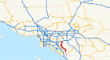
State Route 241 is a state highway in the U.S. state
of California
. For its entire run, Route 241 is a toll road
. Its northern half is part of the Eastern Toll Road
while its southern half is part of the Foothill Toll Road.
The highway currently runs from Rancho Santa Margarita
to Yorba Linda
. Route 241 connects with State Route 133
, State Route 261
, and State Route 91
.
 This route is part of the California Freeway and Expressway System
.
The Foothill Toll Road (also called The Foothill Transportation Corridor) is a 12 miles (19.3 km) tollway in Orange County. Signed as State Route 241, it travels parallel
to Interstate 5, connecting the Eastern Toll Road
(at the State Route 133/State Route 241 interchange) outside of Irvine
with Oso Parkway near Mission Viejo
.
The toll road was constructed by the Transportation Corridor Agencies
, also known as the TCA, and is owned by the state of California. Construction was financed with bonds, which are repaid with toll revenues. Taxpayers are not responsible for repaying any debt if toll revenues fall short.
The route begins at Oso Parkway near Rancho Santa Margarita
and heads northward. The toll road enters Rancho Santa Margarita, crossing El Toro Road without an exit. Heading north, SR 241 passes through Irvine
before meeting SR 133
, another toll road. The freeway meets SR 261
near Irvine Lake before turning northeastward. SR 241 meets its terminus at SR 91
near the Santa Ana River
.
The extension would provide an alternate route to Interstate 5 for those traveling from Riverside, Corona and southeast Orange County to points southward as well as those traveling from North San Diego County
northward. Proponents of the project, including a coalition of chambers of commerce, argue it would provide greater access for communities such as Foothill Ranch
, Rancho Santa Margarita
, Las Flores, Coto de Caza
, Wagon Wheel and the future Rancho Mission Viejo. The TCA Board of Directors, local elected officials who represent the areas adjacent to the toll road routes, certified the project's Environmental Impact Report in 2006.
The route was selected by a collaborative group that included the Federal Highway Administration
, Environmental Protection Agency
, Fish & Wildlife Service
, the Army Corps of Engineers
and Caltrans.
The route would extend the toll road to connect to Interstate 5 at the San Diego County
line near San Onofre, where the TCA projects traffic to increase 60 percent by 2025. The final four miles (6 km) of the roadway would be located on Camp Pendleton Marine Base
. The road would go through a section of the San Onofre State Park
, which is leased from the United States Marine Corps
. The Marine Corps reserved the right to grant easements for rights of way when the lease with the California Department of Parks and Recreation
was signed in 1971.
The TCA estimates that by 2025, Foothill-South would carry 58,000 vehicles per day. This would represent about 13% of the estimated 460,000 cars per day on the I-5 by that time.
On February 6, 2008, the California Coastal Commission
voted 8-2 to reject a 16 miles (25.7 km) southern segment of the 241, Foothill-South, which was planned for the Foothill Toll Road. The TCA
appealed the Coastal Commission's decision to the U.S. Secretary of Commerce. On December 18, 2008, the Department of Commerce announced that it would uphold the California Coastal Commission’s ruling that found the TCA’s proposed extension of the 241 Toll Road inconsistent with the California Coastal Act. In a release issued by the Department of Commerce, the DOC noted that at least one reasonable alternative to the project existed, and that the project was not necessary in the interest of national security.
. Former California Attorney General Bill Lockyer
filed two lawsuits in 2006, one on behalf of the Native American Heritage Commission. A third lawsuit was filed by a coalition of several groups, including Sierra Club
, the Surfrider Foundation, Natural Resources Defense Council
.
One area of concern for those opposed is how well the project will avoid Native American
sites in the area, such as the ancient Acjachemen village of Panhe. The TCA asserts it will avoid these sites, but this is disputed by opponents. The road as conceived would bridge over San Mateo Creek as the existing Interstate 5, old Highway 1 and train tracks currently do.
Opponents of the proposed extension are also concerned about possible damage to water quality, and the disruption of wave quality at Trestles
, a world famous surfing spot. In response, the TCA claims that mitigation techniques will eliminate any negative effect on water quality, and that the proposed detention basin
s will in addition capture runoff from a two-mile (3 km) portion of the I-5 which is currently untreated. Studies have determined that there will be no effect on wave quality at Trestles. The independence of all these studies is in dispute.
. They also claim that Interstate 15 generally does not suffer from significant congestion.
Another concern of the project's opponents is the non-compete clause
which the TCA has signed with the California Department of Transportation
, or Caltrans. The clause requires Caltrans to compensate the TCA for lost revenue caused by highway improvements which might compete with the tollways, thereby reducing toll revenue. The clause expires in 2020. Opponents of the expansion argue that the non-compete clause makes improvements to Interstate 5 highly unlikely until at least 2020. In response to this, the TCA claims that traffic removed from the I-5 by the addition of Foothill-South will reduce congestion on the I-5 without the need for additional upgrades. Additionally, the non-compete clause does not apply to any improvements which have already been specified by the OCTA in Measure M transportation funds.
An alternate route for Foothill-South has been proposed by opponents of the San Onofre-bound extension. The "beltway" alternative would continue south past Oso Parkway as planned but would then turn westward north of Ortega Highway
and continue between the communities of San Juan Capistrano and Ladera Ranch before meeting Interstate 5
and California State Route 73
in southwest Mission Viejo. Proponents claim that this alignment will connect residential areas in Southeast Orange County to job centers to the Northwest through Route 73, while also alleviating congestion on Interstate 5 from San Juan Capistrano to Irvine. However, proponents acknowledge that a widening of Interstate 5 south of the beltway interchange would be necessary to alleviate congestion south of Mission Viejo. The U.S. Federal Highway Administration conducted an analysis of the project opponents' I-5 widening plan (known as "Smart Mobility") and deemed it "not reasonable and feasible." Caltrans Director Will Kempton stated at the February 2008 Coastal Commission meeting that the opponents' Smart Mobility plan to widen I-5 "did not comply with our (Caltrans) design standards. Safety issues were not considered."
As an alternative to Foothill-South, opponents generally argue that transportation dollars should be spent on a major upgrade to Interstate 5, and on improving mass transit in the area, such as the existing Metrolink
line which terminates at Oceanside
. Kempton went on to say, “We cannot compromise safety in the construction of our transportation infrastructure.” The U.S. Federal Highway Administration and Caltrans agree that widening the I-5 would cost more than $2.5 billion and would result in the demolition of more than 1,000 homes and businesses.
The entire route is in Orange County
.
{| class=wikitable
!Location
!Postmile
!Exit
!Destinations
!Notes
|-
|
|14.55
|14
|Oso Parkway
|Southbound exit and northbound entrance
|-
|rowspan=3|Rancho
Santa Margarita
|17.77
|18
|Antonio Parkway
|
|-
|18.49
|19
|Santa Margarita Parkway
|
|-
|20.08
|20
|Los Alisos Boulevard
|
|-
|rowspan=3|Lake Forest
|21.80
|22A
|Portola Parkway
|Signed as exit 22 northbound
|-bgcolor=#ffdddd
|
|22B
|Lake Forest Drive
|Southbound exit and northbound entrance
|-
|23.42
|23
|Alton Parkway
|
|-
|Irvine
|24.97
|25
|Portola Parkway – Irvine
|
|-
|colspan=5 align=center|Tomato Springs toll plaza
|-
|
|27.38
|27
|
|
|-
|
|32.54
|33
|Santiago Canyon Road, Chapman Avenue (CR S18, CR S25)
|
|-
|
|bgcolor=#ffdddd|
|bgcolor=#ffdddd|32
|bgcolor=#ffdddd|
|bgcolor=#ffdddd|No northbound exit
|-
|
|36.10
|colspan=3 align=center|Windy Ridge toll plaza
|-
|Anaheim
, Yorba Linda
|39.08
|39
|
|Northbound exit and southbound entrance; signed as exits 39A (east) and 39B (west)
U.S. state
A U.S. state is any one of the 50 federated states of the United States of America that share sovereignty with the federal government. Because of this shared sovereignty, an American is a citizen both of the federal entity and of his or her state of domicile. Four states use the official title of...
of California
California
California is a state located on the West Coast of the United States. It is by far the most populous U.S. state, and the third-largest by land area...
. For its entire run, Route 241 is a toll road
Toll road
A toll road is a privately or publicly built road for which a driver pays a toll for use. Structures for which tolls are charged include toll bridges and toll tunnels. Non-toll roads are financed using other sources of revenue, most typically fuel tax or general tax funds...
. Its northern half is part of the Eastern Toll Road
Eastern Toll Road (California)
Eastern Toll Road may refer to:* California State Route 261, connecting 241 and Interstate 5* California State Route 133, in southern California* California State Route 241, part of both the Eastern Toll Road and the Foothill Toll Road...
while its southern half is part of the Foothill Toll Road.
The highway currently runs from Rancho Santa Margarita
Rancho Santa Margarita, California
Rancho Santa Margarita is a city in Orange County, California. One of Orange County's youngest cities, Rancho Santa Margarita is a master planned community set upon rolling hills. Most neighborhoods in Rancho Santa Margarita are within various homeowners associations...
to Yorba Linda
Yorba Linda, California
Yorba Linda is a suburban city in northeastern Orange County, California, approximately northeast of Downtown Santa Ana, and southeast of Downtown Los Angeles....
. Route 241 connects with State Route 133
California State Route 133
State Route 133 is a state highway in the U.S. state of California. It connects SR 1 in Laguna Beach through the San Joaquin Hills with several freeways in Irvine, ending at the SR 241 toll road in the latter city...
, State Route 261
California State Route 261
State Route 261 is a tollway in the U.S. state of California that is part of the Eastern Transportation Corridor system. It connects State Route 241 with Interstate 5...
, and State Route 91
California State Route 91
State Route 91 is a major east–west freeway located entirely within Southern California and serving several regions of the Greater Los Angeles metropolitan area...
.
Route description
California Freeway and Expressway System
The California Freeway and Expressway System is a system of existing or planned freeways and expressways in the U.S. state of California. It is defined by the Streets and Highways Code.-List of roads in the system:*State Route 1 *State Route 2...
.
The Foothill Toll Road (also called The Foothill Transportation Corridor) is a 12 miles (19.3 km) tollway in Orange County. Signed as State Route 241, it travels parallel
Parallel (geometry)
Parallelism is a term in geometry and in everyday life that refers to a property in Euclidean space of two or more lines or planes, or a combination of these. The assumed existence and properties of parallel lines are the basis of Euclid's parallel postulate. Two lines in a plane that do not...
to Interstate 5, connecting the Eastern Toll Road
Eastern Toll Road (California)
Eastern Toll Road may refer to:* California State Route 261, connecting 241 and Interstate 5* California State Route 133, in southern California* California State Route 241, part of both the Eastern Toll Road and the Foothill Toll Road...
(at the State Route 133/State Route 241 interchange) outside of Irvine
Irvine, California
Irvine is a suburban incorporated city in Orange County, California, United States. It is a planned city, mainly developed by the Irvine Company since the 1960s. Formally incorporated on December 28, 1971, the city has a population of 212,375 as of the 2010 census. However, the California...
with Oso Parkway near Mission Viejo
Mission Viejo, California
Mission Viejo is a city located in southern Orange County, California, U.S. in the Saddleback Valley. Mission Viejo is considered one of the largest master-planned communities ever built under a single project in the United States, and is rivaled only by Highlands Ranch, Colorado, in its size...
.
The toll road was constructed by the Transportation Corridor Agencies
Transportation Corridor Agencies
Transportation Corridor Agencies are two joint powers authorities formed by the California legislature in 1986 to plan, finance, construct, and operate Orange County's toll roads...
, also known as the TCA, and is owned by the state of California. Construction was financed with bonds, which are repaid with toll revenues. Taxpayers are not responsible for repaying any debt if toll revenues fall short.
The route begins at Oso Parkway near Rancho Santa Margarita
Rancho Santa Margarita, California
Rancho Santa Margarita is a city in Orange County, California. One of Orange County's youngest cities, Rancho Santa Margarita is a master planned community set upon rolling hills. Most neighborhoods in Rancho Santa Margarita are within various homeowners associations...
and heads northward. The toll road enters Rancho Santa Margarita, crossing El Toro Road without an exit. Heading north, SR 241 passes through Irvine
Irvine, California
Irvine is a suburban incorporated city in Orange County, California, United States. It is a planned city, mainly developed by the Irvine Company since the 1960s. Formally incorporated on December 28, 1971, the city has a population of 212,375 as of the 2010 census. However, the California...
before meeting SR 133
California State Route 133
State Route 133 is a state highway in the U.S. state of California. It connects SR 1 in Laguna Beach through the San Joaquin Hills with several freeways in Irvine, ending at the SR 241 toll road in the latter city...
, another toll road. The freeway meets SR 261
California State Route 261
State Route 261 is a tollway in the U.S. state of California that is part of the Eastern Transportation Corridor system. It connects State Route 241 with Interstate 5...
near Irvine Lake before turning northeastward. SR 241 meets its terminus at SR 91
California State Route 91
State Route 91 is a major east–west freeway located entirely within Southern California and serving several regions of the Greater Los Angeles metropolitan area...
near the Santa Ana River
Santa Ana River
The Santa Ana River is the largest river of Southern California in the United States. Its drainage basin spans four counties. It rises in the San Bernardino Mountains and flows past the cities of San Bernardino and Riverside, before cutting through the northern tip of the Santa Ana Mountains and...
.
Future
Foothill-South was planned as the last segment of the road, and the final piece in Orange County's planned 67 miles (107.8 km) network of public toll roads. It has been the subject of regional planning efforts for the more than 20 years.The extension would provide an alternate route to Interstate 5 for those traveling from Riverside, Corona and southeast Orange County to points southward as well as those traveling from North San Diego County
North San Diego County, California
North County is a region in the northern area of San Diego County, California. It is the second most populous region in the county after San Diego, with an estimated population of 826,985. North County is well known for its affluence, especially in Cardiff-by-the-Sea, Carlsbad, Del Mar, Rancho...
northward. Proponents of the project, including a coalition of chambers of commerce, argue it would provide greater access for communities such as Foothill Ranch
Foothill Ranch, Lake Forest, California
Foothill Ranch was a census-designated place in Orange County, California, United States. The population was 10,899 at the 2000 census. Foothill Ranch was annexed into Lake Forest, California in 2000....
, Rancho Santa Margarita
Rancho Santa Margarita, California
Rancho Santa Margarita is a city in Orange County, California. One of Orange County's youngest cities, Rancho Santa Margarita is a master planned community set upon rolling hills. Most neighborhoods in Rancho Santa Margarita are within various homeowners associations...
, Las Flores, Coto de Caza
Coto de Caza, California
Coto de Caza is a census-designated place and guard-gated private community in Orange County, California. The population was 14,866 at the 2010 census, up from 13,057 at the 2000 census....
, Wagon Wheel and the future Rancho Mission Viejo. The TCA Board of Directors, local elected officials who represent the areas adjacent to the toll road routes, certified the project's Environmental Impact Report in 2006.
The route was selected by a collaborative group that included the Federal Highway Administration
Federal Highway Administration
The Federal Highway Administration is a division of the United States Department of Transportation that specializes in highway transportation. The agency's major activities are grouped into two "programs," the Federal-aid Highway Program and the Federal Lands Highway Program...
, Environmental Protection Agency
United States Environmental Protection Agency
The U.S. Environmental Protection Agency is an agency of the federal government of the United States charged with protecting human health and the environment, by writing and enforcing regulations based on laws passed by Congress...
, Fish & Wildlife Service
United States Fish and Wildlife Service
The United States Fish and Wildlife Service is a federal government agency within the United States Department of the Interior dedicated to the management of fish, wildlife, and natural habitats...
, the Army Corps of Engineers
United States Army Corps of Engineers
The United States Army Corps of Engineers is a federal agency and a major Army command made up of some 38,000 civilian and military personnel, making it the world's largest public engineering, design and construction management agency...
and Caltrans.
The route would extend the toll road to connect to Interstate 5 at the San Diego County
San Diego County, California
San Diego County is a large county located in the southwestern corner of the US state of California. Hence, San Diego County is also located in the southwestern corner of the 48 contiguous United States. Its county seat and largest city is San Diego. Its population was about 2,813,835 in the 2000...
line near San Onofre, where the TCA projects traffic to increase 60 percent by 2025. The final four miles (6 km) of the roadway would be located on Camp Pendleton Marine Base
Marine Corps Base Camp Pendleton
Marine Corps Base Camp Pendleton is the major West Coast base of the United States Marine Corps and serves as its prime amphibious training base...
. The road would go through a section of the San Onofre State Park
San Onofre State Park
San Onofre State Beach is a state park located in San Diego County, California, USA. The beach is south of the city of San Clemente on Interstate 5 at Basilone Road. Governor Ronald Reagan established San Onofre State Beach in 1971...
, which is leased from the United States Marine Corps
United States Marine Corps
The United States Marine Corps is a branch of the United States Armed Forces responsible for providing power projection from the sea, using the mobility of the United States Navy to deliver combined-arms task forces rapidly. It is one of seven uniformed services of the United States...
. The Marine Corps reserved the right to grant easements for rights of way when the lease with the California Department of Parks and Recreation
California Department of Parks and Recreation
The California Department of Parks and Recreation, also known as California State Parks, manages the California state parks system. The system administers 278 parks and 1.4 million acres , with over of coastline; of lake and river frontage; nearly 15,000 campsites; and of hiking, biking, and...
was signed in 1971.
The TCA estimates that by 2025, Foothill-South would carry 58,000 vehicles per day. This would represent about 13% of the estimated 460,000 cars per day on the I-5 by that time.
On February 6, 2008, the California Coastal Commission
California Coastal Commission
The California Coastal Commission is a state agency in the U.S. state of California with quasi-judicial regulatory oversight over land use and public access in the California coastal zone....
voted 8-2 to reject a 16 miles (25.7 km) southern segment of the 241, Foothill-South, which was planned for the Foothill Toll Road. The TCA
Transportation Corridor Agencies
Transportation Corridor Agencies are two joint powers authorities formed by the California legislature in 1986 to plan, finance, construct, and operate Orange County's toll roads...
appealed the Coastal Commission's decision to the U.S. Secretary of Commerce. On December 18, 2008, the Department of Commerce announced that it would uphold the California Coastal Commission’s ruling that found the TCA’s proposed extension of the 241 Toll Road inconsistent with the California Coastal Act. In a release issued by the Department of Commerce, the DOC noted that at least one reasonable alternative to the project existed, and that the project was not necessary in the interest of national security.
Environment
The extension is opposed by many conservationists, environmental groups, and residents of San ClementeSan Clemente, California
San Clemente is a city in Orange County, California. The population was 63,522 at the 2010 census. Located on the California Coast, midway between Los Angeles and San Diego at the southern tip of the county, it is known for its ocean, hill, and mountain views, a pleasant climate and its Spanish...
. Former California Attorney General Bill Lockyer
Bill Lockyer
William Westwood "Bill" Lockyer is an American politician. He is the current 32nd State Treasurer of California, elected in 2006 and re-elected in 2010. He has also served as California Attorney General and President Pro Tempore of the California State Senate...
filed two lawsuits in 2006, one on behalf of the Native American Heritage Commission. A third lawsuit was filed by a coalition of several groups, including Sierra Club
Sierra Club
The Sierra Club is the oldest, largest, and most influential grassroots environmental organization in the United States. It was founded on May 28, 1892, in San Francisco, California, by the conservationist and preservationist John Muir, who became its first president...
, the Surfrider Foundation, Natural Resources Defense Council
Natural Resources Defense Council
The Natural Resources Defense Council is a New York City-based, non-profit, non-partisan international environmental advocacy group, with offices in Washington DC, San Francisco, Los Angeles, Chicago, and Beijing...
.
One area of concern for those opposed is how well the project will avoid Native American
Native Americans in the United States
Native Americans in the United States are the indigenous peoples in North America within the boundaries of the present-day continental United States, parts of Alaska, and the island state of Hawaii. They are composed of numerous, distinct tribes, states, and ethnic groups, many of which survive as...
sites in the area, such as the ancient Acjachemen village of Panhe. The TCA asserts it will avoid these sites, but this is disputed by opponents. The road as conceived would bridge over San Mateo Creek as the existing Interstate 5, old Highway 1 and train tracks currently do.
Opponents of the proposed extension are also concerned about possible damage to water quality, and the disruption of wave quality at Trestles
Trestles
Trestles is a collection of surfing spots at San Onofre State Beach in San Diego County, California. Trestles consists of, from north to south, Upper Trestles , Lower Trestles , and Middle Trestles . North of Upper Trestles is the surf spot called Cottons...
, a world famous surfing spot. In response, the TCA claims that mitigation techniques will eliminate any negative effect on water quality, and that the proposed detention basin
Detention basin
A detention basin is a stormwater management facility installed on, or adjacent to, tributaries of rivers, streams, lakes or bays that is designed to protect against flooding and, in some cases, downstream erosion by storing water for a limited period of a time. These basins are also called "dry...
s will in addition capture runoff from a two-mile (3 km) portion of the I-5 which is currently untreated. Studies have determined that there will be no effect on wave quality at Trestles. The independence of all these studies is in dispute.
Traffic
The project's opponents also contend that the expansion would not provide significant rush-hour traffic relief as it does not connect the communities of southeast Orange County to any major job centers. In addition, opponents claim that the expansion would draw a portion of its traffic from Interstate 15, twenty-five miles further inland, even though the Foothill Toll Road would run at near right-angles with Interstate 15, which runs through Temecula and leads to Corona, CaliforniaCorona, California
Corona is a city in Riverside County, California, United States. As of the 2010 census, the city had a population of 152,374, up from 124,966 at the 2000 census...
. They also claim that Interstate 15 generally does not suffer from significant congestion.
Another concern of the project's opponents is the non-compete clause
Non-compete clause
A non-compete clause , or covenant not to compete , is a term used in contract law under which one party agrees not to pursue a similar profession or trade in competition against another party . As a contract provision, a CNC is bound by traditional contract requirements including the...
which the TCA has signed with the California Department of Transportation
California Department of Transportation
The California Department of Transportation is a government department in the U.S. state of California. Its mission is to improve mobility across the state. It manages the state highway system and is actively involved with public transportation systems throughout the state...
, or Caltrans. The clause requires Caltrans to compensate the TCA for lost revenue caused by highway improvements which might compete with the tollways, thereby reducing toll revenue. The clause expires in 2020. Opponents of the expansion argue that the non-compete clause makes improvements to Interstate 5 highly unlikely until at least 2020. In response to this, the TCA claims that traffic removed from the I-5 by the addition of Foothill-South will reduce congestion on the I-5 without the need for additional upgrades. Additionally, the non-compete clause does not apply to any improvements which have already been specified by the OCTA in Measure M transportation funds.
An alternate route for Foothill-South has been proposed by opponents of the San Onofre-bound extension. The "beltway" alternative would continue south past Oso Parkway as planned but would then turn westward north of Ortega Highway
California State Route 74
State Route 74 , a part of the Pines to Palms Scenic Byway, is a mostly scenic highway in the U.S. state of California. It runs from Palm Desert in Riverside County westward to San Juan Capistrano in Orange County.-Route description:...
and continue between the communities of San Juan Capistrano and Ladera Ranch before meeting Interstate 5
Interstate 5
Interstate 5 is the main Interstate Highway on the West Coast of the United States, running largely parallel to the Pacific Ocean coastline from Canada to Mexico . It serves some of the largest cities on the U.S...
and California State Route 73
California State Route 73
State Route 73 is a state highway in the U.S. state of California. The route runs from Interstate 405 to Interstate 5 through the San Joaquin Hills in Orange County. From its northern terminus, the first three miles of the highway are called the Corona del Mar Freeway; this section of highway...
in southwest Mission Viejo. Proponents claim that this alignment will connect residential areas in Southeast Orange County to job centers to the Northwest through Route 73, while also alleviating congestion on Interstate 5 from San Juan Capistrano to Irvine. However, proponents acknowledge that a widening of Interstate 5 south of the beltway interchange would be necessary to alleviate congestion south of Mission Viejo. The U.S. Federal Highway Administration conducted an analysis of the project opponents' I-5 widening plan (known as "Smart Mobility") and deemed it "not reasonable and feasible." Caltrans Director Will Kempton stated at the February 2008 Coastal Commission meeting that the opponents' Smart Mobility plan to widen I-5 "did not comply with our (Caltrans) design standards. Safety issues were not considered."
As an alternative to Foothill-South, opponents generally argue that transportation dollars should be spent on a major upgrade to Interstate 5, and on improving mass transit in the area, such as the existing Metrolink
Metrolink (Southern California)
Metrolink is a commuter rail system serving Los Angeles and the surrounding area of Southern California; it currently consists of six lines and 55 stations using of track....
line which terminates at Oceanside
Oceanside, California
-2010:The 2010 United States Census reported that Oceanside had a population of 167,086. The population density was 3,961.8 people per square mile...
. Kempton went on to say, “We cannot compromise safety in the construction of our transportation infrastructure.” The U.S. Federal Highway Administration and Caltrans agree that widening the I-5 would cost more than $2.5 billion and would result in the demolition of more than 1,000 homes and businesses.
Exit list
- Note: Except where prefixed with a letter, postmiles were measured in 1964, based on the alignment as it existed at that time, and do not necessarily reflect current mileage.
The entire route is in Orange County
Orange County, California
Orange County is a county in the U.S. state of California. Its county seat is Santa Ana. As of the 2010 census, its population was 3,010,232, up from 2,846,293 at the 2000 census, making it the third most populous county in California, behind Los Angeles County and San Diego County...
.
{| class=wikitable
!Location
!Postmile
!Exit
Exit number
An exit number is a number assigned to a road junction, usually an exit from a freeway. It is usually marked on the same sign as the destinations of the exit, as well as a sign in the gore....
!Destinations
!Notes
|-
|
|14.55
|14
|Oso Parkway
|Southbound exit and northbound entrance
|-
|rowspan=3|Rancho
Santa Margarita
Rancho Santa Margarita, California
Rancho Santa Margarita is a city in Orange County, California. One of Orange County's youngest cities, Rancho Santa Margarita is a master planned community set upon rolling hills. Most neighborhoods in Rancho Santa Margarita are within various homeowners associations...
|17.77
|18
|Antonio Parkway
|
|-
|18.49
|19
|Santa Margarita Parkway
|
|-
|20.08
|20
|Los Alisos Boulevard
|
|-
|rowspan=3|Lake Forest
Lake Forest, California
Lake Forest is a city in Orange County, California. The population was 77,264 at the 2010 census.Lake Forest incorporated as a city on December 20, 1991. Prior to a vote of the residents in that year, the community had formerly been known as El Toro since the 1880s...
|21.80
|22A
|Portola Parkway
|Signed as exit 22 northbound
|-bgcolor=#ffdddd
|
|22B
|Lake Forest Drive
|Southbound exit and northbound entrance
|-
|23.42
|23
|Alton Parkway
|
|-
|Irvine
Irvine, California
Irvine is a suburban incorporated city in Orange County, California, United States. It is a planned city, mainly developed by the Irvine Company since the 1960s. Formally incorporated on December 28, 1971, the city has a population of 212,375 as of the 2010 census. However, the California...
|24.97
|25
|Portola Parkway – Irvine
Irvine, California
Irvine is a suburban incorporated city in Orange County, California, United States. It is a planned city, mainly developed by the Irvine Company since the 1960s. Formally incorporated on December 28, 1971, the city has a population of 212,375 as of the 2010 census. However, the California...
|
|-
|colspan=5 align=center|Tomato Springs toll plaza
|-
|
|27.38
|27
|
|
|-
|
|32.54
|33
|Santiago Canyon Road, Chapman Avenue (CR S18, CR S25)
|
|-
|
|bgcolor=#ffdddd|
|bgcolor=#ffdddd|32
|bgcolor=#ffdddd|
|bgcolor=#ffdddd|No northbound exit
|-
|
|36.10
|colspan=3 align=center|Windy Ridge toll plaza
|-
|Anaheim
Anaheim, California
Anaheim is a city in Orange County, California. As of the 2010 United States Census, the city population was about 365,463, making it the most populated city in Orange County, the 10th most-populated city in California, and ranked 54th in the United States...
, Yorba Linda
Yorba Linda, California
Yorba Linda is a suburban city in northeastern Orange County, California, approximately northeast of Downtown Santa Ana, and southeast of Downtown Los Angeles....
|39.08
|39
|
|Northbound exit and southbound entrance; signed as exits 39A (east) and 39B (west)
External links
- Transportation Corridor Agencies
- California @ WestCoastRoads.com — State Route 241
- California Highways: SR 241