
California State Route 57
Encyclopedia
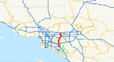
State Route 57 also known as the Orange Freeway, is a north–south state highway
in the Greater Los Angeles Area
of the U.S. state
of California
. It connects the interchange
of Interstate 5 and State Route 22
near downtown Orange
, locally known as the Orange Crush, with the Glendora Curve interchange with Interstate 210
and State Route 210 in Glendora
. The highway provides a route across several spurs of the Peninsular Ranges
, linking the Los Angeles Basin
with the Pomona Valley
and San Gabriel Valley
.
A predecessor to this road ran through Brea Canyon by the early 20th Century, and was added to the state highway system. The freeway was built in stages during the 1950s, one of which included the Brea Canyon Freeway. The portion of the Orange Freeway that remained unconstructed was not completed until the early 1970s. The latest piece of SR 57 to be added was formerly part of I-210, after SR 210 was extended to San Bernardino
. An unconstructed extension from Santa Ana south to Huntington Beach
remains in the legal definition of Route 57, and has been studied, most recently as a toll road
above the Santa Ana River
.
 SR 57 is eligible for the State Scenic Highway System
through Brea Canyon, between SR 90
and SR 60
, though it has not officially been designated by Caltrans as such. The entire route is in the California Freeway and Expressway System
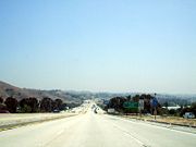
, and is a freeway where built.
SR 57 begins at the Orange Crush interchange
near downtown Orange
, where it meets the northwest-southeast Santa Ana Freeway
(Interstate 5) and the east–west Garden Grove Freeway (SR 22). The Orange Crush interchange, long considered a major bottleneck, was rebuilt in the 1990s and 2000s. The freeway heads north from the junction and soon crosses to the west side of the Santa Ana River
, continuing north through suburb
an portions of Anaheim
, passing next to Angel Stadium
and the Honda Center. In northern Anaheim, SR 57 meets the Riverside Freeway (SR 91
). SR 57 briefly passes through Placentia
and Fullerton
, providing access to California State University Fullerton. As it crosses Imperial Highway
(SR 90
) near the Brea Mall
and enters Brea
, SR 57 enters more rugged terrain, soon climbing through Brea Canyon, the gap between the Chino Hills
and Puente Hills
. Near its summit, the highway curves north out of the Brea Canyon, and descends slightly to a junction with the Pomona Freeway (SR 60
) in Diamond Bar
, right on the edge of the San Gabriel Valley
.
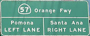
A short overlap carries SR 57 traffic on the outside of SR 60. The two routes head northeast through an arm of the San Gabriel Valley; after they split, SR 57 ascends slightly and then descends through the edge of the Puente Hills and into the west end of the Pomona Valley
. Here it meets the San Bernardino Freeway
(Interstate 10) and Chino Valley Freeway (SR 71
) at the four-level Kellogg Hill Interchange. In the north half of that interchange, SR 57 enters the San Jose Hills
, climbing to its highest elevation before descending back into the connected San Gabriel-Pomona Valleys and ending at the Glendora Curve interchange with the Foothill Freeway (Interstate 210
) in Glendora
.
High-occupancy vehicle (HOV) lanes exist in the median of SR 57 south of SR 60 in Diamond Bar. Elevated ramps allow HOV traffic bound to or from Brea Canyon to connect with Interstate 5 towards the southeast, SR 91 towards the west, or SR 60 towards the east without entering the main lanes.
 The road through Brea Canyon was oiled dirt by the late 1910s, providing a good connection across a spur of the Peninsular Ranges
between the Los Angeles Basin
and Pomona Valley. This road left the main coast highway (Harbor Boulevard
) at Fullerton
and followed the present Brea Boulevard and Brea Canyon Road, merging with the Valley Boulevard
from Los Angeles
near Walnut
and continuing east to Pomona
via Valley and Pomona Boulevards. Los Angeles County
paved the road in concrete
in early 1923, and in 1931 it was added to the state highway system as a branch of Route 19. Until then, Route 19 had connected Route 9 near Claremont
with Riverside
, following Garey Avenue and Mission Boulevard through Pomona.
The state built a bypass of the Valley Boulevard portion of the route in the early-to-mid 1930s, leaving the old road near Diamond Bar and heading northeast through the foothills, along the present freeway alignment and Mission Boulevard. To the south, the legislature added then-unrelated Route 180 along State College Boulevard in 1933, connecting Route 2 (Interstate 5) near the Santa Ana River with Route 175 (Orangethorpe Avenue, later replaced by SR 91) near Placentia. By 1955, the Brea Canyon Freeway was proposed to begin at the Santa Ana Freeway (I-5) near La Veta Avenue in Santa Ana and head north, paralleling Routes 180 and 19 to Pomona. (The portion northeast of Diamond Bar into Pomona soon became part of the planned Pomona Freeway, and the name of the remainder was changed to Orange Freeway.) The state legislature changed the definition of Route 19 to reflect this in 1957 by moving its south end to Santa Ana.
Also in 1957, the northernmost part of present SR 57 was added to the state highway system as part of Route 240, which the legislature designated along the route planned for Interstate 210. This became part of the proposed Temescal Freeway (later Corona Freeway); a southerly extension of the Orange Freeway to Legislative Route 60 (State Route 1
) near Huntington Beach
was added in 1959 as Route 273. Also in 1959, the legislature created Route 272, extending the line of the Orange Freeway north from the Pomona Freeway to the Temescal Freeway, completing the proposed freeway corridor that is now SR 57. At the time of the 1964 renumbering, when the entire route (except Route 240, which was still part of I-210) was redesignated Route 57, none of these proposed freeways had been built; the only constructed portion was the old surface road from Fullerton towards Pomona. (The portion of old Route 19 east of Route 272 became part of State Route 60
.) As part of the same renumbering, Route 180 on State College Boulevard became Route 250, which was amended the next year to provide for its deletion once that portion of the SR 57 freeway was completed (between Interstate 5 and State Route 91
).
 A groundbreaking ceremony was held in Placentia on January 30, 1967, to begin construction of the Orange Freeway. The first portion was dedicated on May 16, 1969 and opened soon after, extending north from the Riverside Freeway (State Route 91
) to Nutwood Avenue. Over the next few years, the freeway was completed from State Route 91 north to Interstate 10, and Interstate 210 was built north to the present end of SR 57; the Pomona Freeway (State Route 60
), which overlaps it through Diamond Bar
, was constructed at the same time. The last pieces of that portion were through Brea Canyon, opened March 13, 1972, and the four-level Kellogg Hill Interchange at I-10, dedicated May 1, 1972 and opened soon after. Finally, the Orange Freeway was extended south from State Route 91 to Interstate 5 in the mid-1970s, allowing Route 250 to be turned back to local governments (though the subsequent deletion from the Streets and Highways Code did not take place until 1981). With the extension of Route 210 around San Bernardino
in 1998, the former easternmost piece of Interstate 210 to the Kellogg Hill Interchange instead became a northerly extension of SR 57, though it remains officially part of the Interstate Highway System
.
(Interstate 405) in Costa Mesa
with connections to the Corona del Mar Freeway (State Route 73
). The extension was most recently considered as two 11.2-mile-long (18.0 km), two-lane viaduct
s, costing $950 million; the toll road franchise
expired in January 2001.
In April 2009, the Orange County Transportation Authority
continued to study the extension of SR 57, where the freeway would travel along the Santa Ana River and terminate at I-405 in Fountain Valley
.
{| class=wikitable
|-
!County
!Location
!Postmile
!Exit
!Destinations
!Notes
|-
|rowspan=17|Orange
ORA 10.83-R22.55
|rowspan=5|Orange
|10.83
|1A
|
|Southbound exit and northbound entrance; former US 101 south
|-
|10.83
|1
|
|Southbound exit and northbound entrance; signed as exits 1B (east) and 1C (west)
|- style="background:#fdd;"
|10.70
|1C
|La Veta Avenue
|Southbound exit and northbound entrance
|-
|11.24
|1D
|Chapman Avenue – Orange
|Signed as exit 1A northbound; former SR 51
|-
|11.80
|1E
|Orangewood Avenue
|Signed as exit 1B northbound
|-
|rowspan=4|Anaheim
|12.54
|2
|Katella Avenue
|
|-
|13.42
|3
|Ball Road
|
|-
|14.78
|4
|Lincoln Avenue – Anaheim
|Former US 91 / SR 18
|-
|15.60
|5
|
|Signed as exits 5A (east) and 5B (west)
|-
|Placentia
|16.39
|6A
|Orangethorpe Avenue
|Signed as exit 6 southbound; no northbound exit from SR 57 HOV lane interchange north; former SR 14
|-
|rowspan=4|Fullerton
|17.30
|6B
|Chapman Avenue – Fullerton
|Southbound exit is part of exit 7
|-
|17.57
|7
|Nutwood Avenue
|
|-
|18.34
|8
|Yorba Linda Boulevard
|
|-
|rowspan=2|19.86
|rowspan=2|9
|rowspan=2|
|rowspan=2|
|-
|rowspan=2|Brea
|-
|20.88
|10
|Lambert Road
|
|-
|
| style="background:#fdd;"|21.78
| style="background:#fdd;"|11
| style="background:#fdd;"|Tonner Canyon Road
| style="background:#fdd;"|Northbound exit and southbound entrance
|-
|rowspan=17|Los Angeles
LA R0.00-R12.21
|
| style="background:#fdd;"|R0.91
| style="background:#fdd;"|13
| style="background:#fdd;"|Brea Canyon Road
| style="background:#fdd;"|Southbound exit and northbound entrance; former SR 57
|-
|rowspan=2|Diamond Bar
|R1.94
|14
|Diamond Bar Boulevard
|
|-
|R3.17
|15
|Pathfinder Road
|
|-
|rowspan=2|Diamond Bar
,
Industry
| style="background:#dfd;"|R4.52
R23.56Indicates that the postmile represents the distance along SR 60
rather than SR 57.
| style="background:#dfd;"|16
| style="background:#dfd;"|
| style="background:#dfd;"|South end of SR 60 overlap; no exit number southbound
|-
|R24.45
|24B
|Grand Avenue – Diamond Bar
|
|-
|rowspan=2|Diamond Bar
| style="background:#dfd;"|R25.46
R4.52
| style="background:#dfd;"|
| style="background:#dfd;"|
| style="background:#dfd;"|North end of SR 60 overlap; southbound exit is via exit 18
|- style="background:#fdd;"
|4.98
|18
|Sunset Crossing Road
|No northbound exit
|-
|rowspan=2|Pomona
|6.17
|20
|Temple Avenue
|
|-
|rowspan=2|R7.72
|rowspan=2|21
|rowspan=2|
|rowspan=2|Signed as exits 22A (west) and 22B (east) southbound
|-
|rowspan=5|San Dimas
|- style="background:#fdd;"
|R7.94
|22C
|
|Southbound exit and northbound entrance
|-
|R8.71
|22D
|Via Verde, Raging Waters Drive
|Signed as exit 22 northbound
|-
|R10.27
|24A
|Covina Boulevard
|
|-
|R10.79
|24B
|Arrow Highway – San Dimas
|
|-
|rowspan=3|Glendora
| style="background:#fdd;"|R11.57
| style="background:#fdd;"|25A
| style="background:#fdd;"|Auto Centre Drive
| style="background:#fdd;"|Northbound exit and southbound entrance
|-
|R12.21
|25B
|
|Northbound exit and southbound entrance; former SR 30
|-
|R12.30
|
|
|Northbound exit and southbound entrance
State highway
State highway, state road or state route can refer to one of three related concepts, two of them related to a state or provincial government in a country that is divided into states or provinces :#A...
in the Greater Los Angeles Area
Greater Los Angeles Area
The Greater Los Angeles Area, or the Southland, is a term used for the Combined Statistical Area sprawled over five counties in the southern part of California, namely Los Angeles County, Orange County, San Bernardino County, Riverside County and Ventura County...
of the U.S. state
U.S. state
A U.S. state is any one of the 50 federated states of the United States of America that share sovereignty with the federal government. Because of this shared sovereignty, an American is a citizen both of the federal entity and of his or her state of domicile. Four states use the official title of...
of California
California
California is a state located on the West Coast of the United States. It is by far the most populous U.S. state, and the third-largest by land area...
. It connects the interchange
Interchange (road)
In the field of road transport, an interchange is a road junction that typically uses grade separation, and one or more ramps, to permit traffic on at least one highway to pass through the junction without directly crossing any other traffic stream. It differs from a standard intersection, at which...
of Interstate 5 and State Route 22
California State Route 22
State Route 22 in the U.S. state of California is an east–west highway in southern Los Angeles County and northern Orange County. It runs between Long Beach and Orange by way of Garden Grove. The westernmost part of it is a surface street, Long Beach's 7th Street. From Long Beach to its...
near downtown Orange
Orange, California
Southern California is well-known for year-round pleasant weather: - On average, the warmest month is August. - The highest recorded temperature was in 1985. - On average, the coolest month is December. - The lowest recorded temperature was in 1950...
, locally known as the Orange Crush, with the Glendora Curve interchange with Interstate 210
Interstate 210 (California)
Interstate 210 and State Route 210 together form a contiguous highway, called the Foothill Freeway, in the Greater Los Angeles area of the U.S. state of California. The western portion of the route is an auxiliary Interstate Highway, while the eastern portion is a state highway...
and State Route 210 in Glendora
Glendora, California
Glendora is a municipality in Los Angeles County, California, United States, east of downtown Los Angeles. As of the 2010 census, the population of Glendora was 50,073....
. The highway provides a route across several spurs of the Peninsular Ranges
Peninsular Ranges
The Peninsular Ranges are a group of mountain ranges, in the Pacific Coast Ranges, which stretch from southern California in the United States to the southern tip of Mexico's Baja California peninsula; they are part of the North American Coast Ranges that run along the Pacific coast from Alaska...
, linking the Los Angeles Basin
Los Angeles Basin
The Los Angeles Basin is the coastal sediment-filled plain located between the Peninsular and Transverse ranges in southern California in the United States containing the central part of the city of Los Angeles as well as its southern and southeastern suburbs...
with the Pomona Valley
Pomona Valley
The Pomona Valley, located between the San Gabriel Valley and Cucamonga Valley in Southern California, straddles the border between Los Angeles County and San Bernardino County. Back on March 1, 1893 the California Assembly voted 54-14 for a new county to form in the region, San Antonio County,...
and San Gabriel Valley
San Gabriel Valley
The San Gabriel Valley is one of the principal valleys of Southern California, United States. It lies to the east of Los Angeles, to the north of the Puente Hills, to the south of the San Gabriel Mountains, and west of the Inland Empire. It derives its name from the San Gabriel River that flows...
.
A predecessor to this road ran through Brea Canyon by the early 20th Century, and was added to the state highway system. The freeway was built in stages during the 1950s, one of which included the Brea Canyon Freeway. The portion of the Orange Freeway that remained unconstructed was not completed until the early 1970s. The latest piece of SR 57 to be added was formerly part of I-210, after SR 210 was extended to San Bernardino
San Bernardino, California
San Bernardino is a city located in the Riverside-San Bernardino metropolitan area , and serves as the county seat of San Bernardino County, California, United States...
. An unconstructed extension from Santa Ana south to Huntington Beach
Huntington Beach, California
Huntington Beach is a seaside city in Orange County in Southern California. According to the 2010 census, the city population was 189,992; making it the largest beach city in Orange County in terms of population...
remains in the legal definition of Route 57, and has been studied, most recently as a toll road
Toll road
A toll road is a privately or publicly built road for which a driver pays a toll for use. Structures for which tolls are charged include toll bridges and toll tunnels. Non-toll roads are financed using other sources of revenue, most typically fuel tax or general tax funds...
above the Santa Ana River
Santa Ana River
The Santa Ana River is the largest river of Southern California in the United States. Its drainage basin spans four counties. It rises in the San Bernardino Mountains and flows past the cities of San Bernardino and Riverside, before cutting through the northern tip of the Santa Ana Mountains and...
.
Route description
State Scenic Highway System (California)
The State Scenic Highway System is a list of highways, mainly state highways, that have been designated by the California Department of Transportation as scenic highways. The California State Legislature, primarily through Section 263 of the Streets and Highways Code, makes highways eligible for...
through Brea Canyon, between SR 90
California State Route 90
State Route 90 is a state highway in Southern California, United States. It consists of two unconnected pieces in Greater Los Angeles....
and SR 60
California State Route 60
State Route 60 is a state highway in the U.S. state of California. It runs from Interstate 10 near the Los Angeles River in Los Angeles east to I-10 in Riverside County, with overlaps at State Route 57 and Interstate 215.-Route description:...
, though it has not officially been designated by Caltrans as such. The entire route is in the California Freeway and Expressway System
California Freeway and Expressway System
The California Freeway and Expressway System is a system of existing or planned freeways and expressways in the U.S. state of California. It is defined by the Streets and Highways Code.-List of roads in the system:*State Route 1 *State Route 2...
, and is a freeway where built.
SR 57 begins at the Orange Crush interchange
Orange Crush interchange
The Orange Crush Interchange is a freeway interchange in the city of Orange, California, near the confluence of the cities of Orange, Santa Ana, Anaheim, and Garden Grove. The Disneyland Resort, The Block at Orange, St...
near downtown Orange
Orange, California
Southern California is well-known for year-round pleasant weather: - On average, the warmest month is August. - The highest recorded temperature was in 1985. - On average, the coolest month is December. - The lowest recorded temperature was in 1950...
, where it meets the northwest-southeast Santa Ana Freeway
Santa Ana Freeway
The Santa Ana Freeway is one of the principal freeways in Southern California, connecting Los Angeles and its southeastern suburbs including the freeway's namesake, the city of Santa Ana. The freeway begins at the Four Level Interchange in downtown Los Angeles, signed as U.S. Route 101...
(Interstate 5) and the east–west Garden Grove Freeway (SR 22). The Orange Crush interchange, long considered a major bottleneck, was rebuilt in the 1990s and 2000s. The freeway heads north from the junction and soon crosses to the west side of the Santa Ana River
Santa Ana River
The Santa Ana River is the largest river of Southern California in the United States. Its drainage basin spans four counties. It rises in the San Bernardino Mountains and flows past the cities of San Bernardino and Riverside, before cutting through the northern tip of the Santa Ana Mountains and...
, continuing north through suburb
Suburb
The word suburb mostly refers to a residential area, either existing as part of a city or as a separate residential community within commuting distance of a city . Some suburbs have a degree of administrative autonomy, and most have lower population density than inner city neighborhoods...
an portions of Anaheim
Anaheim, California
Anaheim is a city in Orange County, California. As of the 2010 United States Census, the city population was about 365,463, making it the most populated city in Orange County, the 10th most-populated city in California, and ranked 54th in the United States...
, passing next to Angel Stadium
Angel Stadium of Anaheim
Angel Stadium of Anaheim is a modern-style ballpark located in Anaheim, California. It is the home ballpark to Major League Baseball's Los Angeles Angels of Anaheim of the American League, and was previously home to the NFL's Los Angeles Rams...
and the Honda Center. In northern Anaheim, SR 57 meets the Riverside Freeway (SR 91
California State Route 91
State Route 91 is a major east–west freeway located entirely within Southern California and serving several regions of the Greater Los Angeles metropolitan area...
). SR 57 briefly passes through Placentia
Placentia, California
-Local: Placentia is a Charter city with an elected city council and professional city manager. Placentia City Council*Mayor- Scott W. Nelson*Mayor Pro Tem- Jeremy Yamaguchi*Council Member- Joe Aquirre*Council Member- Constance Underhill...
and Fullerton
Fullerton, California
Fullerton is a city located in northern Orange County, California. As of the 2010 census, the city had a total population of 135,161.It was founded in 1887 by George and Edward Amerige and named for George H. Fullerton, who secured the land on behalf of the Atchison, Topeka and Santa Fe Railway...
, providing access to California State University Fullerton. As it crosses Imperial Highway
Imperial Highway
Imperial Highway is a road in Orange and Los Angeles counties in California. It begins at the Anaheim-Orange boundary and runs through several cities until it stops at Dockweiler State Beach in Los Angeles near the Los Angeles International Airport. For much of the way, Imperial Highway is signed...
(SR 90
California State Route 90
State Route 90 is a state highway in Southern California, United States. It consists of two unconnected pieces in Greater Los Angeles....
) near the Brea Mall
Brea Mall
The Brea Mall is a shopping mall located in the Orange County city of Brea, California. Since 1998 the mall has been owned and operated by the Simon Property Group. It is home to four major department stores, over 175 specialty shops and boutiques, and a food court. It is approximately 1,310,000...
and enters Brea
Brea, California
Brea is a city in Orange County, California. The population, as of the 2010 Census was 39,282.The city began as a center of crude oil production, was later propelled by citrus production, and is now an important retail center because of the large Brea Mall and the recently redeveloped Brea Downtown...
, SR 57 enters more rugged terrain, soon climbing through Brea Canyon, the gap between the Chino Hills
Chino Hills
The Chino Hills are a mountain range on the border of Orange, Los Angeles, and San Bernardino Counties, California, with a small portion in Riverside County...
and Puente Hills
Puente Hills
The Puente Hills is a chain of hills, one of the lower Transverse Ranges, in an unincorporated area in eastern Los Angeles County, California.-Geography:...
. Near its summit, the highway curves north out of the Brea Canyon, and descends slightly to a junction with the Pomona Freeway (SR 60
California State Route 60
State Route 60 is a state highway in the U.S. state of California. It runs from Interstate 10 near the Los Angeles River in Los Angeles east to I-10 in Riverside County, with overlaps at State Route 57 and Interstate 215.-Route description:...
) in Diamond Bar
Diamond Bar, California
Diamond Bar is a city in eastern Los Angeles County, California, United States. The population was 55,544 at the 2010 census, down from 56,287 at the 2000 census. It is named after the "diamond over a bar" branding iron registered in 1918 by ranch owner Frederick E...
, right on the edge of the San Gabriel Valley
San Gabriel Valley
The San Gabriel Valley is one of the principal valleys of Southern California, United States. It lies to the east of Los Angeles, to the north of the Puente Hills, to the south of the San Gabriel Mountains, and west of the Inland Empire. It derives its name from the San Gabriel River that flows...
.
A short overlap carries SR 57 traffic on the outside of SR 60. The two routes head northeast through an arm of the San Gabriel Valley; after they split, SR 57 ascends slightly and then descends through the edge of the Puente Hills and into the west end of the Pomona Valley
Pomona Valley
The Pomona Valley, located between the San Gabriel Valley and Cucamonga Valley in Southern California, straddles the border between Los Angeles County and San Bernardino County. Back on March 1, 1893 the California Assembly voted 54-14 for a new county to form in the region, San Antonio County,...
. Here it meets the San Bernardino Freeway
San Bernardino Freeway
The San Bernardino Freeway, formerly known as the Ramona Freeway is a freeway in Los Angeles and Orange Counties in the southern part of the U.S. state of California. It refers to the following two segments:...
(Interstate 10) and Chino Valley Freeway (SR 71
California State Route 71
State Route 71 is the Chino Valley Freeway, formerly the Corona Expressway and before then the Temescal Freeway, a freeway/highway of about 15 miles in length located entirely within Southern California, United States...
) at the four-level Kellogg Hill Interchange. In the north half of that interchange, SR 57 enters the San Jose Hills
San Jose Hills
The San Jose Hills are a part of the Transverse Ranges located in Eastern Los Angeles County, California, marking the border between the San Gabriel Valley and the Pomona Valley in the Inland Empire. It includes portions of Covina, West Covina, Walnut, Pomona, and San Dimas.- Geology :The San Jose...
, climbing to its highest elevation before descending back into the connected San Gabriel-Pomona Valleys and ending at the Glendora Curve interchange with the Foothill Freeway (Interstate 210
Interstate 210 (California)
Interstate 210 and State Route 210 together form a contiguous highway, called the Foothill Freeway, in the Greater Los Angeles area of the U.S. state of California. The western portion of the route is an auxiliary Interstate Highway, while the eastern portion is a state highway...
) in Glendora
Glendora, California
Glendora is a municipality in Los Angeles County, California, United States, east of downtown Los Angeles. As of the 2010 census, the population of Glendora was 50,073....
.
High-occupancy vehicle (HOV) lanes exist in the median of SR 57 south of SR 60 in Diamond Bar. Elevated ramps allow HOV traffic bound to or from Brea Canyon to connect with Interstate 5 towards the southeast, SR 91 towards the west, or SR 60 towards the east without entering the main lanes.
History
Peninsular Ranges
The Peninsular Ranges are a group of mountain ranges, in the Pacific Coast Ranges, which stretch from southern California in the United States to the southern tip of Mexico's Baja California peninsula; they are part of the North American Coast Ranges that run along the Pacific coast from Alaska...
between the Los Angeles Basin
Los Angeles Basin
The Los Angeles Basin is the coastal sediment-filled plain located between the Peninsular and Transverse ranges in southern California in the United States containing the central part of the city of Los Angeles as well as its southern and southeastern suburbs...
and Pomona Valley. This road left the main coast highway (Harbor Boulevard
Harbor Boulevard
Harbor Boulevard is a major thoroughfare in central Orange County.-Route description:It runs from Costa Mesa through Santa Ana, Garden Grove, Anaheim and La Habra before it turns into Fullerton Road in the unincorporated community of Rowland Heights just over the Los Angeles County line...
) at Fullerton
Fullerton, California
Fullerton is a city located in northern Orange County, California. As of the 2010 census, the city had a total population of 135,161.It was founded in 1887 by George and Edward Amerige and named for George H. Fullerton, who secured the land on behalf of the Atchison, Topeka and Santa Fe Railway...
and followed the present Brea Boulevard and Brea Canyon Road, merging with the Valley Boulevard
Valley Boulevard
Valley Boulevard is a street in Southern California, running east from Los Angeles to Pomona, where it becomes Holt Boulevard, and a continuation from Fontana to Colton. It generally parallels Interstate 10 and State Route 60, and is the original alignment of U.S. Route 60...
from Los Angeles
Los Angeles, California
Los Angeles , with a population at the 2010 United States Census of 3,792,621, is the most populous city in California, USA and the second most populous in the United States, after New York City. It has an area of , and is located in Southern California...
near Walnut
Walnut, California
Walnut is a city in Los Angeles County, California, United States. The population was 29,172 at the 2010 census and its current mayor is Tom King, a former Detective from the Los Angeles Police Department....
and continuing east to Pomona
Pomona, California
-2010:The 2010 United States Census reported that Pomona had a population of 149,058, a slight decline from the 2000 census population. The population density was 6,491.2 people per square mile...
via Valley and Pomona Boulevards. Los Angeles County
Los Angeles County, California
Los Angeles County is a county in the U.S. state of California. As of 2010 U.S. Census, the county had a population of 9,818,605, making it the most populous county in the United States. Los Angeles County alone is more populous than 42 individual U.S. states...
paved the road in concrete
Concrete
Concrete is a composite construction material, composed of cement and other cementitious materials such as fly ash and slag cement, aggregate , water and chemical admixtures.The word concrete comes from the Latin word...
in early 1923, and in 1931 it was added to the state highway system as a branch of Route 19. Until then, Route 19 had connected Route 9 near Claremont
Claremont, California
Claremont is a small affluent college town in eastern Los Angeles County, California, United States, about east of downtown Los Angeles at the base of the San Gabriel Mountains. The population as of the 2010 census is 34,926. Claremont is known for its seven higher-education institutions, its...
with Riverside
Riverside, California
Riverside is a city in Riverside County, California, United States, and the county seat of the eponymous county. Named for its location beside the Santa Ana River, it is the largest city in the Riverside-San Bernardino-Ontario metropolitan area of Southern California, 4th largest inland California...
, following Garey Avenue and Mission Boulevard through Pomona.
The state built a bypass of the Valley Boulevard portion of the route in the early-to-mid 1930s, leaving the old road near Diamond Bar and heading northeast through the foothills, along the present freeway alignment and Mission Boulevard. To the south, the legislature added then-unrelated Route 180 along State College Boulevard in 1933, connecting Route 2 (Interstate 5) near the Santa Ana River with Route 175 (Orangethorpe Avenue, later replaced by SR 91) near Placentia. By 1955, the Brea Canyon Freeway was proposed to begin at the Santa Ana Freeway (I-5) near La Veta Avenue in Santa Ana and head north, paralleling Routes 180 and 19 to Pomona. (The portion northeast of Diamond Bar into Pomona soon became part of the planned Pomona Freeway, and the name of the remainder was changed to Orange Freeway.) The state legislature changed the definition of Route 19 to reflect this in 1957 by moving its south end to Santa Ana.
Also in 1957, the northernmost part of present SR 57 was added to the state highway system as part of Route 240, which the legislature designated along the route planned for Interstate 210. This became part of the proposed Temescal Freeway (later Corona Freeway); a southerly extension of the Orange Freeway to Legislative Route 60 (State Route 1
California State Route 1
State Route 1 , more often called Highway 1, is a state highway that runs along much of the Pacific coast of the U.S. state of California. It is famous for running along some of the most beautiful coastlines in the world, leading to its designation as an All-American Road.Highway 1 does not run...
) near Huntington Beach
Huntington Beach, California
Huntington Beach is a seaside city in Orange County in Southern California. According to the 2010 census, the city population was 189,992; making it the largest beach city in Orange County in terms of population...
was added in 1959 as Route 273. Also in 1959, the legislature created Route 272, extending the line of the Orange Freeway north from the Pomona Freeway to the Temescal Freeway, completing the proposed freeway corridor that is now SR 57. At the time of the 1964 renumbering, when the entire route (except Route 240, which was still part of I-210) was redesignated Route 57, none of these proposed freeways had been built; the only constructed portion was the old surface road from Fullerton towards Pomona. (The portion of old Route 19 east of Route 272 became part of State Route 60
California State Route 60
State Route 60 is a state highway in the U.S. state of California. It runs from Interstate 10 near the Los Angeles River in Los Angeles east to I-10 in Riverside County, with overlaps at State Route 57 and Interstate 215.-Route description:...
.) As part of the same renumbering, Route 180 on State College Boulevard became Route 250, which was amended the next year to provide for its deletion once that portion of the SR 57 freeway was completed (between Interstate 5 and State Route 91
California State Route 91
State Route 91 is a major east–west freeway located entirely within Southern California and serving several regions of the Greater Los Angeles metropolitan area...
).
California State Route 91
State Route 91 is a major east–west freeway located entirely within Southern California and serving several regions of the Greater Los Angeles metropolitan area...
) to Nutwood Avenue. Over the next few years, the freeway was completed from State Route 91 north to Interstate 10, and Interstate 210 was built north to the present end of SR 57; the Pomona Freeway (State Route 60
California State Route 60
State Route 60 is a state highway in the U.S. state of California. It runs from Interstate 10 near the Los Angeles River in Los Angeles east to I-10 in Riverside County, with overlaps at State Route 57 and Interstate 215.-Route description:...
), which overlaps it through Diamond Bar
Diamond Bar, California
Diamond Bar is a city in eastern Los Angeles County, California, United States. The population was 55,544 at the 2010 census, down from 56,287 at the 2000 census. It is named after the "diamond over a bar" branding iron registered in 1918 by ranch owner Frederick E...
, was constructed at the same time. The last pieces of that portion were through Brea Canyon, opened March 13, 1972, and the four-level Kellogg Hill Interchange at I-10, dedicated May 1, 1972 and opened soon after. Finally, the Orange Freeway was extended south from State Route 91 to Interstate 5 in the mid-1970s, allowing Route 250 to be turned back to local governments (though the subsequent deletion from the Streets and Highways Code did not take place until 1981). With the extension of Route 210 around San Bernardino
San Bernardino, California
San Bernardino is a city located in the Riverside-San Bernardino metropolitan area , and serves as the county seat of San Bernardino County, California, United States...
in 1998, the former easternmost piece of Interstate 210 to the Kellogg Hill Interchange instead became a northerly extension of SR 57, though it remains officially part of the Interstate Highway System
Interstate Highway System
The Dwight D. Eisenhower National System of Interstate and Defense Highways, , is a network of limited-access roads including freeways, highways, and expressways forming part of the National Highway System of the United States of America...
.
Future
The southerly extension to Huntington Beach remains unconstructed. The most recent plans were for a toll road elevated above the Santa Ana River rather than through existing neighborhoods, only extending south to the San Diego FreewayInterstate 405 (California)
Interstate 405 is a major north–south Interstate Highway in Southern California. It is a bypass of Interstate 5, running along the western areas of the Greater Los Angeles Area from Irvine in the south to near San Fernando in the north...
(Interstate 405) in Costa Mesa
Costa Mesa, California
Costa Mesa is a city in Orange County, California. The population was 109,960 at the 2010 census. Since its incorporation in 1953, the city has grown from a semi-rural farming community of 16,840 to a primarily suburban and "edge" city with an economy based on retail, commerce, and light...
with connections to the Corona del Mar Freeway (State Route 73
California State Route 73
State Route 73 is a state highway in the U.S. state of California. The route runs from Interstate 405 to Interstate 5 through the San Joaquin Hills in Orange County. From its northern terminus, the first three miles of the highway are called the Corona del Mar Freeway; this section of highway...
). The extension was most recently considered as two 11.2-mile-long (18.0 km), two-lane viaduct
Viaduct
A viaduct is a bridge composed of several small spans. The term viaduct is derived from the Latin via for road and ducere to lead something. However, the Ancient Romans did not use that term per se; it is a modern derivation from an analogy with aqueduct. Like the Roman aqueducts, many early...
s, costing $950 million; the toll road franchise
Government-granted monopoly
In economics, a government-granted monopoly is a form of coercive monopoly by which a government grants exclusive privilege to a private individual or firm to be the sole provider of a good or service; potential competitors are excluded from the market by law, regulation, or other mechanisms of...
expired in January 2001.
In April 2009, the Orange County Transportation Authority
Orange County Transportation Authority
The Orange County Transportation Authority is the public sector transportation planning body and mass transit service provider for Orange County, California. Its ancestor agencies include not only the prior Orange County Transit District but also such diverse entities as the Pacific Electric...
continued to study the extension of SR 57, where the freeway would travel along the Santa Ana River and terminate at I-405 in Fountain Valley
Fountain Valley, California
Fountain Valley is a city in Orange County, California. The population was 55,313 at the 2010 census. A classic bedroom community, Fountain Valley is a middle-class residential area.- History :...
.
Exit list
- Note: Except where prefixed with a letter, postmiles were measured in 1964, based on the alignment as it existed at that time, and do not necessarily reflect current mileage. The numbers reset at county lines; the start and end postmiles in each county are given in the county column.
{| class=wikitable
|-
!County
!Location
!Postmile
!Exit
Exit number
An exit number is a number assigned to a road junction, usually an exit from a freeway. It is usually marked on the same sign as the destinations of the exit, as well as a sign in the gore....
!Destinations
!Notes
|-
|rowspan=17|Orange
Orange County, California
Orange County is a county in the U.S. state of California. Its county seat is Santa Ana. As of the 2010 census, its population was 3,010,232, up from 2,846,293 at the 2000 census, making it the third most populous county in California, behind Los Angeles County and San Diego County...
ORA 10.83-R22.55
|rowspan=5|Orange
Orange, California
Southern California is well-known for year-round pleasant weather: - On average, the warmest month is August. - The highest recorded temperature was in 1985. - On average, the coolest month is December. - The lowest recorded temperature was in 1950...
|10.83
|1A
|
|Southbound exit and northbound entrance; former US 101 south
|-
|10.83
|1
|
|Southbound exit and northbound entrance; signed as exits 1B (east) and 1C (west)
|- style="background:#fdd;"
|10.70
|1C
|La Veta Avenue
|Southbound exit and northbound entrance
|-
|11.24
|1D
|Chapman Avenue – Orange
|Signed as exit 1A northbound; former SR 51
|-
|11.80
|1E
|Orangewood Avenue
|Signed as exit 1B northbound
|-
|rowspan=4|Anaheim
Anaheim, California
Anaheim is a city in Orange County, California. As of the 2010 United States Census, the city population was about 365,463, making it the most populated city in Orange County, the 10th most-populated city in California, and ranked 54th in the United States...
|12.54
|2
|Katella Avenue
|
|-
|13.42
|3
|Ball Road
|
|-
|14.78
|4
|Lincoln Avenue – Anaheim
Anaheim, California
Anaheim is a city in Orange County, California. As of the 2010 United States Census, the city population was about 365,463, making it the most populated city in Orange County, the 10th most-populated city in California, and ranked 54th in the United States...
|Former US 91 / SR 18
|-
|15.60
|5
|
|Signed as exits 5A (east) and 5B (west)
|-
|Placentia
Placentia, California
-Local: Placentia is a Charter city with an elected city council and professional city manager. Placentia City Council*Mayor- Scott W. Nelson*Mayor Pro Tem- Jeremy Yamaguchi*Council Member- Joe Aquirre*Council Member- Constance Underhill...
|16.39
|6A
|Orangethorpe Avenue
|Signed as exit 6 southbound; no northbound exit from SR 57 HOV lane interchange north; former SR 14
|-
|rowspan=4|Fullerton
Fullerton, California
Fullerton is a city located in northern Orange County, California. As of the 2010 census, the city had a total population of 135,161.It was founded in 1887 by George and Edward Amerige and named for George H. Fullerton, who secured the land on behalf of the Atchison, Topeka and Santa Fe Railway...
|17.30
|6B
|Chapman Avenue – Fullerton
|Southbound exit is part of exit 7
|-
|17.57
|7
|Nutwood Avenue
|
|-
|18.34
|8
|Yorba Linda Boulevard
|
|-
|rowspan=2|19.86
|rowspan=2|9
|rowspan=2|
|rowspan=2|
|-
|rowspan=2|Brea
Brea, California
Brea is a city in Orange County, California. The population, as of the 2010 Census was 39,282.The city began as a center of crude oil production, was later propelled by citrus production, and is now an important retail center because of the large Brea Mall and the recently redeveloped Brea Downtown...
|-
|20.88
|10
|Lambert Road
|
|-
|
| style="background:#fdd;"|21.78
| style="background:#fdd;"|11
| style="background:#fdd;"|Tonner Canyon Road
| style="background:#fdd;"|Northbound exit and southbound entrance
|-
|rowspan=17|Los Angeles
Los Angeles County, California
Los Angeles County is a county in the U.S. state of California. As of 2010 U.S. Census, the county had a population of 9,818,605, making it the most populous county in the United States. Los Angeles County alone is more populous than 42 individual U.S. states...
LA R0.00-R12.21
|
| style="background:#fdd;"|R0.91
| style="background:#fdd;"|13
| style="background:#fdd;"|Brea Canyon Road
| style="background:#fdd;"|Southbound exit and northbound entrance; former SR 57
|-
|rowspan=2|Diamond Bar
Diamond Bar, California
Diamond Bar is a city in eastern Los Angeles County, California, United States. The population was 55,544 at the 2010 census, down from 56,287 at the 2000 census. It is named after the "diamond over a bar" branding iron registered in 1918 by ranch owner Frederick E...
|R1.94
|14
|Diamond Bar Boulevard
|
|-
|R3.17
|15
|Pathfinder Road
|
|-
|rowspan=2|Diamond Bar
Diamond Bar, California
Diamond Bar is a city in eastern Los Angeles County, California, United States. The population was 55,544 at the 2010 census, down from 56,287 at the 2000 census. It is named after the "diamond over a bar" branding iron registered in 1918 by ranch owner Frederick E...
,
Industry
Industry, California
Industry is an industrial suburb of Los Angeles in the San Gabriel Valley region of Los Angeles County. Home to over 2,500 businesses and 80,000 jobs, but only 219 residents at the 2010 census - down from 777 residents as of the 2000 United States census - the city is almost entirely industrial...
| style="background:#dfd;"|R4.52
R23.56Indicates that the postmile represents the distance along SR 60
California State Route 60
State Route 60 is a state highway in the U.S. state of California. It runs from Interstate 10 near the Los Angeles River in Los Angeles east to I-10 in Riverside County, with overlaps at State Route 57 and Interstate 215.-Route description:...
rather than SR 57.
| style="background:#dfd;"|16
| style="background:#dfd;"|
| style="background:#dfd;"|South end of SR 60 overlap; no exit number southbound
|-
|R24.45
|24B
|Grand Avenue – Diamond Bar
Diamond Bar, California
Diamond Bar is a city in eastern Los Angeles County, California, United States. The population was 55,544 at the 2010 census, down from 56,287 at the 2000 census. It is named after the "diamond over a bar" branding iron registered in 1918 by ranch owner Frederick E...
|
|-
|rowspan=2|Diamond Bar
Diamond Bar, California
Diamond Bar is a city in eastern Los Angeles County, California, United States. The population was 55,544 at the 2010 census, down from 56,287 at the 2000 census. It is named after the "diamond over a bar" branding iron registered in 1918 by ranch owner Frederick E...
| style="background:#dfd;"|R25.46
R4.52
| style="background:#dfd;"|
| style="background:#dfd;"|
| style="background:#dfd;"|North end of SR 60 overlap; southbound exit is via exit 18
|- style="background:#fdd;"
|4.98
|18
|Sunset Crossing Road
|No northbound exit
|-
|rowspan=2|Pomona
Pomona, California
-2010:The 2010 United States Census reported that Pomona had a population of 149,058, a slight decline from the 2000 census population. The population density was 6,491.2 people per square mile...
|6.17
|20
|Temple Avenue
|
|-
|rowspan=2|R7.72
|rowspan=2|21
|rowspan=2|
|rowspan=2|Signed as exits 22A (west) and 22B (east) southbound
|-
|rowspan=5|San Dimas
San Dimas, California
San Dimas is a city located in the San Gabriel Valley, in Los Angeles County, California. As of the 2010 census, the city had a total population of 33,371. The city historically took its name from San Dismas Canyon in the San Gabriel Mountains above the northern section of present day San Dimas...
|- style="background:#fdd;"
|R7.94
|22C
|
|Southbound exit and northbound entrance
|-
|R8.71
|22D
|Via Verde, Raging Waters Drive
|Signed as exit 22 northbound
|-
|R10.27
|24A
|Covina Boulevard
|
|-
|R10.79
|24B
|Arrow Highway – San Dimas
|
|-
|rowspan=3|Glendora
Glendora, California
Glendora is a municipality in Los Angeles County, California, United States, east of downtown Los Angeles. As of the 2010 census, the population of Glendora was 50,073....
| style="background:#fdd;"|R11.57
| style="background:#fdd;"|25A
| style="background:#fdd;"|Auto Centre Drive
| style="background:#fdd;"|Northbound exit and southbound entrance
|-
|R12.21
|25B
|
|Northbound exit and southbound entrance; former SR 30
|-
|R12.30
|
|
|Northbound exit and southbound entrance