

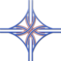
Stack interchange
Encyclopedia
Interchange (road)
In the field of road transport, an interchange is a road junction that typically uses grade separation, and one or more ramps, to permit traffic on at least one highway to pass through the junction without directly crossing any other traffic stream. It differs from a standard intersection, at which...
between two roads.
In countries where one drives on the right, left turns are handled by semi-directional flyover/under ramps. Vehicles first exit the main carriageway to the right, then complete the turn via a ramp which crosses both highways, eventually merging with the traffic turning right from the opposite side of the interchange. A stack interchange, then, has two pairs of left-turning ramps, which can be "stacked" in various configurations above or below the two interchanging highways.
In countries where one drives on the left, the appearance of the junction is topologically identical, but traffic flows are reversed.
Stacks eliminate the problems of weaving and have the highest vehicle capacity among different types of four-way interchanges. However, they require considerable and expensive construction work for their flyover ramps. Stack interchanges are also widely considered to be an eyesore among residents of homes near existing or proposed interchanges, leading to considerable NIMBY
NIMBY
NIMBY or Nimby is an acronym for the phrase "not in my back yard". The term is used pejoratively to describe opposition by residents to a proposal for a new development close to them. Opposing residents themselves are sometimes called Nimbies...
opposition.
Four-level stack
North America
The first stack interchange was the Four Level Interchange (renamed the Bill Keene Memorial Interchange), built in Los Angeles, CaliforniaLos Angeles, California
Los Angeles , with a population at the 2010 United States Census of 3,792,621, is the most populous city in California, USA and the second most populous in the United States, after New York City. It has an area of , and is located in Southern California...
and completed in 1949, at the junction of U.S. Route 101 and State Route 110. Since then, Caltrans has built eight more four-level stacks throughout the state of California
California
California is a state located on the West Coast of the United States. It is by far the most populous U.S. state, and the third-largest by land area...
, as well as a larger number of three-level stack/cloverleaf
Cloverleaf interchange
A cloverleaf interchange is a two-level interchange in which left turns, reverse direction in left-driving regions, are handled by ramp roads...
hybrids (where the least-used left-turning ramp is built as a cloverleaf-like 270-degree loop to save money).
One of the first four-level stack interchanges in the northeastern U.S. was constructed in the late 1960s over Interstate 84
Interstate 84 in Connecticut
Interstate 84 is an East–West Interstate highway across the state of Connecticut into Danbury, Waterbury, Hartford and Union.-Route description:...
in Farmington, Connecticut
Farmington, Connecticut
Farmington is a town located in Hartford County in the Farmington Valley area of central Connecticut in the United States. The population was 25,340 at the 2010 census. It is home to the world headquarters of several large corporations including Carrier Corporation, Otis Elevator Company, and Carvel...
, for the controversial Interstate 291
Interstate 291 (Connecticut)
Interstate 291 is a short Interstate Highway in the state of Connecticut that starts at I-91 at its junction with Route 218 in Windsor and ends at I-84 in Manchester. It serves as a northeastern bypass of Hartford...
beltway around the city of Hartford
Hartford, Connecticut
Hartford is the capital of the U.S. state of Connecticut. The seat of Hartford County until Connecticut disbanded county government in 1960, it is the second most populous city on New England's largest river, the Connecticut River. As of the 2010 Census, Hartford's population was 124,775, making...
. Most of the I-291
Interstate 291 (Connecticut)
Interstate 291 is a short Interstate Highway in the state of Connecticut that starts at I-91 at its junction with Route 218 in Windsor and ends at I-84 in Manchester. It serves as a northeastern bypass of Hartford...
beltway was later cancelled, and the sprawling stack lay dormant for almost twenty-five years. In 1992, the extension of Connecticut Route 9 to Interstate 84
Interstate 84 in Connecticut
Interstate 84 is an East–West Interstate highway across the state of Connecticut into Danbury, Waterbury, Hartford and Union.-Route description:...
utilized the I-291
Interstate 291 (Connecticut)
Interstate 291 is a short Interstate Highway in the state of Connecticut that starts at I-91 at its junction with Route 218 in Windsor and ends at I-84 in Manchester. It serves as a northeastern bypass of Hartford...
right-of-way and some sections of the abandoned interchange
Interchange (road)
In the field of road transport, an interchange is a road junction that typically uses grade separation, and one or more ramps, to permit traffic on at least one highway to pass through the junction without directly crossing any other traffic stream. It differs from a standard intersection, at which...
. Several ramps still remain unused, including abandoned roadbed for Interstate 291
Interstate 291 (Connecticut)
Interstate 291 is a short Interstate Highway in the state of Connecticut that starts at I-91 at its junction with Route 218 in Windsor and ends at I-84 in Manchester. It serves as a northeastern bypass of Hartford...
both north and south of the complex.
Four-level stacks are used for the interchange between Interstate 90
Interstate 90 in Washington
Interstate 90 , a transcontinental Interstate Highway from Seattle, Washington, to Boston, Massachusetts, crosses the state of Washington before crossing the Idaho state line between Spokane and Post Falls...
and Interstate 405
Interstate 405 (Washington)
Interstate 405 in Washington is a stretch of freeway that bypasses Seattle east of Lake Washington. The northern terminus is in Lynnwood and the southern terminus is in Tukwila...
in Bellevue, Washington
Bellevue, Washington
Bellevue is a city in the Eastside region of King County, Washington, United States, across Lake Washington from Seattle. Long known as a suburb or satellite city of Seattle, it is now categorized as an edge city or a boomburb. The population was 122,363 at the 2010 census.Downtown Bellevue is...
and for the interchange between I-110
Interstate 110 (Louisiana)
Interstate 110 is an spur route in Baton Rouge, running from Interstate 10 in the city's downtown area north to U.S. Highway 61 and the Baton Rouge Metropolitan Airport in the northern part of the city...
and US 61/US 190 in Louisiana.
Another well-known stack interchange lies west of Baltimore, Maryland, serving as the junction between Interstate 695
Interstate 695 (Maryland)
Interstate 695 is a -long full beltway Interstate Highway extending around Baltimore, Maryland, USA. I-695 is officially designated the McKeldin Beltway, but is colloquially referred to as either the Baltimore Beltway or 695...
and Interstate 70
Interstate 70 in Maryland
Interstate 70 is a part of the Interstate Highway System that runs from Cove Fort, Utah to Baltimore, Maryland. In Maryland, the Interstate Highway runs from the Pennsylvania state line in Hancock east to the Interstate's eastern terminus near its junction with I-695 at a park and ride in...
. It was originally built for a planned extension of I-70 into the city, but because of heavy opposition, I-70 now ends at a park and ride
Park and ride
Park and ride facilities are car parks with connections to public transport that allow commuters and other people wishing to travel into city centres to leave their vehicles and transfer to a bus, rail system , or carpool for the rest of their trip...
three miles east of here. As a result, the road east of I-695 sees very little traffic, compared to the high volumes to and from the west.
Though it planned to build many four-level stack interchanges, the Canadian
Canada
Canada is a North American country consisting of ten provinces and three territories. Located in the northern part of the continent, it extends from the Atlantic Ocean in the east to the Pacific Ocean in the west, and northward into the Arctic Ocean...
province of Ontario
Ontario
Ontario is a province of Canada, located in east-central Canada. It is Canada's most populous province and second largest in total area. It is home to the nation's most populous city, Toronto, and the nation's capital, Ottawa....
has only one true four-level stack interchange—the interchange between Highway 400 and Highway 407. Planned four-level stacks at Highway 407 and Highway 410, and Highway 407 and Highway 404 were reduced to three-level interchanges, with loop ramps in lieu of a fourth level of ramps. The interchange between Highway 401, 403, and 410 is almost a full four level stack, with a loop ramp planned to be added in the northeast quadrant.
Europe and elsewhere
In the United KingdomUnited Kingdom
The United Kingdom of Great Britain and Northern IrelandIn the United Kingdom and Dependencies, other languages have been officially recognised as legitimate autochthonous languages under the European Charter for Regional or Minority Languages...
there are three four-level stacks: at the junction of the M4
M4 motorway
The M4 motorway links London with South Wales. It is part of the unsigned European route E30. Other major places directly accessible from M4 junctions are Reading, Swindon, Bristol, Newport, Cardiff and Swansea...
and M25
M25 motorway
The M25 motorway, or London Orbital, is a orbital motorway that almost encircles Greater London, England, in the United Kingdom. The motorway was first mooted early in the 20th century. A few sections, based on the now abandoned London Ringways plan, were constructed in the early 1970s and it ...
near Heathrow Airport in London
London
London is the capital city of :England and the :United Kingdom, the largest metropolitan area in the United Kingdom, and the largest urban zone in the European Union by most measures. Located on the River Thames, London has been a major settlement for two millennia, its history going back to its...
, at the junction of the M23
M23 motorway
The M23 motorway is a motorway in England. The motorway runs from south of Hooley in Surrey, where it splits from the A23, to Pease Pottage, south of Crawley in West Sussex where it rejoins the A23. The northern end of the motorway starts at junction 7 on what is effectively a spur north from...
and M25
M25 motorway
The M25 motorway, or London Orbital, is a orbital motorway that almost encircles Greater London, England, in the United Kingdom. The motorway was first mooted early in the 20th century. A few sections, based on the now abandoned London Ringways plan, were constructed in the early 1970s and it ...
to the south of London, and at the junction of the M4
M4 motorway
The M4 motorway links London with South Wales. It is part of the unsigned European route E30. Other major places directly accessible from M4 junctions are Reading, Swindon, Bristol, Newport, Cardiff and Swansea...
and M5
M5 motorway
The M5 is a motorway in England. It runs from a junction with the M6 at West Bromwich near Birmingham to Exeter in Devon. Heading south-west, the M5 runs east of West Bromwich and west of Birmingham through Sandwell Valley...
near Bristol
Bristol
Bristol is a city, unitary authority area and ceremonial county in South West England, with an estimated population of 433,100 for the unitary authority in 2009, and a surrounding Larger Urban Zone with an estimated 1,070,000 residents in 2007...
(the Almondsbury Interchange
Almondsbury Interchange
The Almondsbury Interchange in South Gloucestershire, is one of the United Kingdom's largest motorway stack interchanges. The interchange is one of only three four-level stacks in the UK, spanning a range of 0.5 km by 0.5 km...
). The M4/M25 junction is particularly unusual as it also has a railway line bisecting it at its lowest level. The M4/M25 junction is slightly offset so there is no point where all four levels are directly above each other. M25 (north-south road in this junction) is offset to the east by approximately 60 metres (200 feet). The junction of the A19
A19 road
The A19 is a major road in England running approximately parallel to and east of the A1 road, although the two roads meet at the northern end of the A19, the two roads originally met at the southern end of the A19 in Doncaster but the old route of the A1 was changed to the A638. From Sunderland...
and A66
A66 road
The A66 is a major road in northern England which in part follows the course of the Roman road from Scotch Corner to Penrith. It runs from east of Middlesbrough in the ceremonial county of North Yorkshire to Workington in Cumbria...
in Teesside
Teesside
Teesside is the name given to the conurbation in the north east of England made up of the towns of Middlesbrough, Stockton-on-Tees, Redcar, Billingham and surrounding settlements near the River Tees. It was also the name of a local government district between 1968 and 1974—the County Borough of...
uses a three-level variant, with a 270-degree loop allowing southbound A19 traffic to exit to the westbound A66.
The Lighthorse Interchange at the junction of the M4
M4 Western Motorway
The M4 Western Motorway,, is a motorway in central Sydney, New South Wales, Australia...
and M7
Westlink M7
Westlink M7 - formerly Western Sydney Orbital - is one of Sydney, Australia's urban motorways and a part of Metroad 7 and the Sydney Orbital Network. It connects three Metroads: M5 at Prestons, M4 at Eastern Creek and M2 at Baulkham Hills...
, is an example of a four-level stack interchange in Sydney, New South Wales
New South Wales
New South Wales is a state of :Australia, located in the east of the country. It is bordered by Queensland, Victoria and South Australia to the north, south and west respectively. To the east, the state is bordered by the Tasman Sea, which forms part of the Pacific Ocean. New South Wales...
, Australia
Australia
Australia , officially the Commonwealth of Australia, is a country in the Southern Hemisphere comprising the mainland of the Australian continent, the island of Tasmania, and numerous smaller islands in the Indian and Pacific Oceans. It is the world's sixth-largest country by total area...
.
The EB Cloete Interchange just outside of Durban, South Africa is another example of a four-level stack interchange. The N3 is the busiest highway in South Africa and is a very busy truck route. Since Johannesburg
Johannesburg
Johannesburg also known as Jozi, Jo'burg or Egoli, is the largest city in South Africa, by population. Johannesburg is the provincial capital of Gauteng, the wealthiest province in South Africa, having the largest economy of any metropolitan region in Sub-Saharan Africa...
is not located near a body of water, most of the city's exports travel through the Port of Durban. The N2 connects Cape Town
Cape Town
Cape Town is the second-most populous city in South Africa, and the provincial capital and primate city of the Western Cape. As the seat of the National Parliament, it is also the legislative capital of the country. It forms part of the City of Cape Town metropolitan municipality...
with Durban
Durban
Durban is the largest city in the South African province of KwaZulu-Natal and the third largest city in South Africa. It forms part of the eThekwini metropolitan municipality. Durban is famous for being the busiest port in South Africa. It is also seen as one of the major centres of tourism...
, and it serves the South African cities of Port Elizabeth, Plettenberg Bay
Plettenberg Bay
Plettenberg Bay, nicknamed Plet or Plett, is the primary town of the Bitou Local Municipality in the Western Cape Province of South Africa. As of the census of 2001, there were 29149 population...
, Margate
Margate, KwaZulu-Natal
Margate is a seaside resort town on the KwaZulu-Natal South Coast, just about 20 kilometres southwest of Port Shepstone. The river which flows into the sea at Margate is called "Nkhongweni" because the original inhabitants were reputed to be so mean that travellers had to beg for hospitality...
, and Greater St. Lucia Wetland Park. Two busy roads intersect at the junction. A four-level stack interchange was chosen to serve the high volumes of traffic.
Texas-style stack
Stacks are often five levels in Texas. They have the same configuration as four-level stacks, with frontage roadFrontage road
A frontage road is a non-limited access road running parallel to a higher-speed road, usually a freeway, and feeding it at appropriate points of access...
s adding a fifth level. The frontage road
Frontage road
A frontage road is a non-limited access road running parallel to a higher-speed road, usually a freeway, and feeding it at appropriate points of access...
s usually intersect with traffic lights, and are similar to a grid of nearby one-way streets. A common setup is for one mainline to go below grade and another mainline to go above grade. The intersection of the frontage roads is typically at-grade (or close to it). Then two pairs of "left turn" connectors are built above these.
The Houston, Texas
Houston, Texas
Houston is the fourth-largest city in the United States, and the largest city in the state of Texas. According to the 2010 U.S. Census, the city had a population of 2.1 million people within an area of . Houston is the seat of Harris County and the economic center of , which is the ...
, area has 7 five-level stack interchanges along Beltway 8: at Interstate 10
Interstate 10 in Texas
Interstate 10 is the major east–west Interstate Highway in the Southern United States. In the U.S. state of Texas, it runs east from El Paso, near the border with New Mexico, through San Antonio and Houston to the border with Louisiana in Orange, Texas....
east and west of downtown, U.S. Highway 59
U.S. Route 59 in Texas
In the U.S. state of Texas, U.S. 59 is named the Lloyd Bentsen Highway, after Lloyd Bentsen, former U.S. Senator from Texas. In northern Houston, US 59 is the Eastex Freeway...
northeast and southwest of downtown, Interstate 45
Interstate 45
Interstate 45 is an intrastate Interstate Highway located entirely within the U.S. state of Texas. It connects the cities of Dallas and Houston, continuing southeast from Houston to Galveston over the Galveston Causeway to the Gulf of Mexico...
north and south of downtown, and U.S. Highway 290
U.S. Route 290
U.S. Highway 290 is an east–west U.S. Highway located entirely within the State of Texas. Its current western terminus is at Interstate 10 milepost 477 , southeast of Junction, and its eastern terminus is at Interstate 610 on the northwest side of Houston.-Route Description:West of Austin, U.S...
in the beltway's northwest quadrant. The newly-reconstructed interchange of Interstate 610
Interstate 610 (Texas)
Interstate 610 is a freeway that forms a forty-two-mile loop around the downtown sector of city of Houston, Texas. Interstate 610, colloquially known as "The Loop", "Loop 610", "The 610 Loop", or just "610", traditionally marks the border between the inner city of Houston and its surrounding areas...
and U.S. 59
U.S. Route 59
U.S. Route 59 is a north–south United States highway . A latecomer to the U.S. numbered route system, U.S. 59 is now a border-to-border route, Part of NAFTA Corridor Highway System. It parallels U.S. Route 75 for nearly its entire route, never much more than away, until it veers southwest...
, with the new I-610 northbound feeder road built underground and the new I-610 southbound feeder road overpass, is also a five-level stack interchange. In Dallas, the award-winning High Five Interchange
High Five Interchange
thumb|High Five interchange.The High Five Interchange is a five-level freeway interchange, designed by the HNTB Corporation, that connects Lyndon B. Johnson Freeway and Central Expressway in Dallas, Texas, United States...
was completed in 2005 and features some ramps which are more than 12 stories
Storey
A storey or story is any level part of a building that could be used by people...
above the ground.
Though not a "Texas-style stack" in the above sense, an unusual stack is nonetheless found in Houston which features more than four levels of traffic, but whose fifth level exists in only one direction. In 2011, the previously 4-level stack interchange between I-610 and I-10 on the city's east side gained a new (though long-planned) level of complexity with the opening of four ramps connecting the new US 90 Crosby Freeway to the east, featuring direct movements for the new freeway to and from the southeast quadrant of I-610, to westbound I-10, and from eastbound I-10. It is the latter ramp which gives the interchange the fifth level, as US 90 to I-10 West merges onto I-10 before crossing I-610. (None of the frontage roads for these highways cross the interchange itself, and thus do not factor in the complexity of the stack.)
Other five-level stacks
High-occupancy vehicle lane
In transportation engineering and transportation planning, a high-occupancy vehicle lane is a lane reserved for vehicles with a driver and one or more passengers...
connectors. An example of this exists in Los Angeles, California
Los Angeles, California
Los Angeles , with a population at the 2010 United States Census of 3,792,621, is the most populous city in California, USA and the second most populous in the United States, after New York City. It has an area of , and is located in Southern California...
at the Judge Harry Pregerson Interchange
Judge Harry Pregerson Interchange
The Judge Harry Pregerson Interchange is a stack interchange near the Athens and Watts communities of Los Angeles, California. It is the interchange of the following routes:...
. The connector from HOV SB 110 to HOV WB 105 can be at the same level as the connector from mixed EB 105 to mixed NB 110, but the connector from HOV SB 110 to HOV EB 105 needs to be higher level, since it crosses over the latter connector.
Another case is where connection to nearby arterials suggests that another level may be useful, thus
making the interchange more complicated, but easier to use. In the Atlanta area, a side ramp forms the fifth level of the Tom Moreland Interchange
Tom Moreland Interchange
Tom Moreland Interchange, colloquially known as Spaghetti Junction, is the intersection of Interstate 85 and Interstate 285, along with several access roads, in northern DeKalb County, Georgia, just northeast of Atlanta, Georgia, USA...
found in DeKalb County, Georgia
DeKalb County, Georgia
DeKalb County is a county located in the U.S. state of Georgia. The population of the county was 691,893 at the 2010 census. Its county seat is the city of Decatur. It is bordered to the west by Fulton County and contains roughly 10% of the city of Atlanta...
.
External links
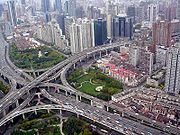
- Satellite image of Nanbei Elevated Road and Yanan Elevated Road 6-level interchange in Shanghai, China.
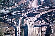
- Satellite image of Interstate 105 and Interstate 110 5-level interchange in Los Angeles, CA.
- Satellite image of Interstate 95 and Interstate 695 4-level interchange near Baltimore, MD.