
California State Route 71
Encyclopedia
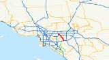
State Route 71 is the Chino Valley Freeway, formerly the Corona Expressway and before then the Temescal Freeway, a freeway/highway of about 15 miles (24 km) in length located entirely within Southern California
, United States
. Contrary to its name, this highway is only a freeway in San Bernardino
and Riverside counties
; in Los Angeles County
it is only an expressway
.
and is eligible for the State Scenic Highway System
. However, it is not designated as a scenic highway by Caltrans. Other names of this highway include the "Police Officer Daniel T. Fraembs Memorial Highway" (Route 71 in the City of Pomona), and the "Mayor James Thalman and Mayor Michael Wickman Memorial Highway" (Route 71 between Soquel Canyon Parkway & Pine Avenue in Chino Hills).
Beginning at its northern terminus at the Kellogg Interchange complex in San Dimas
to a short distance south of Holt Avenue in Pomona
, it is a four-lane freeway. From that point and through most of Pomona, it is a four-lane expressway
with at-grade intersections with other, 'regular' streets. All are signalized except for Phillips Drive. Just north of the Rio Rancho Road exit, all aspects of the highway 'upgrade' to freeway standards in its alignment, lane width, pavement, barriers, access, etc. The freeway portion of the route ends at the San Bernardino/Riverside County line, where it reverts to a divided four-lane expressway to its terminus at its junction with the Riverside Freeway
(SR 91
) in Corona.
The section of highway between Chino and Corona is notorious for thick winter fogs at dawn and dusk, resulting in many automobile collisions when drivers fail to slow down despite reduced visibility. Residents of Los Serranos
(now Chino Hills
) recall being awakened by sounds of crinkling bumpers, fenders and headlights.
As this freeway/expressway serves as an important diagonally aligned (northwest-southeast) commuter traffic corridor between the cities in the Pomona Valley (eastern Los Angeles County
) and the cities of western Riverside County
, it is heavily travelled and is used as an alternative to the Orange Freeway, State Route 57
(SR 57) located to the west and the Ontario Freeway, Interstate 15 (I-15) located to the east.
north to U.S. Route 66, now State Route 66, near Claremont via Elsinore
and Temecula
. The early section of Chino Valley Freeway was made in 1971 from Kellogg Interchange
to Pomona Freeway. The section from SR 60 to Riverside Freeway
was completed in March 1998.
{| class=wikitable
!County
!Location
!Postmile
!Exit
!Destinations
!Notes
|-
|Riverside
RIV R3.03-R0.00
|Corona
|R3.03
|
|
|Interchange; southbound exit and northbound entrance
|-
|rowspan=11|San Bernardino
SBD R8.48-R0.00
|rowspan=6|Chino Hills
|-
|colspan=4 align=center|South end of freeway
|-
|R7.98
|4
|
|
|-
|R6.52
|5
|Pine Avenue
|
|-
|R4.89
|7
|Soquel Canyon Parkway, Central Avenue
|
|-
|rowspan=2|R3.35
|rowspan=2|8
|rowspan=2|
|rowspan=2|
|-
|rowspan=3|Chino
,
Chino Hills
|-
|R1.82
|10
|Grand Avenue, Edison Avenue
|
|-
|rowspan=2|R0.91
|rowspan=2|11
|rowspan=2|Chino Avenue
|rowspan=2|Signed as exit 11A southbound
|-
|rowspan=2|Chino Hills
|-
|R0.09
|12A
|Riverside Drive, Peyton Drive
|Signed as exit 11B southbound; no southbound entrance
|-
|rowspan=12|Los Angeles
LA R4.70-R0.34
|rowspan=10|Pomona
|R4.31
|12B
|
|Southbound exit is via exit 13
|-
|R4.31
|12
|
|Northbound exit is via exit 12A
|-
|R3.61
|13
|Rio Rancho Road
|
|-
|colspan=4 align=center|North end of freeway
|-
|1.92
|
|Ninth Street
|At-grade intersection
|-
|1.62
|
|Mission Boulevard – Pomona
, Riverside
, Brea
, Fullerton
|At-grade intersection
; interchange under construction; former US 60
|-
|colspan=4 align=center|South end of freeway
|-
|1.24
|
|Pomona Boulevard
|
|-bgcolor=#ddffdd
|R1.48
|14A
|.svg.png) Holt Avenue, Valley Boulevard
Holt Avenue, Valley Boulevard
(I-10 Bus. east) to I-10 east – San Bernardino
|South end of I-10 Bus. overlap
|-
|rowspan=2 |R0.34
|rowspan=2 |15
|rowspan=2 |
|rowspan=2 |North end of I-10 Bus. overlap; northbound exit and southbound entrance
|-
|rowspan=2|San Dimas
|-
|R0.34
|
|
|Northbound exit and southbound entrance; former I-210
west
Southern California
Southern California is a megaregion, or megapolitan area, in the southern area of the U.S. state of California. Large urban areas include Greater Los Angeles and Greater San Diego. The urban area stretches along the coast from Ventura through the Southland and Inland Empire to San Diego...
, United States
United States
The United States of America is a federal constitutional republic comprising fifty states and a federal district...
. Contrary to its name, this highway is only a freeway in San Bernardino
San Bernardino County, California
San Bernardino County is a county in the U.S. state of California. As of the 2010 census, the population was 2,035,210, up from 1,709,434 as of the 2000 census...
and Riverside counties
Riverside County, California
Riverside County is a county in the U.S. state of California. One of 58 California counties, it covers in the southern part of the state, and stretches from Orange County to the Colorado River, which forms the state border with Arizona. The county derives its name from the city of Riverside,...
; in Los Angeles County
Los Angeles County, California
Los Angeles County is a county in the U.S. state of California. As of 2010 U.S. Census, the county had a population of 9,818,605, making it the most populous county in the United States. Los Angeles County alone is more populous than 42 individual U.S. states...
it is only an expressway
Limited-access road
A limited-access road known by various terms worldwide, including limited-access highway, dual-carriageway and expressway, is a highway or arterial road for high-speed traffic which has many or most characteristics of a controlled-access highway , including limited or no access to adjacent...
.
Route description
This route is part of the California Freeway and Expressway SystemCalifornia Freeway and Expressway System
The California Freeway and Expressway System is a system of existing or planned freeways and expressways in the U.S. state of California. It is defined by the Streets and Highways Code.-List of roads in the system:*State Route 1 *State Route 2...
and is eligible for the State Scenic Highway System
State Scenic Highway System (California)
The State Scenic Highway System is a list of highways, mainly state highways, that have been designated by the California Department of Transportation as scenic highways. The California State Legislature, primarily through Section 263 of the Streets and Highways Code, makes highways eligible for...
. However, it is not designated as a scenic highway by Caltrans. Other names of this highway include the "Police Officer Daniel T. Fraembs Memorial Highway" (Route 71 in the City of Pomona), and the "Mayor James Thalman and Mayor Michael Wickman Memorial Highway" (Route 71 between Soquel Canyon Parkway & Pine Avenue in Chino Hills).
Beginning at its northern terminus at the Kellogg Interchange complex in San Dimas
San Dimas, California
San Dimas is a city located in the San Gabriel Valley, in Los Angeles County, California. As of the 2010 census, the city had a total population of 33,371. The city historically took its name from San Dismas Canyon in the San Gabriel Mountains above the northern section of present day San Dimas...
to a short distance south of Holt Avenue in Pomona
Pomona, California
-2010:The 2010 United States Census reported that Pomona had a population of 149,058, a slight decline from the 2000 census population. The population density was 6,491.2 people per square mile...
, it is a four-lane freeway. From that point and through most of Pomona, it is a four-lane expressway
Limited-access road
A limited-access road known by various terms worldwide, including limited-access highway, dual-carriageway and expressway, is a highway or arterial road for high-speed traffic which has many or most characteristics of a controlled-access highway , including limited or no access to adjacent...
with at-grade intersections with other, 'regular' streets. All are signalized except for Phillips Drive. Just north of the Rio Rancho Road exit, all aspects of the highway 'upgrade' to freeway standards in its alignment, lane width, pavement, barriers, access, etc. The freeway portion of the route ends at the San Bernardino/Riverside County line, where it reverts to a divided four-lane expressway to its terminus at its junction with the Riverside Freeway
Riverside Freeway
The Riverside Freeway is a named freeway in Orange, Riverside, and San Bernardino Counties in the U.S. state of California. It refers to the following two segments:...
(SR 91
California State Route 91
State Route 91 is a major east–west freeway located entirely within Southern California and serving several regions of the Greater Los Angeles metropolitan area...
) in Corona.
The section of highway between Chino and Corona is notorious for thick winter fogs at dawn and dusk, resulting in many automobile collisions when drivers fail to slow down despite reduced visibility. Residents of Los Serranos
Los Serranos, Chino Hills, California
Los Serranos is a subdivision neighborhood within the city of Chino Hills in western San Bernardino County, California. It is named after a golf course "Los Serranos Golf Course" within the east-central end of the Chino Hills city limits, near the Chino Valley Freeway . The U.S...
(now Chino Hills
Chino Hills
The Chino Hills are a mountain range on the border of Orange, Los Angeles, and San Bernardino Counties, California, with a small portion in Riverside County...
) recall being awakened by sounds of crinkling bumpers, fenders and headlights.
As this freeway/expressway serves as an important diagonally aligned (northwest-southeast) commuter traffic corridor between the cities in the Pomona Valley (eastern Los Angeles County
Los Angeles County, California
Los Angeles County is a county in the U.S. state of California. As of 2010 U.S. Census, the county had a population of 9,818,605, making it the most populous county in the United States. Los Angeles County alone is more populous than 42 individual U.S. states...
) and the cities of western Riverside County
Riverside County, California
Riverside County is a county in the U.S. state of California. One of 58 California counties, it covers in the southern part of the state, and stretches from Orange County to the Colorado River, which forms the state border with Arizona. The county derives its name from the city of Riverside,...
, it is heavily travelled and is used as an alternative to the Orange Freeway, State Route 57
California State Route 57
State Route 57 , also known as the Orange Freeway, is a north–south state highway in the Greater Los Angeles Area of the U.S. state of California. It connects the interchange of Interstate 5 and State Route 22 near downtown Orange, locally known as the Orange Crush, with the Glendora Curve...
(SR 57) located to the west and the Ontario Freeway, Interstate 15 (I-15) located to the east.
History
The original routing of Route 71 according to the 1934 listing was from U.S. 80, now Interstate 8, in San DiegoSan Diego, California
San Diego is the eighth-largest city in the United States and second-largest city in California. The city is located on the coast of the Pacific Ocean in Southern California, immediately adjacent to the Mexican border. The birthplace of California, San Diego is known for its mild year-round...
north to U.S. Route 66, now State Route 66, near Claremont via Elsinore
Lake Elsinore, California
For the lake see Lake Elsinore.Lake Elsinore or LE is a city in western Riverside County, California. The population was 51,821 at the 2010 census...
and Temecula
Temecula, California
Temecula is a city in southwestern Riverside County, California, United States with a population of 100,097 according to the 2010 United States Census, making it the lowest populated American city over 100,000 population. It was incorporated on December 1, 1989...
. The early section of Chino Valley Freeway was made in 1971 from Kellogg Interchange
Kellogg Interchange
The Kellogg Interchange complex is a freeway interchange in Southern California. The interchange is located at the boundary between the cities of San Dimas and Pomona about east of downtown Los Angeles. It is named for the nearby W. K. Kellogg Ranch, now home to Cal Poly Pomona.-Description:The...
to Pomona Freeway. The section from SR 60 to Riverside Freeway
Riverside Freeway
The Riverside Freeway is a named freeway in Orange, Riverside, and San Bernardino Counties in the U.S. state of California. It refers to the following two segments:...
was completed in March 1998.
Mission 71 Project
In September 2008, construction began on the Mission 71 Project, in which Route 71's intersection at Mission Boulevard in Pomona will be reconstucted into a grade-separated, diamond-designed interchange. A bridge is being constructed to allow Mission to pass over Route 71, which will have entrance and exit ramps to Mission. The freeway will be extended south to the current four-way intersection at Ninth Street, where it will resume expressway status to the intersection with Old Pomona Road. According to the Mission 71 Project website, the construction project is expected to take 22 months and should be completed by Fall 2011.Major intersections
- Note: Except where prefixed with a letter, postmiles were measured in 1964, based on the alignment as it existed at that time, and do not necessarily reflect current mileage. The numbers reset at county lines; the start and end postmiles in each county are given in the county column.
{| class=wikitable
!County
!Location
!Postmile
!Exit
Exit number
An exit number is a number assigned to a road junction, usually an exit from a freeway. It is usually marked on the same sign as the destinations of the exit, as well as a sign in the gore....
!Destinations
!Notes
|-
|Riverside
Riverside County, California
Riverside County is a county in the U.S. state of California. One of 58 California counties, it covers in the southern part of the state, and stretches from Orange County to the Colorado River, which forms the state border with Arizona. The county derives its name from the city of Riverside,...
RIV R3.03-R0.00
|Corona
Corona, California
Corona is a city in Riverside County, California, United States. As of the 2010 census, the city had a population of 152,374, up from 124,966 at the 2000 census...
|R3.03
|
|
|Interchange; southbound exit and northbound entrance
|-
|rowspan=11|San Bernardino
San Bernardino County, California
San Bernardino County is a county in the U.S. state of California. As of the 2010 census, the population was 2,035,210, up from 1,709,434 as of the 2000 census...
SBD R8.48-R0.00
|rowspan=6|Chino Hills
Chino Hills, California
Chino Hills is a Los Angeles suburb located in the southwestern corner of San Bernardino County, California, United States. The city borders Los Angeles County on its northwest side, Orange County to its south, and Riverside County to its southeast...
|-
|colspan=4 align=center|South end of freeway
|-
|R7.98
|4
|
|
|-
|R6.52
|5
|Pine Avenue
|
|-
|R4.89
|7
|Soquel Canyon Parkway, Central Avenue
|
|-
|rowspan=2|R3.35
|rowspan=2|8
|rowspan=2|
|rowspan=2|
|-
|rowspan=3|Chino
Chino, California
Chino is a city in San Bernardino County, California, United States. It is located in the western end of the Riverside-San Bernardino Area and it is easily accessible via the Chino Valley and Pomona freeways....
,
Chino Hills
Chino Hills, California
Chino Hills is a Los Angeles suburb located in the southwestern corner of San Bernardino County, California, United States. The city borders Los Angeles County on its northwest side, Orange County to its south, and Riverside County to its southeast...
|-
|R1.82
|10
|Grand Avenue, Edison Avenue
|
|-
|rowspan=2|R0.91
|rowspan=2|11
|rowspan=2|Chino Avenue
|rowspan=2|Signed as exit 11A southbound
|-
|rowspan=2|Chino Hills
Chino Hills, California
Chino Hills is a Los Angeles suburb located in the southwestern corner of San Bernardino County, California, United States. The city borders Los Angeles County on its northwest side, Orange County to its south, and Riverside County to its southeast...
|-
|R0.09
|12A
|Riverside Drive, Peyton Drive
|Signed as exit 11B southbound; no southbound entrance
|-
|rowspan=12|Los Angeles
Los Angeles County, California
Los Angeles County is a county in the U.S. state of California. As of 2010 U.S. Census, the county had a population of 9,818,605, making it the most populous county in the United States. Los Angeles County alone is more populous than 42 individual U.S. states...
LA R4.70-R0.34
|rowspan=10|Pomona
Pomona, California
-2010:The 2010 United States Census reported that Pomona had a population of 149,058, a slight decline from the 2000 census population. The population density was 6,491.2 people per square mile...
|R4.31
|12B
|
|Southbound exit is via exit 13
|-
|R4.31
|12
|
|Northbound exit is via exit 12A
|-
|R3.61
|13
|Rio Rancho Road
|
|-
|colspan=4 align=center|North end of freeway
|-
|1.92
|
|Ninth Street
|At-grade intersection
At-grade intersection
An at-grade intersection is a junction at which two or more transport axes cross at the same level .-Traffic management:With areas of high or fast traffic, an at-grade intersection normally requires a traffic control device such as a stop sign, traffic light or railway signal to manage conflicting...
|-
|1.62
|
|Mission Boulevard – Pomona
Pomona, California
-2010:The 2010 United States Census reported that Pomona had a population of 149,058, a slight decline from the 2000 census population. The population density was 6,491.2 people per square mile...
, Riverside
Riverside, California
Riverside is a city in Riverside County, California, United States, and the county seat of the eponymous county. Named for its location beside the Santa Ana River, it is the largest city in the Riverside-San Bernardino-Ontario metropolitan area of Southern California, 4th largest inland California...
, Brea
Brea, California
Brea is a city in Orange County, California. The population, as of the 2010 Census was 39,282.The city began as a center of crude oil production, was later propelled by citrus production, and is now an important retail center because of the large Brea Mall and the recently redeveloped Brea Downtown...
, Fullerton
Fullerton, California
Fullerton is a city located in northern Orange County, California. As of the 2010 census, the city had a total population of 135,161.It was founded in 1887 by George and Edward Amerige and named for George H. Fullerton, who secured the land on behalf of the Atchison, Topeka and Santa Fe Railway...
|At-grade intersection
At-grade intersection
An at-grade intersection is a junction at which two or more transport axes cross at the same level .-Traffic management:With areas of high or fast traffic, an at-grade intersection normally requires a traffic control device such as a stop sign, traffic light or railway signal to manage conflicting...
; interchange under construction; former US 60
|-
|colspan=4 align=center|South end of freeway
|-
|1.24
|
|Pomona Boulevard
|
|-bgcolor=#ddffdd
|R1.48
|14A
|
Valley Boulevard
Valley Boulevard is a street in Southern California, running east from Los Angeles to Pomona, where it becomes Holt Boulevard, and a continuation from Fontana to Colton. It generally parallels Interstate 10 and State Route 60, and is the original alignment of U.S. Route 60...
(I-10 Bus. east) to I-10 east – San Bernardino
San Bernardino, California
San Bernardino is a city located in the Riverside-San Bernardino metropolitan area , and serves as the county seat of San Bernardino County, California, United States...
|South end of I-10 Bus. overlap
|-
|rowspan=2 |R0.34
|rowspan=2 |15
|rowspan=2 |
|rowspan=2 |North end of I-10 Bus. overlap; northbound exit and southbound entrance
|-
|rowspan=2|San Dimas
San Dimas, California
San Dimas is a city located in the San Gabriel Valley, in Los Angeles County, California. As of the 2010 census, the city had a total population of 33,371. The city historically took its name from San Dismas Canyon in the San Gabriel Mountains above the northern section of present day San Dimas...
|-
|R0.34
|
|
|Northbound exit and southbound entrance; former I-210
Interstate 210 (California)
Interstate 210 and State Route 210 together form a contiguous highway, called the Foothill Freeway, in the Greater Los Angeles area of the U.S. state of California. The western portion of the route is an auxiliary Interstate Highway, while the eastern portion is a state highway...
west