
Interstate 10 in California
Encyclopedia
Interstate 10 the major east–west Interstate Highway in the Southern United States
, runs in the U.S. state of California
east from Santa Monica
, on the Pacific Ocean
, through Los Angeles
and San Bernardino
to the border with Arizona
. In the greater Los Angeles area, it is known as the Santa Monica Freeway and the San Bernardino Freeway, linked by a short concurrency
on Interstate 5 (the Golden State Freeway) at the East Los Angeles Interchange
. At the East LA Interchange, a short piece of the San Bernardino Freeway west of I-5 is part of the legislative definition of Route 10, but does not carry Interstate 10. This section of freeway, once a short Interstate 110 until 1968, is signed for I-10 eastbound and for U.S. Route 101 (its terminus, at the Santa Ana Freeway
) westbound.
and is eligible for the State Scenic Highway System
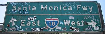
. However, it is not actually a scenic highway as designated by Caltrans. The Santa Monica Freeway is Route 10 from Route 1 to Route 5, as named by the State Highway Commission on April 25, 1957. The section between the Harbor and San Diego
freeways is also signed as the Rosa Parks
Freeway. This freeway is signed as the Christopher Columbus Transcontinental Highway in Santa Monica
.
The Rosa Parks Freeway is Route 10 from Route 110 to Route 405, as named by Assembly Concurrent Resolution 134, Chapter 2 in 2002.
and ending southeast of downtown Los Angeles
at the East Los Angeles Interchange
.
 Interstate 10 begins in the city of Santa Monica
when State Route 1 turns into a freeway and heads east. SR 1 exits onto Lincoln Boulevard and heads south while I-10 continues east. Soon after it enters the city of Los Angeles
, I-10 has a four-level interchange with Interstate 405
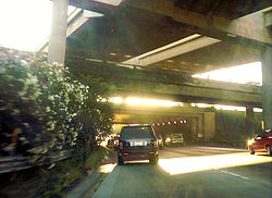
. Interstate 10 then continues through Jefferson Park
into downtown Los Angeles. On the western edge of downtown, I-10 has an interchange with Interstate 110
to the south and State Route 110 to the north. I-10 then travels along the southern edge of downtown to the East Los Angeles Interchange.
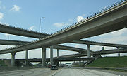
 At the East Los Angeles Interchange, State Route 60 diverges east towards Riverside
and Pomona
. I-10 then turns north, running concurrently with Interstate 5 for a few miles. Then, Interstate 10 heads east and merges with the traffic from the spur to US 101 onto the San Bernardino Freeway.
 The freeway is 14 lanes wide (two local, five express in each direction) from the Harbor Freeway (Interstate 110
) interchange to the Arlington Avenue off-ramp, Most of these lanes are full at peak travel times (even on Saturdays). The remainder of the freeway varies between eight and 10 lanes in width. The whole freeway (much smaller than) was opened in 1964.
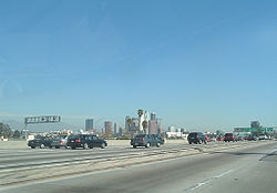
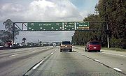
While the construction of the Century Freeway several miles to the south reduced traffic congestion
to a considerable amount by creating an alternate route from downtown to the Los Angeles International Airport
, the Santa Monica Freeway is still one of the busiest freeways in the world. All three freeway-to-freeway interchanges along its length are notorious for their congestion, and they are routinely ranked among the top 10 most congested spots in the United States
.
Due to the high traffic volume, car accident
s are so common that Caltrans has constructed special Accident Investigation Sites separated from the freeway by fences. These enable the California Highway Patrol
to quickly clear accidents from the through traffic lanes, and the fences reduce congestion by preventing rubbernecking
(where cars slow so their occupants may watch the accident investigation).
) near downtown Los Angeles. This section of roadway, the westernmost part of the San Bernardino Freeway
, was part of the original San Benardino Freeway, carrying U.S. Route 60, U.S. Route 70 and U.S. Route 99 long before the Golden State Freeway opened. It was added to the Interstate Highway System
by 1958 as Interstate 110, but in 1968 it was removed from the system, becoming a Route 10 spur.
This road is signed only for the roads it feeds into — US 101 North westbound and I-10 East eastbound. It has no interchange
s except its ends, although there is a westbound exit off of the spur at Mission Rd. immediately before merging with U.S. Route 101. The exit number
s for I-10 is to follow the signed route of I-10 West along with I-5 South, but one exit on Route 10 - the eastbound for State Street and Soto Street before it merges onto I-10 Eastbound — is numbered (as exit 19).
There is no access from this spur eastbound to I-5 Northbound or from I-5 Southbound to the westbound spur.
 Interstate 10 heads east from Los Angeles, with two HOV lanes paralleling it on the north side called the El Monte Busway
. These roadways extend to Alameda Street on US 101, following the spur west to where I-10 passes California State University Los Angeles. However, after the Interstate 710 interchange, these lanes merge back into the typical left lanes of each roadway.
East of Interstate 710, I-10 continues through Monterey Park
, Alhambra
, Rosemead
, San Gabriel
, El Monte
, and Baldwin Park
before intersecting with Interstate 605. It then travels through West Covina and Covina before heading up Kellogg Hill into San Dimas
, where I-10 intersects with State Route 57 (formerly part of Interstate 210
) and State Route 71. I-10 then heads east through Pomona
and Claremont
into San Bernardino County
.
 In San Bernardino County, Interstate 10 travels through Montclair
, Upland
, and Ontario
, providing access to Ontario International Airport
. I-10 then has a four-level interchange with Interstate 15 before traveling through Fontana
, Rialto
, and Colton
. I-10 then intersects with Interstate 215
before briefly entering San Bernardino
city proper and traveling through Loma Linda
and Redlands
. In Redlands, I-10 intersects with the State Route 210 freeway (future Interstate 210) and with State Route 38 before entering Yucaipa
and eventually Riverside County
.
before entering Beaumont
and merging with the eastern end of State Route 60 (itself formerly the California segment of US 60). In Banning
, I-10 has a diamond intersection with State Route 243 before passing through San Gorgonio Pass
between the San Bernardino Mountains
and the San Jacinto Mountains
and entering Palm Springs
. I-10 intersects with the western end of State Route 111, whereas I-10 bypasses the town and connects to State Route 62, a major east–west route through the Mojave Desert
. I-10 cuts through Cathedral City
and passes just outside the city limits of Rancho Mirage
, Palm Desert
, and Indian Wells
before entering Indio
and running concurrently with State Route 111. I-10 then has an interchange in Coachella
with the northern end of the State Route 86S
freeway, which also carries the routing of SR-111. Past Coachella, I-10 traverses the Mojave Desert, with few junctions and no cities. Several miles east and roughly halfway between Indio and Blythe
, in the community of Desert Center
, I-10 intersects with State Route 177
, a turnoff that connects to SR-62. Near the Arizona state line, I-10 meets the terminus of State Route 78. In the city of Blythe, I-10 runs concurrently with U.S. Route 95
as both routes cross the Colorado River
into Arizona
.
I-10 westbound is usually signed as towards San Bernardino and/or Los Angeles in the Mojave Desert. Eastbound, in the San Gorgonio Pass
, the signage indicates "Indio, Other Desert Cities", and indicates "Blythe" after Indio — the first sign for Phoenix does not occur until after the SR 86S exit in Coachella
.
 What is now Interstate 10 east of Los Angeles was generally part of the Atlantic and Pacific Highway
, one of many transcontinental national auto trail
s. By 1926, when the United States Numbered Highways
were assigned, the road across the desert east of Indio
was unimproved, while the road from Indio west to San Bernardino (as well as various roads west to Los Angeles) was paved. In late 1926, U.S. Route 99 was designated along the section of road from San Bernardino to Indio, where it turned south along present State Route 86 on the west side of the Salton Sea
. West of San Bernardino, US 99 ran to Los Angeles
concurrent with U.S. Route 66 (via Pasadena) before turning north; this route to Los Angeles is north of the later alignment of Interstate 10. The piece of this between San Bernardino and Indio was defined in 1915 as Legislative Route 26. (It continued south from Indio via El Centro
to Heber
; see U.S. Route 99 and State Route 86 for details. A 1931 extension took it south to Calexico
on present State Route 111.)
The route from Indio via Mecca
to the Arizona
state line near Blythe
was defined in 1919 as pre-1964 Legislative Route 64. (Later extensions took LR 64 west along present State Route 74; a 1931 cutoff bypassed Mecca to the north.) LR 26 was extended west from San Bernardino to Los Angeles in 1931, running along an alignment south of the existing US 66/US 99. Neither of these was a signed route until ca. 1932, when U.S. Route 60 was extended west from Arizona to Los Angeles, running along LR 64 to Indio, LR 26 (with US 99) to Beaumont
, pre-1964 Legislative Route 19 to Pomona
, and LR 26 to Los Angeles. (The original alignment of LR 26 ran roughly where State Route 60 now is west of Pomona, but an alignment close to present I-10 opened ca. 1934.
Thus, in 1931, what is now I-10 east of Los Angeles had been defined as LR 26 from Los Angeles to Indio and LR 64 from Indio to Arizona. It was signed as US 99 from San Bernardino to Indio, and US 60 came along ca. 1932 from Los Angeles to Pomona and from Beaumont to Arizona. U.S. Route 70 was extended west from Arizona ca. 1936 along the whole route to Los Angeles, and, between 1933 and 1942, US 99 moved from US 66 to present I-10 between San Bernardino and Los Angeles, forming a three-way concurrency
between Pomona and Los Angeles. Old alignments and names include Valley Boulevard
, Ramona Boulevard and Garvey Avenue
.
The route east from Los Angeles was added to the Interstate Highway System
on August 7, 1947. It was assigned the I-10 number on August 14, 1957, and the short piece west of I-5 was approved as I-110 on November 10, 1958. By then, most if not all of the San Bernardino Freeway
had been completed, and I-10 was signed along the existing freeway along with US 70, US 99, and part of US 60. Those three routes were all removed in the 1964 renumbering
, leaving only I-10.
The part west of downtown Los Angeles was pre-1964 Legislative Route 173, defined in 1933 from Santa Monica to downtown Los Angeles. It was signed as State Route 26 by 1942, running along Olympic Boulevard
. It was later replaced by the Santa Monica Freeway, and added to the Interstate Highway System
on September 15, 1955. It too was assigned the I-10 number on August 14, 1957. It was completed ca. 1964, and became Route 10 in the 1964 renumbering
.
Portions of the Santa Monica Freeway going over La Cienega Boulevard collapsed after the Northridge earthquake
on January 17, 1994, and were rebuilt using new Seismic-Resistant bridge designs.
, a National Park Service
unit in the United States
National Historic Trail
and National Millennium Trail
programs. A Brochure Map for driving and detailed Anza Maps by County, with a Historical destinations-events Guide, an Anza Trail Guide for hiking , and the official NPS: Juan Bautista de Anza National Historic Trail website are all available for information.
In 2005, Caltrans began posting signs on roads that overlap with the historic 1776 Juan Bautista de Anza
trail route, so that California drivers can now follow the trail.
, Caltrans has a few projects on the books to relieve the traffic congestion. A plan to add high-occupancy vehicle lane
s between Ontario and Redlands, and a project to widen I-10 from Yucaipa to Redlands (which has been completed), are both being funded in part by San Bernardino County's Measure I, which established a half-cent transportation sales tax.
Southern United States
The Southern United States—commonly referred to as the American South, Dixie, or simply the South—constitutes a large distinctive area in the southeastern and south-central United States...
, runs in the U.S. state of California
California
California is a state located on the West Coast of the United States. It is by far the most populous U.S. state, and the third-largest by land area...
east from Santa Monica
Santa Monica, California
Santa Monica is a beachfront city in western Los Angeles County, California, US. Situated on Santa Monica Bay, it is surrounded on three sides by the city of Los Angeles — Pacific Palisades on the northwest, Brentwood on the north, West Los Angeles on the northeast, Mar Vista on the east, and...
, on the Pacific Ocean
Pacific Ocean
The Pacific Ocean is the largest of the Earth's oceanic divisions. It extends from the Arctic in the north to the Southern Ocean in the south, bounded by Asia and Australia in the west, and the Americas in the east.At 165.2 million square kilometres in area, this largest division of the World...
, through Los Angeles
Los Angeles, California
Los Angeles , with a population at the 2010 United States Census of 3,792,621, is the most populous city in California, USA and the second most populous in the United States, after New York City. It has an area of , and is located in Southern California...
and San Bernardino
San Bernardino, California
San Bernardino is a city located in the Riverside-San Bernardino metropolitan area , and serves as the county seat of San Bernardino County, California, United States...
to the border with Arizona
Arizona
Arizona ; is a state located in the southwestern region of the United States. It is also part of the western United States and the mountain west. The capital and largest city is Phoenix...
. In the greater Los Angeles area, it is known as the Santa Monica Freeway and the San Bernardino Freeway, linked by a short concurrency
Concurrency (road)
A concurrency, overlap, or coincidence in a road network is an instance of one physical road bearing two or more different highway, motorway, or other route numbers...
on Interstate 5 (the Golden State Freeway) at the East Los Angeles Interchange
East Los Angeles Interchange
The East Los Angeles Interchange complex is the busiest freeway interchange in the world, with its southern portion handling over 550,000 vehicles per day . The northern portion, called the San Bernardino Split, is often considered a separate interchange. The interchange was named the Eugene A....
. At the East LA Interchange, a short piece of the San Bernardino Freeway west of I-5 is part of the legislative definition of Route 10, but does not carry Interstate 10. This section of freeway, once a short Interstate 110 until 1968, is signed for I-10 eastbound and for U.S. Route 101 (its terminus, at the Santa Ana Freeway
Santa Ana Freeway
The Santa Ana Freeway is one of the principal freeways in Southern California, connecting Los Angeles and its southeastern suburbs including the freeway's namesake, the city of Santa Ana. The freeway begins at the Four Level Interchange in downtown Los Angeles, signed as U.S. Route 101...
) westbound.
Route description
I-10 is part of the California Freeway and Expressway SystemCalifornia Freeway and Expressway System
The California Freeway and Expressway System is a system of existing or planned freeways and expressways in the U.S. state of California. It is defined by the Streets and Highways Code.-List of roads in the system:*State Route 1 *State Route 2...
and is eligible for the State Scenic Highway System
State Scenic Highway System (California)
The State Scenic Highway System is a list of highways, mainly state highways, that have been designated by the California Department of Transportation as scenic highways. The California State Legislature, primarily through Section 263 of the Streets and Highways Code, makes highways eligible for...
. However, it is not actually a scenic highway as designated by Caltrans. The Santa Monica Freeway is Route 10 from Route 1 to Route 5, as named by the State Highway Commission on April 25, 1957. The section between the Harbor and San Diego
Interstate 405 (California)
Interstate 405 is a major north–south Interstate Highway in Southern California. It is a bypass of Interstate 5, running along the western areas of the Greater Los Angeles Area from Irvine in the south to near San Fernando in the north...
freeways is also signed as the Rosa Parks
Rosa Parks
Rosa Louise McCauley Parks was an African-American civil rights activist, whom the U.S. Congress called "the first lady of civil rights", and "the mother of the freedom movement"....
Freeway. This freeway is signed as the Christopher Columbus Transcontinental Highway in Santa Monica
Santa Mônica
Santa Mônica is a town and municipality in the state of Paraná in the Southern Region of Brazil.-References:...
.
The Rosa Parks Freeway is Route 10 from Route 110 to Route 405, as named by Assembly Concurrent Resolution 134, Chapter 2 in 2002.
Santa Monica Freeway
The Santa Monica Freeway is the westernmost segment of Interstate 10, beginning at the western terminus of I-10 at the Pacific Coast Highway in Santa Monica, CaliforniaSanta Monica, California
Santa Monica is a beachfront city in western Los Angeles County, California, US. Situated on Santa Monica Bay, it is surrounded on three sides by the city of Los Angeles — Pacific Palisades on the northwest, Brentwood on the north, West Los Angeles on the northeast, Mar Vista on the east, and...
and ending southeast of downtown Los Angeles
Los Angeles, California
Los Angeles , with a population at the 2010 United States Census of 3,792,621, is the most populous city in California, USA and the second most populous in the United States, after New York City. It has an area of , and is located in Southern California...
at the East Los Angeles Interchange
East Los Angeles Interchange
The East Los Angeles Interchange complex is the busiest freeway interchange in the world, with its southern portion handling over 550,000 vehicles per day . The northern portion, called the San Bernardino Split, is often considered a separate interchange. The interchange was named the Eugene A....
.
Santa Monica, California
Santa Monica is a beachfront city in western Los Angeles County, California, US. Situated on Santa Monica Bay, it is surrounded on three sides by the city of Los Angeles — Pacific Palisades on the northwest, Brentwood on the north, West Los Angeles on the northeast, Mar Vista on the east, and...
when State Route 1 turns into a freeway and heads east. SR 1 exits onto Lincoln Boulevard and heads south while I-10 continues east. Soon after it enters the city of Los Angeles
Los Angeles, California
Los Angeles , with a population at the 2010 United States Census of 3,792,621, is the most populous city in California, USA and the second most populous in the United States, after New York City. It has an area of , and is located in Southern California...
, I-10 has a four-level interchange with Interstate 405
Interstate 405 (California)
Interstate 405 is a major north–south Interstate Highway in Southern California. It is a bypass of Interstate 5, running along the western areas of the Greater Los Angeles Area from Irvine in the south to near San Fernando in the north...
. Interstate 10 then continues through Jefferson Park
Jefferson Park, Los Angeles, California
-Geography and transportation:Jefferson Park's boundaries are, roughly, Western Avenue on the east, Adams on the north, Crenshaw Boulevard on the west, and Exposition Boulevard/Rodeo Road on the south. It is bordered by Arlington Heights on the north, Mid-City on the northwest, Leimert Park/King...
into downtown Los Angeles. On the western edge of downtown, I-10 has an interchange with Interstate 110
Interstate 110 (California)
Route 110, consisting of two segments of State Route 110 joined by Interstate 110 , is a state highway in the Los Angeles area of the U.S. state of California, mostly built to freeway standards...
to the south and State Route 110 to the north. I-10 then travels along the southern edge of downtown to the East Los Angeles Interchange.
Riverside, California
Riverside is a city in Riverside County, California, United States, and the county seat of the eponymous county. Named for its location beside the Santa Ana River, it is the largest city in the Riverside-San Bernardino-Ontario metropolitan area of Southern California, 4th largest inland California...
and Pomona
Pomona, California
-2010:The 2010 United States Census reported that Pomona had a population of 149,058, a slight decline from the 2000 census population. The population density was 6,491.2 people per square mile...
. I-10 then turns north, running concurrently with Interstate 5 for a few miles. Then, Interstate 10 heads east and merges with the traffic from the spur to US 101 onto the San Bernardino Freeway.
Interstate 110
Interstate 110 may refer to:*Interstate 110 , a north-south freeway running through Los Angeles, California*Interstate 110 , a spur route in Pensacola, Florida*Interstate 110 , a spur route in Baton Rouge, Louisiana...
) interchange to the Arlington Avenue off-ramp, Most of these lanes are full at peak travel times (even on Saturdays). The remainder of the freeway varies between eight and 10 lanes in width. The whole freeway (much smaller than) was opened in 1964.
While the construction of the Century Freeway several miles to the south reduced traffic congestion
Traffic congestion
Traffic congestion is a condition on road networks that occurs as use increases, and is characterized by slower speeds, longer trip times, and increased vehicular queueing. The most common example is the physical use of roads by vehicles. When traffic demand is great enough that the interaction...
to a considerable amount by creating an alternate route from downtown to the Los Angeles International Airport
Los Angeles International Airport
Los Angeles International Airport is the primary airport serving the Greater Los Angeles Area, the second-most populated metropolitan area in the United States. It is most often referred to by its IATA airport code LAX, with the letters pronounced individually...
, the Santa Monica Freeway is still one of the busiest freeways in the world. All three freeway-to-freeway interchanges along its length are notorious for their congestion, and they are routinely ranked among the top 10 most congested spots in the United States
United States
The United States of America is a federal constitutional republic comprising fifty states and a federal district...
.
Due to the high traffic volume, car accident
Car accident
A traffic collision, also known as a traffic accident, motor vehicle collision, motor vehicle accident, car accident, automobile accident, Road Traffic Collision or car crash, occurs when a vehicle collides with another vehicle, pedestrian, animal, road debris, or other stationary obstruction,...
s are so common that Caltrans has constructed special Accident Investigation Sites separated from the freeway by fences. These enable the California Highway Patrol
California Highway Patrol
The California Highway Patrol is a law enforcement agency of the U.S. state of California. The CHP has patrol jurisdiction over all California highways and also acts as the state police....
to quickly clear accidents from the through traffic lanes, and the fences reduce congestion by preventing rubbernecking
Rubbernecking
Rubbernecking describes the act of gawking at something of interest. It is often used to refer to drivers trying to view the carnage resulting from a traffic accident. The term refers to the craning of a person's neck in order to get a better view....
(where cars slow so their occupants may watch the accident investigation).
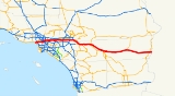
Spur to US 101
The legislative definition of Route 10 includes a spur from Interstate 5 (the Golden State Freeway) west to U.S. Route 101 (the Santa Ana FreewaySanta Ana Freeway
The Santa Ana Freeway is one of the principal freeways in Southern California, connecting Los Angeles and its southeastern suburbs including the freeway's namesake, the city of Santa Ana. The freeway begins at the Four Level Interchange in downtown Los Angeles, signed as U.S. Route 101...
) near downtown Los Angeles. This section of roadway, the westernmost part of the San Bernardino Freeway
San Bernardino Freeway
The San Bernardino Freeway, formerly known as the Ramona Freeway is a freeway in Los Angeles and Orange Counties in the southern part of the U.S. state of California. It refers to the following two segments:...
, was part of the original San Benardino Freeway, carrying U.S. Route 60, U.S. Route 70 and U.S. Route 99 long before the Golden State Freeway opened. It was added to the Interstate Highway System
Interstate Highway System
The Dwight D. Eisenhower National System of Interstate and Defense Highways, , is a network of limited-access roads including freeways, highways, and expressways forming part of the National Highway System of the United States of America...
by 1958 as Interstate 110, but in 1968 it was removed from the system, becoming a Route 10 spur.
This road is signed only for the roads it feeds into — US 101 North westbound and I-10 East eastbound. It has no interchange
Interchange (road)
In the field of road transport, an interchange is a road junction that typically uses grade separation, and one or more ramps, to permit traffic on at least one highway to pass through the junction without directly crossing any other traffic stream. It differs from a standard intersection, at which...
s except its ends, although there is a westbound exit off of the spur at Mission Rd. immediately before merging with U.S. Route 101. The exit number
Exit number
An exit number is a number assigned to a road junction, usually an exit from a freeway. It is usually marked on the same sign as the destinations of the exit, as well as a sign in the gore....
s for I-10 is to follow the signed route of I-10 West along with I-5 South, but one exit on Route 10 - the eastbound for State Street and Soto Street before it merges onto I-10 Eastbound — is numbered (as exit 19).
There is no access from this spur eastbound to I-5 Northbound or from I-5 Southbound to the westbound spur.
San Bernardino Freeway
El Monte Busway
The El Monte Busway is a 11 mile shared-use bus corridor and high occupancy vehicle lane running west along the Interstate 10 from the Interstate 605 and El Monte Bus Station via transitway stations at California State University Metro Station, USC Medical Center Metro Station into Downtown Los...
. These roadways extend to Alameda Street on US 101, following the spur west to where I-10 passes California State University Los Angeles. However, after the Interstate 710 interchange, these lanes merge back into the typical left lanes of each roadway.
East of Interstate 710, I-10 continues through Monterey Park
Monterey Park, California
Monterey Park is a city in Los Angeles County, California, United States, east of downtown Los Angeles. The city's motto is "Pride in the past, Faith in the future"...
, Alhambra
Alhambra, California
Alhambra is a city located in the western San Gabriel Valley region of Los Angeles County, California, United States, which is approximately eight miles from the Downtown Los Angeles civic center. As of the 2010 census, the population was 83,089, down from 85,804 at the 2000 census. The city's...
, Rosemead
Rosemead, California
Rosemead is a city in Los Angeles County, California, United States. As of the 2010 census, it had a population of 53,764. Rosemead is part of a cluster of cities, along with Arcadia, Temple City, Monterey Park, San Marino, and San Gabriel, in the west San Gabriel Valley with a growing Asian...
, San Gabriel
San Gabriel, California
San Gabriel is a city in Los Angeles County, California, United States. It is named after the Mission San Gabriel Arcángel, founded by Junipero Serra. The city grew outward from the mission and in 1852 became the original township of Los Angeles County. San Gabriel was incorporated in 1913...
, El Monte
El Monte, California
El Monte is a residential, industrial, and commercial city in Los Angeles County, California, United States. The city's slogan is "Welcome to Friendly El Monte," and historically is known as "The End of the Santa Fe Trail." As of the 2010 census, the city had a total population of 113,475,...
, and Baldwin Park
Baldwin Park, California
Baldwin Park is a city located in the central San Gabriel Valley region of Los Angeles County, California, United States. As of the 2010 census, the population was 75,390, down from 75,837 at the 2000 census.- History :...
before intersecting with Interstate 605. It then travels through West Covina and Covina before heading up Kellogg Hill into San Dimas
San Dimas, California
San Dimas is a city located in the San Gabriel Valley, in Los Angeles County, California. As of the 2010 census, the city had a total population of 33,371. The city historically took its name from San Dismas Canyon in the San Gabriel Mountains above the northern section of present day San Dimas...
, where I-10 intersects with State Route 57 (formerly part of Interstate 210
Interstate 210 (California)
Interstate 210 and State Route 210 together form a contiguous highway, called the Foothill Freeway, in the Greater Los Angeles area of the U.S. state of California. The western portion of the route is an auxiliary Interstate Highway, while the eastern portion is a state highway...
) and State Route 71. I-10 then heads east through Pomona
Pomona, California
-2010:The 2010 United States Census reported that Pomona had a population of 149,058, a slight decline from the 2000 census population. The population density was 6,491.2 people per square mile...
and Claremont
Claremont, California
Claremont is a small affluent college town in eastern Los Angeles County, California, United States, about east of downtown Los Angeles at the base of the San Gabriel Mountains. The population as of the 2010 census is 34,926. Claremont is known for its seven higher-education institutions, its...
into San Bernardino County
San Bernardino County, California
San Bernardino County is a county in the U.S. state of California. As of the 2010 census, the population was 2,035,210, up from 1,709,434 as of the 2000 census...
.
Montclair, California
Montclair is a city in San Bernardino County, California, United States. The population was 36,664 at the 2010 United States Census.The current mayor is Paul M. Eaton.-Description:...
, Upland
Upland, California
Upland is a city in San Bernardino County, California, located at an elevation of 1,242 feet . As of the 2010 census, the city had a population of 73,732, up from 68,393 at the 2000 census. It was incorporated on May 15, 1906, after previously being named North Ontario.-History and culture:Upland...
, and Ontario
Ontario, California
Ontario is a city located in San Bernardino County, California, United States, 35 miles east of downtown Los Angeles. Located in the western part of the Inland Empire region, it lies just east of the Los Angeles county line and is part of the Greater Los Angeles Area...
, providing access to Ontario International Airport
Ontario International Airport
LA/Ontario International Airport , formerly Ontario International Airport, is a public airport located east of the central business district of Ontario, a city in San Bernardino County, California, USA. This airport is owned and operated by the Los Angeles World Airports , an agency of the city...
. I-10 then has a four-level interchange with Interstate 15 before traveling through Fontana
Fontana, California
Fontana is a city of 196,069 residents in San Bernardino County, California. Founded in 1913, it remained essentially rural until World War II, when entrepreneur Henry J. Kaiser built a large steel mill in the area...
, Rialto
Rialto, California
-2010:The 2010 United States Census reported that Rialto had a population of 99,171. The population density was 4,434.1 people per square mile . The racial makeup of Rialto was 43,592 White, 16,236 African American, 1,062 Native American, 2,258 Asian, 361 Pacific Islander, 30,993 from other...
, and Colton
Colton, California
Colton is a city in San Bernardino County, California, United States. The city is located in the Inland Empire region of the state and is approximately 57 miles east of Los Angeles. The population of Colton is 52,154 according to the 2010 census, up from 47,662 at the 2000 census.Colton is the...
. I-10 then intersects with Interstate 215
Interstate 215 (California)
Interstate 215 is a long north–south Interstate highway in the Inland Empire region of Southern California. It is an auxiliary route of Interstate 15 , running from Murrieta to northern San Bernardino...
before briefly entering San Bernardino
San Bernardino, California
San Bernardino is a city located in the Riverside-San Bernardino metropolitan area , and serves as the county seat of San Bernardino County, California, United States...
city proper and traveling through Loma Linda
Loma Linda, California
Loma Linda is a city in San Bernardino County, California, United States, that was incorporated in 1970. The population was 23,261 at the 2010 census, up from 18,681 at the 2000 census...
and Redlands
Redlands, California
Redlands is a city in San Bernardino County, California, United States. As of the 2010 census, the city had a population of 68,747, up from 63,591 at the 2000 census. The city is located east of downtown San Bernardino.- History :...
. In Redlands, I-10 intersects with the State Route 210 freeway (future Interstate 210) and with State Route 38 before entering Yucaipa
Yucaipa, California
Yucaipa is a city located east of San Bernardino, in San Bernardino County, California, United States. The population was 51,367 at the 2010 census, up from 41,207 at the 2000 census...
and eventually Riverside County
Riverside County, California
Riverside County is a county in the U.S. state of California. One of 58 California counties, it covers in the southern part of the state, and stretches from Orange County to the Colorado River, which forms the state border with Arizona. The county derives its name from the city of Riverside,...
.
Riverside County
In Riverside County, I-10 goes through CalimesaCalimesa, California
Calimesa is a city in Riverside County, California, United States in the Greater Los Angeles area. The population was 7,879 at the 2010 census, up from 7,139 at the 2000 census. It is situated on the San Gorgonio Pass.-Incorporation:...
before entering Beaumont
Beaumont, California
Beaumont is a city in Riverside County, California, United States in the Greater Los Angeles area.Now a growing, community planned city, the population was 36,877 at the 2010 census, and expected to be up to 125,000 projected by 2040, making Beaumont as California's next, newest fastest-growing...
and merging with the eastern end of State Route 60 (itself formerly the California segment of US 60). In Banning
Banning, California
-2010:The 2010 United States Census reported that Banning had a population of 29,603. The population density was 1,281.6 people per square mile . The racial makeup of Banning was 19,164 White, 2,165 African American, 641 Native American, 1,549 Asian, 39 Pacific Islander, 4,604 from other...
, I-10 has a diamond intersection with State Route 243 before passing through San Gorgonio Pass
San Gorgonio Pass
The San Gorgonio Pass el. cuts between the San Bernardino Mountains on the north and the San Jacinto Mountains to the south. Like the Cajon Pass to the northwest, it was also created by the San Andreas Fault...
between the San Bernardino Mountains
San Bernardino Mountains
The San Bernardino Mountains are a short transverse mountain range north and east of San Bernardino in Southern California in the United States. The mountains run for approximately 60 miles east-west on the southern edge of the Mojave Desert in southwestern San Bernardino County, north of the...
and the San Jacinto Mountains
San Jacinto Mountains
The San Jacinto Mountains are a mountain range east of Los Angeles in southern California in the United States. The mountains are named for Saint Hyacinth . The Pacific Crest Trail runs along the spine of the range.The range extends for approximately from the San Bernardino Mountains southeast to...
and entering Palm Springs
Palm Springs, California
Palm Springs is a desert city in Riverside County, California, within the Coachella Valley. It is located approximately 37 miles east of San Bernardino, 111 miles east of Los Angeles and 136 miles northeast of San Diego...
. I-10 intersects with the western end of State Route 111, whereas I-10 bypasses the town and connects to State Route 62, a major east–west route through the Mojave Desert
Mojave Desert
The Mojave Desert occupies a significant portion of southeastern California and smaller parts of central California, southern Nevada, southwestern Utah and northwestern Arizona, in the United States...
. I-10 cuts through Cathedral City
Cathedral City, California
Cathedral City is a city in Riverside County, California, United States. The population was 51,200 at the 2010 census. Sandwiched between Palm Springs and Rancho Mirage, it is one of the cities in the Coachella Valley of southern California...
and passes just outside the city limits of Rancho Mirage
Rancho Mirage, California
Rancho Mirage is a resort city in Riverside County, California, United States. The population was 17,218 at the 2010 census, up from 13,249 at the 2000 census, but the seasonal population can exceed 20,000. In between Cathedral City and Palm Desert, it is one of the eight cities of the Coachella...
, Palm Desert
Palm Desert, California
Palm Desert is a city in Riverside County, California, United States, in the Coachella Valley, approximately east of Palm Springs. The population was 48,445 at the 2010 census, up from 41,155 at the 2000 census...
, and Indian Wells
Indian Wells, California
Indian Wells is a city in Riverside County, California, in the Coachella Valley , in between Palm Desert and La Quinta. As of the 2010 census, the city population was 4,958....
before entering Indio
Indio, California
Indio is a city in Riverside County, California, United States, located in the Coachella Valley of Southern California's Colorado Desert region. It lies east of Palm Springs, east of Riverside, and east of Los Angeles. It is about north of Mexicali, Baja California on the U.S.-Mexican border...
and running concurrently with State Route 111. I-10 then has an interchange in Coachella
Coachella, California
Coachella is a city in Riverside County, California; it is the easternmost city in the region collectively known as the Coachella Valley...
with the northern end of the State Route 86S
State Route 86S (California)
State Route 86S is an expressway in the U.S. state of California that runs through the Coachella Valley. In the future this will become State Route 86; however, this is currently a bypass of it. State Route 195 was supposed to be removed from the state highway system when this road was completed...
freeway, which also carries the routing of SR-111. Past Coachella, I-10 traverses the Mojave Desert, with few junctions and no cities. Several miles east and roughly halfway between Indio and Blythe
Blythe, California
Blythe is a city in Riverside County, California, United States, in the "Palo Verde Valley" of the Lower Colorado River Valley region, an agricultural area and part of the Colorado Desert along the Colorado River. Blythe was named after Thomas Blythe, a gold prospector who established primary...
, in the community of Desert Center
Desert Center, California
-"Desert Steve" Ragsdale:The town was founded in 1921 by Stephen A. Ragsdale, also known as “Desert Steve”, and his wife, Lydia. Ragsdale was an itinerant preacher and cotton farmer, originally from Arkansas. In 1915, he left his farm in the Palo Verde Valley along the Colorado River to attend to...
, I-10 intersects with State Route 177
State Route 177 (California)
State Route 177 is a short state highway in the U.S. state of California in Riverside County. The route links Interstate 10 midway between the Coachella Valley and Blythe on the California/Arizona border, to State Route 62 near Rice. SR 177 travels along the eastern portion of the Joshua Tree...
, a turnoff that connects to SR-62. Near the Arizona state line, I-10 meets the terminus of State Route 78. In the city of Blythe, I-10 runs concurrently with U.S. Route 95
U.S. Route 95 in California
In the U.S. state of California, U.S. Route 95 traverses through the far eastern edges of both Riverside and San Bernardino counties. US 95 serves Blythe and Needles and junctions with SR 62 at Vidal Junction....
as both routes cross the Colorado River
Colorado River
The Colorado River , is a river in the Southwestern United States and northwestern Mexico, approximately long, draining a part of the arid regions on the western slope of the Rocky Mountains. The watershed of the Colorado River covers in parts of seven U.S. states and two Mexican states...
into Arizona
Arizona
Arizona ; is a state located in the southwestern region of the United States. It is also part of the western United States and the mountain west. The capital and largest city is Phoenix...
.
I-10 westbound is usually signed as towards San Bernardino and/or Los Angeles in the Mojave Desert. Eastbound, in the San Gorgonio Pass
San Gorgonio Pass
The San Gorgonio Pass el. cuts between the San Bernardino Mountains on the north and the San Jacinto Mountains to the south. Like the Cajon Pass to the northwest, it was also created by the San Andreas Fault...
, the signage indicates "Indio, Other Desert Cities", and indicates "Blythe" after Indio — the first sign for Phoenix does not occur until after the SR 86S exit in Coachella
Coachella, California
Coachella is a city in Riverside County, California; it is the easternmost city in the region collectively known as the Coachella Valley...
.
History
Atlantic and Pacific Highway
The Atlantic and Pacific Highway was an auto trail in the United States, essentially eliminated by the U.S. Highway system in the late 1920s. It connected New York City on the Atlantic Ocean with Los Angeles on the Pacific Ocean.-Routing:...
, one of many transcontinental national auto trail
National auto trail
The system of auto trails was an informal network of marked routes that existed in the United States and Canada in the early part of the 20th century. Marked with colored bands on telephone poles, the trails were intended to help travellers in the early days of the automobile.Auto trails were...
s. By 1926, when the United States Numbered Highways
United States Numbered Highways
The system of United States Numbered Highways is an integrated system of roads and highways in the United States numbered within a nationwide grid...
were assigned, the road across the desert east of Indio
Indio, California
Indio is a city in Riverside County, California, United States, located in the Coachella Valley of Southern California's Colorado Desert region. It lies east of Palm Springs, east of Riverside, and east of Los Angeles. It is about north of Mexicali, Baja California on the U.S.-Mexican border...
was unimproved, while the road from Indio west to San Bernardino (as well as various roads west to Los Angeles) was paved. In late 1926, U.S. Route 99 was designated along the section of road from San Bernardino to Indio, where it turned south along present State Route 86 on the west side of the Salton Sea
Salton Sea
The Salton Sea is a shallow, saline, endorheic rift lake located directly on the San Andreas Fault, predominantly in California's Imperial Valley. The lake occupies the lowest elevations of the Salton Sink in the Colorado Desert of Imperial and Riverside counties in Southern California. Like Death...
. West of San Bernardino, US 99 ran to Los Angeles
Los Angeles, California
Los Angeles , with a population at the 2010 United States Census of 3,792,621, is the most populous city in California, USA and the second most populous in the United States, after New York City. It has an area of , and is located in Southern California...
concurrent with U.S. Route 66 (via Pasadena) before turning north; this route to Los Angeles is north of the later alignment of Interstate 10. The piece of this between San Bernardino and Indio was defined in 1915 as Legislative Route 26. (It continued south from Indio via El Centro
El Centro, California
El Centro is a city in and county seat of Imperial County, the largest city in the Imperial Valley and the east anchor of the Southern California Border Region, and the core urban area and principal city of the El Centro metropolitan area which encompasses all of Imperial County. El Centro is also...
to Heber
Heber, California
Heber is a census-designated place in Imperial County, California. Heber is located north-northwest of Calexico. The population was 4,275 at the 2010 census, up from 2,566 at the 2000 census.-Geography:Heber is located at ....
; see U.S. Route 99 and State Route 86 for details. A 1931 extension took it south to Calexico
Calexico, California
Calexico is a city in Imperial County, California. The population was 38,572 at the 2010 census, up from 27,109 at the 2000 census. Calexico is about east of San Diego and west of Yuma, Arizona...
on present State Route 111.)
The route from Indio via Mecca
Mecca, California
Mecca is a census-designated place in Riverside County, California, United States. The population was 8,577 at the 2010 census, up from 5,402 at the 2000 census....
to the Arizona
Arizona
Arizona ; is a state located in the southwestern region of the United States. It is also part of the western United States and the mountain west. The capital and largest city is Phoenix...
state line near Blythe
Blythe, California
Blythe is a city in Riverside County, California, United States, in the "Palo Verde Valley" of the Lower Colorado River Valley region, an agricultural area and part of the Colorado Desert along the Colorado River. Blythe was named after Thomas Blythe, a gold prospector who established primary...
was defined in 1919 as pre-1964 Legislative Route 64. (Later extensions took LR 64 west along present State Route 74; a 1931 cutoff bypassed Mecca to the north.) LR 26 was extended west from San Bernardino to Los Angeles in 1931, running along an alignment south of the existing US 66/US 99. Neither of these was a signed route until ca. 1932, when U.S. Route 60 was extended west from Arizona to Los Angeles, running along LR 64 to Indio, LR 26 (with US 99) to Beaumont
Beaumont, California
Beaumont is a city in Riverside County, California, United States in the Greater Los Angeles area.Now a growing, community planned city, the population was 36,877 at the 2010 census, and expected to be up to 125,000 projected by 2040, making Beaumont as California's next, newest fastest-growing...
, pre-1964 Legislative Route 19 to Pomona
Pomona, California
-2010:The 2010 United States Census reported that Pomona had a population of 149,058, a slight decline from the 2000 census population. The population density was 6,491.2 people per square mile...
, and LR 26 to Los Angeles. (The original alignment of LR 26 ran roughly where State Route 60 now is west of Pomona, but an alignment close to present I-10 opened ca. 1934.
Thus, in 1931, what is now I-10 east of Los Angeles had been defined as LR 26 from Los Angeles to Indio and LR 64 from Indio to Arizona. It was signed as US 99 from San Bernardino to Indio, and US 60 came along ca. 1932 from Los Angeles to Pomona and from Beaumont to Arizona. U.S. Route 70 was extended west from Arizona ca. 1936 along the whole route to Los Angeles, and, between 1933 and 1942, US 99 moved from US 66 to present I-10 between San Bernardino and Los Angeles, forming a three-way concurrency
Concurrency (road)
A concurrency, overlap, or coincidence in a road network is an instance of one physical road bearing two or more different highway, motorway, or other route numbers...
between Pomona and Los Angeles. Old alignments and names include Valley Boulevard
Valley Boulevard
Valley Boulevard is a street in Southern California, running east from Los Angeles to Pomona, where it becomes Holt Boulevard, and a continuation from Fontana to Colton. It generally parallels Interstate 10 and State Route 60, and is the original alignment of U.S. Route 60...
, Ramona Boulevard and Garvey Avenue
Garvey Avenue
-Geography:Garvey Avenue starts off as Ramona Boulevard at Eastern Avenue in Los Angeles' Eastside. Upon entrance to Alhambra, the name changes to Garvey Avenue. In addition to Alhambra, it runs through cities like Monterey Park, Rosemead, and El Monte. It terminates at Durfee Avenue. For much...
.
The route east from Los Angeles was added to the Interstate Highway System
Interstate Highway System
The Dwight D. Eisenhower National System of Interstate and Defense Highways, , is a network of limited-access roads including freeways, highways, and expressways forming part of the National Highway System of the United States of America...
on August 7, 1947. It was assigned the I-10 number on August 14, 1957, and the short piece west of I-5 was approved as I-110 on November 10, 1958. By then, most if not all of the San Bernardino Freeway
San Bernardino Freeway
The San Bernardino Freeway, formerly known as the Ramona Freeway is a freeway in Los Angeles and Orange Counties in the southern part of the U.S. state of California. It refers to the following two segments:...
had been completed, and I-10 was signed along the existing freeway along with US 70, US 99, and part of US 60. Those three routes were all removed in the 1964 renumbering
1964 state highway renumbering (California)
In 1963 and 1964, the California Division of Highways implemented a major renumbering of its state highways. The majority of sign routes — those marked for the public — kept their numbers; the main changes were to the legislative routes, which had their numbers changed to match the sign routes...
, leaving only I-10.
The part west of downtown Los Angeles was pre-1964 Legislative Route 173, defined in 1933 from Santa Monica to downtown Los Angeles. It was signed as State Route 26 by 1942, running along Olympic Boulevard
Olympic Boulevard
Olympic Boulevard is a major arterial road in Los Angeles, California. It stretches from 4th Street on the western end of Santa Monica to East Los Angeles—farther than Wilshire Boulevard and most other streets....
. It was later replaced by the Santa Monica Freeway, and added to the Interstate Highway System
Interstate Highway System
The Dwight D. Eisenhower National System of Interstate and Defense Highways, , is a network of limited-access roads including freeways, highways, and expressways forming part of the National Highway System of the United States of America...
on September 15, 1955. It too was assigned the I-10 number on August 14, 1957. It was completed ca. 1964, and became Route 10 in the 1964 renumbering
1964 state highway renumbering (California)
In 1963 and 1964, the California Division of Highways implemented a major renumbering of its state highways. The majority of sign routes — those marked for the public — kept their numbers; the main changes were to the legislative routes, which had their numbers changed to match the sign routes...
.
Portions of the Santa Monica Freeway going over La Cienega Boulevard collapsed after the Northridge earthquake
Northridge earthquake
The Northridge earthquake was a massive earthquake that occurred on January 17, 1994, at 04:31 Pacific Standard Time in Reseda, a neighborhood in the city of Los Angeles, California, lasting for about 10–20 seconds...
on January 17, 1994, and were rebuilt using new Seismic-Resistant bridge designs.
Juan Bautista de Anza National Historic Trail
The U.S. I-10 Highway is part of the auto tour route of the Juan Bautista de Anza National Historic TrailJuan Bautista de Anza National Historic Trail
thumb|325px|MAP: [[Juan Bautista de Anza]] National Historic Trail routes in [[Arizona]] and [[California]].The Juan Bautista de Anza National Historic Trail is a National Park Service unit in the United States National Historic Trail and National Millennium Trail programs...
, a National Park Service
National Park Service
The National Park Service is the U.S. federal agency that manages all national parks, many national monuments, and other conservation and historical properties with various title designations...
unit in the United States
United States
The United States of America is a federal constitutional republic comprising fifty states and a federal district...
National Historic Trail
National Historic Trail
National Historic Trail is a designation for a protected area in the United States containing historic trails and surrounding areas. They are part of the National Trails System....
and National Millennium Trail
National Millennium Trail
National Millennium Trails are 16 long-distance trails selected from 58 nominees as visionary trails that reflect defining aspects America's history and culture...
programs. A Brochure Map for driving and detailed Anza Maps by County, with a Historical destinations-events Guide, an Anza Trail Guide for hiking , and the official NPS: Juan Bautista de Anza National Historic Trail website are all available for information.
In 2005, Caltrans began posting signs on roads that overlap with the historic 1776 Juan Bautista de Anza
Juan Bautista de Anza
Juan Bautista de Anza Bezerra Nieto was a Novo-Spanish explorer and Governor of New Mexico for the Spanish Empire.-Early life:...
trail route, so that California drivers can now follow the trail.
Future
With the increasing high traffic volume between Los Angeles and the San BernardinoSan Bernardino, California
San Bernardino is a city located in the Riverside-San Bernardino metropolitan area , and serves as the county seat of San Bernardino County, California, United States...
, Caltrans has a few projects on the books to relieve the traffic congestion. A plan to add high-occupancy vehicle lane
High-occupancy vehicle lane
In transportation engineering and transportation planning, a high-occupancy vehicle lane is a lane reserved for vehicles with a driver and one or more passengers...
s between Ontario and Redlands, and a project to widen I-10 from Yucaipa to Redlands (which has been completed), are both being funded in part by San Bernardino County's Measure I, which established a half-cent transportation sales tax.
Exit list
See also
- Lloyd G. DaviesLloyd G. DaviesLloyd G. Davies was a Hollywood advertising and public relations man and sometime actor who was a Los Angeles City Council member from 1943 to 1951.-Biography:...
, Los Angeles City Council member, 1943–51, urged rail transportation on the Santa Monica Freeway