

Imperial County, California
Encyclopedia
Imperial County is a county
located in the Imperial Valley, in the far southeast of the U.S. state
of California
, bordering both Arizona
and Mexico
. It is part of the El Centro Metropolitan Area, which encompasses all of Imperial County. The population as of 2000 was 142,361. The county seat
is the city
of El Centro
. Established in 1907, it was the last county to be established in California. Imperial County is also part of the Southern California
border region, also referred to as San Diego-Imperial, the smallest but most economically diverse region in the state.
Although this region is a desert, with high temperatures and low average rainfall of three inches (seventy-five mm) per year, the economy is heavily based on agriculture due to irrigation
, supplied wholly from the Colorado River
via the All-American Canal
.
The Imperial Valley is a melting pot of European American
and Hispanic cultures. On the American side, the majority of residents are of Mexican American
heritage, while the Mexican side was greatly influenced by American culture for many decades. The entire valley is a multi-racial mixture of European Americans, East Asian Americans, South Asian Americans, some African Americans and Native Americans
.
explorer Melchior Díaz was one of the first Europe
ans to visit the area around Imperial Valley in 1540. The explorer Juan Bautista de Anza
also explored the area in 1776. Years later, after the Mexican-American War, the northern half of the valley was annexed by the U.S., while the southern half remained under Mexican rule. Small scale settlement in natural aquifer areas occurred in the early 19th century (the present-day site of Mexicali
), but most permanent settlement (Anglo Americans in the U.S. side, Mexicans in the other side) was after 1900.
In 1905, torrential rainfall in the American Southwest caused the Colorado River (the only drainage for the region) to flood, including canals that had been built to irrigate the Imperial Valley. Since the valley is partially below sea level, the waters never fully receded, but collected in the Salton Sink
in what is now called the Salton Sea
, the world's only artificial inland sea.
Imperial County was formed in 1907 from the eastern portion of San Diego County
. The county took its name from Imperial Valley, itself named for the Imperial Land Company
, a subsidiary of the California Development Company
, which at the turn of the 20th century had claimed the southern portion of the Colorado desert for agriculture. Much of the Imperial Land Company's land also existed in Mexico (Baja California
). The objective of the company was commercial crop farming development.
By 1910, the land company had managed to settle and develop thousands of farms on both sides of the border. But the Mexican Revolution
severely disrupted the company's plans. Nearly 10,000 farmers and their families in Mexico were ethnically cleansed by the rival Mexican armies. Not until the 1920s was the other side of California in America sufficiently peaceful and prosperous for the company to earn a return for a large percentage of Mexicans, but some chose to stay and lay down roots in newly sprouted communities in the valley.
The county experienced a period of migration of "Okies" from drought-trodden dust bowl
farms by the need of migrant labor, and prosperous job-seekers alike from across the U.S. arrived in the 1930s and 1940s, especially in World War II
and after the completion of the All American Canal from its source, the Colorado River
, from 1948 to 1951. By the 1950 census, over 50,000 residents lived in Imperial County alone, about 40 times that of 1910. Most of the population was year-round but would increase every winter by migrant laborers from Mexico. Until the 1960s, the farms in Imperial County provided substantial economic returns to the company and the valley.
In the 2000's, the real estate boom and bust impacted Imperial County. Currently, El Centro has one of the U.S' highest unemployment rates (above 30-34%) and ranks one of the state's poorest counties or have a lower than state and national average annual household income.
is located on the banks of the Colorado River
in Winterhaven, California
. First established after the end of the Mexican-American War in 1848, it was originally located in the bottoms near the Colorado River, less than 1 miles (1.6 km) below the mouth of the Gila River
. It was to defend the newly settled community of Yuma, Arizona
on the other side of the Colorado River and the nearby Mexican border
. In March 1851 the post was moved to a small elevation on the Colorado's west bank, opposite the present city of Yuma, Arizona, on the site of the former Mission Puerto de Purísima Concepción
. This site had been occupied by Camp Calhoun, named for John C. Calhoun
, established in 1849. Fort Yuma was established to protect the southern emigrant travel route to California and to attempt control of the Yuma Indians in the surrounding 100 miles (160.9 km) area.
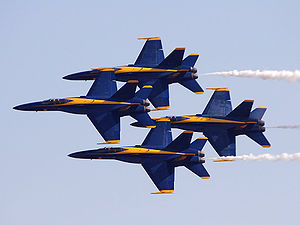 NAF El Centro is the winter home of the U.S. Navy Flight Demonstration Squadron, The Blue Angels
. NAF El Centro historically kicks off the Blue Angels' season with their first air show, traditionally held in March.
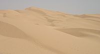 The name Algodones Dunes
refers to the entire geographic feature, while the administrative designation for that portion managed by the Bureau of Land Management
is the "Imperial Sand Dunes Recreation Area" (sometimes called the "Glamis Dunes"). The Algodones Sand Dunes are the largest mass of sand dunes in California. This dune system extends for more than 40 miles (64.4 km) along the eastern edge of the Imperial Valley
agricultural region in a band averaging 5 miles (8 km) in width. A major east-west route of the Union Pacific railroad skirts the eastern edge.The dune system is divided into 3 areas. The northern most area is known as Mammoth Wash. South of Mammoth Wash is the North Algodones Dunes Wilderness established by the 1994 California Desert Protection Act. This area is closed to motorized use and access is by hiking and horseback. The largest and most heavily used area begins at Highway 78
and continues south just past Interstate 8
. The expansive dune formations offer picturesque scenery,, a chance to view rare plants and animals, and a playground for ATV and off-roading enthusiasts. The dunes are also popular in film making and have been the site for movies such as Star Wars Episode VI: Return of the Jedi
.
is a river in the southwestern United States and northwestern Mexico, approximately 2330 kilometres (1,447.8 mi) long, draining a part of the arid regions on the western slope of the Rocky Mountains
. The natural course of the river flows from north of Grand Lake, Colorado into the Gulf of California
. For many months out of the year, however, no water actually flows from the United States to the gulf, due to human consumption. The river is a popular destination for water sports including fishing, boating, water-skiing, and jet-skiing.
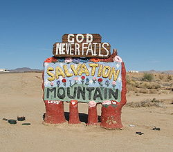 Salvation Mountain
(location 33°15′14.9"N 115°28′21.4"W) is a colorful artificial mountain north of Calipatria, California
, near Slab City
. It is made from adobe, straw, and thousands of gallons of paint. It was created by Leonard Knight
to convey the message that "God Loves Everyone". Knight refused substantial donations of money and labor from supporters who wished to modify his message of universal love to favor or disfavor particular groups.
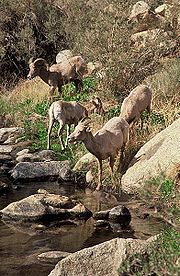 Anza-Borrego Desert State Park
, portions of which are located in Imperial County, is the largest state park in California
. 500 miles (804.7 km) of dirt roads, 12 wilderness areas and miles of hiking trails provide visitors with an unparalleled opportunity to experience the wonders of the Colorado Desert
. The park is named after Spanish explorer Juan Bautista de Anza
and the Spanish name borrego, or bighorn sheep
. The park features washes, wildflowers, palm groves, cacti
and sweeping vistas. Visitors may also have the chance to see roadrunner
, golden eagle
s, kit fox
es, mule deer
and bighorn sheep as well as iguanas, chuckwallas and the red diamond rattlesnake
.
in the Coyote Mountains
, Fossil Canyon and the surrounding area is a great place for rock hounding and fossil
hunting. The fossils here are not dinosaurs, but ancient shell
s, coral
, and oysters from the Miocene epoch
when the area was underwater.
The Painted Gorge, located on the eastern side of the Coyote Mountains, consists of sedimentary, metamorphic and igneous rocks. Heat
and movement over time has created fantastic shapes and colors. Oranges, reds, purples, and mauves mixed with browns and blacks create a palette of color as the sun illuminates and plays shadows upon this geologic wonder.
protects wildlife habitat along 30 miles (48.3 km) of the lower Colorado River
in Arizona
and California
, including the last un-channeled section before the river enters Mexico
. The river and its associated backwater lakes and wetlands are a green oasis, contrasting with the surrounding desert mountains. It is a refuge and breeding area for migratory birds and local desert wildlife.
is located 40 miles (64.4 km) north of the Mexican
border at the southern end of the Salton Sea
in California’s Imperial Valley
. Situated along the Pacific Flyway
, the refuge is the only one of its kind, located 227 feet below sea level. Because of its southern latitude, elevation and location in the Colorado Desert
, the refuge experiences some of the highest temperatures in the nation. Daily temperatures from May to October generally exceed 100°F with temperatures of 116°-120°F recorded yearly.
(the border city of Mexicali, Baja California) offers big city amenities like museums, a zoo, a sports convention center, and an international airport. Visitors cross by foot or car from Calexico
in the United States
every day. Restaurants and taco stands, pharmacies, bars and dance clubs are part of the draw for the city's tourists. Many shops and stalls selling Mexican crafts and souvenirs are also located in walking distance from the border. Also many residents from California
, Arizona
and Nevada
look for medical and dental services in Mexicali, because they tend to be less expensive than those in the United States. Mexico's drinking age of 18 (vs. 21 in the United States) makes it a common weekend destination for many high school and college aged Southern Californians.
The county is in the Colorado Desert
, an extension of the larger Sonoran Desert
.
The Colorado River
forms the county's eastern boundary. Two notable geographic features are found in the county, the Salton Sea
, at 235 feet (71.6 m) below sea level, and the Algodones Dunes
, one of the largest dune fields in America.
The Chocolate Mountains
are located east of the Salton Sea
, and extend in a northwest-southeast direction for approximately
60 miles (96.6 km).
In this region, the geology
is dominated by the transition of the tectonic plate boundary from rift
to fault. The southernmost strands of the San Andreas Fault
connect the northern-most extensions of the East Pacific Rise
. Consequently, the region is subject to earthquakes, and the crust is being stretched, resulting in a sinking of the terrain over time.
- Covers all of the El Centro metropolitan area as well as Palm Springs
, Oceanside
, Bishop
, Ridgecrest
, Barstow
, Needles
; northern San Diego County
, and southeastern California, including much of the Mojave Desert
and the Owens Valley
. (Split from 619 on March 22, 1997, overlayed by area code 442 in 2009).
, which is supplied wholly from the Colorado River
via the All-American Canal
. A vast system of canal
s, check dams, and pipelines carry the water all over the valley, a system which forms the Imperial Irrigation District
, or IID. The water distribution system includes over 1400 miles (2,253.1 km) of canal and with 1100 miles (1,770.3 km) of pipeline. The number of canal and pipeline branches number roughly over a hundred. Imported water and a long growing season allow two crop cycles each year, and the Imperial Valley is a major source of winter fruits and vegetables, cotton, and grain for U.S. and international markets. Alfalfa
is another major crop produced in the Imperial Valley. The agricultural lands are served by a constructed agricultural drain system, which conveys surface runoff and subsurface drainage from fields to the Salton Sea
, which is a designated repository for agricultural runoff.
El Centro is the commercial center of Imperial County. Fifty percent of the jobs in El Centro come from the service and retail sector.
A recent growth in the interest of Imperial County as a filming location, has spurred growth in servicing this industry. Because of the county's desert environment and proximity to Los Angeles, California
, movies are sometimes filmed in the sand dunes outside the agricultural portions of the county. These have included Star Wars Episode VI: Return of the Jedi
, Stargate
, The Scorpion King
, and Into the Wild
. Additionally, portions of the 2005 film Jarhead
were filmed here because of its similarity to the desert terrain of Iraq
.
). As of April 2008, the BLM has received 163 applications to build renewable energy projects on 1600000 acres (6,475 km²) in California, "almost all of them are planned for the Imperial Valley and the desert region north of the valley." Stirling Energy is currently building one of the world's largest solar thermal plants, 10 square miles (25.9 km²) with 38,000 "sun catchers," it will power up to 600,000 homes once it is fully operational by around 2015. CalEnergy currently runs a geothermal plant that generates enough power for 300,000 homes and could tap into more for up to 2.5 million homes.
and Imperial Valley Transit
buses. Amtrak
trains also travel through the county, but with no scheduled stops; the nearest stop is in Yuma, Arizona
.
, and 7,722 (4.4%) from two or more races. Hispanic or Latino of any race were 140,271 persons (80.4%).
, Imperial County was 68.2% White (15.8% non-Hispanic White alone), 3.6% Black or African American, 1.5% American Indian and Alaska Native, 2.3% Asian, 0.1% Native Hawaiian and Other Pacific Islander, 21.9% from Some other race, and 2.9% from Two or more races. Hispanics and Latinos of any race made up 77.3% of the population. Mexican American
s made up 75.8% of Imperial County's population.
The top five largest ancestry groups in Imperial County are the following:
of 2000, there were 142,361 people, 39,384 households, and 31,467 families residing in the county. The population density
was 34 people per square mile (13/km²). There were 43,891 housing units at an average density of 10 per square mile (4/km²). The racial makeup of the county was 49.37% White
, 3.95% Black
or African American
, 1.87% Native American
, 1.99% Asian
, 0.08% Pacific Islander
, 39.08% from other races
, and 3.65% from two or more races. 72.22% of the population were Hispanic
or Latino
of any race. 65.7% spoke Spanish
as their first language and 32.3% English
.
There were 39,384 households out of which 46.7% had children under the age of 18 living with them, 57.7% were married couples
living together, 17.1% had a female householder with no husband present, and 20.1% were non-families. 17.1% of all households were made up of individuals and 8.1% had someone living alone who was 65 years of age or older. The average household size was 3.33 and the average family size was 3.77.
In the county the population was spread out with 31.4% under the age of 18, 9.9% from 18 to 24, 30.4% from 25 to 44, 18.2% from 45 to 64, and 10.0% who were 65 years of age or older. The median age was 31 years. For every 100 females there were 109.3 males. For every 100 females age 18 and over, there were 111.4 males.
The median income for a household in the county was $31,870, and the median income for a family was $35,226. Males had a median income of $32,775 versus $23,974 for females. The per capita income
for the county was $13,239. About 19.4% of families and 22.6% of the population were below the poverty line, including 28.7% of those under age 18 and 13.6% of those age 65 or over.
Imperial County has the lowest per capita income of any county in Southern California
and among the bottom five counties in the state.
By 2006 the population had risen to 160,201, the population growth rate since the year 2000 was 30%, the highest in California and fifth highest in the United States in the time period. High levels of immigration, new residents search for affordable homes, and a search for retirement homes can explain the population increase.
Imperial County is a Democratic stronghold in presidential, congressional and local elections. The last Republican to win a majority in the county was George H. W. Bush
in 1988
.
On November 4, 2008, Imperial County voted 69.7% for Proposition 8
, which amended the California Constitution to ban same-sex marriages, showing more support for the proposition than any other strongly Democratic county. After being declared unconstitutional by a lower federal court, Imperial County continues to defend Proposition 8 in the federal judicial system.
Imperial is part of California's 51st congressional district
, which is held by Democrat Bob Filner
. In the state legislature
, Imperial is part of the 80th Assembly district, which is held by Democrat Manuel Perez
, and the 40th Senate district, which is held by Democrat Juan Vargas
.
Category: Geography of Imperial County, California
County (United States)
In the United States, a county is a geographic subdivision of a state , usually assigned some governmental authority. The term "county" is used in 48 of the 50 states; Louisiana is divided into parishes and Alaska into boroughs. Parishes and boroughs are called "county-equivalents" by the U.S...
located in the Imperial Valley, in the far southeast of the U.S. state
U.S. state
A U.S. state is any one of the 50 federated states of the United States of America that share sovereignty with the federal government. Because of this shared sovereignty, an American is a citizen both of the federal entity and of his or her state of domicile. Four states use the official title of...
of California
California
California is a state located on the West Coast of the United States. It is by far the most populous U.S. state, and the third-largest by land area...
, bordering both Arizona
Arizona
Arizona ; is a state located in the southwestern region of the United States. It is also part of the western United States and the mountain west. The capital and largest city is Phoenix...
and Mexico
Mexico
The United Mexican States , commonly known as Mexico , is a federal constitutional republic in North America. It is bordered on the north by the United States; on the south and west by the Pacific Ocean; on the southeast by Guatemala, Belize, and the Caribbean Sea; and on the east by the Gulf of...
. It is part of the El Centro Metropolitan Area, which encompasses all of Imperial County. The population as of 2000 was 142,361. The county seat
County seat
A county seat is an administrative center, or seat of government, for a county or civil parish. The term is primarily used in the United States....
is the city
City
A city is a relatively large and permanent settlement. Although there is no agreement on how a city is distinguished from a town within general English language meanings, many cities have a particular administrative, legal, or historical status based on local law.For example, in the U.S...
of El Centro
El Centro, California
El Centro is a city in and county seat of Imperial County, the largest city in the Imperial Valley and the east anchor of the Southern California Border Region, and the core urban area and principal city of the El Centro metropolitan area which encompasses all of Imperial County. El Centro is also...
. Established in 1907, it was the last county to be established in California. Imperial County is also part of the Southern California
Southern California
Southern California is a megaregion, or megapolitan area, in the southern area of the U.S. state of California. Large urban areas include Greater Los Angeles and Greater San Diego. The urban area stretches along the coast from Ventura through the Southland and Inland Empire to San Diego...
border region, also referred to as San Diego-Imperial, the smallest but most economically diverse region in the state.
Although this region is a desert, with high temperatures and low average rainfall of three inches (seventy-five mm) per year, the economy is heavily based on agriculture due to irrigation
Irrigation
Irrigation may be defined as the science of artificial application of water to the land or soil. It is used to assist in the growing of agricultural crops, maintenance of landscapes, and revegetation of disturbed soils in dry areas and during periods of inadequate rainfall...
, supplied wholly from the Colorado River
Colorado River
The Colorado River , is a river in the Southwestern United States and northwestern Mexico, approximately long, draining a part of the arid regions on the western slope of the Rocky Mountains. The watershed of the Colorado River covers in parts of seven U.S. states and two Mexican states...
via the All-American Canal
All-American Canal
The All-American Canal is an long aqueduct, located in southeastern California. It conveys water from the Colorado River into the Imperial Valley and to nine cities. It is the Imperial Valley's only water source, and replaced the Alamo Canal, which was located mostly in Mexico...
.
The Imperial Valley is a melting pot of European American
European American
A European American is a citizen or resident of the United States who has origins in any of the original peoples of Europe...
and Hispanic cultures. On the American side, the majority of residents are of Mexican American
Mexican American
Mexican Americans are Americans of Mexican descent. As of July 2009, Mexican Americans make up 10.3% of the United States' population with over 31,689,000 Americans listed as of Mexican ancestry. Mexican Americans comprise 66% of all Hispanics and Latinos in the United States...
heritage, while the Mexican side was greatly influenced by American culture for many decades. The entire valley is a multi-racial mixture of European Americans, East Asian Americans, South Asian Americans, some African Americans and Native Americans
Native Americans in the United States
Native Americans in the United States are the indigenous peoples in North America within the boundaries of the present-day continental United States, parts of Alaska, and the island state of Hawaii. They are composed of numerous, distinct tribes, states, and ethnic groups, many of which survive as...
.
History
SpanishSpanish people
The Spanish are citizens of the Kingdom of Spain. Within Spain, there are also a number of vigorous nationalisms and regionalisms, reflecting the country's complex history....
explorer Melchior Díaz was one of the first Europe
Europe
Europe is, by convention, one of the world's seven continents. Comprising the westernmost peninsula of Eurasia, Europe is generally 'divided' from Asia to its east by the watershed divides of the Ural and Caucasus Mountains, the Ural River, the Caspian and Black Seas, and the waterways connecting...
ans to visit the area around Imperial Valley in 1540. The explorer Juan Bautista de Anza
Juan Bautista de Anza
Juan Bautista de Anza Bezerra Nieto was a Novo-Spanish explorer and Governor of New Mexico for the Spanish Empire.-Early life:...
also explored the area in 1776. Years later, after the Mexican-American War, the northern half of the valley was annexed by the U.S., while the southern half remained under Mexican rule. Small scale settlement in natural aquifer areas occurred in the early 19th century (the present-day site of Mexicali
Mexicali
Mexicali is the capital of the State of Baja California, seat of the Municipality of Mexicali, and 2nd largest city in Baja California. The City of Mexicali has a population of 689,775, according to the 2010 census, while the population of the entire metropolitan area reaches 936,826.The city...
), but most permanent settlement (Anglo Americans in the U.S. side, Mexicans in the other side) was after 1900.
In 1905, torrential rainfall in the American Southwest caused the Colorado River (the only drainage for the region) to flood, including canals that had been built to irrigate the Imperial Valley. Since the valley is partially below sea level, the waters never fully receded, but collected in the Salton Sink
Salton Sink
The Salton Sink is a geographic sink in the Coachella and Imperial valleys of southeastern California. It is in the Colorado Desert subregion of the Sonoran Desert ecoregion...
in what is now called the Salton Sea
Salton Sea
The Salton Sea is a shallow, saline, endorheic rift lake located directly on the San Andreas Fault, predominantly in California's Imperial Valley. The lake occupies the lowest elevations of the Salton Sink in the Colorado Desert of Imperial and Riverside counties in Southern California. Like Death...
, the world's only artificial inland sea.
Imperial County was formed in 1907 from the eastern portion of San Diego County
San Diego County, California
San Diego County is a large county located in the southwestern corner of the US state of California. Hence, San Diego County is also located in the southwestern corner of the 48 contiguous United States. Its county seat and largest city is San Diego. Its population was about 2,813,835 in the 2000...
. The county took its name from Imperial Valley, itself named for the Imperial Land Company
Imperial Land Company
The Imperial Land Company was a land colonization company incorporated in California in March, 1900 for the purpose of encouraging settlement of the Imperial Valley thus providing customers for the California Development Company...
, a subsidiary of the California Development Company
California Development Company
The California Development Company was formed in 1896 as a replacement for the defunct Colorado River Irrigation Company, which had been started a few years earlier for the purpose of planning an irrigation system for the lower Colorado Desert in California...
, which at the turn of the 20th century had claimed the southern portion of the Colorado desert for agriculture. Much of the Imperial Land Company's land also existed in Mexico (Baja California
Baja California
Baja California officially Estado Libre y Soberano de Baja California is one of the 31 states which, with the Federal District, comprise the 32 Federal Entities of Mexico. It is both the northernmost and westernmost state of Mexico. Before becoming a state in 1953, the area was known as the North...
). The objective of the company was commercial crop farming development.
By 1910, the land company had managed to settle and develop thousands of farms on both sides of the border. But the Mexican Revolution
Mexican Revolution
The Mexican Revolution was a major armed struggle that started in 1910, with an uprising led by Francisco I. Madero against longtime autocrat Porfirio Díaz. The Revolution was characterized by several socialist, liberal, anarchist, populist, and agrarianist movements. Over time the Revolution...
severely disrupted the company's plans. Nearly 10,000 farmers and their families in Mexico were ethnically cleansed by the rival Mexican armies. Not until the 1920s was the other side of California in America sufficiently peaceful and prosperous for the company to earn a return for a large percentage of Mexicans, but some chose to stay and lay down roots in newly sprouted communities in the valley.
The county experienced a period of migration of "Okies" from drought-trodden dust bowl
Dust Bowl
The Dust Bowl, or the Dirty Thirties, was a period of severe dust storms causing major ecological and agricultural damage to American and Canadian prairie lands from 1930 to 1936...
farms by the need of migrant labor, and prosperous job-seekers alike from across the U.S. arrived in the 1930s and 1940s, especially in World War II
World War II
World War II, or the Second World War , was a global conflict lasting from 1939 to 1945, involving most of the world's nations—including all of the great powers—eventually forming two opposing military alliances: the Allies and the Axis...
and after the completion of the All American Canal from its source, the Colorado River
Colorado River
The Colorado River , is a river in the Southwestern United States and northwestern Mexico, approximately long, draining a part of the arid regions on the western slope of the Rocky Mountains. The watershed of the Colorado River covers in parts of seven U.S. states and two Mexican states...
, from 1948 to 1951. By the 1950 census, over 50,000 residents lived in Imperial County alone, about 40 times that of 1910. Most of the population was year-round but would increase every winter by migrant laborers from Mexico. Until the 1960s, the farms in Imperial County provided substantial economic returns to the company and the valley.
In the 2000's, the real estate boom and bust impacted Imperial County. Currently, El Centro has one of the U.S' highest unemployment rates (above 30-34%) and ranks one of the state's poorest counties or have a lower than state and national average annual household income.
Fort Yuma
Fort YumaFort Yuma
Fort Yuma is a fort in California that is located in Imperial County, across the Colorado River from Yuma, Arizona. It was on the Butterfield Overland Mail route from 1858 until 1861 and was abandoned May 16, 1883, and transferred to the Department of the Interior. The Fort Yuma Indian School and a...
is located on the banks of the Colorado River
Colorado River
The Colorado River , is a river in the Southwestern United States and northwestern Mexico, approximately long, draining a part of the arid regions on the western slope of the Rocky Mountains. The watershed of the Colorado River covers in parts of seven U.S. states and two Mexican states...
in Winterhaven, California
Winterhaven, California
Winterhaven is a census-designated place in Imperial County, California. Winterhaven is located east of Pilot Knob, The population was 394 at the 2010 census, down from 529 at the 2000 census. It is part of the 'El Centro, California Metropolitan Statistical Area'...
. First established after the end of the Mexican-American War in 1848, it was originally located in the bottoms near the Colorado River, less than 1 miles (1.6 km) below the mouth of the Gila River
Gila River
The Gila River is a tributary of the Colorado River, 650 miles long, in the southwestern states of New Mexico and Arizona.-Description:...
. It was to defend the newly settled community of Yuma, Arizona
Yuma, Arizona
Yuma is a city in and the county seat of Yuma County, Arizona, United States. It is located in the southwestern corner of the state, and the population of the city was 77,515 at the 2000 census, with a 2008 Census Bureau estimated population of 90,041....
on the other side of the Colorado River and the nearby Mexican border
Mexico
The United Mexican States , commonly known as Mexico , is a federal constitutional republic in North America. It is bordered on the north by the United States; on the south and west by the Pacific Ocean; on the southeast by Guatemala, Belize, and the Caribbean Sea; and on the east by the Gulf of...
. In March 1851 the post was moved to a small elevation on the Colorado's west bank, opposite the present city of Yuma, Arizona, on the site of the former Mission Puerto de Purísima Concepción
Mission Puerto de Purísima Concepción
Mission Puerto de Purísima Concepción was founded in October, 1780, by Father Francisco Garcés. The settlement was not part of the California mission chain, but was administered as a part of the Arizona missions...
. This site had been occupied by Camp Calhoun, named for John C. Calhoun
John C. Calhoun
John Caldwell Calhoun was a leading politician and political theorist from South Carolina during the first half of the 19th century. Calhoun eloquently spoke out on every issue of his day, but often changed positions. Calhoun began his political career as a nationalist, modernizer, and proponent...
, established in 1849. Fort Yuma was established to protect the southern emigrant travel route to California and to attempt control of the Yuma Indians in the surrounding 100 miles (160.9 km) area.
Blue Angels
Blue Angels
The United States Navy's Navy Flight Demonstration Squadron, popularly known as the Blue Angels, was formed in 1946 and is currently the oldest formal flying aerobatic team...
. NAF El Centro historically kicks off the Blue Angels' season with their first air show, traditionally held in March.
Imperial Valley Expo & fairgrounds
Home to the California Mid-Winter Fair and Fiesta which is the local county fair, held in late February to early March and known throughout North America. It is also home to the Imperial Valley Speedway, a race track of 3/8 mi.Algodones Sand Dunes
Algodones Dunes
The Algodones Dunes is a large erg located in the southeastern portion of the U.S. state of California, near the border with Arizona and the Mexican state of Baja California. The field is approximately 45 miles long by 6 miles wide and extends along a northwest-southeast line that correlates to...
refers to the entire geographic feature, while the administrative designation for that portion managed by the Bureau of Land Management
Bureau of Land Management
The Bureau of Land Management is an agency within the United States Department of the Interior which administers America's public lands, totaling approximately , or one-eighth of the landmass of the country. The BLM also manages of subsurface mineral estate underlying federal, state and private...
is the "Imperial Sand Dunes Recreation Area" (sometimes called the "Glamis Dunes"). The Algodones Sand Dunes are the largest mass of sand dunes in California. This dune system extends for more than 40 miles (64.4 km) along the eastern edge of the Imperial Valley
Imperial Valley
The Imperial Valley is an agricultural area of Southern California's Imperial County. It is located in southeastern Southern California, centered around the city of El Centro. Locally, the terms "Imperial Valley" and "Imperial County" are used synonymously. The Valley is bordered between the...
agricultural region in a band averaging 5 miles (8 km) in width. A major east-west route of the Union Pacific railroad skirts the eastern edge.The dune system is divided into 3 areas. The northern most area is known as Mammoth Wash. South of Mammoth Wash is the North Algodones Dunes Wilderness established by the 1994 California Desert Protection Act. This area is closed to motorized use and access is by hiking and horseback. The largest and most heavily used area begins at Highway 78
California State Route 78
State Route 78 is a state highway in the U.S. state of California in the United States that runs from Oceanside east to Blythe, traversing nearly the entire width of the state. Its western terminus is at Interstate 5 in San Diego County and its eastern terminus is at I-10 in Riverside County...
and continues south just past Interstate 8
Interstate 8
Interstate 8 is an Interstate Highway in the southwestern United States. It runs from the southern edge of Mission Bay at Sunset Cliffs Blvd, in San Diego, California, almost at the Pacific Ocean, to the junction with Interstate 10, just southeast of Casa Grande, Arizona...
. The expansive dune formations offer picturesque scenery,, a chance to view rare plants and animals, and a playground for ATV and off-roading enthusiasts. The dunes are also popular in film making and have been the site for movies such as Star Wars Episode VI: Return of the Jedi
Star Wars Episode VI: Return of the Jedi
Star Wars Episode VI: Return of the Jedi is a 1983 American epic space opera film directed by Richard Marquand and written by George Lucas and Lawrence Kasdan. It is the third film released in the Star Wars saga, and the sixth in terms of the series' internal chronology...
.
Colorado River
The Colorado RiverColorado River
The Colorado River , is a river in the Southwestern United States and northwestern Mexico, approximately long, draining a part of the arid regions on the western slope of the Rocky Mountains. The watershed of the Colorado River covers in parts of seven U.S. states and two Mexican states...
is a river in the southwestern United States and northwestern Mexico, approximately 2330 kilometres (1,447.8 mi) long, draining a part of the arid regions on the western slope of the Rocky Mountains
Rocky Mountains
The Rocky Mountains are a major mountain range in western North America. The Rocky Mountains stretch more than from the northernmost part of British Columbia, in western Canada, to New Mexico, in the southwestern United States...
. The natural course of the river flows from north of Grand Lake, Colorado into the Gulf of California
Gulf of California
The Gulf of California is a body of water that separates the Baja California Peninsula from the Mexican mainland...
. For many months out of the year, however, no water actually flows from the United States to the gulf, due to human consumption. The river is a popular destination for water sports including fishing, boating, water-skiing, and jet-skiing.
Salvation Mountain
Salvation Mountain
Salvation Mountain is a colorful art installation covering much of a small hill north of Calipatria, California, near Slab City and just several miles from the Salton Sea. It is made from adobe, straw, and thousands of gallons of paint...
(location 33°15′14.9"N 115°28′21.4"W) is a colorful artificial mountain north of Calipatria, California
Calipatria, California
Calipatria is a city in Imperial County, California. Calipatria is located north of El Centro, It is part of the El Centro Metropolitan Area. The population was 7,705 at the 2010 census, up from 7,289 at the 2000 census, including 4000 inmates at Calipatria State Prison...
, near Slab City
Slab City
Slab City or The Slabs is a camp in the Colorado Desert in southeastern California, used by recreational vehicle owners and squatters from across North America. It takes its name from the concrete slabs and pylons that remain from the abandoned World War II Marine barracks Camp Dunlap there...
. It is made from adobe, straw, and thousands of gallons of paint. It was created by Leonard Knight
Leonard Knight
Leonard Knight is the builder and chief architect of Salvation Mountain. He lives at the mountain near Slab City, a few miles from Niland, California, and approximately from San Diego.-Childhood:...
to convey the message that "God Loves Everyone". Knight refused substantial donations of money and labor from supporters who wished to modify his message of universal love to favor or disfavor particular groups.
Anza-Borrego Desert State Park
Anza-Borrego Desert State Park
Anza-Borrego Desert State Park is a state park located within the Colorado Desert of Southern California. The park takes its name from 18th century, Spanish explorer Juan Bautista de Anza and borrego, the Spanish word for bighorn sheep...
, portions of which are located in Imperial County, is the largest state park in California
California
California is a state located on the West Coast of the United States. It is by far the most populous U.S. state, and the third-largest by land area...
. 500 miles (804.7 km) of dirt roads, 12 wilderness areas and miles of hiking trails provide visitors with an unparalleled opportunity to experience the wonders of the Colorado Desert
Colorado Desert
California's Colorado Desert is a part of the larger Sonoran Desert, which extends across southwest North America. The Colorado Desert region encompasses approximately , reaching from the Mexican border in the south to the higher-elevation Mojave Desert in the north and from the Colorado River in...
. The park is named after Spanish explorer Juan Bautista de Anza
Juan Bautista de Anza
Juan Bautista de Anza Bezerra Nieto was a Novo-Spanish explorer and Governor of New Mexico for the Spanish Empire.-Early life:...
and the Spanish name borrego, or bighorn sheep
Bighorn Sheep
The bighorn sheep is a species of sheep in North America named for its large horns. These horns can weigh up to , while the sheep themselves weigh up to . Recent genetic testing indicates that there are three distinct subspecies of Ovis canadensis, one of which is endangered: Ovis canadensis sierrae...
. The park features washes, wildflowers, palm groves, cacti
Cactus
A cactus is a member of the plant family Cactaceae. Their distinctive appearance is a result of adaptations to conserve water in dry and/or hot environments. In most species, the stem has evolved to become photosynthetic and succulent, while the leaves have evolved into spines...
and sweeping vistas. Visitors may also have the chance to see roadrunner
Geococcyx
The roadrunners are two species of bird in the genus Geococcyx of the cuckoo family, Cuculidae, native to North and Central America...
, golden eagle
Golden Eagle
The Golden Eagle is one of the best known birds of prey in the Northern Hemisphere. Like all eagles, it belongs to the family Accipitridae. Once widespread across the Holarctic, it has disappeared from many of the more heavily populated areas...
s, kit fox
Kit Fox
The kit fox is a fox species of North America. Its range is primarily in the southwestern United States and northern and central Mexico. Some mammalogists classify it as conspecific with the swift fox, V. velox, but molecular systematics imply that the two species are distinct.-Range:The...
es, mule deer
Mule Deer
The mule deer is a deer indigenous to western North America. The Mule Deer gets its name from its large mule-like ears. There are believed to be several subspecies, including the black-tailed deer...
and bighorn sheep as well as iguanas, chuckwallas and the red diamond rattlesnake
Rattlesnake
Rattlesnakes are a group of venomous snakes of the genera Crotalus and Sistrurus of the subfamily Crotalinae . There are 32 known species of rattlesnake, with between 65-70 subspecies, all native to the Americas, ranging from southern Alberta and southern British Columbia in Canada to Central...
.
Fossil Canyon and Painted Gorge
Located near Ocotillo, CaliforniaOcotillo, California
Ocotillo is a census-designated place in Imperial County, California. Ocotillo is located west of El Centro, The population was 266 at the 2010 census, down from 296 at the 2000 census...
in the Coyote Mountains
Coyote Mountains
The Coyote Mountains are a mountain range in San Diego County, California....
, Fossil Canyon and the surrounding area is a great place for rock hounding and fossil
Fossil
Fossils are the preserved remains or traces of animals , plants, and other organisms from the remote past...
hunting. The fossils here are not dinosaurs, but ancient shell
Seashell
A seashell or sea shell, also known simply as a shell, is a hard, protective outer layer created by an animal that lives in the sea. The shell is part of the body of the animal. Empty seashells are often found washed up on beaches by beachcombers...
s, coral
Coral
Corals are marine animals in class Anthozoa of phylum Cnidaria typically living in compact colonies of many identical individual "polyps". The group includes the important reef builders that inhabit tropical oceans and secrete calcium carbonate to form a hard skeleton.A coral "head" is a colony of...
, and oysters from the Miocene epoch
Miocene
The Miocene is a geological epoch of the Neogene Period and extends from about . The Miocene was named by Sir Charles Lyell. Its name comes from the Greek words and and means "less recent" because it has 18% fewer modern sea invertebrates than the Pliocene. The Miocene follows the Oligocene...
when the area was underwater.
The Painted Gorge, located on the eastern side of the Coyote Mountains, consists of sedimentary, metamorphic and igneous rocks. Heat
Heat
In physics and thermodynamics, heat is energy transferred from one body, region, or thermodynamic system to another due to thermal contact or thermal radiation when the systems are at different temperatures. It is often described as one of the fundamental processes of energy transfer between...
and movement over time has created fantastic shapes and colors. Oranges, reds, purples, and mauves mixed with browns and blacks create a palette of color as the sun illuminates and plays shadows upon this geologic wonder.
Imperial NWR
The Imperial National Wildlife RefugeImperial National Wildlife Refuge
The Imperial National Wildlife Refuge protects wildlife habitat along of the lower Colorado River in Arizona and California, including the last un-channeled section before the river enters Mexico...
protects wildlife habitat along 30 miles (48.3 km) of the lower Colorado River
Colorado River
The Colorado River , is a river in the Southwestern United States and northwestern Mexico, approximately long, draining a part of the arid regions on the western slope of the Rocky Mountains. The watershed of the Colorado River covers in parts of seven U.S. states and two Mexican states...
in Arizona
Arizona
Arizona ; is a state located in the southwestern region of the United States. It is also part of the western United States and the mountain west. The capital and largest city is Phoenix...
and California
California
California is a state located on the West Coast of the United States. It is by far the most populous U.S. state, and the third-largest by land area...
, including the last un-channeled section before the river enters Mexico
Mexico
The United Mexican States , commonly known as Mexico , is a federal constitutional republic in North America. It is bordered on the north by the United States; on the south and west by the Pacific Ocean; on the southeast by Guatemala, Belize, and the Caribbean Sea; and on the east by the Gulf of...
. The river and its associated backwater lakes and wetlands are a green oasis, contrasting with the surrounding desert mountains. It is a refuge and breeding area for migratory birds and local desert wildlife.
Sonny Bono Salton Sea NWR
The Sonny Bono Salton Sea National Wildlife RefugeSonny Bono Salton Sea National Wildlife Refuge
The Sonny Bono Salton Sea National Wildlife Refuge is located north of the Mexican border at the southern end of the Salton Sea in California’s Imperial Valley. Situated along the Pacific Flyway, the Refuge is the only one of its kind, located below sea level...
is located 40 miles (64.4 km) north of the Mexican
Mexico
The United Mexican States , commonly known as Mexico , is a federal constitutional republic in North America. It is bordered on the north by the United States; on the south and west by the Pacific Ocean; on the southeast by Guatemala, Belize, and the Caribbean Sea; and on the east by the Gulf of...
border at the southern end of the Salton Sea
Salton Sea
The Salton Sea is a shallow, saline, endorheic rift lake located directly on the San Andreas Fault, predominantly in California's Imperial Valley. The lake occupies the lowest elevations of the Salton Sink in the Colorado Desert of Imperial and Riverside counties in Southern California. Like Death...
in California’s Imperial Valley
Imperial Valley
The Imperial Valley is an agricultural area of Southern California's Imperial County. It is located in southeastern Southern California, centered around the city of El Centro. Locally, the terms "Imperial Valley" and "Imperial County" are used synonymously. The Valley is bordered between the...
. Situated along the Pacific Flyway
Pacific Flyway
The Pacific Flyway is a major north-south route of travel for migratory birds in America, extending from Alaska to Patagonia. Every year, migratory birds travel some or all of this distance both in spring and in fall, following food sources, heading to breeding grounds, or travelling to...
, the refuge is the only one of its kind, located 227 feet below sea level. Because of its southern latitude, elevation and location in the Colorado Desert
Colorado Desert
California's Colorado Desert is a part of the larger Sonoran Desert, which extends across southwest North America. The Colorado Desert region encompasses approximately , reaching from the Mexican border in the south to the higher-elevation Mojave Desert in the north and from the Colorado River in...
, the refuge experiences some of the highest temperatures in the nation. Daily temperatures from May to October generally exceed 100°F with temperatures of 116°-120°F recorded yearly.
Mexicali
MexicoMexico
The United Mexican States , commonly known as Mexico , is a federal constitutional republic in North America. It is bordered on the north by the United States; on the south and west by the Pacific Ocean; on the southeast by Guatemala, Belize, and the Caribbean Sea; and on the east by the Gulf of...
(the border city of Mexicali, Baja California) offers big city amenities like museums, a zoo, a sports convention center, and an international airport. Visitors cross by foot or car from Calexico
Calexico, California
Calexico is a city in Imperial County, California. The population was 38,572 at the 2010 census, up from 27,109 at the 2000 census. Calexico is about east of San Diego and west of Yuma, Arizona...
in the United States
United States
The United States of America is a federal constitutional republic comprising fifty states and a federal district...
every day. Restaurants and taco stands, pharmacies, bars and dance clubs are part of the draw for the city's tourists. Many shops and stalls selling Mexican crafts and souvenirs are also located in walking distance from the border. Also many residents from California
California
California is a state located on the West Coast of the United States. It is by far the most populous U.S. state, and the third-largest by land area...
, Arizona
Arizona
Arizona ; is a state located in the southwestern region of the United States. It is also part of the western United States and the mountain west. The capital and largest city is Phoenix...
and Nevada
Nevada
Nevada is a state in the western, mountain west, and southwestern regions of the United States. With an area of and a population of about 2.7 million, it is the 7th-largest and 35th-most populous state. Over two-thirds of Nevada's people live in the Las Vegas metropolitan area, which contains its...
look for medical and dental services in Mexicali, because they tend to be less expensive than those in the United States. Mexico's drinking age of 18 (vs. 21 in the United States) makes it a common weekend destination for many high school and college aged Southern Californians.
Geography
According to the 2000 census, the county has a total area of 4481.73 square miles (11,607.6 km²), of which 4174.73 square miles (10,812.5 km²) (or 93.15%) is land and 307 square miles (795.1 km²) (or 6.85%) is water. Much of Imperial County is below sea level.The county is in the Colorado Desert
Colorado Desert
California's Colorado Desert is a part of the larger Sonoran Desert, which extends across southwest North America. The Colorado Desert region encompasses approximately , reaching from the Mexican border in the south to the higher-elevation Mojave Desert in the north and from the Colorado River in...
, an extension of the larger Sonoran Desert
Sonoran Desert
The Sonoran Desert is a North American desert which straddles part of the United States-Mexico border and covers large parts of the U.S. states of Arizona and California and the northwest Mexican states of Sonora, Baja California, and Baja California Sur. It is one of the largest and hottest...
.
The Colorado River
Colorado River
The Colorado River , is a river in the Southwestern United States and northwestern Mexico, approximately long, draining a part of the arid regions on the western slope of the Rocky Mountains. The watershed of the Colorado River covers in parts of seven U.S. states and two Mexican states...
forms the county's eastern boundary. Two notable geographic features are found in the county, the Salton Sea
Salton Sea
The Salton Sea is a shallow, saline, endorheic rift lake located directly on the San Andreas Fault, predominantly in California's Imperial Valley. The lake occupies the lowest elevations of the Salton Sink in the Colorado Desert of Imperial and Riverside counties in Southern California. Like Death...
, at 235 feet (71.6 m) below sea level, and the Algodones Dunes
Algodones Dunes
The Algodones Dunes is a large erg located in the southeastern portion of the U.S. state of California, near the border with Arizona and the Mexican state of Baja California. The field is approximately 45 miles long by 6 miles wide and extends along a northwest-southeast line that correlates to...
, one of the largest dune fields in America.
The Chocolate Mountains
Chocolate Mountains
The Chocolate Mountains of California are located in Imperial County and Riverside County in the Colorado Desert in Southern California. The mountains stretch more than 60 miles in a northwest to southeast direction, and are located east of the Salton Sea and south and west of the Chuckwalla...
are located east of the Salton Sea
Salton Sea
The Salton Sea is a shallow, saline, endorheic rift lake located directly on the San Andreas Fault, predominantly in California's Imperial Valley. The lake occupies the lowest elevations of the Salton Sink in the Colorado Desert of Imperial and Riverside counties in Southern California. Like Death...
, and extend in a northwest-southeast direction for approximately
60 miles (96.6 km).
In this region, the geology
Geology
Geology is the science comprising the study of solid Earth, the rocks of which it is composed, and the processes by which it evolves. Geology gives insight into the history of the Earth, as it provides the primary evidence for plate tectonics, the evolutionary history of life, and past climates...
is dominated by the transition of the tectonic plate boundary from rift
Rift
In geology, a rift or chasm is a place where the Earth's crust and lithosphere are being pulled apart and is an example of extensional tectonics....
to fault. The southernmost strands of the San Andreas Fault
San Andreas Fault
The San Andreas Fault is a continental strike-slip fault that runs a length of roughly through California in the United States. The fault's motion is right-lateral strike-slip...
connect the northern-most extensions of the East Pacific Rise
East Pacific Rise
The East Pacific Rise is a mid-oceanic ridge, a divergent tectonic plate boundary located along the floor of the Pacific Ocean. It separates the Pacific Plate to the west from the North American Plate, the Rivera Plate, the Cocos Plate, the Nazca Plate, and the Antarctic Plate...
. Consequently, the region is subject to earthquakes, and the crust is being stretched, resulting in a sinking of the terrain over time.
Towns over 5,000 population
- El CentroEl Centro, CaliforniaEl Centro is a city in and county seat of Imperial County, the largest city in the Imperial Valley and the east anchor of the Southern California Border Region, and the core urban area and principal city of the El Centro metropolitan area which encompasses all of Imperial County. El Centro is also...
- 40,563 - CalexicoCalexico, CaliforniaCalexico is a city in Imperial County, California. The population was 38,572 at the 2010 census, up from 27,109 at the 2000 census. Calexico is about east of San Diego and west of Yuma, Arizona...
- 39,000 (approx.) - BrawleyBrawley, CaliforniaBrawley is a city in Imperial County, California, United States. Brawley is located north of El Centro. The population was 24,953 at the 2010 census, up from 22,052 at the 2000 census. The town has a significant cattle and feed industry, and hosts the annual Cattle Call Rodeo. Year-round...
- 22,052 - ImperialImperial, CaliforniaImperial is a city in Imperial County, California. Imperial is located north of El Centro. As of the 2010 census, the city had a population of 14,758. It is part of the El Centro metropolitan area. The City of Imperial is a bustling center in the Imperial Valley due to its central location in The...
- 11,754 - CalipatriaCalipatria, CaliforniaCalipatria is a city in Imperial County, California. Calipatria is located north of El Centro, It is part of the El Centro Metropolitan Area. The population was 7,705 at the 2010 census, up from 7,289 at the 2000 census, including 4000 inmates at Calipatria State Prison...
- 7,289 - HoltvilleHoltville, CaliforniaHoltville is a city in Imperial County, California. Holtville is located east of El Centro, The population was 5,939 at the 2010 census, up from 5,612 at the 2000 census. It is part of the 'El Centro, California, Metropolitan Statistical Area'...
- 5,612
Towns over 1,000 population
- HeberHeber, CaliforniaHeber is a census-designated place in Imperial County, California. Heber is located north-northwest of Calexico. The population was 4,275 at the 2010 census, up from 2,566 at the 2000 census.-Geography:Heber is located at ....
- 2,566 - WestmorlandWestmorland, CaliforniaWestmorland is a city in Imperial County, California. Westmorland is located southwest of Calipatria, The population was 2,225 at the 2010 census, up from 2,131 at the 2000 census...
- 2,131 - SeeleySeeley, CaliforniaSeeley is a census-designated place in Imperial County, California. Seeley is located west of El Centro, The population was 1,739 at the 2010 census, up from 1,624 at the 2000 census. It is part of the El Centro Metropolitan Area.-History:...
- 1,624 - NilandNiland, CaliforniaNiland is a census-designated place in Imperial County, California. The town is located north of Calipatria, southeast of Salton Sea. The population was 1,006 at the 2010 census, down from 1,143 at the 2000 census...
- 1,143 - Salton CitySalton City, CaliforniaSalton City is a census-designated place in Imperial County, California. The population was 3,763 at the 2010 census, up from 978 at the 2000 census. It is the largest Imperial County development on the Salton coast. It is part of the El Centro, California Metropolitan Statistical Area...
- 1,143
Towns under 1,000 population
- Desert ShoresDesert Shores, CaliforniaDesert Shores is a census-designated place in Imperial County, California. It is located on Salton Sea west-northwest of Calipatria. It is part of the El Centro, California Metropolitan Statistical Area. The population was 1,104 at the 2010 census, up from 792 at the 2000...
- 792 - WinterhavenWinterhaven, CaliforniaWinterhaven is a census-designated place in Imperial County, California. Winterhaven is located east of Pilot Knob, The population was 394 at the 2010 census, down from 529 at the 2000 census. It is part of the 'El Centro, California Metropolitan Statistical Area'...
- 529 - Salton Sea BeachSalton Sea Beach, CaliforniaSalton Sea Beach is a census-designated place in Imperial County, California. Salton Sea Beach is located southeast of Desert Shores, The population was 422 at the 2010 census, up from 392 at the 2000 census. It is part of the El Centro, California Metropolitan Statistical Area.-Geography:The...
- 392 - Bombay BeachBombay Beach, CaliforniaBombay Beach is a census-designated place in Imperial County, California. It is located on the Salton Sea west-southwest of Frink. The population was 295 at the 2010 census, down from 366 at the 2000 census. It is part of the El Centro, California Metropolitan Statistical Area.-2010:The 2010...
- 366 - OcotilloOcotillo, CaliforniaOcotillo is a census-designated place in Imperial County, California. Ocotillo is located west of El Centro, The population was 266 at the 2010 census, down from 296 at the 2000 census...
- 296 - Palo VerdePalo Verde, CaliforniaPalo Verde is a census-designated place in Imperial County, California. Palo Verde is located on the Riverside County line northeast of El Centro, The population was 171 at the 2010 census, down from 236 at the 2000 census. It is part of the 'El Centro, California Metropolitan Statistical Area'...
- 236 - Bard, CaliforniaBard, CaliforniaBard is an unincorporated community in Imperial County, California, United States. It lies at an elevation of 138 feet .The first post office at Bard opened in 1910 and closed in 1933. The post office was re-established in 1937. Bard's ZIP Code is 92222. The name honors Thomas R. Bard, a promoter...
- data not available - Glamis, CaliforniaGlamis, CaliforniaGlamis is an unincorporated community in Imperial County, California. It is located northeast of Holtville, at an elevation of 335 feet ....
- data not available - Plaster City - data not available
Adjacent counties and municipios
- Riverside County, CaliforniaRiverside County, CaliforniaRiverside County is a county in the U.S. state of California. One of 58 California counties, it covers in the southern part of the state, and stretches from Orange County to the Colorado River, which forms the state border with Arizona. The county derives its name from the city of Riverside,...
, north - Yuma County, ArizonaYuma County, Arizona-2010:Whereas according to the 2010 U.S. Census Bureau:*70.4% White*2.0% Black*1.6% Native American*1.2% Asian*0.2% Native Hawaiian or Pacific Islander*3.8% Two or more races*20.8% Other races*59.7% Hispanic or Latino -2000:...
, southeast - La Paz County, ArizonaLa Paz County, ArizonaLa Paz County is a county in the western part of the U.S. state of Arizona. As of the 2010 census its population was 20,489. The county seat is Parker...
, northeast - San Diego County, CaliforniaSan Diego County, CaliforniaSan Diego County is a large county located in the southwestern corner of the US state of California. Hence, San Diego County is also located in the southwestern corner of the 48 contiguous United States. Its county seat and largest city is San Diego. Its population was about 2,813,835 in the 2000...
, west - Mexicali, Baja California, MexicoMunicipality of MexicaliMexicali Municipality is a municipality in the Mexican state of Baja California. Its municipal seat is located in the city of Mexicali. According to the 2010 census, it had a population of 956,826 inhabitants, and according to the 2000 census, it had 764,602 inhabitants, which means an increase...
- south - Tecate, Baja California, MexicoTecate (municipality)Tecate is a municipality in the Mexican state of Baja California. Its municipal seat is located in the city of Tecate. According to the 2010 census, it had a population of 101,079 inhabitants, and according to the 2005 census, it had 91,034 inhabitants...
- southwest
National protected areas
- Cibola National Wildlife RefugeCibola National Wildlife RefugeCibola National Wildlife Refuge is a U.S. National Wildlife Refuge in the floodplain of the lower Colorado River between Arizona and California and surrounded by a fringe of desert ridges and washes. The refuge encompasses both the historic Colorado River channel as well as a channelized portion...
(part) - Imperial National Wildlife RefugeImperial National Wildlife RefugeThe Imperial National Wildlife Refuge protects wildlife habitat along of the lower Colorado River in Arizona and California, including the last un-channeled section before the river enters Mexico...
(part) - Sonny Bono Salton Sea National Wildlife RefugeSonny Bono Salton Sea National Wildlife RefugeThe Sonny Bono Salton Sea National Wildlife Refuge is located north of the Mexican border at the southern end of the Salton Sea in California’s Imperial Valley. Situated along the Pacific Flyway, the Refuge is the only one of its kind, located below sea level...
Area Codes
760Area code 760
Image:Area_code_442.svg|right|Map of California area codes in blue with 442/760 in redrect 65 82 92 100 Area code 916rect 220 242 245 256 Area code 909rect 243 274 265 287 Area code 951rect 136 323 160 338 Area code 858...
- Covers all of the El Centro metropolitan area as well as Palm Springs
Palm Springs, California
Palm Springs is a desert city in Riverside County, California, within the Coachella Valley. It is located approximately 37 miles east of San Bernardino, 111 miles east of Los Angeles and 136 miles northeast of San Diego...
, Oceanside
Oceanside, California
-2010:The 2010 United States Census reported that Oceanside had a population of 167,086. The population density was 3,961.8 people per square mile...
, Bishop
Bishop, California
Bishop is a city in Inyo County, California, United States. Though Bishop is the only city and the largest populated place in Inyo County, the county seat is Independence. Bishop is located near the northern end of the Owens Valley, at an elevation of 4147 feet . The population was 3,879 at the...
, Ridgecrest
Ridgecrest, California
Ridgecrest, formerly known as Crumville, was incorporated as a city in 1913. It is located in the Indian Wells Valley in northeastern Kern County, California, adjacent to the Naval Air Weapons Station China Lake . Ridgecrest is the only incorporated city along US 395 in Kern County...
, Barstow
Barstow, California
Barstow is a city in San Bernardino County, California, United States. The population was 22,639 at the 2010 census, up from 21,119 at the 2000 census. Barstow is located north of San Bernardino....
, Needles
Needles, California
Needles is a city located in the Mojave Desert on the western banks of the Colorado River in San Bernardino County, California. It is located in the Mohave Valley, which straddles the California–Arizona border. The city is accessible via Interstate 40 and U.S. Route 95...
; northern San Diego County
San Diego County, California
San Diego County is a large county located in the southwestern corner of the US state of California. Hence, San Diego County is also located in the southwestern corner of the 48 contiguous United States. Its county seat and largest city is San Diego. Its population was about 2,813,835 in the 2000...
, and southeastern California, including much of the Mojave Desert
Mojave Desert
The Mojave Desert occupies a significant portion of southeastern California and smaller parts of central California, southern Nevada, southwestern Utah and northwestern Arizona, in the United States...
and the Owens Valley
Owens Valley
Owens Valley is the arid valley of the Owens River in eastern California in the United States, to the east of the Sierra Nevada and west of the White Mountains and Inyo Mountains on the west edge of the Great Basin section...
. (Split from 619 on March 22, 1997, overlayed by area code 442 in 2009).
Zip Codes
- 92243 in El Centro, CA • 43,744
- 92231 in Calexico, CA • 27,792
- 92227 in Brawley, CA • 23,419
- 92251 in Imperial, CA • 14,469
- 92250 in Holtville, CA • 8,038
- 92233 in Calipatria, CA • 7,854
- 92283 in Winterhaven, CA • 3,622
- 92249 in Heber, CA • 3,558
- 92257 in Bombay Beach, CA • 2,710
- 92281 in Westmorland, CA • 2,362
- 92273 in Seeley, CA • 1,588
- 92275 in Salton City, CA • 803
- 92259 in Ocotillo, CA • 500
- 92266 in Palo Verde, CA • 340
Economy
Thousands of acres of prime farmland have transformed the desert into one of the most productive farming regions in California with an annual crop production of over $1 billion. Agriculture is the largest industry in Imperial County and accounts for 48% of all employment. Although this region is a desert, with high temperatures and low average rainfall of three inches (seventy-five mm) per year, the economy is heavily based on agriculture due to irrigationIrrigation
Irrigation may be defined as the science of artificial application of water to the land or soil. It is used to assist in the growing of agricultural crops, maintenance of landscapes, and revegetation of disturbed soils in dry areas and during periods of inadequate rainfall...
, which is supplied wholly from the Colorado River
Colorado River
The Colorado River , is a river in the Southwestern United States and northwestern Mexico, approximately long, draining a part of the arid regions on the western slope of the Rocky Mountains. The watershed of the Colorado River covers in parts of seven U.S. states and two Mexican states...
via the All-American Canal
All-American Canal
The All-American Canal is an long aqueduct, located in southeastern California. It conveys water from the Colorado River into the Imperial Valley and to nine cities. It is the Imperial Valley's only water source, and replaced the Alamo Canal, which was located mostly in Mexico...
. A vast system of canal
Canal
Canals are man-made channels for water. There are two types of canal:#Waterways: navigable transportation canals used for carrying ships and boats shipping goods and conveying people, further subdivided into two kinds:...
s, check dams, and pipelines carry the water all over the valley, a system which forms the Imperial Irrigation District
Imperial Irrigation District
The Imperial Irrigation District was formed in 1911 under the California Irrigation District Act to acquire the properties of the bankrupt California Development Company and its Mexican subsidiary. The IID had acquired 13 mutual water companies, which had developed and operated distribution canals...
, or IID. The water distribution system includes over 1400 miles (2,253.1 km) of canal and with 1100 miles (1,770.3 km) of pipeline. The number of canal and pipeline branches number roughly over a hundred. Imported water and a long growing season allow two crop cycles each year, and the Imperial Valley is a major source of winter fruits and vegetables, cotton, and grain for U.S. and international markets. Alfalfa
Alfalfa
Alfalfa is a flowering plant in the pea family Fabaceae cultivated as an important forage crop in the US, Canada, Argentina, France, Australia, the Middle East, South Africa, and many other countries. It is known as lucerne in the UK, France, Australia, South Africa and New Zealand, and known as...
is another major crop produced in the Imperial Valley. The agricultural lands are served by a constructed agricultural drain system, which conveys surface runoff and subsurface drainage from fields to the Salton Sea
Salton Sea
The Salton Sea is a shallow, saline, endorheic rift lake located directly on the San Andreas Fault, predominantly in California's Imperial Valley. The lake occupies the lowest elevations of the Salton Sink in the Colorado Desert of Imperial and Riverside counties in Southern California. Like Death...
, which is a designated repository for agricultural runoff.
El Centro is the commercial center of Imperial County. Fifty percent of the jobs in El Centro come from the service and retail sector.
A recent growth in the interest of Imperial County as a filming location, has spurred growth in servicing this industry. Because of the county's desert environment and proximity to Los Angeles, California
Los Angeles, California
Los Angeles , with a population at the 2010 United States Census of 3,792,621, is the most populous city in California, USA and the second most populous in the United States, after New York City. It has an area of , and is located in Southern California...
, movies are sometimes filmed in the sand dunes outside the agricultural portions of the county. These have included Star Wars Episode VI: Return of the Jedi
Star Wars Episode VI: Return of the Jedi
Star Wars Episode VI: Return of the Jedi is a 1983 American epic space opera film directed by Richard Marquand and written by George Lucas and Lawrence Kasdan. It is the third film released in the Star Wars saga, and the sixth in terms of the series' internal chronology...
, Stargate
Stargate
Stargate is a adventure military science fiction franchise, initially conceived by Roland Emmerich and Dean Devlin. The first film in the franchise was simply titled Stargate. It was originally released on October 28, 1994, by Metro-Goldwyn-Mayer and Carolco, and became a hit, grossing nearly...
, The Scorpion King
The Scorpion King
The Scorpion King is a 2002 American action film directed by Chuck Russell, starring Dwayne "The Rock" Johnson, Kelly Hu, Grant Heslov, and Michael Clarke Duncan...
, and Into the Wild
Into the Wild (film)
Into the Wild is a 2007 American biographical drama film directed by Sean Penn. It is an adaptation of 1996 non-fiction book of the same name by Jon Krakauer based on the travels of Christopher McCandless across North America in the early 1990s. The film stars Emile Hirsch as McCandless with...
. Additionally, portions of the 2005 film Jarhead
Jarhead (film)
Jarhead is a 2005 biographical drama war film based on U.S. Marine Anthony Swofford's 1991 Gulf War memoir of the same name, directed by Sam Mendes, starring Jake Gyllenhaal as Swofford with co-stars Jamie Foxx, Peter Sarsgaard, and Chris Cooper. The title comes from the slang term used to refer to...
were filmed here because of its similarity to the desert terrain of Iraq
Iraq
Iraq ; officially the Republic of Iraq is a country in Western Asia spanning most of the northwestern end of the Zagros mountain range, the eastern part of the Syrian Desert and the northern part of the Arabian Desert....
.
Renewable energy source
Imperial Valley has become a hotbed of renewable energy projects, both solar and geothermal. This is driven in part by California's mandate to generate 20% of its power from renewable sources by the end of 2010, the valley's excellent sun resources, the high unemployment, its proximity to large population centers on the coast, and large tracts of otherwise unusable desert land. Much of the land suitable for green energy is owned by the federal government (Bureau of Land ManagementBureau of Land Management
The Bureau of Land Management is an agency within the United States Department of the Interior which administers America's public lands, totaling approximately , or one-eighth of the landmass of the country. The BLM also manages of subsurface mineral estate underlying federal, state and private...
). As of April 2008, the BLM has received 163 applications to build renewable energy projects on 1600000 acres (6,475 km²) in California, "almost all of them are planned for the Imperial Valley and the desert region north of the valley." Stirling Energy is currently building one of the world's largest solar thermal plants, 10 square miles (25.9 km²) with 38,000 "sun catchers," it will power up to 600,000 homes once it is fully operational by around 2015. CalEnergy currently runs a geothermal plant that generates enough power for 300,000 homes and could tap into more for up to 2.5 million homes.
Major highways
- Interstate 8
.svg.png)
- State Route 7

- State Route 78
 California State Route 78State Route 78 is a state highway in the U.S. state of California in the United States that runs from Oceanside east to Blythe, traversing nearly the entire width of the state. Its western terminus is at Interstate 5 in San Diego County and its eastern terminus is at I-10 in Riverside County...
 - State Route 86
 California State Route 86State Route 86 is a north–south state highway in the southeastern desert region of Southern California, United States. It runs from State Route 111, near the Mexican border crossing at Calexico, north through the Imperial Valley via El Centro and Brawley, and around the west side of the...
 - State Route 98

- State Route 111
 California State Route 111State Route 111 is a state highway in the U.S. state of California. It is the main north/south state highway and retail corridor through the Coachella Valley, a part of the Colorado Desert in the southeastern corner of the state and famous as a resort destination...
 - State Route 115
 California State Route 115State Route 115 is a state highway in the U.S. state of California. It runs from Interstate 8 southeast of Holtville to Calipatria in Imperial County...
Public transportation
Imperial County is served by Greyhound LinesGreyhound Lines
Greyhound Lines, Inc., based in Dallas, Texas, is an intercity common carrier of passengers by bus serving over 3,700 destinations in the United States, Canada and Mexico, operating under the well-known logo of a leaping greyhound. It was founded in Hibbing, Minnesota, USA, in 1914 and...
and Imperial Valley Transit
Imperial Valley Transit
Imperial Valley Transit is the provider of mass transportation in California's Imperial Valley, including the cities of El Centro, Calexico, and Brawley. Formed in 1989 with just 3 buses and serving just 3000 people per month, the agency currently serves more than 45,000 riders per month...
buses. Amtrak
Amtrak
The National Railroad Passenger Corporation, doing business as Amtrak , is a government-owned corporation that was organized on May 1, 1971, to provide intercity passenger train service in the United States. "Amtrak" is a portmanteau of the words "America" and "track". It is headquartered at Union...
trains also travel through the county, but with no scheduled stops; the nearest stop is in Yuma, Arizona
Yuma, Arizona
Yuma is a city in and the county seat of Yuma County, Arizona, United States. It is located in the southwestern corner of the state, and the population of the city was 77,515 at the 2000 census, with a 2008 Census Bureau estimated population of 90,041....
.
Airports
- Imperial County AirportImperial County AirportImperial County Airport , also known as Boley Field, is a public airport located partially in the city of Imperial and partially in an unincorporated area in Imperial County, California, United States. The airport is located 0.94 miles south of the central business district of Imperial. The...
, located just north of El Centro, is the main airport in the county. It is primarily a general aviation airport with limited commercial flight service. - Holtville Airport is a general aviation airport located roughly 5 miles (8 km) east of Holtville.
- Calexico Airport is located 15 miles (24.1 km) south of Interstate 8 on State Route 111California State Route 111State Route 111 is a state highway in the U.S. state of California. It is the main north/south state highway and retail corridor through the Coachella Valley, a part of the Colorado Desert in the southeastern corner of the state and famous as a resort destination...
. It is a general aviation field, used in part to service maquiladoraMaquiladoraA maquiladora or maquila is a concept often referred to as an operation that involves manufacturing in a country that is not the client's and as such has an interesting duty or tariff treatment...
factories in nearby MexicaliMexicaliMexicali is the capital of the State of Baja California, seat of the Municipality of Mexicali, and 2nd largest city in Baja California. The City of Mexicali has a population of 689,775, according to the 2010 census, while the population of the entire metropolitan area reaches 936,826.The city...
.
Demographics
2010
The 2010 United States Census reported that Imperial County had a population of 174,528. The racial makeup of Imperial County was 102,553 (58.8%) White, 5,773 (3.3%) African American, 3,059 (1.8%) Native American, 2,843 (1.6%) Asian, 165 (0.1%) Pacific Islander, 52,413 (30.0%) from other racesRace (United States Census)
Race and ethnicity in the United States Census, as defined by the Federal Office of Management and Budget and the United States Census Bureau, are self-identification data items in which residents choose the race or races with which they most closely identify, and indicate whether or not they are...
, and 7,722 (4.4%) from two or more races. Hispanic or Latino of any race were 140,271 persons (80.4%).
| Population reported at 2010 United States Census | |||||||||
|---|---|---|---|---|---|---|---|---|---|
Imperial County, California Imperial County is a county located in the Imperial Valley, in the far southeast of the U.S. state of California, bordering both Arizona and Mexico. It is part of the El Centro Metropolitan Area, which encompasses all of Imperial County. The population as of 2000 was 142,361. The county seat is the... |
Population |
American |
American |
|
Islander |
races Race (United States Census) Race and ethnicity in the United States Census, as defined by the Federal Office of Management and Budget and the United States Census Bureau, are self-identification data items in which residents choose the race or races with which they most closely identify, and indicate whether or not they are... |
more races |
or Latino (of any race) |
|
| Imperial County Imperial County, California Imperial County is a county located in the Imperial Valley, in the far southeast of the U.S. state of California, bordering both Arizona and Mexico. It is part of the El Centro Metropolitan Area, which encompasses all of Imperial County. The population as of 2000 was 142,361. The county seat is the... |
174,528 | 102,553 | 5,773 | 3,059 | 2,843 | 165 | 52,413 | 7,722 | 140,271 |
city |
Population |
American |
American |
|
Islander |
races Race (United States Census) Race and ethnicity in the United States Census, as defined by the Federal Office of Management and Budget and the United States Census Bureau, are self-identification data items in which residents choose the race or races with which they most closely identify, and indicate whether or not they are... |
more races |
or Latino (of any race) |
|
| Brawley Brawley, California Brawley is a city in Imperial County, California, United States. Brawley is located north of El Centro. The population was 24,953 at the 2010 census, up from 22,052 at the 2000 census. The town has a significant cattle and feed industry, and hosts the annual Cattle Call Rodeo. Year-round... |
24,953 | 13,570 | 510 | 241 | 349 | 32 | 9,258 | 993 | 20,344 |
| Calexico Calexico, California Calexico is a city in Imperial County, California. The population was 38,572 at the 2010 census, up from 27,109 at the 2000 census. Calexico is about east of San Diego and west of Yuma, Arizona... |
38,572 | 23,150 | 134 | 204 | 504 | 21 | 12,920 | 1,639 | 37,354 |
| Calipatria Calipatria, California Calipatria is a city in Imperial County, California. Calipatria is located north of El Centro, It is part of the El Centro Metropolitan Area. The population was 7,705 at the 2010 census, up from 7,289 at the 2000 census, including 4000 inmates at Calipatria State Prison... |
7,705 | 3,212 | 1,612 | 79 | 95 | 25 | 2,455 | 227 | 4,940 |
| El Centro El Centro, California El Centro is a city in and county seat of Imperial County, the largest city in the Imperial Valley and the east anchor of the Southern California Border Region, and the core urban area and principal city of the El Centro metropolitan area which encompasses all of Imperial County. El Centro is also... |
42,598 | 25,376 | 1,081 | 554 | 965 | 34 | 12,356 | 2,232 | 34,751 |
| Holtville Holtville, California Holtville is a city in Imperial County, California. Holtville is located east of El Centro, The population was 5,939 at the 2010 census, up from 5,612 at the 2000 census. It is part of the 'El Centro, California, Metropolitan Statistical Area'... |
5,939 | 3,655 | 37 | 41 | 50 | 4 | 1,977 | 175 | 4,858 |
| Imperial Imperial, California Imperial is a city in Imperial County, California. Imperial is located north of El Centro. As of the 2010 census, the city had a population of 14,758. It is part of the El Centro metropolitan area. The City of Imperial is a bustling center in the Imperial Valley due to its central location in The... |
14,758 | 9,298 | 331 | 154 | 370 | 13 | 3,783 | 809 | 11,046 |
| Westmorland Westmorland, California Westmorland is a city in Imperial County, California. Westmorland is located southwest of Calipatria, The population was 2,225 at the 2010 census, up from 2,131 at the 2000 census... |
2,225 | 1,038 | 21 | 38 | 11 | 0 | 1,042 | 75 | 1,938 |
place Census-designated place A census-designated place is a concentration of population identified by the United States Census Bureau for statistical purposes. CDPs are delineated for each decennial census as the statistical counterparts of incorporated places such as cities, towns and villages... |
Population |
American |
American |
|
Islander |
races Race (United States Census) Race and ethnicity in the United States Census, as defined by the Federal Office of Management and Budget and the United States Census Bureau, are self-identification data items in which residents choose the race or races with which they most closely identify, and indicate whether or not they are... |
more races |
or Latino (of any race) |
|
| Bombay Beach Bombay Beach, California Bombay Beach is a census-designated place in Imperial County, California. It is located on the Salton Sea west-southwest of Frink. The population was 295 at the 2010 census, down from 366 at the 2000 census. It is part of the El Centro, California Metropolitan Statistical Area.-2010:The 2010... |
295 | 223 | 37 | 8 | 1 | 0 | 22 | 4 | 59 |
| Desert Shores Desert Shores, California Desert Shores is a census-designated place in Imperial County, California. It is located on Salton Sea west-northwest of Calipatria. It is part of the El Centro, California Metropolitan Statistical Area. The population was 1,104 at the 2010 census, up from 792 at the 2000... |
1,104 | 709 | 8 | 26 | 4 | 1 | 307 | 49 | 848 |
| Heber Heber, California Heber is a census-designated place in Imperial County, California. Heber is located north-northwest of Calexico. The population was 4,275 at the 2010 census, up from 2,566 at the 2000 census.-Geography:Heber is located at .... |
4,275 | 2,174 | 5 | 33 | 15 | 0 | 1,758 | 290 | 4,197 |
| Niland Niland, California Niland is a census-designated place in Imperial County, California. The town is located north of Calipatria, southeast of Salton Sea. The population was 1,006 at the 2010 census, down from 1,143 at the 2000 census... |
1,006 | 539 | 36 | 20 | 36 | 0 | 315 | 60 | 618 |
| Ocotillo Ocotillo, California Ocotillo is a census-designated place in Imperial County, California. Ocotillo is located west of El Centro, The population was 266 at the 2010 census, down from 296 at the 2000 census... |
266 | 242 | 1 | 1 | 2 | 0 | 17 | 3 | 61 |
| Palo Verde Palo Verde, California Palo Verde is a census-designated place in Imperial County, California. Palo Verde is located on the Riverside County line northeast of El Centro, The population was 171 at the 2010 census, down from 236 at the 2000 census. It is part of the 'El Centro, California Metropolitan Statistical Area'... |
171 | 124 | 2 | 5 | 1 | 0 | 26 | 13 | 33 |
| Salton City Salton City, California Salton City is a census-designated place in Imperial County, California. The population was 3,763 at the 2010 census, up from 978 at the 2000 census. It is the largest Imperial County development on the Salton coast. It is part of the El Centro, California Metropolitan Statistical Area... |
3,763 | 2,260 | 80 | 61 | 61 | 5 | 1,159 | 137 | 2,368 |
| Salton Sea Beach Salton Sea Beach, California Salton Sea Beach is a census-designated place in Imperial County, California. Salton Sea Beach is located southeast of Desert Shores, The population was 422 at the 2010 census, up from 392 at the 2000 census. It is part of the El Centro, California Metropolitan Statistical Area.-Geography:The... |
422 | 309 | 6 | 4 | 2 | 2 | 82 | 17 | 229 |
| Seeley Seeley, California Seeley is a census-designated place in Imperial County, California. Seeley is located west of El Centro, The population was 1,739 at the 2010 census, up from 1,624 at the 2000 census. It is part of the El Centro Metropolitan Area.-History:... |
1,739 | 746 | 19 | 7 | 21 | 2 | 793 | 151 | 1,489 |
| Winterhaven Winterhaven, California Winterhaven is a census-designated place in Imperial County, California. Winterhaven is located east of Pilot Knob, The population was 394 at the 2010 census, down from 529 at the 2000 census. It is part of the 'El Centro, California Metropolitan Statistical Area'... |
394 | 245 | 4 | 37 | 1 | 0 | 84 | 23 | 261 |
communities Unincorporated area In law, an unincorporated area is a region of land that is not a part of any municipality.To "incorporate" in this context means to form a municipal corporation, a city, town, or village with its own government. An unincorporated community is usually not subject to or taxed by a municipal government... |
Population |
American |
American |
|
Islander |
races Race (United States Census) Race and ethnicity in the United States Census, as defined by the Federal Office of Management and Budget and the United States Census Bureau, are self-identification data items in which residents choose the race or races with which they most closely identify, and indicate whether or not they are... |
more races |
or Latino (of any race) |
|
| All others not CDPs (combined) | 24,343 | 15,683 | 1,849 | 1,546 | 355 | 26 | 4,059 | 825 | 14,877 |
2009
According to the 2009 American Community SurveyAmerican Community Survey
The American Community Survey is an ongoing statistical survey by the U.S. Census Bureau, sent to approximately 250,000 addresses monthly . It regularly gathers information previously contained only in the long form of the decennial census...
, Imperial County was 68.2% White (15.8% non-Hispanic White alone), 3.6% Black or African American, 1.5% American Indian and Alaska Native, 2.3% Asian, 0.1% Native Hawaiian and Other Pacific Islander, 21.9% from Some other race, and 2.9% from Two or more races. Hispanics and Latinos of any race made up 77.3% of the population. Mexican American
Mexican American
Mexican Americans are Americans of Mexican descent. As of July 2009, Mexican Americans make up 10.3% of the United States' population with over 31,689,000 Americans listed as of Mexican ancestry. Mexican Americans comprise 66% of all Hispanics and Latinos in the United States...
s made up 75.8% of Imperial County's population.
The top five largest ancestry groups in Imperial County are the following:
- MexicanMexican AmericanMexican Americans are Americans of Mexican descent. As of July 2009, Mexican Americans make up 10.3% of the United States' population with over 31,689,000 Americans listed as of Mexican ancestry. Mexican Americans comprise 66% of all Hispanics and Latinos in the United States...
: 75.8% - GermanGerman AmericanGerman Americans are citizens of the United States of German ancestry and comprise about 51 million people, or 17% of the U.S. population, the country's largest self-reported ancestral group...
: 4.5% - IrishIrish AmericanIrish Americans are citizens of the United States who can trace their ancestry to Ireland. A total of 36,278,332 Americans—estimated at 11.9% of the total population—reported Irish ancestry in the 2008 American Community Survey conducted by the U.S. Census Bureau...
: 4.1% - African AmericanAfrican AmericanAfrican Americans are citizens or residents of the United States who have at least partial ancestry from any of the native populations of Sub-Saharan Africa and are the direct descendants of enslaved Africans within the boundaries of the present United States...
: 3.6% - EnglishEnglish AmericanEnglish Americans are citizens or residents of the United States whose ancestry originates wholly or partly in England....
: 2.2%
2000
As of the censusCensus
A census is the procedure of systematically acquiring and recording information about the members of a given population. It is a regularly occurring and official count of a particular population. The term is used mostly in connection with national population and housing censuses; other common...
of 2000, there were 142,361 people, 39,384 households, and 31,467 families residing in the county. The population density
Population density
Population density is a measurement of population per unit area or unit volume. It is frequently applied to living organisms, and particularly to humans...
was 34 people per square mile (13/km²). There were 43,891 housing units at an average density of 10 per square mile (4/km²). The racial makeup of the county was 49.37% White
Race (United States Census)
Race and ethnicity in the United States Census, as defined by the Federal Office of Management and Budget and the United States Census Bureau, are self-identification data items in which residents choose the race or races with which they most closely identify, and indicate whether or not they are...
, 3.95% Black
Race (United States Census)
Race and ethnicity in the United States Census, as defined by the Federal Office of Management and Budget and the United States Census Bureau, are self-identification data items in which residents choose the race or races with which they most closely identify, and indicate whether or not they are...
or African American
Race (United States Census)
Race and ethnicity in the United States Census, as defined by the Federal Office of Management and Budget and the United States Census Bureau, are self-identification data items in which residents choose the race or races with which they most closely identify, and indicate whether or not they are...
, 1.87% Native American
Race (United States Census)
Race and ethnicity in the United States Census, as defined by the Federal Office of Management and Budget and the United States Census Bureau, are self-identification data items in which residents choose the race or races with which they most closely identify, and indicate whether or not they are...
, 1.99% Asian
Race (United States Census)
Race and ethnicity in the United States Census, as defined by the Federal Office of Management and Budget and the United States Census Bureau, are self-identification data items in which residents choose the race or races with which they most closely identify, and indicate whether or not they are...
, 0.08% Pacific Islander
Race (United States Census)
Race and ethnicity in the United States Census, as defined by the Federal Office of Management and Budget and the United States Census Bureau, are self-identification data items in which residents choose the race or races with which they most closely identify, and indicate whether or not they are...
, 39.08% from other races
Race (United States Census)
Race and ethnicity in the United States Census, as defined by the Federal Office of Management and Budget and the United States Census Bureau, are self-identification data items in which residents choose the race or races with which they most closely identify, and indicate whether or not they are...
, and 3.65% from two or more races. 72.22% of the population were Hispanic
Race (United States Census)
Race and ethnicity in the United States Census, as defined by the Federal Office of Management and Budget and the United States Census Bureau, are self-identification data items in which residents choose the race or races with which they most closely identify, and indicate whether or not they are...
or Latino
Race (United States Census)
Race and ethnicity in the United States Census, as defined by the Federal Office of Management and Budget and the United States Census Bureau, are self-identification data items in which residents choose the race or races with which they most closely identify, and indicate whether or not they are...
of any race. 65.7% spoke Spanish
Spanish language
Spanish , also known as Castilian , is a Romance language in the Ibero-Romance group that evolved from several languages and dialects in central-northern Iberia around the 9th century and gradually spread with the expansion of the Kingdom of Castile into central and southern Iberia during the...
as their first language and 32.3% English
English language
English is a West Germanic language that arose in the Anglo-Saxon kingdoms of England and spread into what was to become south-east Scotland under the influence of the Anglian medieval kingdom of Northumbria...
.
There were 39,384 households out of which 46.7% had children under the age of 18 living with them, 57.7% were married couples
Marriage
Marriage is a social union or legal contract between people that creates kinship. It is an institution in which interpersonal relationships, usually intimate and sexual, are acknowledged in a variety of ways, depending on the culture or subculture in which it is found...
living together, 17.1% had a female householder with no husband present, and 20.1% were non-families. 17.1% of all households were made up of individuals and 8.1% had someone living alone who was 65 years of age or older. The average household size was 3.33 and the average family size was 3.77.
In the county the population was spread out with 31.4% under the age of 18, 9.9% from 18 to 24, 30.4% from 25 to 44, 18.2% from 45 to 64, and 10.0% who were 65 years of age or older. The median age was 31 years. For every 100 females there were 109.3 males. For every 100 females age 18 and over, there were 111.4 males.
The median income for a household in the county was $31,870, and the median income for a family was $35,226. Males had a median income of $32,775 versus $23,974 for females. The per capita income
Per capita income
Per capita income or income per person is a measure of mean income within an economic aggregate, such as a country or city. It is calculated by taking a measure of all sources of income in the aggregate and dividing it by the total population...
for the county was $13,239. About 19.4% of families and 22.6% of the population were below the poverty line, including 28.7% of those under age 18 and 13.6% of those age 65 or over.
Imperial County has the lowest per capita income of any county in Southern California
Southern California
Southern California is a megaregion, or megapolitan area, in the southern area of the U.S. state of California. Large urban areas include Greater Los Angeles and Greater San Diego. The urban area stretches along the coast from Ventura through the Southland and Inland Empire to San Diego...
and among the bottom five counties in the state.
By 2006 the population had risen to 160,201, the population growth rate since the year 2000 was 30%, the highest in California and fifth highest in the United States in the time period. High levels of immigration, new residents search for affordable homes, and a search for retirement homes can explain the population increase.
Politics
| Year | GOP Republican Party (United States) The Republican Party is one of the two major contemporary political parties in the United States, along with the Democratic Party. Founded by anti-slavery expansion activists in 1854, it is often called the GOP . The party's platform generally reflects American conservatism in the U.S... |
DEM Democratic Party (United States) The Democratic Party is one of two major contemporary political parties in the United States, along with the Republican Party. The party's socially liberal and progressive platform is largely considered center-left in the U.S. political spectrum. The party has the lengthiest record of continuous... |
Others |
|---|---|---|---|
| 2008 United States presidential election, 2008 The United States presidential election of 2008 was the 56th quadrennial presidential election. It was held on November 4, 2008. Democrat Barack Obama, then the junior United States Senator from Illinois, defeated Republican John McCain, the senior U.S. Senator from Arizona. Obama received 365... |
62.3% 24,162 | 2.4% 4,208 | |
| 2004 United States presidential election, 2004 The United States presidential election of 2004 was the United States' 55th quadrennial presidential election. It was held on Tuesday, November 2, 2004. Republican Party candidate and incumbent President George W. Bush defeated Democratic Party candidate John Kerry, the then-junior U.S. Senator... |
52.4% 17,964 | 1.2% 420 | |
| 2000 United States presidential election, 2000 The United States presidential election of 2000 was a contest between Republican candidate George W. Bush, then-governor of Texas and son of former president George H. W. Bush , and Democratic candidate Al Gore, then-Vice President.... |
53.5% 15,489 | 3.2% 924 | |
| 1996 United States presidential election, 1996 The United States presidential election of 1996 was a contest between the Democratic national ticket of President Bill Clinton of Arkansas and Vice President Al Gore of Tennessee and the Republican national ticket of former Senator Bob Dole of Kansas for President and former Housing Secretary Jack... |
55.3% 14,591 | 8.0% 2,104 | |
| 1992 United States presidential election, 1992 The United States presidential election of 1992 had three major candidates: Incumbent Republican President George Bush; Democratic Arkansas Governor Bill Clinton, and independent Texas businessman Ross Perot.... |
43.9% 11,109 | 17.6% 4,450 | |
| 1988 United States presidential election, 1988 The United States presidential election of 1988 featured no incumbent president, as President Ronald Reagan was unable to seek re-election after serving the maximum two terms allowed by the Twenty-second Amendment. Reagan's Vice President, George H. W. Bush, won the Republican nomination, while the... |
43.8% 10,243 | 1.0% 233 | |
| 1984 United States presidential election, 1984 The United States presidential election of 1984 was a contest between the incumbent President Ronald Reagan, the Republican candidate, and former Vice President Walter Mondale, the Democratic candidate. Reagan was helped by a strong economic recovery from the deep recession of 1981–1982... |
36.9% 8,237 | 1.1% 235 | |
| 1980 United States presidential election, 1980 The United States presidential election of 1980 featured a contest between incumbent Democrat Jimmy Carter and his Republican opponent, Ronald Reagan, as well as Republican Congressman John B. Anderson, who ran as an independent... |
36.9% 7,961 | 7.2% 1,550 | |
| 1976 United States presidential election, 1976 The United States presidential election of 1976 followed the resignation of President Richard Nixon in the wake of the Watergate scandal. It pitted incumbent President Gerald Ford, the Republican candidate, against the relatively unknown former governor of Georgia, Jimmy Carter, the Democratic... |
48.2% 10,244 | 1.9% 400 | |
| 1972 United States presidential election, 1972 The United States presidential election of 1972 was the 47th quadrennial United States presidential election. It was held on November 7, 1972. The Democratic Party's nomination was eventually won by Senator George McGovern, who ran an anti-war campaign against incumbent Republican President Richard... |
34.9% 7,982 | 3.0% 689 | |
| 1968 United States presidential election, 1968 The United States presidential election of 1968 was the 46th quadrennial United States presidential election. Coming four years after Democrat Lyndon B. Johnson won in a historic landslide, it saw Johnson forced out of the race and Republican Richard Nixon elected... |
36.6% 7,481 | 10.5% 2,147 | |
| 1964 United States presidential election, 1964 The United States presidential election of 1964 was held on November 3, 1964. Incumbent President Lyndon B. Johnson had come to office less than a year earlier following the assassination of his predecessor, John F. Kennedy. Johnson, who had successfully associated himself with Kennedy's... |
51.9% 11,143 | 0.1% 19 | |
| 1960 United States presidential election, 1960 The United States presidential election of 1960 was the 44th American presidential election, held on November 8, 1960, for the term beginning January 20, 1961, and ending January 20, 1965. The incumbent president, Republican Dwight D. Eisenhower, was not eligible to run again. The Republican Party... |
46.0% 9,119 | 0.4% 81 | |
| 1956 United States presidential election, 1956 The United States presidential election of 1956 saw a popular Dwight D. Eisenhower successfully run for re-election. The 1956 election was a rematch of 1952, as Eisenhower's opponent in 1956 was Democrat Adlai Stevenson, whom Eisenhower had defeated four years earlier.Incumbent President Eisenhower... |
43.7% 8,197 | 0.3% 58 | |
| 1952 United States presidential election, 1952 The United States presidential election of 1952 took place in an era when Cold War tension between the United States and the Soviet Union was escalating rapidly. In the United States Senate, Republican Senator Joseph McCarthy of Wisconsin had become a national figure after chairing congressional... |
37.2% 6,619 | 0.6% 112 | |
| 1948 United States presidential election, 1948 The United States presidential election of 1948 is considered by most historians as the greatest election upset in American history. Virtually every prediction indicated that incumbent President Harry S. Truman would be defeated by Republican Thomas E. Dewey. Truman won, overcoming a three-way... |
44.9% 5,301 | 2.5% 292 | |
| 1944 United States presidential election, 1944 The United States presidential election of 1944 took place while the United States was preoccupied with fighting World War II. President Franklin D. Roosevelt had been in office longer than any other president, but remained popular. Unlike 1940, there was little doubt that Roosevelt would run for... |
45.8% 5,085 | 0.4% 48 | |
| 1940 United States presidential election, 1940 The United States presidential election of 1940 was fought in the shadow of World War II as the United States was emerging from the Great Depression. Incumbent President Franklin D. Roosevelt , a Democrat, broke with tradition and ran for a third term, which became a major issue... |
52.5% 7,728 | 0.9% 130 | |
| 1936 United States presidential election, 1936 The United States presidential election of 1936 was the most lopsided presidential election in the history of the United States in terms of electoral votes. In terms of the popular vote, it was the third biggest victory since the election of 1820, which was not seriously contested.The election took... |
60.8% 7,560 | 0.9% 113 | |
| 1932 United States presidential election, 1932 The United States presidential election of 1932 took place as the effects of the Wall Street Crash of 1929, the Smoot-Hawley Tariff Act of 1930, the Revenue Act of 1932, and the Great Depression were being felt intensely across the country. President Herbert Hoover's popularity was falling as... |
67.3% 8,772 | 3.7% 484 | |
| 1928 United States presidential election, 1928 The United States presidential election of 1928 pitted Republican Herbert Hoover against Democrat Al Smith. The Republicans were identified with the booming economy of the 1920s, whereas Smith, a Roman Catholic, suffered politically from Anti-Catholic prejudice, his anti-prohibitionist stance, and... |
31.0% 2,486 | 1.4% 109 | |
| 1924 United States presidential election, 1924 The United States presidential election of 1924 was won by incumbent President Calvin Coolidge, the Republican candidate.Coolidge was vice-president under Warren G. Harding and became president in 1923 when Harding died in office. Coolidge was given credit for a booming economy at home and no... |
11.0% 759 | 38.7% 2,658 | |
| 1920 United States presidential election, 1920 The United States presidential election of 1920 was dominated by the aftermath of World War I and a hostile response to certain policies of Woodrow Wilson, the Democratic president. The wartime economic boom had collapsed. Politicians were arguing over peace treaties and the question of America's... |
27.8% 2,022 | 7.7% 563 |
Imperial County is a Democratic stronghold in presidential, congressional and local elections. The last Republican to win a majority in the county was George H. W. Bush
George H. W. Bush
George Herbert Walker Bush is an American politician who served as the 41st President of the United States . He had previously served as the 43rd Vice President of the United States , a congressman, an ambassador, and Director of Central Intelligence.Bush was born in Milton, Massachusetts, to...
in 1988
United States presidential election, 1988
The United States presidential election of 1988 featured no incumbent president, as President Ronald Reagan was unable to seek re-election after serving the maximum two terms allowed by the Twenty-second Amendment. Reagan's Vice President, George H. W. Bush, won the Republican nomination, while the...
.
On November 4, 2008, Imperial County voted 69.7% for Proposition 8
California Proposition 8 (2008)
Proposition 8 was a ballot proposition and constitutional amendment passed in the November 2008 state elections...
, which amended the California Constitution to ban same-sex marriages, showing more support for the proposition than any other strongly Democratic county. After being declared unconstitutional by a lower federal court, Imperial County continues to defend Proposition 8 in the federal judicial system.
Imperial is part of California's 51st congressional district
California's 51st congressional district
California's 51st congressional district is a congressional district in the U.S. state of California. The district includes all of Imperial County and the extreme southern portions of San Diego County that run across the U.S.-Mexico border...
, which is held by Democrat Bob Filner
Bob Filner
Robert Earl Filner is the U.S. Representative for , and previously the 50th, serving since 1993, and Chairman of the House Committee on Veterans' Affairs since 2007. He is a member of the Democratic Party...
. In the state legislature
California State Legislature
The California State Legislature is the state legislature of the U.S. state of California. It is a bicameral body consisting of the lower house, the California State Assembly, with 80 members, and the upper house, the California State Senate, with 40 members...
, Imperial is part of the 80th Assembly district, which is held by Democrat Manuel Perez
Manuel Perez (politician)
V. Manuel Pérez is a Democratic Assemblymember from California's 80th State Assembly district from Coachella, California, United States.-Biography:...
, and the 40th Senate district, which is held by Democrat Juan Vargas
Juan Vargas
Juan C. Vargas is a Senator in the State of California, 40th District. He is a Democrat and former member of the California State Assembly, San Diego City Council, and Order of the Jesuits, having fought for the poor, aged, and infirmed....
.
In popular culture
- Dimmsdale is a fictional city located in Imperial County that is shown on the NickelodeonNickelodeon (TV channel)Nickelodeon, often simply called Nick and originally named Pinwheel, is an American children's channel owned by MTV Networks, a subsidiary of Viacom International. The channel is primarily aimed at children ages 7–17, with the exception of their weekday morning program block aimed at preschoolers...
animated series The Fairly OddParentsThe Fairly OddParentsThe Fairly OddParents is an American-Canadian animated television series created by Butch Hartman about the adventures of Timmy Turner, who is granted fairy godparents named Cosmo and Wanda. The series started out as cartoon segments that ran from September 4, 1998 to March 23, 2001 on Oh Yeah!...
. - Scenes for the 2006 film Borat: Cultural Learnings of America for Make Benefit Glorious Nation of KazakhstanBorat: Cultural Learnings of America for Make Benefit Glorious Nation of KazakhstanBorat: Cultural Learnings of America for Make Benefit Glorious Nation of Kazakhstan, often referred to simply as Borat, is a 2006 mockumentary comedy film directed by Larry Charles and distributed by 20th Century Fox...
were filmed in Imperial County, but were not used in the finished film. - The majority of JarheadJarhead (film)Jarhead is a 2005 biographical drama war film based on U.S. Marine Anthony Swofford's 1991 Gulf War memoir of the same name, directed by Sam Mendes, starring Jake Gyllenhaal as Swofford with co-stars Jamie Foxx, Peter Sarsgaard, and Chris Cooper. The title comes from the slang term used to refer to...
and the Salton SeaThe Salton SeaThe Salton Sea is a 2002 American neo-noir film starring Val Kilmer and Vincent D'Onofrio directed by D. J. Caruso.-Plot:While playing the trumpet in a burning room, the protagonist's voice is heard in narration. His story begins with him posing as "Danny Parker", a speed freak addicted to...
was filmed in the Imperial Valley. - Scenes from Star WarsStar WarsStar Wars is an American epic space opera film series created by George Lucas. The first film in the series was originally released on May 25, 1977, under the title Star Wars, by 20th Century Fox, and became a worldwide pop culture phenomenon, followed by two sequels, released at three-year...
were filmed in the Imperial Valley sand dunes, Top GunTop GunTop Gun may refer to:* Top Gun is a 1986 film starring Tom Cruise.**Top Gun , soundtrack to the movie**Top Gun , a number of games based on the movie...
were also filmed in the El Centro Naval Air Station and Independence DayIndependence Day (film)Independence Day is a 1996 science fiction film about an alien invasion of Earth, focusing on a disparate group of individuals and families as they converge in the Nevada desert and, along with the rest of the human population, participate in a last-chance counterattack on July 4 – the same...
was located in the Imperial Valley. - Rock en EspanolRock en EspañolRock en español is the Spanish-language rock music. While the term is used widely in English, it is used in Spanish mainly to distinguish such music from "Anglo rock." It is a style of rock music that developed in Latin American countries and Latino communities, along with other genres like...
group Calexico glean their name from the Imperial Valley border town that adjoins Mexicali, Baja California of Mexico. - Imperial, by William T. VollmannWilliam T. VollmannWilliam Tanner Vollmann is an American novelist, journalist, short story writer, essayist and winner of the National Book Award...
, published July 30, 2009, documents the history and culture of Imperial County, California. A companion volume of photographs was published August 18, 2009.
See also
- El Centro Metropolitan Area
Category: Geography of Imperial County, California
- National Register of Historic Places listings in Imperial County, California
- Southern Border region of California