
Figueroa Street Tunnels
Encyclopedia
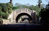
The Figueroa Street Tunnels are a set of four four-lane tunnel
s that carry northbound traffic on State Route 110 (the Arroyo Seco Parkway) through Elysian Park in Los Angeles, California
, United States
. From south to north, the four tunnels measure 755, 461, 130 and 405 feet (230, 141, 40 and 123 m) in length, 46.5 feet (14 m) in width, and 28.3 ft (8.6 m) in height. The north three tunnels opened in 1931 as a bypass to a section of North Broadway
; the southernmost (and longest) opened in 1935, connecting to Figueroa Street
downtown. Connections were added in 1937 to the Figueroa Street Viaduct, 1940 to the Arroyo Seco Parkway (known until 2010 as the Pasadena Freeway), and 1953 to the Four Level Interchange
. A new alignment for southbound traffic, passing through a cut to the west of the tunnels, opened in 1943.
Traffic through the tunnels is heavy at almost all times of day. At the north end of the tunnels is an interchange
with Interstate 5 (Golden State Freeway), in which the leftmost lane makes a hard left turn onto the offramp. There are also sharp exit and entrance ramps on the right side at Solano Avenue after the first tunnel.
Since the tunnels' incorporation into Arroyo Seco Parkway (now SR 110), Figueroa Street has been discontinuous. It merges into SR 110 at Alpine Street in Chinatown, south of the tunnels, and splits in Highland Park
, north of the Figueroa Street Viaduct over the Los Angeles River
.
on the congested 1911 North Broadway Bridge. The Dayton Avenue Bridge provided another crossing to the north, but the hills of Elysian Park prevented it from being connected to downtown. The north three of the four tunnels opened by November 1, 1931, connecting to North Broadway on the south via Solano Avenue and Riverside Drive on the north. Riverside Drive was an earlier high-speed road along the Los Angeles River
to Burbank, and also intersected the Dayton Avenue Bridge, which led to Dayton Avenue (now part of Figueroa Street) towards Pasadena. From opening, the tunnels carried two lanes in each direction, with a 5-foot (1.5 m) sidewalk on the side.
The fourth tunnel opened in 1935, continuing the route south and southwest to Figueroa Street at Alpine Street. (Bridges over Figueroa Street on Temple Street and First Street were built in 1940, further improving that entrance to downtown.) The Figueroa Street Viaduct opened in 1937, providing a wider and direct Los Angeles River
crossing than the Dayton Avenue Bridge. After passing over the river and San Fernando Road
, it tied into Dayton Avenue (Figueroa Street) south of Avenue 26. The Arroyo Seco Parkway opened in late 1940 as a freeway from the Viaduct to Pasadena. However, the six-lane parkway narrowed to four lanes at the viaduct and through the tunnels, and had a number of at-grade intersection
s on its way downtown.
The Southerly Extension of the Arroyo Seco Parkway supplemented the Figueroa Street Viaduct and Tunnels with a new southbound roadway to the west, and converted Figueroa Street to freeway standards south to Adobe Street. The new Los Angeles River Bridge left the existing road north of the original viaduct terminus at Figueroa Street, and crossed over the ramp to Figueroa Street, the Los Angeles River
, and the northbound exit to Riverside Drive (now a ramp to Interstate 5 north, although Riverside Drive is still accessible from this ramp). Through Elysian Park, it was built higher than the tunnels, with open-cuts through the ridges through which the older tunnels were built, and viaduct
s over the valleys between the ridges. South of the southernmost tunnel, the older road was widened and upgraded to freeway standards south to Adobe Street. This new road opened December 30, 1943. A further extension was completed on September 22, 1953 to the Four Level Interchange
with U.S. Route 101 (Santa Ana Freeway
and Hollywood Freeway
).
The tunnels (and Figueroa Street
north of them) were part of pre-1964 Legislative Route 165, defined in 1933. By 1942, U.S. Route 6, U.S. Route 66, U.S. Route 99 and State Route 11 were signed through them. US 66 continued along the Arroyo Seco Parkway, while US 6 and US 99 turned northwest on San Fernando Road
via Figueroa Street and Avenue 26, and SR 11 exited at Figueroa Street to run to Pasadena with U.S. Route 66 Alternate. US 99 moved to the new Golden State Freeway, bypassing the tunnels with Interstate 5, when it opened in 1962. US 6 and US 66 were removed from the Los Angeles area in the 1964 renumbering
, leaving only SR 11 through the tunnels (and on the Parkway after 1964). SR 11 became State Route 110 in 1981, when the Harbor Freeway section of it became Interstate 110
.
In April, 2008, retrofitting of the tunnel lighting was completed, replacing the tandem fluorescent lighting arrangement in place since 1964, with a more efficient lighting array.
In the movie Rumor Has It, three of the characters hold their breath while driving through the tunnels.
Tunnel
A tunnel is an underground passageway, completely enclosed except for openings for egress, commonly at each end.A tunnel may be for foot or vehicular road traffic, for rail traffic, or for a canal. Some tunnels are aqueducts to supply water for consumption or for hydroelectric stations or are sewers...
s that carry northbound traffic on State Route 110 (the Arroyo Seco Parkway) through Elysian Park in Los Angeles, California
Los Angeles, California
Los Angeles , with a population at the 2010 United States Census of 3,792,621, is the most populous city in California, USA and the second most populous in the United States, after New York City. It has an area of , and is located in Southern California...
, United States
United States
The United States of America is a federal constitutional republic comprising fifty states and a federal district...
. From south to north, the four tunnels measure 755, 461, 130 and 405 feet (230, 141, 40 and 123 m) in length, 46.5 feet (14 m) in width, and 28.3 ft (8.6 m) in height. The north three tunnels opened in 1931 as a bypass to a section of North Broadway
Broadway (Los Angeles)
Broadway is a major thoroughfare in Los Angeles, California, that runs from Lincoln Heights on the Eastside, through Chinatown, passing through Central Plaza and the Dragon Gate, the Los Angeles Civic Center, passing the Los Angeles Times building at First Street, and Broadway's historic commercial...
; the southernmost (and longest) opened in 1935, connecting to Figueroa Street
Figueroa Street
Figueroa Street is a street in Los Angeles County, California named for General José Figueroa , governor of Alta California from 1833 to 1835, who oversaw the secularization of the missions of California...
downtown. Connections were added in 1937 to the Figueroa Street Viaduct, 1940 to the Arroyo Seco Parkway (known until 2010 as the Pasadena Freeway), and 1953 to the Four Level Interchange
Four Level Interchange
The Four Level Interchange was the first stack interchange in the world. Completed in 1949 and fully opened in 1953 at the northern edge of downtown Los Angeles, California, USA, it connects U.S...
. A new alignment for southbound traffic, passing through a cut to the west of the tunnels, opened in 1943.
Traffic through the tunnels is heavy at almost all times of day. At the north end of the tunnels is an interchange
Interchange (road)
In the field of road transport, an interchange is a road junction that typically uses grade separation, and one or more ramps, to permit traffic on at least one highway to pass through the junction without directly crossing any other traffic stream. It differs from a standard intersection, at which...
with Interstate 5 (Golden State Freeway), in which the leftmost lane makes a hard left turn onto the offramp. There are also sharp exit and entrance ramps on the right side at Solano Avenue after the first tunnel.
Since the tunnels' incorporation into Arroyo Seco Parkway (now SR 110), Figueroa Street has been discontinuous. It merges into SR 110 at Alpine Street in Chinatown, south of the tunnels, and splits in Highland Park
Highland Park, Los Angeles, California
Highland Park is a neighborhood in Northeast Los Angeles.-Geography:Highland Park is located along the Arroyo Seco. It is situated within what was once Rancho San Rafael of the Spanish / Mexican era...
, north of the Figueroa Street Viaduct over the Los Angeles River
Los Angeles River
The Los Angeles River is a river that starts in the San Fernando Valley, in the Simi Hills and Santa Susana Mountains, and flows through Los Angeles County, California, from Canoga Park in the western end of the San Fernando Valley, nearly southeast to its mouth in Long Beach...
.
History
Prior to the construction of the tunnels, traffic between Los Angeles and Pasadena crossed the Los Angeles RiverLos Angeles River
The Los Angeles River is a river that starts in the San Fernando Valley, in the Simi Hills and Santa Susana Mountains, and flows through Los Angeles County, California, from Canoga Park in the western end of the San Fernando Valley, nearly southeast to its mouth in Long Beach...
on the congested 1911 North Broadway Bridge. The Dayton Avenue Bridge provided another crossing to the north, but the hills of Elysian Park prevented it from being connected to downtown. The north three of the four tunnels opened by November 1, 1931, connecting to North Broadway on the south via Solano Avenue and Riverside Drive on the north. Riverside Drive was an earlier high-speed road along the Los Angeles River
Los Angeles River
The Los Angeles River is a river that starts in the San Fernando Valley, in the Simi Hills and Santa Susana Mountains, and flows through Los Angeles County, California, from Canoga Park in the western end of the San Fernando Valley, nearly southeast to its mouth in Long Beach...
to Burbank, and also intersected the Dayton Avenue Bridge, which led to Dayton Avenue (now part of Figueroa Street) towards Pasadena. From opening, the tunnels carried two lanes in each direction, with a 5-foot (1.5 m) sidewalk on the side.
The fourth tunnel opened in 1935, continuing the route south and southwest to Figueroa Street at Alpine Street. (Bridges over Figueroa Street on Temple Street and First Street were built in 1940, further improving that entrance to downtown.) The Figueroa Street Viaduct opened in 1937, providing a wider and direct Los Angeles River
Los Angeles River
The Los Angeles River is a river that starts in the San Fernando Valley, in the Simi Hills and Santa Susana Mountains, and flows through Los Angeles County, California, from Canoga Park in the western end of the San Fernando Valley, nearly southeast to its mouth in Long Beach...
crossing than the Dayton Avenue Bridge. After passing over the river and San Fernando Road
San Fernando Road
San Fernando Road is a major street in the city and county of Los Angeles. It starts off in Castaic as The Old Road, passing through Santa Clarita and the Newhall Pass, whereupon its intersection with Sierra Highway near the junction of the Golden State and the Antelope Valley Freeways, it...
, it tied into Dayton Avenue (Figueroa Street) south of Avenue 26. The Arroyo Seco Parkway opened in late 1940 as a freeway from the Viaduct to Pasadena. However, the six-lane parkway narrowed to four lanes at the viaduct and through the tunnels, and had a number of at-grade intersection
At-grade intersection
An at-grade intersection is a junction at which two or more transport axes cross at the same level .-Traffic management:With areas of high or fast traffic, an at-grade intersection normally requires a traffic control device such as a stop sign, traffic light or railway signal to manage conflicting...
s on its way downtown.
The Southerly Extension of the Arroyo Seco Parkway supplemented the Figueroa Street Viaduct and Tunnels with a new southbound roadway to the west, and converted Figueroa Street to freeway standards south to Adobe Street. The new Los Angeles River Bridge left the existing road north of the original viaduct terminus at Figueroa Street, and crossed over the ramp to Figueroa Street, the Los Angeles River
Los Angeles River
The Los Angeles River is a river that starts in the San Fernando Valley, in the Simi Hills and Santa Susana Mountains, and flows through Los Angeles County, California, from Canoga Park in the western end of the San Fernando Valley, nearly southeast to its mouth in Long Beach...
, and the northbound exit to Riverside Drive (now a ramp to Interstate 5 north, although Riverside Drive is still accessible from this ramp). Through Elysian Park, it was built higher than the tunnels, with open-cuts through the ridges through which the older tunnels were built, and viaduct
Viaduct
A viaduct is a bridge composed of several small spans. The term viaduct is derived from the Latin via for road and ducere to lead something. However, the Ancient Romans did not use that term per se; it is a modern derivation from an analogy with aqueduct. Like the Roman aqueducts, many early...
s over the valleys between the ridges. South of the southernmost tunnel, the older road was widened and upgraded to freeway standards south to Adobe Street. This new road opened December 30, 1943. A further extension was completed on September 22, 1953 to the Four Level Interchange
Four Level Interchange
The Four Level Interchange was the first stack interchange in the world. Completed in 1949 and fully opened in 1953 at the northern edge of downtown Los Angeles, California, USA, it connects U.S...
with U.S. Route 101 (Santa Ana Freeway
Santa Ana Freeway
The Santa Ana Freeway is one of the principal freeways in Southern California, connecting Los Angeles and its southeastern suburbs including the freeway's namesake, the city of Santa Ana. The freeway begins at the Four Level Interchange in downtown Los Angeles, signed as U.S. Route 101...
and Hollywood Freeway
Hollywood Freeway
The Hollywood Freeway is one of the principal freeways of Los Angeles, California and one of the busiest in the United States. It is the principal route over the Cahuenga Pass, the primary shortcut between the Los Angeles Basin and the San Fernando Valley...
).
The tunnels (and Figueroa Street
Figueroa Street
Figueroa Street is a street in Los Angeles County, California named for General José Figueroa , governor of Alta California from 1833 to 1835, who oversaw the secularization of the missions of California...
north of them) were part of pre-1964 Legislative Route 165, defined in 1933. By 1942, U.S. Route 6, U.S. Route 66, U.S. Route 99 and State Route 11 were signed through them. US 66 continued along the Arroyo Seco Parkway, while US 6 and US 99 turned northwest on San Fernando Road
San Fernando Road
San Fernando Road is a major street in the city and county of Los Angeles. It starts off in Castaic as The Old Road, passing through Santa Clarita and the Newhall Pass, whereupon its intersection with Sierra Highway near the junction of the Golden State and the Antelope Valley Freeways, it...
via Figueroa Street and Avenue 26, and SR 11 exited at Figueroa Street to run to Pasadena with U.S. Route 66 Alternate. US 99 moved to the new Golden State Freeway, bypassing the tunnels with Interstate 5, when it opened in 1962. US 6 and US 66 were removed from the Los Angeles area in the 1964 renumbering
1964 state highway renumbering (California)
In 1963 and 1964, the California Division of Highways implemented a major renumbering of its state highways. The majority of sign routes — those marked for the public — kept their numbers; the main changes were to the legislative routes, which had their numbers changed to match the sign routes...
, leaving only SR 11 through the tunnels (and on the Parkway after 1964). SR 11 became State Route 110 in 1981, when the Harbor Freeway section of it became Interstate 110
Interstate 110 (California)
Route 110, consisting of two segments of State Route 110 joined by Interstate 110 , is a state highway in the Los Angeles area of the U.S. state of California, mostly built to freeway standards...
.
In April, 2008, retrofitting of the tunnel lighting was completed, replacing the tandem fluorescent lighting arrangement in place since 1964, with a more efficient lighting array.
In popular culture
In the 1971 Movie Duel where David Mann drives on the road.In the movie Rumor Has It, three of the characters hold their breath while driving through the tunnels.