
.gif)
Interstate 105 (California)
Encyclopedia
Interstate 105 is an Interstate Highway
in southern Los Angeles County, California
that runs east–west from near the Los Angeles International Airport
(LAX) to Norwalk
. It is officially known as the Glenn Anderson Freeway for the Democratic California politician
who advocated its construction. I-105 has also been referred to as the Century Freeway.
This route is part of the California Freeway and Expressway System
.
 The 105 begins at Sepulveda Boulevard
(State Route 1
) on the southern edge of Los Angeles International Airport
(LAX), adjacent to the city of El Segundo
. It proceeds generally eastward from there on, crossing the Los Angeles
and San Gabriel
Rivers before terminating just east of the San Gabriel River Freeway (Interstate 605) in western Norwalk
.
The freeway stops short of intersecting with the Santa Ana Freeway
(Interstate 5
), its parent interstate. Instead, the primary lanes of I-105 terminate at an at-grade intersection
with Studebaker Road.
Much of the length of the Century Freeway runs parallel to Imperial Highway
.
The Green Line (Los Angeles Metro) runs in the median of I-105 for the majority of its route from Redondo Beach to Norwalk.
, but did not open until 1993. Many factors contributed to the delay. The growth of the environmental
movement in the 1960s created resistance to new freeway construction. Fiscal difficulties brought about by the 1971 Sylmar earthquake
and the California tax revolt
of the late 1970s further hampered Caltrans' construction efforts.
However, the major source of resistance to the freeway's construction was community opposition
, and the side effects of these demands. By the early 1970s, most of the areas in the freeway's path (and thus slated to be demolished) were predominantly African-American. Resentment over previous freeway projects' effects on other black communities resulted in significant modifications to the original route. Most cities along the way, weary of the noise and visual blight created by elevated freeways, demanded that the route be built far below grade in a "trench." Also another source for resistance to the freeway's construction was that much of the areas along the I-105 path was going to be built in low income, high crime neighborhoods, which also delayed the freeway's construction until the crime in the areas went down. For his city at the center of the route, Lynwood
Councilman John D. Byork fought tirelessly for the completion of the Freeway, for which he was called the "Father of the Century Freeway". His efforts, markedly at the Southern California Association of Governments had assured that the homes demolished in Lynwood had resulted in better transportation for all in Los Angeles.
After construction began in the 1980s, failure to perform a full survey of the area's groundwater
deposits, combined with the 20–30 foot below-grade trench through the city of Downey
, resulted in buckling and cracking along the eastern portions of the route. At one point a large sinkhole opened in the Bellflower Boulevard on-ramp. This resulted in construction of an elaborate pump system along the freeway between the interchanges with I-710 and I-605.
Norwalk
, opposed to the freeway's proposed route through the center of the city, blocked the route from reaching its intended terminus at the (Interstate 5
); however, Caltrans had already decided to abandon that section due to the inability of the severely congested Santa Ana Freeway to accommodate any more traffic. The freeway eventually replaced Manchester Avenue and Firestone Boulevard (both State Route 42
), which were roads roughly parallel to the freeway.
The family home of Brian Wilson
and his brothers Dennis
and Carl
, founding members of the highly successful Beach Boys rock band, was demolished in the mid 1980s to make way for the freeway. A California Historic Landmark
marks the site of the former home.
Throughout the difficulties, Congressman Glenn M. Anderson
(D
-San Pedro) tirelessly advocated for the route's construction, touting its possibilities for congestion relief along Century
, Manchester, and Firestone Boulevards and the Imperial Highway
; it has succeeded in these tasks, as well as relieving pressure on the Santa Monica (I-10
) and San Diego
(I-405
) Freeways for travelers between Downtown Los Angeles
and LAX. After Anderson's death in 1994, Caltrans honored him by renaming the freeway in his honor. However, the route's original name, "Century Freeway", is still used on a number of maps.
Another important figure in the freeway's history was Harry Pregerson
, a United States federal judge
who presided over the lawsuit concerning the freeway's construction and chose to continue presiding over the case despite being promoted to a higher level court.
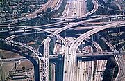
The interchange with Interstate 110 is named the Judge Harry Pregerson Interchange
in his honor.
The freeway was originally signed with El Segundo as its westbound control city
; however, in recent years, many of the El Segundo signs have been replaced and/or covered with "LAX Airport" signage due to the western terminus' proximity to Los Angeles International Airport
.
Shortly before opening, filmmakers had access to use the empty freeway for a number of weeks to film the 1994 motion picture Speed.
Previously, the I-105 designation has been used for U.S. Route 101 (the Santa Ana Freeway
) from I-5 (the Golden State Freeway) at the East Los Angeles Interchange
to the connection to I-10 (the San Bernardino Freeway
; this connection had been I-110
); it went back to U.S. 101 in 1968.
The entire route is in Los Angeles County
.
{| class=wikitable
!Location
!Postmile
!Exit
!Destinations
!Notes
|-
|El Segundo
|R0.00
|
|Imperial Highway
west
|Continuation beyond SR 1
|-
|rowspan=3|Los Angeles
|R0.50
|1
|
|Signed as exits 1B (south) and 1C (north) westbound
|-bgcolor=#ffdddd
|R1.24
|1D
|Nash Street – LAX Airport
|Westbound exit and eastbound entrance
|-bgcolor=#ffdddd
|R1.79
|2A
|La Cienega Boulevard
, Aviation Boulevard
|Westbound exit and eastbound entrance
|-
|rowspan=3|Hawthorne
|R2.11
|2B
|
|Signed as exit 2 eastbound; former SR 7
|-bgcolor=#ffdddd
|R3.05
|3
|Hawthorne Boulevard
|Westbound exit and eastbound entrance
|-
|R3.32
|3
|Prairie Avenue
|
|-
|Inglewood
|R4.71
|5
|Crenshaw Boulevard
|
|-
|rowspan="3"|Los Angeles
|R6.77
|7A
|Vermont Avenue
|
|-
|R7.39
|7B
|
|
|-
|R8.90
|9
|Central Avenue
|
|-
|Willowbrook
|R9.78
|10
|Wilmington Avenue
|
|-
|rowspan="2"|Lynwood
|R11.51
|12
|Long Beach Boulevard
|
|-
|R13.47
|13
|
|
|-
|rowspan=2|Paramount
|bgcolor=#ffdddd|R14.13
|bgcolor=#ffdddd|14
|bgcolor=#ffdddd|Garfield Avenue
|bgcolor=#ffdddd|Eastbound exit and westbound entrance
|-bgcolor=#ffdddd
|R14.65
|15
|Paramount Boulevard
|Westbound exit and eastbound entrance
|-
|Bellflower
|R15.76
|16
|
|
|-
|Downey
|R16.64
|17
|Bellflower Boulevard
|
|-
|rowspan="3"|Norwalk
|bgcolor=#ffdddd|R17.82
|bgcolor=#ffdddd|18
|bgcolor=#ffdddd|
|bgcolor=#ffdddd|Eastbound exit and westbound entrance; signed as exits 18A (south) and 18B (north)
|-
|R17.91
|
|Hoxie Avenue – Norwalk Metro Station
|HOV
only westbound
|-
|R18.15
|
|Studebaker Road
|At-grade intersection
(HOV
only westbound)
Interstate Highway System
The Dwight D. Eisenhower National System of Interstate and Defense Highways, , is a network of limited-access roads including freeways, highways, and expressways forming part of the National Highway System of the United States of America...
in southern Los Angeles County, California
Los Angeles County, California
Los Angeles County is a county in the U.S. state of California. As of 2010 U.S. Census, the county had a population of 9,818,605, making it the most populous county in the United States. Los Angeles County alone is more populous than 42 individual U.S. states...
that runs east–west from near the Los Angeles International Airport
Los Angeles International Airport
Los Angeles International Airport is the primary airport serving the Greater Los Angeles Area, the second-most populated metropolitan area in the United States. It is most often referred to by its IATA airport code LAX, with the letters pronounced individually...
(LAX) to Norwalk
Norwalk, California
Norwalk is a suburban city in Los Angeles County, California, United States. The population was 105,549 at the 2010 census, up from 103,298 at the 2000 census, making it the 58th most populous city in California and the 255th nationally....
. It is officially known as the Glenn Anderson Freeway for the Democratic California politician
Glenn M. Anderson
Glenn Malcolm Anderson was an American politician. He was the 37th Lieutenant Governor of California and later as congressman. He was a member of the Democratic Party....
who advocated its construction. I-105 has also been referred to as the Century Freeway.
This route is part of the California Freeway and Expressway System
California Freeway and Expressway System
The California Freeway and Expressway System is a system of existing or planned freeways and expressways in the U.S. state of California. It is defined by the Streets and Highways Code.-List of roads in the system:*State Route 1 *State Route 2...
.
Route description
Sepulveda Boulevard
Sepulveda Boulevard is a street in Los Angeles, California, which stretches some 42.8 miles from Rinaldi Street at the north end of the San Fernando Valley to the city limits of Hermosa Beach, where it "jumps" east and continues on to Long Beach. It generally runs north-south, passing underneath...
(State Route 1
California State Route 1
State Route 1 , more often called Highway 1, is a state highway that runs along much of the Pacific coast of the U.S. state of California. It is famous for running along some of the most beautiful coastlines in the world, leading to its designation as an All-American Road.Highway 1 does not run...
) on the southern edge of Los Angeles International Airport
Los Angeles International Airport
Los Angeles International Airport is the primary airport serving the Greater Los Angeles Area, the second-most populated metropolitan area in the United States. It is most often referred to by its IATA airport code LAX, with the letters pronounced individually...
(LAX), adjacent to the city of El Segundo
El Segundo, California
El Segundo is a city in Los Angeles County, California, United States. Located on the Santa Monica Bay, it was incorporated on January 18, 1917, and is one of the Beach Cities of Los Angeles County and part of the South Bay Cities Council of Governments...
. It proceeds generally eastward from there on, crossing the Los Angeles
Los Angeles River
The Los Angeles River is a river that starts in the San Fernando Valley, in the Simi Hills and Santa Susana Mountains, and flows through Los Angeles County, California, from Canoga Park in the western end of the San Fernando Valley, nearly southeast to its mouth in Long Beach...
and San Gabriel
San Gabriel River (California)
The San Gabriel River flows through southern Los Angeles County, California in the United States. Its main stem is about long, while its farthest tributaries extend almost altogether...
Rivers before terminating just east of the San Gabriel River Freeway (Interstate 605) in western Norwalk
Norwalk, California
Norwalk is a suburban city in Los Angeles County, California, United States. The population was 105,549 at the 2010 census, up from 103,298 at the 2000 census, making it the 58th most populous city in California and the 255th nationally....
.
The freeway stops short of intersecting with the Santa Ana Freeway
Santa Ana Freeway
The Santa Ana Freeway is one of the principal freeways in Southern California, connecting Los Angeles and its southeastern suburbs including the freeway's namesake, the city of Santa Ana. The freeway begins at the Four Level Interchange in downtown Los Angeles, signed as U.S. Route 101...
(Interstate 5
Interstate 5 in California
Interstate 5 is a major north–south route of the Interstate Highway System in the U.S. state of California. It begins at the Mexico – United States border at the San Ysidro crossing, goes north across the length of California and crosses into Oregon south of the Medford-Ashland metropolitan...
), its parent interstate. Instead, the primary lanes of I-105 terminate at an at-grade intersection
At-grade intersection
An at-grade intersection is a junction at which two or more transport axes cross at the same level .-Traffic management:With areas of high or fast traffic, an at-grade intersection normally requires a traffic control device such as a stop sign, traffic light or railway signal to manage conflicting...
with Studebaker Road.
Much of the length of the Century Freeway runs parallel to Imperial Highway
Imperial Highway
Imperial Highway is a road in Orange and Los Angeles counties in California. It begins at the Anaheim-Orange boundary and runs through several cities until it stops at Dockweiler State Beach in Los Angeles near the Los Angeles International Airport. For much of the way, Imperial Highway is signed...
.
The Green Line (Los Angeles Metro) runs in the median of I-105 for the majority of its route from Redondo Beach to Norwalk.
History
Interstate 105 was an integral part of Caltrans' 1960s master plan for the Southern California freeway systemSouthern California freeways
The Southern California freeways are a network of interconnected freeways in the Megaregion of Southern California with a population of 22 million. A comprehensive freeway plan was produced in 1947 and with construction beginning in the 1950s...
, but did not open until 1993. Many factors contributed to the delay. The growth of the environmental
Environmentalism
Environmentalism is a broad philosophy, ideology and social movement regarding concerns for environmental conservation and improvement of the health of the environment, particularly as the measure for this health seeks to incorporate the concerns of non-human elements...
movement in the 1960s created resistance to new freeway construction. Fiscal difficulties brought about by the 1971 Sylmar earthquake
Sylmar earthquake
The 1971 San Fernando earthquake struck the San Fernando Valley near Sylmar, California at 6:00:55 a.m. PST on February 9, 1971, with a magnitude of 6.6....
and the California tax revolt
Tax revolt
A tax revolt is a political struggle to repeal, limit, or roll back a tax.-1930s, The Great Depression:In the United States, the term "tax revolt" is sometimes used to refer to a series of anti-tax state initiative campaigns. The first significant wave of these campaigns was during the 1930s. The...
of the late 1970s further hampered Caltrans' construction efforts.
However, the major source of resistance to the freeway's construction was community opposition
Grassroots
A grassroots movement is one driven by the politics of a community. The term implies that the creation of the movement and the group supporting it are natural and spontaneous, highlighting the differences between this and a movement that is orchestrated by traditional power structures...
, and the side effects of these demands. By the early 1970s, most of the areas in the freeway's path (and thus slated to be demolished) were predominantly African-American. Resentment over previous freeway projects' effects on other black communities resulted in significant modifications to the original route. Most cities along the way, weary of the noise and visual blight created by elevated freeways, demanded that the route be built far below grade in a "trench." Also another source for resistance to the freeway's construction was that much of the areas along the I-105 path was going to be built in low income, high crime neighborhoods, which also delayed the freeway's construction until the crime in the areas went down. For his city at the center of the route, Lynwood
Lynwood, California
Lynwood is a city in Los Angeles County, California, United States of America. As of the 2010 census, the city had a total population of 69,772, down from 69,845 at the 2000 census. Lynwood is located near South Gate and Compton in the southern portion of the Los Angeles Basin. Incorporated in...
Councilman John D. Byork fought tirelessly for the completion of the Freeway, for which he was called the "Father of the Century Freeway". His efforts, markedly at the Southern California Association of Governments had assured that the homes demolished in Lynwood had resulted in better transportation for all in Los Angeles.
After construction began in the 1980s, failure to perform a full survey of the area's groundwater
Groundwater
Groundwater is water located beneath the ground surface in soil pore spaces and in the fractures of rock formations. A unit of rock or an unconsolidated deposit is called an aquifer when it can yield a usable quantity of water. The depth at which soil pore spaces or fractures and voids in rock...
deposits, combined with the 20–30 foot below-grade trench through the city of Downey
Downey, California
Downey is a city located in southeast Los Angeles County, California, United States, southeast of downtown Los Angeles. The city is best known as the birthplace of the Apollo space program, and is the city where folk singer Karen Carpenter lived and died...
, resulted in buckling and cracking along the eastern portions of the route. At one point a large sinkhole opened in the Bellflower Boulevard on-ramp. This resulted in construction of an elaborate pump system along the freeway between the interchanges with I-710 and I-605.
Norwalk
Norwalk, California
Norwalk is a suburban city in Los Angeles County, California, United States. The population was 105,549 at the 2010 census, up from 103,298 at the 2000 census, making it the 58th most populous city in California and the 255th nationally....
, opposed to the freeway's proposed route through the center of the city, blocked the route from reaching its intended terminus at the (Interstate 5
Interstate 5 in California
Interstate 5 is a major north–south route of the Interstate Highway System in the U.S. state of California. It begins at the Mexico – United States border at the San Ysidro crossing, goes north across the length of California and crosses into Oregon south of the Medford-Ashland metropolitan...
); however, Caltrans had already decided to abandon that section due to the inability of the severely congested Santa Ana Freeway to accommodate any more traffic. The freeway eventually replaced Manchester Avenue and Firestone Boulevard (both State Route 42
State Route 42 (California)
State Route 42 was a state highway in southern region of the U.S. State of California, running along Manchester Avenue, Manchester Boulevard and Firestone Boulevard in Los Angeles and the cities south of it. After 1968, it ran from State Route 1 west of Inglewood east to Interstate 5 in Norwalk...
), which were roads roughly parallel to the freeway.
The family home of Brian Wilson
Brian Wilson
Brian Douglas Wilson is an American musician, best known as the leader and chief songwriter of the group The Beach Boys. Within the band, Wilson played bass and keyboards, also providing part-time lead vocals and, more often, backing vocals, harmonizing in falsetto with the group...
and his brothers Dennis
Dennis Wilson
Dennis Carl Wilson was an American rock and roll musician best known as a founding member and the drummer of The Beach Boys. He was a member of the group from its formation until his death in 1983...
and Carl
Carl Wilson
Carl Dean Wilson was an American rock and roll singer and guitarist, best known as a founding member, lead guitarist and sometime lead vocalist of The Beach Boys...
, founding members of the highly successful Beach Boys rock band, was demolished in the mid 1980s to make way for the freeway. A California Historic Landmark
Beach Boys Historic Landmark
The Beach Boys Historic Landmark commemorates the site of the childhood home of Brian, Carl, and Dennis Wilson of the Beach Boys. The monument, located at 3701 W...
marks the site of the former home.
Throughout the difficulties, Congressman Glenn M. Anderson
Glenn M. Anderson
Glenn Malcolm Anderson was an American politician. He was the 37th Lieutenant Governor of California and later as congressman. He was a member of the Democratic Party....
(D
Democratic Party (United States)
The Democratic Party is one of two major contemporary political parties in the United States, along with the Republican Party. The party's socially liberal and progressive platform is largely considered center-left in the U.S. political spectrum. The party has the lengthiest record of continuous...
-San Pedro) tirelessly advocated for the route's construction, touting its possibilities for congestion relief along Century
Century Boulevard
Century Boulevard is a street in South Los Angeles, extending from Wilmington Avenue in the east to the passenger terminals at Los Angeles International Airport in the west ....
, Manchester, and Firestone Boulevards and the Imperial Highway
Imperial Highway
Imperial Highway is a road in Orange and Los Angeles counties in California. It begins at the Anaheim-Orange boundary and runs through several cities until it stops at Dockweiler State Beach in Los Angeles near the Los Angeles International Airport. For much of the way, Imperial Highway is signed...
; it has succeeded in these tasks, as well as relieving pressure on the Santa Monica (I-10
Interstate 10 in California
Interstate 10 , the major east–west Interstate Highway in the Southern United States, runs in the U.S. state of California east from Santa Monica, on the Pacific Ocean, through Los Angeles and San Bernardino to the border with Arizona...
) and San Diego
Interstate 405 (California)
Interstate 405 is a major north–south Interstate Highway in Southern California. It is a bypass of Interstate 5, running along the western areas of the Greater Los Angeles Area from Irvine in the south to near San Fernando in the north...
(I-405
Interstate 405 (California)
Interstate 405 is a major north–south Interstate Highway in Southern California. It is a bypass of Interstate 5, running along the western areas of the Greater Los Angeles Area from Irvine in the south to near San Fernando in the north...
) Freeways for travelers between Downtown Los Angeles
Downtown Los Angeles
Downtown Los Angeles is the central business district of Los Angeles, California, United States, located close to the geographic center of the metropolitan area...
and LAX. After Anderson's death in 1994, Caltrans honored him by renaming the freeway in his honor. However, the route's original name, "Century Freeway", is still used on a number of maps.
Another important figure in the freeway's history was Harry Pregerson
Harry Pregerson
Harry Pregerson serves as a judge on the United States Court of Appeals for the Ninth Circuit. He was appointed to the Ninth Circuit in 1979 by President Jimmy Carter...
, a United States federal judge
United States federal judge
In the United States, the title of federal judge usually means a judge appointed by the President of the United States and confirmed by the United States Senate in accordance with Article II of the United States Constitution....
who presided over the lawsuit concerning the freeway's construction and chose to continue presiding over the case despite being promoted to a higher level court.
The interchange with Interstate 110 is named the Judge Harry Pregerson Interchange
Judge Harry Pregerson Interchange
The Judge Harry Pregerson Interchange is a stack interchange near the Athens and Watts communities of Los Angeles, California. It is the interchange of the following routes:...
in his honor.
The freeway was originally signed with El Segundo as its westbound control city
Control city
A control city is a city or locality posted on a traffic sign indicating forward destinations on a certain route. These destinations aid motorists using the highway system to reach destinations along the various routes...
; however, in recent years, many of the El Segundo signs have been replaced and/or covered with "LAX Airport" signage due to the western terminus' proximity to Los Angeles International Airport
Los Angeles International Airport
Los Angeles International Airport is the primary airport serving the Greater Los Angeles Area, the second-most populated metropolitan area in the United States. It is most often referred to by its IATA airport code LAX, with the letters pronounced individually...
.
Shortly before opening, filmmakers had access to use the empty freeway for a number of weeks to film the 1994 motion picture Speed.
Previously, the I-105 designation has been used for U.S. Route 101 (the Santa Ana Freeway
Santa Ana Freeway
The Santa Ana Freeway is one of the principal freeways in Southern California, connecting Los Angeles and its southeastern suburbs including the freeway's namesake, the city of Santa Ana. The freeway begins at the Four Level Interchange in downtown Los Angeles, signed as U.S. Route 101...
) from I-5 (the Golden State Freeway) at the East Los Angeles Interchange
East Los Angeles Interchange
The East Los Angeles Interchange complex is the busiest freeway interchange in the world, with its southern portion handling over 550,000 vehicles per day . The northern portion, called the San Bernardino Split, is often considered a separate interchange. The interchange was named the Eugene A....
to the connection to I-10 (the San Bernardino Freeway
San Bernardino Freeway
The San Bernardino Freeway, formerly known as the Ramona Freeway is a freeway in Los Angeles and Orange Counties in the southern part of the U.S. state of California. It refers to the following two segments:...
; this connection had been I-110
Interstate 110 (California)
Route 110, consisting of two segments of State Route 110 joined by Interstate 110 , is a state highway in the Los Angeles area of the U.S. state of California, mostly built to freeway standards...
); it went back to U.S. 101 in 1968.
Exit list
- Note: Except where prefixed with a letter, postmiles were measured in 1964, based on the alignment as it existed at that time, and do not necessarily reflect current mileage.
The entire route is in Los Angeles County
Los Angeles County, California
Los Angeles County is a county in the U.S. state of California. As of 2010 U.S. Census, the county had a population of 9,818,605, making it the most populous county in the United States. Los Angeles County alone is more populous than 42 individual U.S. states...
.
{| class=wikitable
!Location
!Postmile
!Exit
Exit number
An exit number is a number assigned to a road junction, usually an exit from a freeway. It is usually marked on the same sign as the destinations of the exit, as well as a sign in the gore....
!Destinations
!Notes
|-
|El Segundo
El Segundo, California
El Segundo is a city in Los Angeles County, California, United States. Located on the Santa Monica Bay, it was incorporated on January 18, 1917, and is one of the Beach Cities of Los Angeles County and part of the South Bay Cities Council of Governments...
|R0.00
|
|Imperial Highway
Imperial Highway
Imperial Highway is a road in Orange and Los Angeles counties in California. It begins at the Anaheim-Orange boundary and runs through several cities until it stops at Dockweiler State Beach in Los Angeles near the Los Angeles International Airport. For much of the way, Imperial Highway is signed...
west
|Continuation beyond SR 1
|-
|rowspan=3|Los Angeles
Los Angeles, California
Los Angeles , with a population at the 2010 United States Census of 3,792,621, is the most populous city in California, USA and the second most populous in the United States, after New York City. It has an area of , and is located in Southern California...
|R0.50
|1
|
|Signed as exits 1B (south) and 1C (north) westbound
|-bgcolor=#ffdddd
|R1.24
|1D
|Nash Street – LAX Airport
|Westbound exit and eastbound entrance
|-bgcolor=#ffdddd
|R1.79
|2A
|La Cienega Boulevard
La Cienega Boulevard
La Cienega Boulevard is a major, well-known north–south arterial road that runs between El Segundo Boulevard in El Segundo, California on the south and the Sunset Strip/Sunset Boulevard in West Hollywood....
, Aviation Boulevard
|Westbound exit and eastbound entrance
|-
|rowspan=3|Hawthorne
Hawthorne, California
Hawthorne is a city in southwestern Los Angeles County, California. The city at the 2010 census had a population of 84,293, up from 84,112 at the 2000 census.-Geography:...
|R2.11
|2B
|
|Signed as exit 2 eastbound; former SR 7
|-bgcolor=#ffdddd
|R3.05
|3
|Hawthorne Boulevard
|Westbound exit and eastbound entrance
|-
|R3.32
|3
|Prairie Avenue
|
|-
|Inglewood
Inglewood, California
Inglewood is a city in southwestern Los Angeles County, California, southwest of downtown Los Angeles. It was incorporated on February 14, 1908. Its population stood at 109,673 as of the 2010 Census...
|R4.71
|5
|Crenshaw Boulevard
|
|-
|rowspan="3"|Los Angeles
Los Angeles, California
Los Angeles , with a population at the 2010 United States Census of 3,792,621, is the most populous city in California, USA and the second most populous in the United States, after New York City. It has an area of , and is located in Southern California...
|R6.77
|7A
|Vermont Avenue
Vermont Avenue
Vermont Avenue is one of the longest running north/south streets in Los Angeles, California with a length of about . Located just west of the Harbor Freeway for the major portion south of Downtown Los Angeles, it starts in Griffith Park at the Greek Theatre in the Los Feliz neighborhood as a...
|
|-
|R7.39
|7B
|
|
|-
|R8.90
|9
|Central Avenue
Central Avenue (Los Angeles)
Central Avenue is a major north-south thoroughfare in the central portion of the Los Angeles, California metropolitan area. Located just to the west of the Alameda Corridor, it runs from the eastern end of the Los Angeles Civic Center south, ending at Del Amo Boulevard in Carson...
|
|-
|Willowbrook
Willowbrook, California
Willowbrook is an unincorporated community and census-designated place in Los Angeles County, California. The population was 35,983 at the 2010 census, up from 34,138 at the 2000 census. The community is located near the southeast edge of, and is often considered part of, South Los Angeles...
|R9.78
|10
|Wilmington Avenue
|
|-
|rowspan="2"|Lynwood
Lynwood, California
Lynwood is a city in Los Angeles County, California, United States of America. As of the 2010 census, the city had a total population of 69,772, down from 69,845 at the 2000 census. Lynwood is located near South Gate and Compton in the southern portion of the Los Angeles Basin. Incorporated in...
|R11.51
|12
|Long Beach Boulevard
Long Beach Boulevard
Long Beach Boulevard is a north south thoroughfare in Los Angeles County.-Geography:Long Beach Boulevard starts off as a continuation of Pacific Boulevard south of Cudahy Avenue in South Gate. Long Beach Boulevard passes through South Gate, Lynwood, Compton and Long Beach...
|
|-
|R13.47
|13
|
|
|-
|rowspan=2|Paramount
Paramount, California
Paramount is a city in Los Angeles County, California, United States. According to the 2010 census, the city had a total population of 54,098 down from 55,266 at the 2000 census...
|bgcolor=#ffdddd|R14.13
|bgcolor=#ffdddd|14
|bgcolor=#ffdddd|Garfield Avenue
Garfield Avenue (Los Angeles County)
Garfield Avenue is a major north-south street in Los Angeles County, California, US.The avenue lies between Atlantic Boulevard and Rosemead/Lakewood Boulevard. It begins as Garfield Avenue as a minor street north of Grevelia Street in South Pasadena...
|bgcolor=#ffdddd|Eastbound exit and westbound entrance
|-bgcolor=#ffdddd
|R14.65
|15
|Paramount Boulevard
|Westbound exit and eastbound entrance
|-
|Bellflower
Bellflower, California
Bellflower is a city in Los Angeles County, California, and is a suburb of Los Angeles. It was incorporated on September 3, 1957. As of the 2010 census, the city had a total population of 76,616, up from 72,878 at the 2000 census....
|R15.76
|16
|
|
|-
|Downey
Downey, California
Downey is a city located in southeast Los Angeles County, California, United States, southeast of downtown Los Angeles. The city is best known as the birthplace of the Apollo space program, and is the city where folk singer Karen Carpenter lived and died...
|R16.64
|17
|Bellflower Boulevard
|
|-
|rowspan="3"|Norwalk
Norwalk, California
Norwalk is a suburban city in Los Angeles County, California, United States. The population was 105,549 at the 2010 census, up from 103,298 at the 2000 census, making it the 58th most populous city in California and the 255th nationally....
|bgcolor=#ffdddd|R17.82
|bgcolor=#ffdddd|18
|bgcolor=#ffdddd|
|bgcolor=#ffdddd|Eastbound exit and westbound entrance; signed as exits 18A (south) and 18B (north)
|-
|R17.91
|
|Hoxie Avenue – Norwalk Metro Station
|HOV
High-occupancy vehicle lane
In transportation engineering and transportation planning, a high-occupancy vehicle lane is a lane reserved for vehicles with a driver and one or more passengers...
only westbound
|-
|R18.15
|
|Studebaker Road
|At-grade intersection
At-grade intersection
An at-grade intersection is a junction at which two or more transport axes cross at the same level .-Traffic management:With areas of high or fast traffic, an at-grade intersection normally requires a traffic control device such as a stop sign, traffic light or railway signal to manage conflicting...
(HOV
High-occupancy vehicle lane
In transportation engineering and transportation planning, a high-occupancy vehicle lane is a lane reserved for vehicles with a driver and one or more passengers...
only westbound)