

Roman military frontiers and fortifications
Encyclopedia
Grand strategy
Grand strategy comprises the "purposeful employment of all instruments of power available to a security community". Military historian B. H. Liddell Hart says about grand strategy:...
of territorial defense in the Roman Empire
Roman Empire
The Roman Empire was the post-Republican period of the ancient Roman civilization, characterised by an autocratic form of government and large territorial holdings in Europe and around the Mediterranean....
. By the early 2nd century, the Roman Empire
Roman Empire
The Roman Empire was the post-Republican period of the ancient Roman civilization, characterised by an autocratic form of government and large territorial holdings in Europe and around the Mediterranean....
had reached the peak of its territorial expansion and rather than constantly expanding their borders as earlier in the Empire and Republic, the Romans solidified their position by fortifying their strategic position with a series of fortifications and established lines of defense. Historian Adrian Goldsworthy
Adrian Goldsworthy
Adrian Keith Goldsworthy is a British historian and author who specialises in ancient Roman history.-Biography:Goldsworthy attended Westbourne School, Penarth...
argues that the Romans had reached the natural limits which their military traditions afforded them conquest over and that beyond the borders as fortified in the early to mid Empire lay peoples whose military traditions made them militarily unconquerable by the Romans. In particular, Goldsworthy argues that the cavalry-based warfare of the Parthians, Persians and Huns
Huns
The Huns were a group of nomadic people who, appearing from east of the Volga River, migrated into Europe c. AD 370 and established the vast Hunnic Empire there. Since de Guignes linked them with the Xiongnu, who had been northern neighbours of China 300 years prior to the emergence of the Huns,...
presented an insurmountable challenge to the expansion of Rome's infantry-based armies.
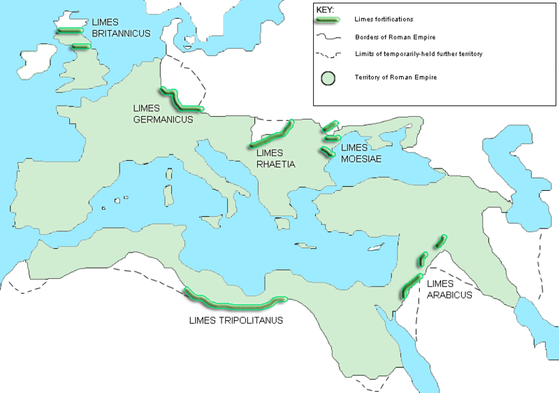
Nature of the fortifications
The borders of the Roman EmpireRoman Empire
The Roman Empire was the post-Republican period of the ancient Roman civilization, characterised by an autocratic form of government and large territorial holdings in Europe and around the Mediterranean....
, which fluctuated throughout the empire's history, were a combination of natural frontiers (the Rhine and Danube rivers to the north and east, the Atlantic to the West, and deserts to the South) and man-made fortifications which separated the lands of the empire from the "barbarian
Barbarian
Barbarian and savage are terms used to refer to a person who is perceived to be uncivilized. The word is often used either in a general reference to a member of a nation or ethnos, typically a tribal society as seen by an urban civilization either viewed as inferior, or admired as a noble savage...
" lands beyond.
Individual fortifications had been constructed by the Roman military from as early as the building of Rome's first civic walls in the 6th or 7th century BC. However, systematic construction of fortifications around the periphery of the empire on a strategic scale began around 40
40s
-Significant people:* Gaius Caesar Germanicus/Caligula .* Claudius, Roman Emperor .* Paul of Tarsus, Christian evangelist...
under Emperor Caligula
Caligula
Caligula , also known as Gaius, was Roman Emperor from 37 AD to 41 AD. Caligula was a member of the house of rulers conventionally known as the Julio-Claudian dynasty. Caligula's father Germanicus, the nephew and adopted son of Emperor Tiberius, was a very successful general and one of Rome's most...
. The coherent construction of these fortifications on a strategic scale (i.e. to protect the empire as a whole rather than fortifying individual settlements) are known as the limes
Limes
A limes was a border defense or delimiting system of Ancient Rome. It marked the boundaries of the Roman Empire.The Latin noun limes had a number of different meanings: a path or balk delimiting fields, a boundary line or marker, any road or path, any channel, such as a stream channel, or any...
, and continued until around 270.
The limes consisted of fortresses for legions or vexillations (e.g. Segedunum) as well as a system of roads for the rapid transit of troops and, in some places, extensive walls. Perhaps the most famous example of these is Hadrian's Wall
Hadrian's Wall
Hadrian's Wall was a defensive fortification in Roman Britain. Begun in AD 122, during the rule of emperor Hadrian, it was the first of two fortifications built across Great Britain, the second being the Antonine Wall, lesser known of the two because its physical remains are less evident today.The...
in Great Britain
Great Britain
Great Britain or Britain is an island situated to the northwest of Continental Europe. It is the ninth largest island in the world, and the largest European island, as well as the largest of the British Isles...
, which was built across the entire width of the island to protect from attack from tribes located in modern-day Scotland. The so-called Limes Britannicus is perhaps the best example of the ultimate limes - like the Great Wall of China
Great Wall of China
The Great Wall of China is a series of stone and earthen fortifications in northern China, built originally to protect the northern borders of the Chinese Empire against intrusions by various nomadic groups...
, it was an attempt to construct a continuous man-made fortification along the length of an entire border, a massive undertaking. However, it is not correct to interpret other limes in the same way or to view the limes as an impenetrable barrier. Other limes would not have had a continuous man-made fortification for the entirety of their length. In places, a river, desert or natural outcropping of rock could provide the same effect for zero outlay. Also, fortifications as impressive as Hadrian's Wall
Hadrian's Wall
Hadrian's Wall was a defensive fortification in Roman Britain. Begun in AD 122, during the rule of emperor Hadrian, it was the first of two fortifications built across Great Britain, the second being the Antonine Wall, lesser known of the two because its physical remains are less evident today.The...
were not unbreachable: with milecastles some distance apart and patrols infrequent, small enemy forces would have been able to penetrate the defenses easily for small-scale raiding. However, a raiding party would be forced to fight its way through one of the well-defended gates, abandon its loot, such as cattle, thus negating the whole purpose of the raid or be trapped against the wall by the responding legions. Additionally, a large army would have been able to force a crossing of the limes using siege equipment. The value of the limes lay not in its absolute impenetrability but, as S. Thomas Parker argues, in its hindrance to the enemy: granting a delay or warning that could be used to summon concentrated Roman forces to the site. The limes are therefore perhaps better seen as an instrument allowing a greater economy of force in defense of a border than otherwise would be necessary to provide the same level of defense.
After 270, the maintenance of an impenetrable solid frontier was abandoned by Constantine I
Constantine I
Constantine the Great , also known as Constantine I or Saint Constantine, was Roman Emperor from 306 to 337. Well known for being the first Roman emperor to convert to Christianity, Constantine and co-Emperor Licinius issued the Edict of Milan in 313, which proclaimed religious tolerance of all...
in favor of a policy, whether deliberate or forced by circumstance, of "defense in depth". This called for the maintenance of a softer, deeper perimeter area of defense, with concentrated hard points throughout its depth. The idea was that any invading force of a sufficient size could penetrate the initial perimeter but in doing so with any element of surprise or rapid movement would be forced to leave several defended hard points (fortresses) to its rear, hampering its lines of supply and communications, and threatening surrounding of the force.
In the very late Empire the frontiers became even more elastic, with little effort expended in maintaining frontier defense. Instead, armies were concentrated near the heart of the empire, and enemies allowed to penetrate in cases as far inwards as the Italian peninsula before being met in battle.
Britannia
After conquering much of the modern landmass of Great BritainGreat Britain
Great Britain or Britain is an island situated to the northwest of Continental Europe. It is the ninth largest island in the world, and the largest European island, as well as the largest of the British Isles...
, the Romans halted their northern expansion at the southern fringe of Caledonia
Caledonia
Caledonia is the Latinised form and name given by the Romans to the land in today's Scotland north of their province of Britannia, beyond the frontier of their empire...
, what is now central Scotland
Central Belt
The Central Belt of Scotland is a common term used to describe the area of highest population density within Scotland. Despite the name, it is not geographically central but is nevertheless situated at the 'waist' of Scotland on a conventional map and the term 'central' is used in many local...
. Although capable of conquering the entirety of Scotland should it have been desirable, the Romans deemed the task not to be worthwhile due to the paucity of its resources and the relative infertility of its land. However, this presented a problem for the Romans in that it left them with a border shared with a people who made repeated raids and insurrections against them. Unlike other borders throughout the empire, there was no natural border to fall back on such as desert or wide river that crossed the whole peninsula, so instead a series of defenses were built in southern to mid-Scotland in order to protect the province of Britannia from the Caledonians and later the Picts.

Gask Ridge
The Gask Ridge is the modern name given to an early series of fortifications, built by the Romans in Scotland, close to the Highland Line.-Name:...
in mid-Scotland may well be Rome's earliest fortified land frontier. Constructed in the 70s or 80s, it was superseded by the later Hadrian's Wall
Hadrian's Wall
Hadrian's Wall was a defensive fortification in Roman Britain. Begun in AD 122, during the rule of emperor Hadrian, it was the first of two fortifications built across Great Britain, the second being the Antonine Wall, lesser known of the two because its physical remains are less evident today.The...
forty years later and then the final Antonine Wall
Antonine Wall
The Antonine Wall is a stone and turf fortification built by the Romans across what is now the Central Belt of Scotland, between the Firth of Forth and the Firth of Clyde. Representing the northernmost frontier barrier of the Roman Empire, it spanned approximately 39 miles and was about ten feet ...
twenty years after that. Rather than representing a series of consecutive advancements, the border should be seen as fluctuating - the Antonine Wall for example was built between 142 and 144, abandoned by 164 and briefly re-occupied in 208.
Although records are scarce, there are indications that the border fluctuated between the various fortifications depending on the local strength of the military. There is archaeological evidence for widespread burning of fortifications, but it is disputed whether this represents fortifications falling to attack or part of the normal process of the Roman military to destroy their own fortified camps on abandonment so as not to furnish the enemy with a fortified base at their expense.
These northern fortifications are sometimes styled the Limes Britannicus. The average garrison of the wall fortifications is thought to have been around 10,000 men. Along with a continuous wall (except in the case of Gask Ridge), there existed a metaled road immediately behind the wall for transport of troops. Along the wall there existed a few large forts for legions
Roman legion
A Roman legion normally indicates the basic ancient Roman army unit recruited specifically from Roman citizens. The organization of legions varied greatly over time but they were typically composed of perhaps 5,000 soldiers, divided into maniples and later into "cohorts"...
or vexillations, as well as a series of milecastle
Milecastle
A milecastle was a small fort , a rectangular fortification built during the period of the Roman Empire. They were placed at intervals of approximately one Roman mile along several major frontiers, for example Hadrian's Wall in Great Britain , hence the name.Along Hadrian's Wall, milecastles were...
s - effectively watchtowers that were unable to defend a stretch of wall against anything but low-scale raiding but were able to signal attack to legionary forts by means of fire signals atop the towers.
In the later Empire, Roman Britannia found itself increasingly vulnerable to external aggression, in parallel to attacks felt across the length of the Empire's borders. However, since Britannia shared no land bridge with continental Europe, the method of attack and thus methods of defense varied from the imperial standard. A series of naval forts was built along the south east coast, initially to combat piracy but later to protect from raiding and the threat of invasion from Saxons that eventually led to the Saxon occupation of Lowland Britain by 600
600
Year 600 was a leap year starting on Friday of the Julian calendar. The denomination 600 for this year has been used since the early medieval period, when the Anno Domini calendar era became the prevalent method in Europe for naming years.- Europe :* Smallpox arrives in Europe for the first...
and is reflected in the name of the fortification system: the Saxon Shore
Saxon Shore
Saxon Shore could refer to one of the following:* Saxon Shore, a military command of the Late Roman Empire, encompassing southern Britain and the coasts of northern France...
, which extended to the northern coasts of France. Each shore fort both protected against direct attack and also sheltered a small naval sub-fleet of vessels that could patrol the coast against pirates and raiders.
Continental Europe
.jpg)
Danube
The Danube is a river in the Central Europe and the Europe's second longest river after the Volga. It is classified as an international waterway....
. Nevertheless those were not always the final border lines: the province of Dacia
Dacia
In ancient geography, especially in Roman sources, Dacia was the land inhabited by the Dacians or Getae as they were known by the Greeks—the branch of the Thracians north of the Haemus range...
, modern Romania
Romania
Romania is a country located at the crossroads of Central and Southeastern Europe, on the Lower Danube, within and outside the Carpathian arch, bordering on the Black Sea...
, was completely north of the Danube, and the province of Germania Magna, which should not be confused with Germania Inferior
Germania Inferior
Germania Inferior was a Roman province located on the left bank of the Rhine, in today's Luxembourg, southern Netherlands, parts of Belgium, and North Rhine-Westphalia left of the Rhine....
and Germania Superior
Germania Superior
Germania Superior , so called for the reason that it lay upstream of Germania Inferior, was a province of the Roman Empire. It comprised an area of western Switzerland, the French Jura and Alsace regions, and southwestern Germany...
, was the land between the Rhine, the Danube and the Elbe
Elbe
The Elbe is one of the major rivers of Central Europe. It rises in the Krkonoše Mountains of the northwestern Czech Republic before traversing much of Bohemia , then Germany and flowing into the North Sea at Cuxhaven, 110 km northwest of Hamburg...
(Although this province was lost three years after its creation as a result of the Battle of Teutoburg Forest). The limes that ran across the line of the Rhine-Danube was known as the Limes Germanicus
Limes Germanicus
The Limes Germanicus was a line of frontier fortifications that bounded the ancient Roman provinces of Germania Inferior, Germania Superior and Raetia, dividing the Roman Empire and the unsubdued Germanic tribes from the years 83 to about 260 AD...
. It consisted of:
- The Lower (Northern) Germanic Limes, which extended from the North Sea at Katwijk in the Netherlands along the Rhine;
- The Upper Germanic Limes (just to be confusing, also called the Rhaetian Limes or simply "the Limes") started from the Rhine at Rheinbrohl (Neuwied (district)) across the Taunus mountains to the river Main (East of Hanau), then along the Main to Miltenberg, and from Osterburken (Neckar-Odenwald-Kreis) south to Lorch (Ostalbkreis) in a nearly perfect straight line of more than 70 km;
- The proper Rhaetian Limes extended east from Lorch to Eining (close to Kelheim) on the Danube. The total length was 568 km (352.9 mi). It included at least 60 castles and 900 watchtowers.
Eastern borders
The eastern borders changed many times, of which the most enduring was the EuphratesEuphrates
The Euphrates is the longest and one of the most historically important rivers of Western Asia. Together with the Tigris, it is one of the two defining rivers of Mesopotamia...
river, bordering the Parthian Empire
Parthian Empire
The Parthian Empire , also known as the Arsacid Empire , was a major Iranian political and cultural power in ancient Persia...
in modern Iran
Iran
Iran , officially the Islamic Republic of Iran , is a country in Southern and Western Asia. The name "Iran" has been in use natively since the Sassanian era and came into use internationally in 1935, before which the country was known to the Western world as Persia...
and western Iraq
Iraq
Iraq ; officially the Republic of Iraq is a country in Western Asia spanning most of the northwestern end of the Zagros mountain range, the eastern part of the Syrian Desert and the northern part of the Arabian Desert....
. Rome advanced beyond the Euphrates for a time upon defeating their rivals, the Parthia
Parthia
Parthia is a region of north-eastern Iran, best known for having been the political and cultural base of the Arsacid dynasty, rulers of the Parthian Empire....
ns in 116 AD, when Trajan
Trajan
Trajan , was Roman Emperor from 98 to 117 AD. Born into a non-patrician family in the province of Hispania Baetica, in Spain Trajan rose to prominence during the reign of emperor Domitian. Serving as a legatus legionis in Hispania Tarraconensis, in Spain, in 89 Trajan supported the emperor against...
captured Ctesiphon
Ctesiphon
Ctesiphon, the imperial capital of the Parthian Arsacids and of the Persian Sassanids, was one of the great cities of ancient Mesopotamia.The ruins of the city are located on the east bank of the Tigris, across the river from the Hellenistic city of Seleucia...
, and established new provinces in Assyria
Assyria
Assyria was a Semitic Akkadian kingdom, extant as a nation state from the mid–23rd century BC to 608 BC centred on the Upper Tigris river, in northern Mesopotamia , that came to rule regional empires a number of times through history. It was named for its original capital, the ancient city of Assur...
and Babylonia
Babylonia
Babylonia was an ancient cultural region in central-southern Mesopotamia , with Babylon as its capital. Babylonia emerged as a major power when Hammurabi Babylonia was an ancient cultural region in central-southern Mesopotamia (present-day Iraq), with Babylon as its capital. Babylonia emerged as...
. Later that year he took the Parthian capital, Susa
Susa
Susa was an ancient city of the Elamite, Persian and Parthian empires of Iran. It is located in the lower Zagros Mountains about east of the Tigris River, between the Karkheh and Dez Rivers....
, deposed the Parthian King Osroes I. However, the Romans did not Romanize
Romanization
In linguistics, romanization or latinization is the representation of a written word or spoken speech with the Roman script, or a system for doing so, where the original word or language uses a different writing system . Methods of romanization include transliteration, for representing written...
the entire Parthian Empire, leaving Parthamaspates as a puppet king
Puppet state
A puppet state is a nominal sovereign of a state who is de facto controlled by a foreign power. The term refers to a government controlled by the government of another country like a puppeteer controls the strings of a marionette...
on the throne to rule over former Parthian lands with the exclusion of modern Iraq, which became Assyria
Assyria (Roman province)
Assyria or Assyria Provincia was a roman province that lasted only two years .-History:Assyria was one of three provinces created by the Roman emperor Trajan in 116 AD following a successful military campaign against Parthia, in present-day Iraq.Despite Rome's military victory, Trajan's province...
and Mesopotamia
Mesopotamia
Mesopotamia is a toponym for the area of the Tigris–Euphrates river system, largely corresponding to modern-day Iraq, northeastern Syria, southeastern Turkey and southwestern Iran.Widely considered to be the cradle of civilization, Bronze Age Mesopotamia included Sumer and the...
.
In Dacia
Dacia
In ancient geography, especially in Roman sources, Dacia was the land inhabited by the Dacians or Getae as they were known by the Greeks—the branch of the Thracians north of the Haemus range...
, the limes between the Black Sea and the Danube were a mix of the camps and the wall defenses: the Limes Moesiae
Limes Moesiae
Limes Moesiae was a Roman-built system of fortifications consisting of three lines of defense, between the Black Sea shore and the Danube. Additionally, in Wallachia there were other two lines of defense: the "Constantine Wall" and the "Limes Transalutanus"....
was the conjunction of two, and sometimes three, lines of vallum, with a Great Camp and many minor camps spread through the fortifications.
Southern borders
At its greatest extent, the southern borders were the deserts of Arabia and Sahara, that represented a natural barrier to prevent expansion. The Empire controlled the Mediterranean shores and the mountains opposing it. However the Romans attempted twice to occupy effectively the Siwa OasisSiwa Oasis
The Siwa Oasis is an oasis in Egypt, located between the Qattara Depression and the Egyptian Sand Sea in the Libyan Desert, nearly 50 km east of the Libyan border, and 560 km from Cairo....
(and failed) and controlled the Nile
Nile
The Nile is a major north-flowing river in North Africa, generally regarded as the longest river in the world. It is long. It runs through the ten countries of Sudan, South Sudan, Burundi, Rwanda, Democratic Republic of the Congo, Tanzania, Kenya, Ethiopia, Uganda and Egypt.The Nile has two major...
many miles into Africa until the modern border between Egypt and Sudan.
For Mauretania there was a single wall with forts on both sides of it. In other places, such as Syria
Syria (Roman province)
Syria was a Roman province, annexed in 64 BC by Pompey, as a consequence of his military presence after pursuing victory in the Third Mithridatic War. It remained under Roman, and subsequently Byzantine, rule for seven centuries, until 637 when it fell to the Islamic conquests.- Principate :The...
and Arabia Petraea
Arabia Petraea
Arabia Petraea, also called Provincia Arabia or simply Arabia, was a frontier province of the Roman Empire beginning in the 2nd century; it consisted of the former Nabataean kingdom in modern Jordan, southern modern Syria, the Sinai Peninsula and northwestern Saudi Arabia. Its capital was Petra...
, there was instead a network of border settlements and forts occupied by the Roman army.
- Limes ArabicusLimes ArabicusThe Limes Arabicus was a desert frontier of the Roman Empire, in the province of Arabia Petraea. It ran -at its biggest extension- for about 1,500 km, from Northern Syria to Southern Palestine and northern Arabia, forming part of the wider Roman limes system...
, (called the Limes Uranus) was the frontier of the Roman province of Arabia PetraeaArabia PetraeaArabia Petraea, also called Provincia Arabia or simply Arabia, was a frontier province of the Roman Empire beginning in the 2nd century; it consisted of the former Nabataean kingdom in modern Jordan, southern modern Syria, the Sinai Peninsula and northwestern Saudi Arabia. Its capital was Petra...
facing the desert. - Limes TripolitanusLimes TripolitanusThe Limes Tripolitanus was a frontier zone of defence of the Roman Empire, built in the south of what is now Tunisia and the northwest of Libya. It was primarily intended as a protection for the tripolitanian cities of Leptis Magna, Sabratha and Oea in Roman Libya.-History:The Limes Tripolitanus...
was the frontier in modern Libya facing the Sahara.