

Antonine Wall
Encyclopedia

The Antonine Wall is a stone
Rock (geology)
In geology, rock or stone is a naturally occurring solid aggregate of minerals and/or mineraloids.The Earth's outer solid layer, the lithosphere, is made of rock. In general rocks are of three types, namely, igneous, sedimentary, and metamorphic...
and turf
Sod
Sod or turf is grass and the part of the soil beneath it held together by the roots, or a piece of thin material.The term sod may be used to mean turf grown and cut specifically for the establishment of lawns...
fortification
Fortification
Fortifications are military constructions and buildings designed for defence in warfare and military bases. Humans have constructed defensive works for many thousands of years, in a variety of increasingly complex designs...
built by the Romans
Ancient Rome
Ancient Rome was a thriving civilization that grew on the Italian Peninsula as early as the 8th century BC. Located along the Mediterranean Sea and centered on the city of Rome, it expanded to one of the largest empires in the ancient world....
across what is now the Central Belt
Central Belt
The Central Belt of Scotland is a common term used to describe the area of highest population density within Scotland. Despite the name, it is not geographically central but is nevertheless situated at the 'waist' of Scotland on a conventional map and the term 'central' is used in many local...
of Scotland
Scotland
Scotland is a country that is part of the United Kingdom. Occupying the northern third of the island of Great Britain, it shares a border with England to the south and is bounded by the North Sea to the east, the Atlantic Ocean to the north and west, and the North Channel and Irish Sea to the...
, between the Firth of Forth
Firth of Forth
The Firth of Forth is the estuary or firth of Scotland's River Forth, where it flows into the North Sea, between Fife to the north, and West Lothian, the City of Edinburgh and East Lothian to the south...
and the Firth of Clyde
Firth of Clyde
The Firth of Clyde forms a large area of coastal water, sheltered from the Atlantic Ocean by the Kintyre peninsula which encloses the outer firth in Argyll and Ayrshire, Scotland. The Kilbrannan Sound is a large arm of the Firth of Clyde, separating the Kintyre Peninsula from the Isle of Arran.At...
. Representing the northernmost frontier barrier of the Roman Empire
Roman Empire
The Roman Empire was the post-Republican period of the ancient Roman civilization, characterised by an autocratic form of government and large territorial holdings in Europe and around the Mediterranean....
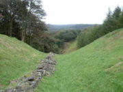
, it spanned approximately 39 miles (63 km) and was about ten feet (3 m) high and fifteen feet (5 m) wide. Security was bolstered by a deep ditch
Ditch
A ditch is usually defined as a small to moderate depression created to channel water.In Anglo-Saxon, the word dïc already existed and was pronounced 'deek' in northern England and 'deetch' in the south. The origins of the word lie in digging a trench and forming the upcast soil into a bank...
on the north side. The barrier was the second of two "great walls" created by the Romans in Caledonia
Roman Britain
Roman Britain was the part of the island of Great Britain controlled by the Roman Empire from AD 43 until ca. AD 410.The Romans referred to the imperial province as Britannia, which eventually comprised all of the island of Great Britain south of the fluid frontier with Caledonia...
. Its ruins are less evident than the better known Hadrian's Wall
Hadrian's Wall
Hadrian's Wall was a defensive fortification in Roman Britain. Begun in AD 122, during the rule of emperor Hadrian, it was the first of two fortifications built across Great Britain, the second being the Antonine Wall, lesser known of the two because its physical remains are less evident today.The...
to the south.
Construction began in AD 142 at the order of Roman Emperor
Roman Emperor
The Roman emperor was the ruler of the Roman State during the imperial period . The Romans had no single term for the office although at any given time, a given title was associated with the emperor...
Antoninus Pius
Antoninus Pius
Antoninus Pius , also known as Antoninus, was Roman Emperor from 138 to 161. He was a member of the Nerva-Antonine dynasty and the Aurelii. He did not possess the sobriquet "Pius" until after his accession to the throne...
, and took about twelve years to complete.
Pressure from the Caledonians
Caledonians
The Caledonians , or Caledonian Confederacy, is a name given by historians to a group of indigenous peoples of what is now Scotland during the Iron Age and Roman eras. The Romans referred to their territory as Caledonia and initially included them as Britons, but later distinguished as the Picts...
may have led Antoninus to send the empire's troops farther north. The wall was protected by sixteen forts with a number of small fortlets between them; troop movement was facilitated by a road linking all the sites known as the Military Way. The soldiers who built the wall commemorated the construction and their struggles with the Caledonians
Caledonians
The Caledonians , or Caledonian Confederacy, is a name given by historians to a group of indigenous peoples of what is now Scotland during the Iron Age and Roman eras. The Romans referred to their territory as Caledonia and initially included them as Britons, but later distinguished as the Picts...
in a number of decorative slabs, twenty of which still survive. Despite this auspicious start the wall was abandoned after only twenty years, and the garrisons relocated back to Hadrian's Wall. In 208 Emperor Septimius Severus
Septimius Severus
Septimius Severus , also known as Severus, was Roman Emperor from 193 to 211. Severus was born in Leptis Magna in the province of Africa. As a young man he advanced through the customary succession of offices under the reigns of Marcus Aurelius and Commodus. Severus seized power after the death of...
re-established legions at the wall and ordered repairs; this has led to the wall being referred to as the Severan Wall. However, the occupation ended only a few years later, and the wall was never fortified again. Most of the wall and its associated fortifications have been destroyed over time, but some remains are still visible. Many of these have come under the care of Historic Scotland
Historic Scotland
Historic Scotland is an executive agency of the Scottish Government, responsible for historic monuments in Scotland.-Role:As its website states:...
and the UNESCO
UNESCO
The United Nations Educational, Scientific and Cultural Organization is a specialized agency of the United Nations...
World Heritage Committee
World Heritage Committee
The World Heritage Committee establishes the sites to be listed as UNESCO World Heritage Sites. It is responsible for the implementation of the World Heritage Convention, defines the use of the World Heritage Fund and allocates financial assistance upon requests from States Parties...
.
Location and construction
Roman Emperor
The Roman emperor was the ruler of the Roman State during the imperial period . The Romans had no single term for the office although at any given time, a given title was associated with the emperor...
Antoninus Pius
Antoninus Pius
Antoninus Pius , also known as Antoninus, was Roman Emperor from 138 to 161. He was a member of the Nerva-Antonine dynasty and the Aurelii. He did not possess the sobriquet "Pius" until after his accession to the throne...
ordered the construction of the Antonine Wall around AD 142. Quintus Lollius Urbicus
Quintus Lollius Urbicus
Quintus Lollius Urbicus was governor of Roman Britain between the years 139 and 142, during the reign of the Roman Emperor Antoninus Pius. He is named in the text known as the Augustan History, and his name appears on five Roman inscriptions from Britain; his career is set out in detail on a pair...
, governor of Roman Britain
Roman Britain
Roman Britain was the part of the island of Great Britain controlled by the Roman Empire from AD 43 until ca. AD 410.The Romans referred to the imperial province as Britannia, which eventually comprised all of the island of Great Britain south of the fluid frontier with Caledonia...
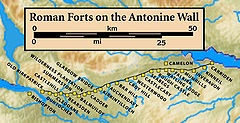
at the time, initially supervised the effort, which took about twelve years to complete. The wall stretches 39 miles (63 km) from Old Kilpatrick
Old Kilpatrick
Old Kilpatrick is a village in West Dunbartonshire, Scotland.The village is on the north bank of the River Clyde immediately to the north of the Forth and Clyde Canal, three miles from Clydebank on the road to Dumbarton. The Great Western Road runs through Old Kilpatrick, and the next village to...
in West Dunbartonshire
West Dunbartonshire
West Dunbartonshire is one of the 32 local government council areas of Scotland. Bordering onto the west of the City of Glasgow, containing many of Glasgow's commuter towns and villages as well as the city's suburbs, West Dunbartonshire also borders onto Argyll and Bute, Stirling, East...
on the Firth of Clyde
Firth of Clyde
The Firth of Clyde forms a large area of coastal water, sheltered from the Atlantic Ocean by the Kintyre peninsula which encloses the outer firth in Argyll and Ayrshire, Scotland. The Kilbrannan Sound is a large arm of the Firth of Clyde, separating the Kintyre Peninsula from the Isle of Arran.At...
to Carriden near Bo'ness
Bo'ness
Bo'ness, properly Borrowstounness, is a coastal town in the Central Lowlands of Scotland. It lies on a hillside on the south bank of the Firth of Forth within the Falkirk council area, north-west of Edinburgh and east of Falkirk. At the 2001 census, Bo'ness had a resident population of 13,961...
on the Firth of Forth
Firth of Forth
The Firth of Forth is the estuary or firth of Scotland's River Forth, where it flows into the North Sea, between Fife to the north, and West Lothian, the City of Edinburgh and East Lothian to the south...
. The wall was intended to extend Roman territory and dominance by replacing Hadrian's Wall
Hadrian's Wall
Hadrian's Wall was a defensive fortification in Roman Britain. Begun in AD 122, during the rule of emperor Hadrian, it was the first of two fortifications built across Great Britain, the second being the Antonine Wall, lesser known of the two because its physical remains are less evident today.The...
100 miles (160 km) to the south, as the frontier of Britannia
Roman Britain
Roman Britain was the part of the island of Great Britain controlled by the Roman Empire from AD 43 until ca. AD 410.The Romans referred to the imperial province as Britannia, which eventually comprised all of the island of Great Britain south of the fluid frontier with Caledonia...
. But while the Romans did establish many forts and temporary camps further north of the wall in order to protect their routes to the north of Scotland, they did not conquer the Caledonians
Caledonians
The Caledonians , or Caledonian Confederacy, is a name given by historians to a group of indigenous peoples of what is now Scotland during the Iron Age and Roman eras. The Romans referred to their territory as Caledonia and initially included them as Britons, but later distinguished as the Picts...
, and the Antonine Wall suffered many attacks. The Romans called the land north of the wall Caledonia, though in some contexts the term may refer to the whole area north of Hadrian's Wall.
Ditch (fortification)
A ditch in military engineering is an obstacle, designed to slow down or break up an attacking force, while a trench is intended to provide cover to the defenders...
on the north side, and a military way
Roman road
The Roman roads were a vital part of the development of the Roman state, from about 500 BC through the expansion during the Roman Republic and the Roman Empire. Roman roads enabled the Romans to move armies and trade goods and to communicate. The Roman road system spanned more than 400,000 km...
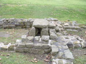
on the south. The Romans initially planned to build forts every six miles (10 km), but this was soon revised to every two miles (3.3 km), resulting in a total of nineteen forts along the wall. The best preserved but also one of the smallest forts is Rough Castle Fort
Rough Castle Fort
Rough Castle Fort is a Roman fort on the Antonine Wall roughly 2 kilometres south east of Bonnybridge near Tamfourhill in the Falkirk council area, Scotland....
. In addition to the forts, there are at least 9 smaller fortlets, very likely on roman mile spacings, which formed part of the original scheme, some of which were later replaced by forts. The most visible fortlet is Kinneil, at the eastern end of the Wall, near Bo'ness.
Inveresk
Inveresk is a civil parish and was formerly a village that now forms the southern part of Musselburgh. It is situated on slightly elevated ground at the south of Musselburgh in East Lothian, Scotland...
) and West (Outerwards and Lurg Moor), which should be considered as outposts and/or supply bases to the Wall itself. In addition a number of forts farther north were brought back into service in the Gask Ridge
Gask Ridge
The Gask Ridge is the modern name given to an early series of fortifications, built by the Romans in Scotland, close to the Highland Line.-Name:...
area, including Ardoch
Ardoch
Ardoch Roman Fort is an archaeological site just outside the village of Braco in Perthshire, Scotland, about 7 miles south of Crieff. At Ardoch are the remains of a Roman fort and castra which included Ardoch Tower...
, Strageath
Strageath
Strageath is a Roman camp near the River Earn in eastern Scotland. Strageath was one of a chain of camps that the Romans used in their march northward. Other notable camps in this chain are Ardoch, Battledykes, Stracathro, Raedykes and Normandykes....
, Bertha
Bertha
Bertha is a female Germanic name, from Old High German berhta meaning "bright one".The name occurs as a theonym, surviving as Berchta, a figure in Alpine folklore connected to the Wild Hunt, probably an epithet of *Frijjō in origin....
and probably Dalginross and Cargill
Cargill
Cargill, Incorporated is a privately held, multinational corporation based in Minnetonka, Minnesota. Founded in 1865, it is now the largest privately held corporation in the United States in terms of revenue. If it were a public company, it would rank, as of 2011, number 13 on the Fortune 500,...
.
Abandonment
The wall was abandoned after only twenty years, when the Roman legionRoman legion
A Roman legion normally indicates the basic ancient Roman army unit recruited specifically from Roman citizens. The organization of legions varied greatly over time but they were typically composed of perhaps 5,000 soldiers, divided into maniples and later into "cohorts"...
s withdrew to Hadrian's Wall in AD 162 (although there is evidence to suggest that they left the wall in AD 158/60, its reliability is unclear), and over time reached an accommodation with the Brythonic
Brythonic languages
The Brythonic or Brittonic languages form one of the two branches of the Insular Celtic language family, the other being Goidelic. The name Brythonic was derived by Welsh Celticist John Rhys from the Welsh word Brython, meaning an indigenous Briton as opposed to an Anglo-Saxon or Gael...
tribes of the area who they fostered as the buffer states which would later become "The Old North"
Hen Ogledd
Yr Hen Ogledd is a Welsh term used by scholars to refer to those parts of what is now northern England and southern Scotland in the years between 500 and the Viking invasions of c. 800, with particular interest in the Brythonic-speaking peoples who lived there.The term is derived from heroic...
. After a series of attacks in AD 197, Emperor Septimius Severus
Septimius Severus
Septimius Severus , also known as Severus, was Roman Emperor from 193 to 211. Severus was born in Leptis Magna in the province of Africa. As a young man he advanced through the customary succession of offices under the reigns of Marcus Aurelius and Commodus. Severus seized power after the death of...
arrived in Scotland in AD 208 to secure the frontier, and repaired parts of the wall. Although this re-occupation only lasted a few years, the wall is sometimes referred to by later Roman historians as the Severan Wall. This led to later scholars like Bede
Bede
Bede , also referred to as Saint Bede or the Venerable Bede , was a monk at the Northumbrian monastery of Saint Peter at Monkwearmouth, today part of Sunderland, England, and of its companion monastery, Saint Paul's, in modern Jarrow , both in the Kingdom of Northumbria...
mistaking references to the Antonine Wall for ones to Hadrian's Wall.
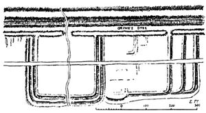
Grim's Dyke
In medieval histories, such as the chronicles of John of FordunJohn of Fordun
John of Fordun was a Scottish chronicler. It is generally stated that he was born at Fordoun, Mearns. It is certain that he was a secular priest, and that he composed his history in the latter part of the 14th century; and it is probable that he was a chaplain in the St Machar's Cathedral of...
, the wall is called Gryme's dyke. Fordun says that the name came from the grandfather of the imaginary king Eugenius son of Farquahar. This was corrupted into Graham's dyke – a name still found in Bo'ness
Bo'ness
Bo'ness, properly Borrowstounness, is a coastal town in the Central Lowlands of Scotland. It lies on a hillside on the south bank of the Firth of Forth within the Falkirk council area, north-west of Edinburgh and east of Falkirk. At the 2001 census, Bo'ness had a resident population of 13,961...
at the wall's eastern end – and then linked with Clan Graham
Clan Graham
Clan Graham is a Scottish clan who had territories in both the Scottish Highlands and Lowlands.-Origins:Legend has it that the first Graham was one Gramus who forced a breach in the Roman Antonine wall known as Graeme's Dyke in 420 A.D...
. Of note is that Graeme in some parts of Scotland is a nickname for the devil, and Gryme's Dyke would thus be the Devil's Dyke, mirroring the name of the Roman Limes
Limes
A limes was a border defense or delimiting system of Ancient Rome. It marked the boundaries of the Roman Empire.The Latin noun limes had a number of different meanings: a path or balk delimiting fields, a boundary line or marker, any road or path, any channel, such as a stream channel, or any...
in Southern Germany often called 'Teufelsmauer'. Grímr and Grim are bynames for Odin
Odin
Odin is a major god in Norse mythology and the ruler of Asgard. Homologous with the Anglo-Saxon "Wōden" and the Old High German "Wotan", the name is descended from Proto-Germanic "*Wodanaz" or "*Wōđanaz"....
or Wodan, who might be credited with the wish to build earthworks in unreasonably short periods of time. This name is the same one found as Grim's Ditch several times in England in connection with early ramparts: for example, near Wallingford, Oxfordshire or between Berkhamsted
Berkhamsted
-Climate:Berkhamsted experiences an oceanic climate similar to almost all of the United Kingdom.-Castle:...
(Herts) and Bradenham
Bradenham
Bradenham is the name of more than one place.In the United Kingdom:* Bradenham, Buckinghamshire* Bradenham, Norfolk* Bradenham, Suffolk...
(Bucks). Other names used by antiquarians include the Wall of Pius and the Antonine Vallum, after Antoninus Pius.
World Heritage Status
The UK government's nomination of the Antonine Wall for World Heritage statusWorld Heritage Site
A UNESCO World Heritage Site is a place that is listed by the UNESCO as of special cultural or physical significance...
to the international conservation body UNESCO
UNESCO
The United Nations Educational, Scientific and Cultural Organization is a specialized agency of the United Nations...
was first officially announced in 2003. It has been backed by the Scottish Government since 2005 and by Scotland's then Culture Minister Patricia Ferguson
Patricia Ferguson
Patricia Josephine Ferguson is a Labour Member of the Scottish Parliament for Glasgow Maryhill, a seat which she has held since 1999.- Background :...
since 2006. It became the UK's official nomination in late January 2007, and MSP
Member of the Scottish Parliament
Member of the Scottish Parliament is the title given to any one of the 129 individuals elected to serve in the Scottish Parliament.-Methods of Election:MSPs are elected in one of two ways:...
s were called to support the bid anew in May 2007. The Antonine Wall was listed as an extension to the World Heritage Site "Frontiers of the Roman Empire" on 7 July 2008. Though the Antonine is mentioned in text, it makes no appearance on the map of UNESCO's map of world heritage properties.
Historic Scotland
Several individual sites along the line of the wall are in the care of Historic ScotlandHistoric Scotland
Historic Scotland is an executive agency of the Scottish Government, responsible for historic monuments in Scotland.-Role:As its website states:...
. These are:
All sites are unmanned and open at all reasonable times.
Mapping the wall
William Roy
Major-General William Roy FRS was a Scottish military engineer, surveyor, and antiquarian. He was an innovator who applied new scientific discoveries and newly emerging technologies to the accurate geodetic mapping of Great Britain....
, of Ordnance Survey
Ordnance Survey
Ordnance Survey , an executive agency and non-ministerial government department of the Government of the United Kingdom, is the national mapping agency for Great Britain, producing maps of Great Britain , and one of the world's largest producers of maps.The name reflects its creation together with...
fame. He provided accurate and detailed drawings of its remains, and where the wall has been destroyed by later development, his maps and drawings are now the only reliable record of it.
In fiction
The Northern Wall is depicted in some of Rosemary SutcliffRosemary Sutcliff
Rosemary Sutcliff CBE was a British novelist, and writer for children, best known as a writer of historical fiction and children's literature. Although she was primarily a children's author, the quality and depth of her writing also appeals to adults; Sutcliff herself once commented that she wrote...
's historical fiction novels; as a fully functioning outpost of Roman power in The Mark of the Horse Lord
The Mark of the Horse Lord
The Mark of the Horse Lord is a historical novel for children written by Rosemary Sutcliff and published in 1965. It won the first Phoenix Award in 1985....
, and as an abandoned ruin in Frontier Wolf.
In Max Brooks
Max Brooks
Maximillian Michael "Max" Brooks is an American author and screenwriter, with a particular interest in zombies. Brooks is also a television and voice-over actor.- Early life and education :...
's post-apocalyptic novel World War Z
World War Z
World War Z: An Oral History of the Zombie War is a 2006 post-apocalyptic horror novel by Max Brooks. It is a follow-up to his 2003 book The Zombie Survival Guide. Rather than a grand overview or narrative, World War Z is a collection of individual accounts in the form of first-person anecdote...
, the Antonine Wall marks the line at which the British establish their defense against the zombies and the beginning of their free zone.
See also
- Hadrian's WallHadrian's WallHadrian's Wall was a defensive fortification in Roman Britain. Begun in AD 122, during the rule of emperor Hadrian, it was the first of two fortifications built across Great Britain, the second being the Antonine Wall, lesser known of the two because its physical remains are less evident today.The...
- Gask RidgeGask RidgeThe Gask Ridge is the modern name given to an early series of fortifications, built by the Romans in Scotland, close to the Highland Line.-Name:...
- Trimontium
- Scotland during the Roman EmpireScotland during the Roman EmpireScotland during the Roman Empire encompasses a period of protohistory from the arrival of Roman legions in c. AD 71 to their departure in 213. The history of the period is complex: the Roman empire influenced every part of Scotland during the period, however the occupation was neither complete nor...
- World Heritage Sites in ScotlandWorld Heritage Sites in ScotlandWorld Heritage Sites in Scotland are specific locations that have been included in the UNESCO World Heritage Programme list of sites of outstanding cultural or natural importance to the common heritage of humankind. Historic Scotland is responsible for 'cultural' sites as part of their wider...
- National Museums of ScotlandNational Museums of ScotlandNational Museums Scotland is the organization that runs several national museums of Scotland. It is one of the country's National Collections, and holds internationally important collections of natural sciences, decorative arts, world cultures, science and technology, and Scottish history and...
External links
- http://www.antoninewall.org/
- http://www.antonineway.co.uk
- http://www.historic-scotland.gov.uk/antoninewall
- http://www.falkirkonline.net/antoninewall
- http://www.kinneil.org.uk/attractions
- http://www.athenapub.com/antwall1.htm
- http://www.athenapub.com/britsite/hillfoot.htm
- http://www.theromangaskproject.org.uk/
- http://www.roman-britain.org/frontiers/antonine.htm
- http://www.almac.co.uk/FalkirkTCM/Rome.htm
- The Antonine Wall and Barr Hill
- Richard Stillwell, ed. Princeton Encyclopedia of Classical Sites, 1976: "Antonine Wall, Scotland"
- Museum news
- Information on the Antonine Wall - Clyde Waterfront Heritage