
.gif)
Interstate 495 (Capital Beltway)
Encyclopedia
Interstate 495 is a 64 miles (103 km) Interstate Highway that surrounds the United States
' capital of Washington, D.C.
, and its inner suburbs in adjacent Maryland
and Virginia
. I-495 is widely known as the Capital Beltway or simply the Beltway, especially when the context of Washington, D.C., is clear. It is the basis of the phrase "Inside the Beltway
", used when referring to issues dealing with American government
and politics
. Interstate 95
utilizes the southern and eastern half of the Capital Beltway to circumnavigate Washington, D.C., and is cosigned with I-495 along that route.
This circumferential roadway is located not only in the states of Virginia
and Maryland
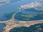
, but also crosses briefly through the District of Columbia, near the western end of the Woodrow Wilson Bridge
over the Potomac River
. The Beltway passes through Prince George's County
and Montgomery County
in Maryland, and Fairfax County
and the independent city
of Alexandria
in Virginia.
The Cabin John Parkway
, a short connector between I-495 and the Clara Barton Parkway near the Potomac River along the Maryland-Virginia border, is considered an Interstate spur (I-495X) by the Maryland State Highway Administration
.
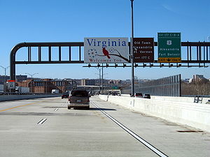 The Capital Beltway encircles Washington, D.C.
, in adjacent Maryland
and Virginia
, entering the District of Columbia only briefly, on an over-water portion of the Woodrow Wilson Bridge
over the Potomac River
several miles south of downtown Washington. The two directions of travel, clockwise
and counterclockwise (looking at a map), have become known respectively as the "Inner Loop" and the "Outer Loop". The route descriptions below follow the direction of the Outer Loop, starting at the Woodrow Wilson Bridge
over the Potomac River, south of Washington.
Most Beltway interchanges provide access to Washington, with I-95
and I-295 from the south, I-66 from the west, and US 50 from both the west and the east among the most frequently used. More scenic routes from the Beltway into the District are offered by the George Washington Memorial Parkway
along the Virginia side of the Potomac, the Clara Barton Parkway along the Maryland side of the river, and the Baltimore-Washington Parkway
, approaching Washington from the northeast.
Originally, the entire Beltway was simply I-495, and I-95 was planned to serve downtown Washington, D.C., from the south and north, intersecting the Beltway in Virginia and in Maryland. However, environmental litigation stopped completion of this plan, and the built portion of I-95 inside the Beltway from the south northward into downtown Washington was redesignated I-395 in 1977. The small built portion from the north was converted into a park-and-ride lot. I-95 was then rerouted (and so signed) along the eastern side of the Beltway, with the I-495 designation left only along the western side. In 1989, the I-495 designation was returned to the eastern portion as well, with the highway co-signed as I-95 and I-495 along this route.
over the tidal
Potomac River
between Alexandria, Virginia
, and Prince George's County, Maryland
. About 300 feet (90 m) of the western, near-shore portion of the bridge crosses the tip of the southernmost corner of the District of Columbia. However, signage for these boundary crossings is lacking.
 The Beltway (here I-95 and I-495 together) enters Maryland
during its Potomac River
crossing over the Woodrow Wilson Bridge
, west of Forest Heights
and National Harbor
. After crossing the Potomac, I-95/I-495 immediately meets the southern terminus of Interstate 295, known as the Anacostia
Freeway, a route that serves downtown Washington to the north, connecting in Washington to Interstate 395. The highway next intersects MD 210
, a major north–south route from southern D.C. to Indian Head
in Charles County
, Maryland.
Heading northeastward, the Beltway (I-95/I-495) interchanges with various local highways, including MD 5
and MD 4
on either side of Andrews Air Force Base
, which the Beltway travels near its northern edge. (Both MD 5 and MD 4 extend westward into D.C., and southeastward into Southern Maryland
.) Past the MD 4 interchange, the Beltway turns north through Glenarden
, interchanging with MD 202
.
The Beltway then interchanges with US 50/unsigned I-595
, a major highway from downtown Washington eastward to Annapolis
, Maryland, and the Chesapeake Bay Bridge
to Maryland's Eastern Shore. Both US 50 and MD 450 (which interchanges with the Beltway slightly northward) provide access to the New Carrollton Metro
, MARC
commuter rail, and Amtrak
stations, and the New Carrollton
area.
Turning northwest, the Beltway then enters Greenbelt Park
, intersecting the Baltimore-Washington Parkway
(B-W Parkway) in the northeastern edge of the park. Just after the B-W Parkway, I-95/I-495 passes an interchange with MD 201
, which connects to the southern terminus of the B-W Parkway at US 50
near the D.C. line. Now turned fully west, the Beltway runs through the northern edge of College Park
, interchanging with the access roadway for the Greenbelt
Metro
and MARC
commuter rail stations, then US 1
.
Beyond the US 1 interchange, I-95 separates from I-495 at the College Park Interchange
. I-495 continues west, alone, on the Capital Beltway, while I-95 turns northeast towards Baltimore, New York City, and Boston. The interchange includes access to a Park and Ride
lot which was originally paved as part of I-95's route within the Beltway.
, I-495 crosses into Montgomery County, Maryland
, entering a heavily developed and populated area. Passing underneath MD 212
with no access, the route interchanges with MD 650
near the George Washington Cemetery. After bisecting Northwest Branch Park, the Beltway interchanges with MD 193
and US 29
south of Four Corners; the two interchanges are little more than 1/2 mile apart. Southbound US 29 is the main route into downtown Silver Spring
, continuing into Washington.
Squeezing past Argyle Park
and Sligo Creek Golf Course, the Beltway interchanges with MD 97
northwest of Silver Spring, then follows an alignment formerly known as Rock Creek Parkway. The route twists along the alignment, through and around Rock Creek Park
, then interchanges with MD 185
near the National Naval Medical Center
. Turning northwest, I-495 soon encounters the southern terminus of Interstate 270
, which extends westward to meet I-70
in Frederick
, Maryland.
I-270 and I-495 split at a highly complex Y-junction, with separate HOV connections to I-270's HOV lanes and separate ramps to and from MD 355
(formerly US 240
). The old Rock Creek Parkway alignment follows I-270 north, while I-495 turns west and enters the only other six-lane segment of the Beltway still in existence; significant levels of traffic exit onto I-270 north, leaving the six-lane segment west of the split adequate.
Interchanging with MD 187
, I-495 soon meets the Interstate 270 Spur, the other side of the I-270/I-495 triangle. I-495 joins I-270 Spur at a converging wye junction; Inner Loop traffic exits from itself at the southern terminus of I-270 Spur, while Outer Loop traffic crosses the spur and enters it from the right. The two carriageways of I-495 temporarily widen to five lanes each until the MD 190
and Cabin John Parkway
interchanges. (MD 190 provides access to the northwestern portion of Washington, D.C., and to the Potomac
and Great Falls, Maryland areas of Maryland's Montgomery County
, while the Cabin John Parkway extends to the Clara Barton Parkway along the Potomac River.)
After these interchanges, the Beltway then narrows to eight lanes again. Turning sharply to the west, I-495 meets the Clara Barton Parkway along the north side of the Potomac River
; this parkway provides a scenic route eastward into the western part of Washington, and westward toward the Potomac River's Great Falls. After this interchange, the Beltway soon crosses the Potomac Gorge
into Virginia
over the ten-lane American Legion Memorial Bridge
.
, Virginia, I-495 encounters the western terminus of the George Washington Memorial Parkway
at a trumpet interchange; the Parkway provides a scenic route to Arlington, Virginia, and downtown Washington. The Beltway then continues south, next interchanging with VA 193
south of Dranesville District Park, then reaches the extensive triangle of interchanges between I-495, the Dulles Airport Access Road, VA 267
, and VA 123
. The eastbound Dulles Access Road here also provides access to I-66 for Outer Loop Beltway traffic. The former interchange with the toll road (VA 267) is a directional interchange, while the latter is a cloverleaf; the entire complex occurs east of the Tysons Corner
business district.
Now running south, the Beltway interchanges with VA 7
(Leesburg Pike) east of Tysons Corner; passing Dunn Loring
to the east, I-495 soon reaches the complex interchange with Interstate 66
, which extends westward to I-81 in the Shenandoah Valley
near Strasburg
, Virginia, and eastward to Arlington and downtown Washington. In a similar design as the I-270/I-495 interchange, dedicated HOV connections exist between I-495 and I-66, with many reversible and other directional ramps providing the remaining connections. There is no access between the Outer Loop and eastbound I-66 at this interchange. Instead, Outer Loop traffic must use the eastbound Dulles Access Road exit 3 miles (5 km) to the north in order to reach I-66 East. There are multiple ramps from I-66 east to the Inner Loop, with one ramp exiting from the left side of I-66 east and the other exiting from the right.
South of the I-66 interchange, the Beltway crosses under US 29
and VA 237
with no access, then encounters a large braided interchange between I-495, US 50
, and two local roads; the direct interchange between I-495 and US 50 is a full cloverleaf, while the braided local interchanges between I-495, US 50, and the local roads are modified SPUI
s. The entire complex is bounded on the northeast side by Fairview Lake and on the southwest side by an office complex.
Continuing due south, the route then interchanges with Gallows Road, then skirts the eastern edge of Mill Creek Park before interchanging with VA 236
southwest of Annandale Community Park. Running along the eastern edge of Wakefield Park, the Beltway turns southeast and interchanges with VA 620 before turning east near Flag Run Park and entering Springfield
, meeting the Springfield Interchange
with I-95 southeast of the Shirley Industrial Complex.
. I-495 also meets the southern terminus of Interstate 395 within the same massive interchange complex.
Running due east away from the interchange, crossing to the south of Backlick Stream Valley Park, the Beltway (now I-95/I495) interchanges with VA 613 a mile east of the Springfield Interchange. Continuing east, the Beltway encounters a diamond interchange with a connector road linking to Eisenhower Avenue, which parallels the Beltway for a short distance. Skirting the northern edges of Loftridge Park and Burgundy Park the two routes enter Alexandria
and soon reach VA 241
, a direct route into the city, currently under major reconstruction. Within the interchange, the Beltway nears the western approach to the Woodrow Wilson Memorial Bridge.
Continuing east the two routes encounter US 1
, a major north-south highway providing access to Alexandria, Arlington, and downtown Washington, as well as various points south in Fairfax County
, Virginia. Finally, beyond this complex interchange, I-95 and I-495 together cross Alexandria's Jones Point Park and exit Virginia via the Woodrow Wilson Bridge
.
over the Potomac River
) was opened on December 21, 1961; the highway was completed on August 17, 1964.
Originally designated I-495, in 1977 the eastern portion of the Beltway was re-designated I-95
when a proposed alignment of I-95 from New York Avenue
in Washington, D.C., through Prince George's County, Maryland
to I-495 was canceled. Motorists never fully adjusted to the two halves of the Beltway having different numbers. According to Ron Shaffer of the Washington Post, "There were signs stating that to continue on the Beltway, you had to get off at the next exit, when all you really had to do was keep going straight. Lots of resistance from bureaucrats, but eventually we got dual I-95/I-495 signs on the eastern half of the Beltway." So, in 1989, the I-495 designation was restored to the eastern portion, making it a dual I-95/I-495.
Traveling clockwise, the Beltway is designated as the "Inner Loop"; traveling counter-clockwise, it is designated as the "Outer Loop". This parlance too has led to its own confusion, with unfamiliar motorists imagining two separate, distinct highway alignments, one some distance inside the other. At entrance ramps to the Beltway and on the on-highway signage, "Inner Loop" and "Outer Loop" shields are posted in conjunction with the route marker shields, although the terms are not emphasized in signage.
The Beltway was originally envisioned as primarily a bypass for long-distance eastern seaboard traffic to avoid driving directly through Washington. However, the explosive growth both of housing and business in the Washington suburbs following the Beltway's completion quickly made the Beltway the area's "main street" for local traffic as well. Numerous large shopping malls, community colleges, sports and concert stadiums, and corporate employment centers were purposely built adjacent to the Beltway, and these added greatly to the traffic, as has the passenger growth of regional airports accessed by the Beltway. The formerly more affordable price of housing in Southern Maryland versus northern Virginia, also led tens of thousands of commuters to live in Southern Maryland and commute on the Beltway to Virginia. The newer Fairfax County Parkway
in the 1990s helped ease some traffic on the Virginia beltway; however, various proposals to build another complete outer beltway
in the outer suburbs cannot get off the ground, since local governments in Maryland object to building additional Potomac River
crossings as well as destroying protected "open space" and creating sprawl.
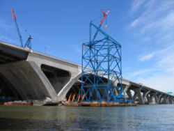
– where eight lanes were squeezed into six – was particularly onerous, with miles-long backups daily during commuter rush hours and on heavily traveled weekends. Relief for this bottleneck came on May 30, 2008, when the 12-lane replacement bridge opened to traffic in both directions (the six-lane span carrying Outer Loop traffic had opened in June 2006). Two of the lanes on the Wilson are being held in reserve for future use as bus rapid transit or rail transit.
Two intersections on the Capital Beltway are ranked in the top 20 on a study of the "worst bottlenecks in the nation." They are the I-495 at I-270
interchange in Montgomery County, Maryland
, ranked third overall, which receives 243,425 cars daily, and the I-495 at I-95 interchange
in Prince George's County, Maryland
, ranked 11th, with 185,125 cars. The Springfield Interchange
, where I-395
, I-95, and I-495 meet, was previously ranked fifth worst in the nation, but recent improvements have taken it off the top 20. Local commuters refer to the Springfield Interchange
as "The Mixing Bowl," although this designation is reserved by highway officials for the even more complicated interchange
complex adjacent to The Pentagon
on the original Henry G. Shirley Memorial Highway
(currently better-known as Interstate 395
) at State Route 27
in Arlington
.
In April 2005, the Virginia Department of Transportation
signed an agreement with two private companies to build high-occupancy toll lanes on the stretch of the Beltway between Springfield and Georgetown Pike. Construction began in 2008. Maryland officials are considering such lanes on their segment of the Beltway, as well as other major commuter highways in the state. Locals who disapprove of these projects have nicknamed them "Lexus
Lanes" because of the potential high price for using the lanes in exchange for bypassing congestion. These new lanes are one stage of a controversial project to widen the beltway, with the second stage involving widening the beltway to 12 lanes; opponents have called for various alternatives to this project (as well as the controversial Intercounty Connector project) which would divert many vehicles off the northern beltway. The proposed Purple Line of the Washington Metro
subway system is just one example.
The Beltway has been improved since it opened. The American Legion Bridge was expanded by two lanes. HOV lanes were added between River Road and the I-270 Spur in Montgomery County, Maryland. The interchange between I-95 and the Beltway in Montgomery County, Maryland was originally designed to be a cloverleaf to allow I-95 to extend southward toward the District of Columbia. After I-95 was realigned onto the Beltway, a flyover ramp was built to allow I-95 through traffic to have two high-speed lanes. The interchange between U.S. Route 50 and I-95/I-495 in Prince Georges County, Maryland was upgraded from a simple cloverleaf to a hybrid turbine interchange. In the Beltway's original configuration, I-295 and Indian Head Highway had separate interchanges. As a result, north-south traffic between I-295 and Indian Head Highway was forced to merge onto a congested section of the Beltway for approximately one mile. As a congestion relief measure, I-295 was extended over the Beltway and continued parallel to it so that the two highways were directly connected independent of the beltway. However, these interchanges were redesigned and rebuilt to accommodate the expansion of the Wilson Bridge and the construction of dedicated ramps to National Harbor.
 The Springfield Interchange
in Virginia completed reconstruction in 2007. The eight-year, nearly $676 million project worked to eliminate weaving among local and long-distance traffic between I-95, I-395, the Beltway, and State Route 644
.
The Woodrow Wilson Bridge
underwent reconstruction in a major project that began in 1999; it now provides express and local lanes for both the Inner and Outer Loops. The new Wilson Bridge is higher and wider than the original 1961 span, which was demolished in 2006. The Outer Loop span opened in June 2006, and the Inner Loop span opened in May 2008.
Also, in association with the Wilson Bridge project, the Telegraph Road
and U.S. 1 interchanges (exits 176 and 177) in Alexandria, Virginia are being rebuilt. The I-295 and MD 210
interchanges (exits 2 and 3) in Maryland have also recently been rebuilt.
The Branch Avenue (Maryland Route 5
) Interchange has also been recently improved.
has authorized a public-private partnership
to construct high-occupancy toll (HOT) lanes in Northern Virginia. The project will add two lanes to I-495 in each direction from just west of the Springfield Interchange to just north of the Dulles Toll Road, and will include replacement of more than 50 bridges, overpasses, and major interchanges.
Drivers of vehicles with fewer than three occupants will be required to pay a toll to use the lanes. Tolls will change dynamically, with higher tolls charged during periods of heaviest congestion. Drivers using the HOT Lanes will be required to carry an E-Z Pass transponder to allow electronic toll collection, eliminating the need for toll booths. Tolls will be waived for buses, carpools of at least three people, motorcycles, and emergency vehicles. If more than a specified number of carpools or buses use the lanes, Virginia must pay the tolls for the excess vehicles.
At the north and south termini of the HOT lanes, motorists will be able to transition directly between the HOT lanes and the I-495 general purpose lanes. However, elsewhere along the corridor, access to and from the HOT lanes will be only from cross roads. Some cross roads will provide access to both HOT lanes and general purpose lanes; others will have access only to one system or the other. Many HOT lane access points will serve traffic in only one direction of I-495, which is intended to complement typical commuting patterns. HOT lane interchanges under construction are as follows:
The original scope of the HOT project is covered by a fixed-price $1.3 billion contract between concessionaire Capital Beltway Express LLC and contractor Fluor-Lane LLC. The partnership has proposed extending the scope of the project to north to the Potomac River.
, exits on the Maryland portion were renumbered to the current format, counterclockwise with exit numbers assigned to mileposts. This caused problems because there were some exits that had the same number in Maryland and Virginia. Around 2000, this problem was solved by renumbering all of the Virginia exits. The exit numbers between the American Legion Memorial Bridge
and the Springfield Interchange
– Interstate 495's intersection with Interstate 395
and I-95 in Virginia
– became a continuation of the Maryland exit numbers from the Woodrow Wilson Bridge
to the American Legion Memorial Bridge
. The exit numbers between the Springfield Interchange
and the Woodrow Wilson Bridge became a continuation of the exit numbers of I-95 in Virginia; such exit numbers are much higher than those on the rest of the Beltway, but continue to increase in the counterclockwise direction.
|-
!County
!Location
!Mile
!Exit
!Destinations
!width=25%|Notes
|-
|colspan=2|Virginia
–Maryland
state line
|0.00
| colspan="3" style="text-align:center;"|Woodrow Wilson Bridge
– Potomac River
|-
|rowspan=19|Prince George's
|rowspan=4|Oxon Hill
|-
|1.73
|2
| / National Harbor Boulevard – Washington
, National Harbor
|Split into exits 2A (National Harbor) and 2B (I-295)
|-
|2.77
|3
|
|Split into exits 3A (south) and 3B (north)
|-
|4.33
|4
|
|Split into exits 4A (south) and 4B (north)
|-
||Temple Hills
|7.30
|7
|
|Split into exits 7A (south) and 7B (north)
|-
|rowspan=2|Morningside
|9.07
|rowspan=2|9
|rowspan=2|
|Northbound exit and southbound entrance
|-
|9.69
|Southbound exit and northbound entrance
|-
||Forestville
|10.78
|11
|, Washington
|Split into exits 11A (south) and 11B (north)
|-
|rowspan=3|Largo
|13.14
|13
|Ritchie–Marlboro Road – Capitol Heights
, Upper Marlboro
|Unsigned MD 221A
|-
|14.78
|15
|
|Split into exits 15A (east) and 15B (west)
|-
|15.83
|16
|Arena Drive
|Unsigned MD 202F
|-
||Landover
|16.56
|17
|
|Split into exits 17A (east) and 17B (west) southbound
|-
||Glenarden
|18.54
|19
|, Washington
|I-595 is unsigned; split into exits 19A (east) and 19B (west)
|-
||New Carrollton
|19.59
|20
|
|Split into exits 20A (east) and 20B (west) northbound
|-
|rowspan=3|Greenbelt
|22.12
|22
|Baltimore–Washington Parkway – Baltimore, Washington
|Split into exits 22A (north) and 22B (south)
|-
|23.04
|23
|
|
|-
|24.25
|24
|Greenbelt Metro and MARC Station
|Southbound exit and northbound entrance
|-
|rowspan=2|College Park
|25.19
|25
|
|Split into exits 25A (north) and 25B (south) southbound
|-
|26.11
|27
|, Park and Ride
|College Park Interchange
; north end of concurrency with I-95; southbound I-95 uses exit 27 to access exit 25 and the park and ride
|-
|rowspan=12|Montgomery
||Hillandale
|
|28
|
|Split into exits 28A (north) and 28B (south)
|-
|rowspan=2|Silver Spring
|
|29
|
|
|-
|
|30
|
|Split into exits 30A (south) and 30B (north) eastbound
|-
||Forest Glen
|0
|31
|
|Split into exits 31A (south) and 31B (north) eastbound
|-
||Chevy Chase
|.00
|33
|
|
|-
|rowspan=6|Bethesda
|
|34
|
|
|-
|
|35
|
|Westbound exit and eastbound entrance
|-
|
|36
|
|-
|
|38
|
|Northbound exit and southbound entrance
|-
|
|39
|, Washington
|Split into exits 39A (west) and 39B (east) northbound
|-
|
|40
|Cabin John Parkway
– Glen Echo
|Southbound exit and northbound entrance
|-
||Carderock
|
|41
|Clara Barton Parkway – Carderock
, Great Falls
|
|-
|colspan=2|Maryland
–Virginia
state line
|
| colspan="3" style="text-align:center;"|American Legion Memorial Bridge
– Potomac River
|-
|rowspan=15|Fairfax
|rowspan=2|McLean
|
|43
|George Washington Memorial Parkway
– Washington
|rowspan=2|Exits 43 and 44 are combined southbound
|-
|
|44
|
|-
|rowspan=3|Tysons Corner
|
|45
|
|Split into exits 45A (west) and 45B (east) northbound; no access from northbound I-495 to eastbound SR 267 or from westbound SR 267 to southbound I-495
|-
|
|46
|
|Split into exits 46A (south) and 46B (north)
|-
|
|47
|
|Split into exits 47A (west) and 47B (east)
|-
|rowspan=3|Dunn Loring
|
|49
|, Washington
|Split into exits 49A (west), 49B (east), and 49C (west-left exit) northbound; no access from southbound I-495 to eastbound I-66 or from westbound I-66 to northbound I-495
|-
|
|50
|
|Split into exits 50A (west) and 50B (east)
|-
|
|51
|
|
|-
|rowspan=2|Annandale
|
|52
|
|Split into exits 52A (west) and 52B (east)
|-
|
|54
|
|Split into exits 54A (west) and 54B (east)
|-
|rowspan=2|Springfield
|rowspan=2|0
|57
|rowspan=2|, Washington
|rowspan=2|Springfield Interchange
; south end of concurrency with I-95; split into exits 57A (I-95 south) and 57B (I-395 north) on I-495 from Tysons Corner; split into exits 170A (I-495 toward Tysons Corner) and 170B (I-395 north) on I-95 / I-495 from Alexandria
|-
|170
|-
||Franconia
|
|173
|
|
|-
||Rose Hill
|
|174
|Eisenhower Avenue Connector
|
|-
||Huntington
|
|176
|
|Split into exits 176A (south) and 176B (north)
|-
| colspan="2"|Alexandria
|
|177
|
|Split into exits 177A (south) and 177B (north); single ramp, Exit 177C, from southbound I-95 / I-495 to SR 400
|-
|colspan=2|Virginia
–Maryland
state line
|
| colspan="3" style="text-align:center;"|Woodrow Wilson Bridge
– Potomac River
United States
The United States of America is a federal constitutional republic comprising fifty states and a federal district...
' capital of Washington, D.C.
Washington, D.C.
Washington, D.C., formally the District of Columbia and commonly referred to as Washington, "the District", or simply D.C., is the capital of the United States. On July 16, 1790, the United States Congress approved the creation of a permanent national capital as permitted by the U.S. Constitution....
, and its inner suburbs in adjacent Maryland
Maryland
Maryland is a U.S. state located in the Mid Atlantic region of the United States, bordering Virginia, West Virginia, and the District of Columbia to its south and west; Pennsylvania to its north; and Delaware to its east...
and Virginia
Virginia
The Commonwealth of Virginia , is a U.S. state on the Atlantic Coast of the Southern United States. Virginia is nicknamed the "Old Dominion" and sometimes the "Mother of Presidents" after the eight U.S. presidents born there...
. I-495 is widely known as the Capital Beltway or simply the Beltway, especially when the context of Washington, D.C., is clear. It is the basis of the phrase "Inside the Beltway
Inside the Beltway
"Inside the Beltway" is a phrase used to characterize parts of the real or imagined American political system. The name refers to the Capital Beltway , a circumferential highway , completed in 1964, that encircles Washington, D.C., the capital of the United States.The phrase is commonly used to...
", used when referring to issues dealing with American government
Government
Government refers to the legislators, administrators, and arbitrators in the administrative bureaucracy who control a state at a given time, and to the system of government by which they are organized...
and politics
Politics
Politics is a process by which groups of people make collective decisions. The term is generally applied to the art or science of running governmental or state affairs, including behavior within civil governments, but also applies to institutions, fields, and special interest groups such as the...
. Interstate 95
Interstate 95
Interstate 95 is the main highway on the East Coast of the United States, running parallel to the Atlantic Ocean from Maine to Florida and serving some of the most populated urban areas in the country, including Boston, Providence, New Haven, New York City, Newark, Philadelphia, Baltimore,...
utilizes the southern and eastern half of the Capital Beltway to circumnavigate Washington, D.C., and is cosigned with I-495 along that route.
This circumferential roadway is located not only in the states of Virginia
Virginia
The Commonwealth of Virginia , is a U.S. state on the Atlantic Coast of the Southern United States. Virginia is nicknamed the "Old Dominion" and sometimes the "Mother of Presidents" after the eight U.S. presidents born there...
and Maryland
Maryland
Maryland is a U.S. state located in the Mid Atlantic region of the United States, bordering Virginia, West Virginia, and the District of Columbia to its south and west; Pennsylvania to its north; and Delaware to its east...
, but also crosses briefly through the District of Columbia, near the western end of the Woodrow Wilson Bridge
Woodrow Wilson Bridge
The Woodrow Wilson Memorial Bridge is a bascule bridge that spans the Potomac River between the independent city of Alexandria, Virginia and Oxon Hill in Prince George's County, Maryland, United States. While over the water near the Virginia shore, it crosses the southern tip of the District of...
over the Potomac River
Potomac River
The Potomac River flows into the Chesapeake Bay, located along the mid-Atlantic coast of the United States. The river is approximately long, with a drainage area of about 14,700 square miles...
. The Beltway passes through Prince George's County
Prince George's County, Maryland
Prince George's County is a county located in the U.S. state of Maryland, immediately north, east, and south of Washington, DC. As of 2010, it has a population of 863,420 and is the wealthiest African-American majority county in the nation....
and Montgomery County
Montgomery County, Maryland
Montgomery County is a county in the U.S. state of Maryland, situated just to the north of Washington, D.C., and southwest of the city of Baltimore. It is one of the most affluent counties in the United States, and has the highest percentage of residents over 25 years of age who hold post-graduate...
in Maryland, and Fairfax County
Fairfax County, Virginia
Fairfax County is a county in Virginia, in the United States. Per the 2010 Census, the population of the county is 1,081,726, making it the most populous jurisdiction in the Commonwealth of Virginia, with 13.5% of Virginia's population...
and the independent city
Independent city
An independent city is a city that does not form part of another general-purpose local government entity. These type of cities should not be confused with city-states , which are fully sovereign cities that are not part of any other sovereign state.-Historical precursors:In the Holy Roman Empire,...
of Alexandria
Alexandria, Virginia
Alexandria is an independent city in the Commonwealth of Virginia. As of 2009, the city had a total population of 139,966. Located along the Western bank of the Potomac River, Alexandria is approximately six miles south of downtown Washington, D.C.Like the rest of northern Virginia, as well as...
in Virginia.
The Cabin John Parkway
Cabin John Parkway
Cabin John Parkway is an automobile parkway in the U.S. state of Maryland. The parkway runs from Clara Barton Parkway in Cabin John north to the Capital Beltway in Bethesda...
, a short connector between I-495 and the Clara Barton Parkway near the Potomac River along the Maryland-Virginia border, is considered an Interstate spur (I-495X) by the Maryland State Highway Administration
Maryland State Highway Administration
The Maryland State Highway Administration is the state agency responsible for maintaining Maryland numbered highways outside of Baltimore City...
.
Route description
Washington, D.C.
Washington, D.C., formally the District of Columbia and commonly referred to as Washington, "the District", or simply D.C., is the capital of the United States. On July 16, 1790, the United States Congress approved the creation of a permanent national capital as permitted by the U.S. Constitution....
, in adjacent Maryland
Maryland
Maryland is a U.S. state located in the Mid Atlantic region of the United States, bordering Virginia, West Virginia, and the District of Columbia to its south and west; Pennsylvania to its north; and Delaware to its east...
and Virginia
Virginia
The Commonwealth of Virginia , is a U.S. state on the Atlantic Coast of the Southern United States. Virginia is nicknamed the "Old Dominion" and sometimes the "Mother of Presidents" after the eight U.S. presidents born there...
, entering the District of Columbia only briefly, on an over-water portion of the Woodrow Wilson Bridge
Woodrow Wilson Bridge
The Woodrow Wilson Memorial Bridge is a bascule bridge that spans the Potomac River between the independent city of Alexandria, Virginia and Oxon Hill in Prince George's County, Maryland, United States. While over the water near the Virginia shore, it crosses the southern tip of the District of...
over the Potomac River
Potomac River
The Potomac River flows into the Chesapeake Bay, located along the mid-Atlantic coast of the United States. The river is approximately long, with a drainage area of about 14,700 square miles...
several miles south of downtown Washington. The two directions of travel, clockwise
Clockwise
Circular motion can occur in two possible directions. A clockwise motion is one that proceeds in the same direction as a clock's hands: from the top to the right, then down and then to the left, and back to the top...
and counterclockwise (looking at a map), have become known respectively as the "Inner Loop" and the "Outer Loop". The route descriptions below follow the direction of the Outer Loop, starting at the Woodrow Wilson Bridge
Woodrow Wilson Bridge
The Woodrow Wilson Memorial Bridge is a bascule bridge that spans the Potomac River between the independent city of Alexandria, Virginia and Oxon Hill in Prince George's County, Maryland, United States. While over the water near the Virginia shore, it crosses the southern tip of the District of...
over the Potomac River, south of Washington.
Most Beltway interchanges provide access to Washington, with I-95
Interstate 95 in Virginia
In the Commonwealth of Virginia, Interstate 95 runs through the state. It runs concurrently for with Interstate 64 in Richmond, and meets the northern terminus of Interstate 85 in Petersburg. Though Interstate 95 was originally planned to go straight through Washington, D.C., it was instead...
and I-295 from the south, I-66 from the west, and US 50 from both the west and the east among the most frequently used. More scenic routes from the Beltway into the District are offered by the George Washington Memorial Parkway
George Washington Memorial Parkway
The George Washington Memorial Parkway, known to local motorists simply as the "G.W. Parkway", is a parkway maintained by the U.S. National Park Service. It is located mostly in Northern Virginia, although a short section northwest of the Arlington Memorial Bridge passes over Columbia Island,...
along the Virginia side of the Potomac, the Clara Barton Parkway along the Maryland side of the river, and the Baltimore-Washington Parkway
Baltimore-Washington Parkway
The Baltimore–Washington Parkway is a highway in the U.S. state of Maryland, running southwest from Baltimore to Washington, D.C. The road begins at an interchange with U.S. Route 50 and Maryland Route 201 near Cheverly in Prince George's County at the D.C...
, approaching Washington from the northeast.
Originally, the entire Beltway was simply I-495, and I-95 was planned to serve downtown Washington, D.C., from the south and north, intersecting the Beltway in Virginia and in Maryland. However, environmental litigation stopped completion of this plan, and the built portion of I-95 inside the Beltway from the south northward into downtown Washington was redesignated I-395 in 1977. The small built portion from the north was converted into a park-and-ride lot. I-95 was then rerouted (and so signed) along the eastern side of the Beltway, with the I-495 designation left only along the western side. In 1989, the I-495 designation was returned to the eastern portion as well, with the highway co-signed as I-95 and I-495 along this route.
I-95/I-495 concurrency in the District of Columbia
The Beltway (here I-95 and I-495 together), four lanes in each direction, travels over the Woodrow Wilson BridgeWoodrow Wilson Bridge
The Woodrow Wilson Memorial Bridge is a bascule bridge that spans the Potomac River between the independent city of Alexandria, Virginia and Oxon Hill in Prince George's County, Maryland, United States. While over the water near the Virginia shore, it crosses the southern tip of the District of...
over the tidal
Estuary
An estuary is a partly enclosed coastal body of water with one or more rivers or streams flowing into it, and with a free connection to the open sea....
Potomac River
Potomac River
The Potomac River flows into the Chesapeake Bay, located along the mid-Atlantic coast of the United States. The river is approximately long, with a drainage area of about 14,700 square miles...
between Alexandria, Virginia
Alexandria, Virginia
Alexandria is an independent city in the Commonwealth of Virginia. As of 2009, the city had a total population of 139,966. Located along the Western bank of the Potomac River, Alexandria is approximately six miles south of downtown Washington, D.C.Like the rest of northern Virginia, as well as...
, and Prince George's County, Maryland
Prince George's County, Maryland
Prince George's County is a county located in the U.S. state of Maryland, immediately north, east, and south of Washington, DC. As of 2010, it has a population of 863,420 and is the wealthiest African-American majority county in the nation....
. About 300 feet (90 m) of the western, near-shore portion of the bridge crosses the tip of the southernmost corner of the District of Columbia. However, signage for these boundary crossings is lacking.
I-95/I-495 concurrency in Maryland
Maryland
Maryland is a U.S. state located in the Mid Atlantic region of the United States, bordering Virginia, West Virginia, and the District of Columbia to its south and west; Pennsylvania to its north; and Delaware to its east...
during its Potomac River
Potomac River
The Potomac River flows into the Chesapeake Bay, located along the mid-Atlantic coast of the United States. The river is approximately long, with a drainage area of about 14,700 square miles...
crossing over the Woodrow Wilson Bridge
Woodrow Wilson Bridge
The Woodrow Wilson Memorial Bridge is a bascule bridge that spans the Potomac River between the independent city of Alexandria, Virginia and Oxon Hill in Prince George's County, Maryland, United States. While over the water near the Virginia shore, it crosses the southern tip of the District of...
, west of Forest Heights
Forest Heights, Maryland
Forest Heights, officially the Town of Forest Heights is a town in Prince George's County, Maryland, United States, with an African-American majority population, and part of the larger postal designation Oxon Hill, MD. Students attend Oxon Hill High School. The town straddles both sides of...
and National Harbor
National Harbor, Maryland
National Harbor is a multi-use waterfront development on the shores of the Potomac River in Prince George's County, Maryland just south of Washington, D.C. near the Woodrow Wilson Bridge. It is being built by the Peterson Companies. The project is expected to cost over $2 billion...
. After crossing the Potomac, I-95/I-495 immediately meets the southern terminus of Interstate 295, known as the Anacostia
Anacostia
Anacostia is a historic neighborhood in Washington, D.C. Its historic downtown is located at the intersection of Good Hope Road and Martin Luther King, Jr. Avenue It is the most famous neighborhood in the Southeast quadrant of Washington, located east of the Anacostia River, after which the...
Freeway, a route that serves downtown Washington to the north, connecting in Washington to Interstate 395. The highway next intersects MD 210
Maryland Route 210
Maryland Route 210 , or Indian Head Highway, is a state highway in Prince George's and Charles counties in Maryland. At its northern end, MD 210 starts from the end of South Capitol Street in Washington, D.C., connecting the U.S. Capitol with Indian Head, Maryland...
, a major north–south route from southern D.C. to Indian Head
Indian Head, Maryland
Indian Head is a town in Charles County, Maryland, United States. The population was 3,422 at the 2000 census. It has been the site of a naval base specializing in gun and rocket propellants since 1890. Production of nitrocellulose and smokeless powder began at the Indian Head Powder Factory in 1900...
in Charles County
Charles County, Maryland
Charles County is a county in the south central portion of the U.S. state of Maryland.As of 2010, the population was 146,551. Its county seat is La Plata. This county was named for Charles Calvert , third Baron Baltimore....
, Maryland.
Heading northeastward, the Beltway (I-95/I-495) interchanges with various local highways, including MD 5
Maryland Route 5
Maryland Route 5 is a long state highway that runs north–south in the U.S. state of Maryland. The highway runs from Point Lookout in St. Mary's County north to the Washington, D.C. border in Suitland, Prince George's County....
and MD 4
Maryland Route 4
Maryland Route 4 is a state highway in the U.S. state of Maryland. The state highway runs from MD 5 in Leonardtown north to Southern Avenue at the Washington, D.C. border, past which the highway continues as Pennsylvania Avenue...
on either side of Andrews Air Force Base
Andrews Air Force Base
Joint Base Andrews is a United States military facility located in Prince George's County, Maryland. The facility is under the jurisdiction of the United States Air Force 11th Wing, Air Force District of Washington ....
, which the Beltway travels near its northern edge. (Both MD 5 and MD 4 extend westward into D.C., and southeastward into Southern Maryland
Southern Maryland
Southern Maryland in popular usage is composed of the state's southernmost counties on the "Western Shore" of the Chesapeake Bay. This region includes all of Calvert, Charles and St. Mary's counties and sometimes the southern portions of Anne Arundel and Prince George's counties.- History...
.) Past the MD 4 interchange, the Beltway turns north through Glenarden
Glenarden, Maryland
Glenarden is a city in Prince George's County, Maryland, United States. The population was 6,000 at the 2010 census.-Geography:Glenarden is located at ....
, interchanging with MD 202
Maryland Route 202
Maryland Route 202 is a north–south state highway in Prince George's County within the U.S. state of Maryland. MD 202 travels through many communities in central Prince George's County, and is known as Maryland Route 202 (MD 202) is a north–south state highway in Prince George's...
.
The Beltway then interchanges with US 50/unsigned I-595
Interstate 595 (Maryland)
Interstate 595 is an unsigned number for a section of the John Hanson Highway from Interstate 495 east of Washington, D.C. to Maryland Route 70 at Annapolis, Maryland....
, a major highway from downtown Washington eastward to Annapolis
Annapolis, Maryland
Annapolis is the capital of the U.S. state of Maryland, as well as the county seat of Anne Arundel County. It had a population of 38,394 at the 2010 census and is situated on the Chesapeake Bay at the mouth of the Severn River, south of Baltimore and about east of Washington, D.C. Annapolis is...
, Maryland, and the Chesapeake Bay Bridge
Chesapeake Bay Bridge
The Chesapeake Bay Bridge is a major dual-span bridge in the U.S. state of Maryland. Spanning the Chesapeake Bay, it connects the state's rural Eastern Shore region with the more urban Western Shore. The original span opened in 1952 and, at the time, with a length of , it was the world's longest...
to Maryland's Eastern Shore. Both US 50 and MD 450 (which interchanges with the Beltway slightly northward) provide access to the New Carrollton Metro
New Carrollton (Washington Metro)
New Carrollton rail station is a joint Washington Metro, MARC, and Amtrak station in New Carrollton, Prince George's County, Maryland at the eastern end of the Orange Line and planned Purple Line, and adjacent to the Capital Beltway. The Amtrak waiting room is located beneath the Metro station...
, MARC
MARC Train
MARC , known prior to 1984 as Maryland Rail Commuter Service, is a regional rail system comprising three lines in the Baltimore-Washington Metropolitan Area. MARC is administered by the Maryland Transit Administration , a Maryland Department of Transportation agency, and is operated under contract...
commuter rail, and Amtrak
Amtrak
The National Railroad Passenger Corporation, doing business as Amtrak , is a government-owned corporation that was organized on May 1, 1971, to provide intercity passenger train service in the United States. "Amtrak" is a portmanteau of the words "America" and "track". It is headquartered at Union...
stations, and the New Carrollton
New Carrollton, Maryland
New Carrollton is a city located in central Prince George's County, Maryland, in the United States. As of the 2000 census, population was 12,589.New Carrollton is 12.11 miles from central Washington, DC....
area.
Turning northwest, the Beltway then enters Greenbelt Park
Greenbelt Park
Greenbelt Park, located in Greenbelt, Maryland, is managed by the United States National Park Service. The forested park lies approximately 10 miles northeast of Washington, D.C., and is situated just within the Capital Beltway . The park land was originally intended to form part of the green...
, intersecting the Baltimore-Washington Parkway
Baltimore-Washington Parkway
The Baltimore–Washington Parkway is a highway in the U.S. state of Maryland, running southwest from Baltimore to Washington, D.C. The road begins at an interchange with U.S. Route 50 and Maryland Route 201 near Cheverly in Prince George's County at the D.C...
(B-W Parkway) in the northeastern edge of the park. Just after the B-W Parkway, I-95/I-495 passes an interchange with MD 201
Maryland Route 201
-Route description:MD 201 begins at a large hybrid cloverleaf just outside the D.C. boundary at Tuxedo, Maryland that is maintained by the Maryland State Highway Administration...
, which connects to the southern terminus of the B-W Parkway at US 50
U.S. Route 50 in Maryland
U.S. Route 50 is a major east–west route of the U.S. Highway system, stretching just over from Ocean City, Maryland on the Atlantic Ocean to West Sacramento, California. In the U.S. state of Maryland, US 50 exists in two sections. The longer of these serves as a major route connecting...
near the D.C. line. Now turned fully west, the Beltway runs through the northern edge of College Park
College Park, Maryland
College Park is a city in Prince George's County, Maryland, USA. The population was 30,413 at the 2010 census. It is best known as the home of the University of Maryland, College Park, and since 1994 the city has also been home to the "Archives II" facility of the U.S...
, interchanging with the access roadway for the Greenbelt
Greenbelt, Maryland
Greenbelt is a city in Prince George's County, Maryland, United States. Contained within today's City of Greenbelt is the historic planned community now known locally as "Old Greenbelt" and designated as the Greenbelt Historic District...
Metro
Greenbelt (Washington Metro)
Greenbelt is a Washington Metro and MARC station in Prince George's County, Maryland on the Green Line. It is the northeastern end of the Green Line....
and MARC
MARC Train
MARC , known prior to 1984 as Maryland Rail Commuter Service, is a regional rail system comprising three lines in the Baltimore-Washington Metropolitan Area. MARC is administered by the Maryland Transit Administration , a Maryland Department of Transportation agency, and is operated under contract...
commuter rail stations, then US 1
U.S. Route 1 in Maryland
U.S. Route 1 is the easternmost and longest of the major north–south routes of the United States Numbered Highway System, running from Key West, Florida to Fort Kent, Maine. In the U.S...
.
Beyond the US 1 interchange, I-95 separates from I-495 at the College Park Interchange
College Park Interchange
The College Park Interchange is the southern end of the segment of Interstate 95 in Maryland between the Baltimore Beltway and the Capital Beltway ; it is the point where Interstate 95 and Interstate 495 join with one another within Maryland....
. I-495 continues west, alone, on the Capital Beltway, while I-95 turns northeast towards Baltimore, New York City, and Boston. The interchange includes access to a Park and Ride
Park and ride
Park and ride facilities are car parks with connections to public transport that allow commuters and other people wishing to travel into city centres to leave their vehicles and transfer to a bus, rail system , or carpool for the rest of their trip...
lot which was originally paved as part of I-95's route within the Beltway.
I-495 in Maryland
Continuing west from the College Park InterchangeCollege Park Interchange
The College Park Interchange is the southern end of the segment of Interstate 95 in Maryland between the Baltimore Beltway and the Capital Beltway ; it is the point where Interstate 95 and Interstate 495 join with one another within Maryland....
, I-495 crosses into Montgomery County, Maryland
Montgomery County, Maryland
Montgomery County is a county in the U.S. state of Maryland, situated just to the north of Washington, D.C., and southwest of the city of Baltimore. It is one of the most affluent counties in the United States, and has the highest percentage of residents over 25 years of age who hold post-graduate...
, entering a heavily developed and populated area. Passing underneath MD 212
Maryland Route 212
Maryland Route 212, also known as Riggs Road south of MD 193 and Powder Mill Road to its northern end, is a state highway which crosses northern Prince George's County.-Route description:...
with no access, the route interchanges with MD 650
Maryland Route 650
Maryland Route 650 is a state highway in the U.S. state of Maryland. Known as New Hampshire Avenue for most of its length, the state highway runs from Eastern Avenue at the Washington, D.C. border north to MD 108 in Etchison...
near the George Washington Cemetery. After bisecting Northwest Branch Park, the Beltway interchanges with MD 193
Maryland Route 193
Maryland Route 193 is a state highway in the U.S. state of Maryland. Known for most of its length as University Boulevard and Greenbelt Road, the state highway runs from MD 185 in Kensington east to MD 202 in Greater Upper Marlboro...
and US 29
U.S. Route 29 in Maryland
U.S. Route 29 is a north–south United States highway that runs for from the western suburbs of Baltimore, Maryland, to Pensacola, Florida. In the U.S. state of Maryland, US 29 is a major highway that emerges from Washington D.C. and runs north into eastern Montgomery County, stretching...
south of Four Corners; the two interchanges are little more than 1/2 mile apart. Southbound US 29 is the main route into downtown Silver Spring
Silver Spring, Maryland
Silver Spring is an unincorporated area and census-designated place in Montgomery County, Maryland, United States. It had a population of 71,452 at the 2010 census, making it the fourth most populous place in Maryland, after Baltimore, Columbia, and Germantown.The urbanized, oldest, and...
, continuing into Washington.
Squeezing past Argyle Park
Argyle Park
For the park of the same name in Babylon, NY, see Argyle Lake ParkArgyle Park was an underground industrial rock supergroup founded in New York City in 1994 and active until 1996. Members of the group reformed under the name AP2 in 1998, and were active under that name until winter 2000...
and Sligo Creek Golf Course, the Beltway interchanges with MD 97
Maryland Route 97
Maryland Route 97 is a state highway in the U.S. state of Maryland. The route runs from U.S. Route 29 in Silver Spring, Montgomery County north to the Pennsylvania border in Carroll County, where the road continues into that state as Pennsylvania Route 97...
northwest of Silver Spring, then follows an alignment formerly known as Rock Creek Parkway. The route twists along the alignment, through and around Rock Creek Park
Rock Creek Park
Rock Creek Park is a large urban natural area with public park facilities that bisects Washington, D.C. The park is administered by the National Park Service.-Rock Creek Park:The main section of the park contains , or , along the Rock Creek Valley...
, then interchanges with MD 185
Maryland Route 185
Maryland Route 185 is a state highway in the U.S. state of Maryland. Known as Connecticut Avenue, the state highway runs from Chevy Chase Circle at the Washington, D.C. border north to MD 97 in Aspen Hill...
near the National Naval Medical Center
National Naval Medical Center
The National Naval Medical Center in Bethesda, Maryland, USA — commonly known as the Bethesda Naval Hospital — was for decades the flagship of the United States Navy's system of medical centers. A federal institution, it conducted medical and dental research as well as providing health care for...
. Turning northwest, I-495 soon encounters the southern terminus of Interstate 270
Interstate 270 (Maryland)
Interstate 270 is a auxiliary Interstate Highway in the U.S. state of Maryland that travels between Interstate 495 just north of Bethesda, Montgomery County and Interstate 70 in the city of Frederick in Frederick County. It consists of the mainline as well as a spur that provides access to and...
, which extends westward to meet I-70
Interstate 70 in Maryland
Interstate 70 is a part of the Interstate Highway System that runs from Cove Fort, Utah to Baltimore, Maryland. In Maryland, the Interstate Highway runs from the Pennsylvania state line in Hancock east to the Interstate's eastern terminus near its junction with I-695 at a park and ride in...
in Frederick
Frederick, Maryland
Frederick is a city in north-central Maryland. It is the county seat of Frederick County, the largest county by area in the state of Maryland. Frederick is an outlying community of the Washington-Arlington-Alexandria, DC-VA-MD-WV Metropolitan Statistical Area, which is part of a greater...
, Maryland.
I-270 and I-495 split at a highly complex Y-junction, with separate HOV connections to I-270's HOV lanes and separate ramps to and from MD 355
Maryland Route 355
Maryland Route 355 is a north–south road in western central Maryland in the United States. The southern terminus of the route is at the Washington, D.C. border in Friendship Heights, Montgomery County, where it continues south as Wisconsin Avenue into Washington. The northern terminus is...
(formerly US 240
U.S. Route 240
U.S. Route 240 is a defunct designation for a short, but once very important, segment of highway between Frederick, Maryland and Washington, D.C.-Route description:...
). The old Rock Creek Parkway alignment follows I-270 north, while I-495 turns west and enters the only other six-lane segment of the Beltway still in existence; significant levels of traffic exit onto I-270 north, leaving the six-lane segment west of the split adequate.
Interchanging with MD 187
Maryland Route 187
Maryland Route 187 is a state highway in the U.S. state of Maryland. Known as Old Georgetown Road, the state highway runs from MD 355 and MD 410 in Bethesda north to MD 355 in North Bethesda...
, I-495 soon meets the Interstate 270 Spur, the other side of the I-270/I-495 triangle. I-495 joins I-270 Spur at a converging wye junction; Inner Loop traffic exits from itself at the southern terminus of I-270 Spur, while Outer Loop traffic crosses the spur and enters it from the right. The two carriageways of I-495 temporarily widen to five lanes each until the MD 190
Maryland Route 190
Maryland Route 190, or River Road, is a major state highway through southern Montgomery County, Maryland, United States.-Route description:MD 190 begins at MD 112's western terminus in Seneca, and ends at the Montgomery County/Washington, D.C. border...
and Cabin John Parkway
Cabin John Parkway
Cabin John Parkway is an automobile parkway in the U.S. state of Maryland. The parkway runs from Clara Barton Parkway in Cabin John north to the Capital Beltway in Bethesda...
interchanges. (MD 190 provides access to the northwestern portion of Washington, D.C., and to the Potomac
Potomac, Maryland
Potomac is a census-designated place in Montgomery County, Maryland, United States, named for the nearby Potomac River. The population was 44,822 at the 2000 census. The Potomac area is known for its very affluent and highly-educated residents. In 2009 CNNMoney.com listed Potomac as the fourth...
and Great Falls, Maryland areas of Maryland's Montgomery County
Montgomery County, Maryland
Montgomery County is a county in the U.S. state of Maryland, situated just to the north of Washington, D.C., and southwest of the city of Baltimore. It is one of the most affluent counties in the United States, and has the highest percentage of residents over 25 years of age who hold post-graduate...
, while the Cabin John Parkway extends to the Clara Barton Parkway along the Potomac River.)
After these interchanges, the Beltway then narrows to eight lanes again. Turning sharply to the west, I-495 meets the Clara Barton Parkway along the north side of the Potomac River
Potomac River
The Potomac River flows into the Chesapeake Bay, located along the mid-Atlantic coast of the United States. The river is approximately long, with a drainage area of about 14,700 square miles...
; this parkway provides a scenic route eastward into the western part of Washington, and westward toward the Potomac River's Great Falls. After this interchange, the Beltway soon crosses the Potomac Gorge
Mather Gorge
Mather Gorge is a river gorge south and just downriver of Great Falls on the border of Maryland and Virginia. The Maryland side of the gorge is Bear Island, part of the Chesapeake and Ohio Canal National Historical Park, and the Virginia side is part of Great Falls Park. Both parks are National...
into Virginia
Virginia
The Commonwealth of Virginia , is a U.S. state on the Atlantic Coast of the Southern United States. Virginia is nicknamed the "Old Dominion" and sometimes the "Mother of Presidents" after the eight U.S. presidents born there...
over the ten-lane American Legion Memorial Bridge
American Legion Memorial Bridge (Potomac River)
The American Legion Memorial Bridge, also known as the American Legion Bridge and formerly as the Cabin John Bridge, is a bridge in Montgomery County, Maryland, United States. It carries the Capital Beltway across the Potomac River between Montgomery County and Fairfax County, Virginia...
.
I-495 in Virginia
Immediately after crossing into Fairfax CountyFairfax County, Virginia
Fairfax County is a county in Virginia, in the United States. Per the 2010 Census, the population of the county is 1,081,726, making it the most populous jurisdiction in the Commonwealth of Virginia, with 13.5% of Virginia's population...
, Virginia, I-495 encounters the western terminus of the George Washington Memorial Parkway
George Washington Memorial Parkway
The George Washington Memorial Parkway, known to local motorists simply as the "G.W. Parkway", is a parkway maintained by the U.S. National Park Service. It is located mostly in Northern Virginia, although a short section northwest of the Arlington Memorial Bridge passes over Columbia Island,...
at a trumpet interchange; the Parkway provides a scenic route to Arlington, Virginia, and downtown Washington. The Beltway then continues south, next interchanging with VA 193
Virginia State Route 193
Virginia State Route 193 is a primary state highway in the U.S. state of Virginia. Known as Georgetown Pike, the state highway runs from SR 7 in Dranesville east to SR 123 in Langley. SR 193 passes through Great Falls and meets Interstate 495 in McLean...
south of Dranesville District Park, then reaches the extensive triangle of interchanges between I-495, the Dulles Airport Access Road, VA 267
Virginia State Route 267
State Route 267 is a primary state highway in the U.S. state of Virginia. It consists of two end-to-end toll roads – the Dulles Toll Road and Dulles Greenway – as well as the Dulles Access Road,...
, and VA 123
Virginia State Route 123
Virginia State Route 123 is a primary state highway in the U.S. state of Virginia. The state highway runs from U.S. Route 1 in Woodbridge north to the Chain Bridge across the Potomac River into Washington from Arlington...
. The eastbound Dulles Access Road here also provides access to I-66 for Outer Loop Beltway traffic. The former interchange with the toll road (VA 267) is a directional interchange, while the latter is a cloverleaf; the entire complex occurs east of the Tysons Corner
Tysons Corner, Virginia
Tysons Corner is an unincorporated census-designated place in Fairfax County, Virginia, United States. Part of the Washington Metropolitan Area located in Northern Virginia, Tysons Corner lies between the community of McLean and the town of Vienna along the Capital Beltway . The population was...
business district.
Now running south, the Beltway interchanges with VA 7
Virginia State Route 7
State Route 7 is a major primary state highway and busy commuter route in Northern Virginia, United States. It travels southeast from downtown Winchester to State Route 400 in downtown Alexandria...
(Leesburg Pike) east of Tysons Corner; passing Dunn Loring
Dunn Loring, Virginia
Dunn Loring is a census-designated place in Fairfax County, Virginia, United States. The population was 8,803 at the 2010 census.-History:...
to the east, I-495 soon reaches the complex interchange with Interstate 66
Interstate 66
Interstate 66 is an Interstate Highway in the eastern United States. As indicated by its even route number, it runs in an east–west direction. Its western terminus is at Middletown, Virginia, at an intersection with Interstate 81; its eastern terminus is in Washington, D.C., at an...
, which extends westward to I-81 in the Shenandoah Valley
Shenandoah Valley
The Shenandoah Valley is both a geographic valley and cultural region of western Virginia and West Virginia in the United States. The valley is bounded to the east by the Blue Ridge Mountains, to the west by the eastern front of the Ridge-and-Valley Appalachians , to the north by the Potomac River...
near Strasburg
Strasburg, Virginia
Strasburg is a town in Shenandoah County, Virginia, United States, which was founded in 1761 by Peter Stover. It is the largest town, population-wise, in the county and is known for its pottery, antiques, and Civil War history...
, Virginia, and eastward to Arlington and downtown Washington. In a similar design as the I-270/I-495 interchange, dedicated HOV connections exist between I-495 and I-66, with many reversible and other directional ramps providing the remaining connections. There is no access between the Outer Loop and eastbound I-66 at this interchange. Instead, Outer Loop traffic must use the eastbound Dulles Access Road exit 3 miles (5 km) to the north in order to reach I-66 East. There are multiple ramps from I-66 east to the Inner Loop, with one ramp exiting from the left side of I-66 east and the other exiting from the right.
South of the I-66 interchange, the Beltway crosses under US 29
U.S. Route 29 in Virginia
U.S. Route 29 is a major north–south route in the Commonwealth of Virginia. It covers from the North Carolina border at the city of Danville to the Key Bridge in Washington, D.C....
and VA 237
Virginia State Route 237
State Route 237 is a primary state highway in Virginia. It runs from State Route 236 in Fairfax north on Pickett Road, then west on U.S. Route 50 and east on U.S. Route 29 through Falls Church into Arlington...
with no access, then encounters a large braided interchange between I-495, US 50
U.S. Route 50 in Virginia
U.S. Route 50 is a transcontinental highway which stretches from Ocean City, Maryland to Sacramento, California. In the U.S. state of Virginia, US 50 extends from the border with Washington DC at a Potomac River crossing at Rosslyn in Arlington County to the West Virginia state line near Gore in...
, and two local roads; the direct interchange between I-495 and US 50 is a full cloverleaf, while the braided local interchanges between I-495, US 50, and the local roads are modified SPUI
Spui
Spui is a Dutch term meaning a specific type of small sluice used for refreshing the network of waterways in a village or town. It may refer to the following things:*Spui, a river in the Netherlands...
s. The entire complex is bounded on the northeast side by Fairview Lake and on the southwest side by an office complex.
Continuing due south, the route then interchanges with Gallows Road, then skirts the eastern edge of Mill Creek Park before interchanging with VA 236
Virginia State Route 236
State Route 236, also known for part of its length as Little River Turnpike, is a primary state highway in the Commonwealth of Virginia. It runs from the split of U.S. Route 29 and U.S...
southwest of Annandale Community Park. Running along the eastern edge of Wakefield Park, the Beltway turns southeast and interchanges with VA 620 before turning east near Flag Run Park and entering Springfield
Springfield, Virginia
Springfield is a census-designated place in Fairfax County, Virginia, United States and a suburb of Washington, D.C. The Springfield CDP is recognized by the U.S. Census Bureau with a population of 30,484 as of the 2010 census. Homes and businesses in bordering CDPs including North Springfield,...
, meeting the Springfield Interchange
Springfield Interchange
The Springfield Interchange, also known as the Mixing Bowl, is the interchange of Interstate 95, Interstate 395, and Interstate 495 in Springfield, Virginia, outside of Washington, D.C....
with I-95 southeast of the Shirley Industrial Complex.
I-95/I-495 concurrency in Virginia
I-95 joins the Beltway within the Springfield InterchangeSpringfield Interchange
The Springfield Interchange, also known as the Mixing Bowl, is the interchange of Interstate 95, Interstate 395, and Interstate 495 in Springfield, Virginia, outside of Washington, D.C....
. I-495 also meets the southern terminus of Interstate 395 within the same massive interchange complex.
Running due east away from the interchange, crossing to the south of Backlick Stream Valley Park, the Beltway (now I-95/I495) interchanges with VA 613 a mile east of the Springfield Interchange. Continuing east, the Beltway encounters a diamond interchange with a connector road linking to Eisenhower Avenue, which parallels the Beltway for a short distance. Skirting the northern edges of Loftridge Park and Burgundy Park the two routes enter Alexandria
Alexandria, Virginia
Alexandria is an independent city in the Commonwealth of Virginia. As of 2009, the city had a total population of 139,966. Located along the Western bank of the Potomac River, Alexandria is approximately six miles south of downtown Washington, D.C.Like the rest of northern Virginia, as well as...
and soon reach VA 241
Virginia State Route 241
State Route 241 is a primary state highway in the U.S. state of Virginia. It runs from U.S. Route 1 in Fairfax County north along North Kings Highway through Huntington, and then on Telegraph Road into Alexandria to end at State Route 236....
, a direct route into the city, currently under major reconstruction. Within the interchange, the Beltway nears the western approach to the Woodrow Wilson Memorial Bridge.
Continuing east the two routes encounter US 1
U.S. Route 1 in Virginia
U.S. Route 1 in the U.S. state of Virginia runs north–south through South Hill, Petersburg, Richmond, Fredericksburg, and Alexandria on its way from North Carolina to the 14th Street Bridge into the District of Columbia...
, a major north-south highway providing access to Alexandria, Arlington, and downtown Washington, as well as various points south in Fairfax County
Fairfax County, Virginia
Fairfax County is a county in Virginia, in the United States. Per the 2010 Census, the population of the county is 1,081,726, making it the most populous jurisdiction in the Commonwealth of Virginia, with 13.5% of Virginia's population...
, Virginia. Finally, beyond this complex interchange, I-95 and I-495 together cross Alexandria's Jones Point Park and exit Virginia via the Woodrow Wilson Bridge
Woodrow Wilson Bridge
The Woodrow Wilson Memorial Bridge is a bascule bridge that spans the Potomac River between the independent city of Alexandria, Virginia and Oxon Hill in Prince George's County, Maryland, United States. While over the water near the Virginia shore, it crosses the southern tip of the District of...
.
History
The federal government gave final approval for the construction of the Capital Beltway (also known as the Circumferential Highway in the planning stages) on September 28, 1955. The first section of the 64 miles (103 km) long Beltway (including the Woodrow Wilson Memorial BridgeWoodrow Wilson Bridge
The Woodrow Wilson Memorial Bridge is a bascule bridge that spans the Potomac River between the independent city of Alexandria, Virginia and Oxon Hill in Prince George's County, Maryland, United States. While over the water near the Virginia shore, it crosses the southern tip of the District of...
over the Potomac River
Potomac River
The Potomac River flows into the Chesapeake Bay, located along the mid-Atlantic coast of the United States. The river is approximately long, with a drainage area of about 14,700 square miles...
) was opened on December 21, 1961; the highway was completed on August 17, 1964.
Originally designated I-495, in 1977 the eastern portion of the Beltway was re-designated I-95
Interstate 95
Interstate 95 is the main highway on the East Coast of the United States, running parallel to the Atlantic Ocean from Maine to Florida and serving some of the most populated urban areas in the country, including Boston, Providence, New Haven, New York City, Newark, Philadelphia, Baltimore,...
when a proposed alignment of I-95 from New York Avenue
New York Avenue (Washington, D.C.)
New York Avenue is one of the diagonal avenues radiating from the White House in Washington, D.C. It is a major east-west route in the city's Northwest and Northeast quadrants and connects downtown with points east and north of the city via Cheverly, Maryland, the John Hanson Highway and the...
in Washington, D.C., through Prince George's County, Maryland
Prince George's County, Maryland
Prince George's County is a county located in the U.S. state of Maryland, immediately north, east, and south of Washington, DC. As of 2010, it has a population of 863,420 and is the wealthiest African-American majority county in the nation....
to I-495 was canceled. Motorists never fully adjusted to the two halves of the Beltway having different numbers. According to Ron Shaffer of the Washington Post, "There were signs stating that to continue on the Beltway, you had to get off at the next exit, when all you really had to do was keep going straight. Lots of resistance from bureaucrats, but eventually we got dual I-95/I-495 signs on the eastern half of the Beltway." So, in 1989, the I-495 designation was restored to the eastern portion, making it a dual I-95/I-495.
Traveling clockwise, the Beltway is designated as the "Inner Loop"; traveling counter-clockwise, it is designated as the "Outer Loop". This parlance too has led to its own confusion, with unfamiliar motorists imagining two separate, distinct highway alignments, one some distance inside the other. At entrance ramps to the Beltway and on the on-highway signage, "Inner Loop" and "Outer Loop" shields are posted in conjunction with the route marker shields, although the terms are not emphasized in signage.
The Beltway was originally envisioned as primarily a bypass for long-distance eastern seaboard traffic to avoid driving directly through Washington. However, the explosive growth both of housing and business in the Washington suburbs following the Beltway's completion quickly made the Beltway the area's "main street" for local traffic as well. Numerous large shopping malls, community colleges, sports and concert stadiums, and corporate employment centers were purposely built adjacent to the Beltway, and these added greatly to the traffic, as has the passenger growth of regional airports accessed by the Beltway. The formerly more affordable price of housing in Southern Maryland versus northern Virginia, also led tens of thousands of commuters to live in Southern Maryland and commute on the Beltway to Virginia. The newer Fairfax County Parkway
Fairfax County Parkway
The Fairfax County Parkway, signed as State Route 7100, is a secondary state highway in the U.S. state of Virginia. It provides a north–south arterial route in Fairfax County with a mix of interchanges and signalized and unsignalized intersections. Its alignment roughly corresponds to part of...
in the 1990s helped ease some traffic on the Virginia beltway; however, various proposals to build another complete outer beltway
Washington Outer Beltway
The Washington Outer Beltway was a proposed freeway that would have extended further out than the Capital Beltway and encircled Washington, D.C. through the states of Maryland and Virginia...
in the outer suburbs cannot get off the ground, since local governments in Maryland object to building additional Potomac River
Potomac River
The Potomac River flows into the Chesapeake Bay, located along the mid-Atlantic coast of the United States. The river is approximately long, with a drainage area of about 14,700 square miles...
crossings as well as destroying protected "open space" and creating sprawl.
Traffic congestion
Despite numerous widening projects during its history, heavy traffic on the Beltway is a continuing problem. The Woodrow Wilson BridgeWoodrow Wilson Bridge
The Woodrow Wilson Memorial Bridge is a bascule bridge that spans the Potomac River between the independent city of Alexandria, Virginia and Oxon Hill in Prince George's County, Maryland, United States. While over the water near the Virginia shore, it crosses the southern tip of the District of...
– where eight lanes were squeezed into six – was particularly onerous, with miles-long backups daily during commuter rush hours and on heavily traveled weekends. Relief for this bottleneck came on May 30, 2008, when the 12-lane replacement bridge opened to traffic in both directions (the six-lane span carrying Outer Loop traffic had opened in June 2006). Two of the lanes on the Wilson are being held in reserve for future use as bus rapid transit or rail transit.
Two intersections on the Capital Beltway are ranked in the top 20 on a study of the "worst bottlenecks in the nation." They are the I-495 at I-270
Interstate 270 (Maryland)
Interstate 270 is a auxiliary Interstate Highway in the U.S. state of Maryland that travels between Interstate 495 just north of Bethesda, Montgomery County and Interstate 70 in the city of Frederick in Frederick County. It consists of the mainline as well as a spur that provides access to and...
interchange in Montgomery County, Maryland
Montgomery County, Maryland
Montgomery County is a county in the U.S. state of Maryland, situated just to the north of Washington, D.C., and southwest of the city of Baltimore. It is one of the most affluent counties in the United States, and has the highest percentage of residents over 25 years of age who hold post-graduate...
, ranked third overall, which receives 243,425 cars daily, and the I-495 at I-95 interchange
College Park Interchange
The College Park Interchange is the southern end of the segment of Interstate 95 in Maryland between the Baltimore Beltway and the Capital Beltway ; it is the point where Interstate 95 and Interstate 495 join with one another within Maryland....
in Prince George's County, Maryland
Prince George's County, Maryland
Prince George's County is a county located in the U.S. state of Maryland, immediately north, east, and south of Washington, DC. As of 2010, it has a population of 863,420 and is the wealthiest African-American majority county in the nation....
, ranked 11th, with 185,125 cars. The Springfield Interchange
Springfield Interchange
The Springfield Interchange, also known as the Mixing Bowl, is the interchange of Interstate 95, Interstate 395, and Interstate 495 in Springfield, Virginia, outside of Washington, D.C....
, where I-395
Interstate 395 (District of Columbia-Virginia)
Interstate 395 in Washington, D.C., and Virginia is a 13 mile long spur route that begins at a junction with Interstate 95 in Springfield, Virginia and ends in northwest Washington, D.C. It passes underneath the National Mall near the United States Capitol and ends at a junction with U.S...
, I-95, and I-495 meet, was previously ranked fifth worst in the nation, but recent improvements have taken it off the top 20. Local commuters refer to the Springfield Interchange
Springfield Interchange
The Springfield Interchange, also known as the Mixing Bowl, is the interchange of Interstate 95, Interstate 395, and Interstate 495 in Springfield, Virginia, outside of Washington, D.C....
as "The Mixing Bowl," although this designation is reserved by highway officials for the even more complicated interchange
Pentagon road network
The Pentagon road network is a system of highways, mostly freeways, built by the United States federal government in the early 1940s to serve the Pentagon in northern Virginia. The roads, transferred to the Commonwealth of Virginia in 1964, are now state highways...
complex adjacent to The Pentagon
The Pentagon
The Pentagon is the headquarters of the United States Department of Defense, located in Arlington County, Virginia. As a symbol of the U.S. military, "the Pentagon" is often used metonymically to refer to the Department of Defense rather than the building itself.Designed by the American architect...
on the original Henry G. Shirley Memorial Highway
Henry G. Shirley Memorial Highway
The Henry G. Shirley Memorial Highway consists of a portion of Interstates 95 and 395 in the U.S. state of Virginia. Shirley Highway was the first limited-access freeway in Virginia...
(currently better-known as Interstate 395
Interstate 395 (District of Columbia-Virginia)
Interstate 395 in Washington, D.C., and Virginia is a 13 mile long spur route that begins at a junction with Interstate 95 in Springfield, Virginia and ends in northwest Washington, D.C. It passes underneath the National Mall near the United States Capitol and ends at a junction with U.S...
) at State Route 27
Virginia State Route 27
State Route 27 is a freeway in Arlington County, Virginia, in the United States. It was built during World War II to connect the Pentagon with U.S. Route 50 and northern Arlington to the west and Washington, DC, to the east. Its route parallels the southern boundaries of Arlington National...
in Arlington
Arlington County, Virginia
Arlington County is a county in the Commonwealth of Virginia. The land that became Arlington was originally donated by Virginia to the United States government to form part of the new federal capital district. On February 27, 1801, the United States Congress organized the area as a subdivision of...
.
In April 2005, the Virginia Department of Transportation
Virginia Department of Transportation
The Virginia Department of Transportation is the agency of state government responsible for transportation in the state of Virginia in the United States. Headquartered in Downtown Richmond, VDOT is responsible for building, maintaining, and operating the roads, bridges and tunnels in the...
signed an agreement with two private companies to build high-occupancy toll lanes on the stretch of the Beltway between Springfield and Georgetown Pike. Construction began in 2008. Maryland officials are considering such lanes on their segment of the Beltway, as well as other major commuter highways in the state. Locals who disapprove of these projects have nicknamed them "Lexus
Lexus
is the luxury vehicle division of Japanese automaker Toyota Motor Corporation. First introduced in 1989 in the United States, Lexus is now sold globally and has become Japan's largest-selling make of premium cars. The Lexus marque is marketed in over 70 countries and territories worldwide, and has...
Lanes" because of the potential high price for using the lanes in exchange for bypassing congestion. These new lanes are one stage of a controversial project to widen the beltway, with the second stage involving widening the beltway to 12 lanes; opponents have called for various alternatives to this project (as well as the controversial Intercounty Connector project) which would divert many vehicles off the northern beltway. The proposed Purple Line of the Washington Metro
Washington Metro
The Washington Metro, commonly called Metro, and unofficially Metrorail, is the rapid transit system in Washington, D.C., United States, and its surrounding suburbs. It is administered by the Washington Metropolitan Area Transit Authority , which also operates Metrobus service under the Metro name...
subway system is just one example.
The Beltway has been improved since it opened. The American Legion Bridge was expanded by two lanes. HOV lanes were added between River Road and the I-270 Spur in Montgomery County, Maryland. The interchange between I-95 and the Beltway in Montgomery County, Maryland was originally designed to be a cloverleaf to allow I-95 to extend southward toward the District of Columbia. After I-95 was realigned onto the Beltway, a flyover ramp was built to allow I-95 through traffic to have two high-speed lanes. The interchange between U.S. Route 50 and I-95/I-495 in Prince Georges County, Maryland was upgraded from a simple cloverleaf to a hybrid turbine interchange. In the Beltway's original configuration, I-295 and Indian Head Highway had separate interchanges. As a result, north-south traffic between I-295 and Indian Head Highway was forced to merge onto a congested section of the Beltway for approximately one mile. As a congestion relief measure, I-295 was extended over the Beltway and continued parallel to it so that the two highways were directly connected independent of the beltway. However, these interchanges were redesigned and rebuilt to accommodate the expansion of the Wilson Bridge and the construction of dedicated ramps to National Harbor.
Current roadworks
Springfield Interchange
The Springfield Interchange, also known as the Mixing Bowl, is the interchange of Interstate 95, Interstate 395, and Interstate 495 in Springfield, Virginia, outside of Washington, D.C....
in Virginia completed reconstruction in 2007. The eight-year, nearly $676 million project worked to eliminate weaving among local and long-distance traffic between I-95, I-395, the Beltway, and State Route 644
Virginia State Route 644 (Fairfax County)
State Route 644 is a secondary state highway in southern Fairfax County, Virginia. It is the closest main east–west road that is south of the Beltway. It is known primarily as Franconia Road east of I-95, and Old Keene Mill Rd west of I-95...
.
The Woodrow Wilson Bridge
Woodrow Wilson Bridge
The Woodrow Wilson Memorial Bridge is a bascule bridge that spans the Potomac River between the independent city of Alexandria, Virginia and Oxon Hill in Prince George's County, Maryland, United States. While over the water near the Virginia shore, it crosses the southern tip of the District of...
underwent reconstruction in a major project that began in 1999; it now provides express and local lanes for both the Inner and Outer Loops. The new Wilson Bridge is higher and wider than the original 1961 span, which was demolished in 2006. The Outer Loop span opened in June 2006, and the Inner Loop span opened in May 2008.
Also, in association with the Wilson Bridge project, the Telegraph Road
Virginia State Route 241
State Route 241 is a primary state highway in the U.S. state of Virginia. It runs from U.S. Route 1 in Fairfax County north along North Kings Highway through Huntington, and then on Telegraph Road into Alexandria to end at State Route 236....
and U.S. 1 interchanges (exits 176 and 177) in Alexandria, Virginia are being rebuilt. The I-295 and MD 210
Maryland Route 210
Maryland Route 210 , or Indian Head Highway, is a state highway in Prince George's and Charles counties in Maryland. At its northern end, MD 210 starts from the end of South Capitol Street in Washington, D.C., connecting the U.S. Capitol with Indian Head, Maryland...
interchanges (exits 2 and 3) in Maryland have also recently been rebuilt.
The Branch Avenue (Maryland Route 5
Maryland Route 5
Maryland Route 5 is a long state highway that runs north–south in the U.S. state of Maryland. The highway runs from Point Lookout in St. Mary's County north to the Washington, D.C. border in Suitland, Prince George's County....
) Interchange has also been recently improved.
HOT lanes
The Virginia Department of TransportationVirginia Department of Transportation
The Virginia Department of Transportation is the agency of state government responsible for transportation in the state of Virginia in the United States. Headquartered in Downtown Richmond, VDOT is responsible for building, maintaining, and operating the roads, bridges and tunnels in the...
has authorized a public-private partnership
Public-private partnership
Public–private partnership describes a government service or private business venture which is funded and operated through a partnership of government and one or more private sector companies...
to construct high-occupancy toll (HOT) lanes in Northern Virginia. The project will add two lanes to I-495 in each direction from just west of the Springfield Interchange to just north of the Dulles Toll Road, and will include replacement of more than 50 bridges, overpasses, and major interchanges.
Drivers of vehicles with fewer than three occupants will be required to pay a toll to use the lanes. Tolls will change dynamically, with higher tolls charged during periods of heaviest congestion. Drivers using the HOT Lanes will be required to carry an E-Z Pass transponder to allow electronic toll collection, eliminating the need for toll booths. Tolls will be waived for buses, carpools of at least three people, motorcycles, and emergency vehicles. If more than a specified number of carpools or buses use the lanes, Virginia must pay the tolls for the excess vehicles.
At the north and south termini of the HOT lanes, motorists will be able to transition directly between the HOT lanes and the I-495 general purpose lanes. However, elsewhere along the corridor, access to and from the HOT lanes will be only from cross roads. Some cross roads will provide access to both HOT lanes and general purpose lanes; others will have access only to one system or the other. Many HOT lane access points will serve traffic in only one direction of I-495, which is intended to complement typical commuting patterns. HOT lane interchanges under construction are as follows:
| Access point | Direction of HOT lanes entry |
|---|---|
| Near Old Dominion Drive | South (Northern terminus) |
| Dulles Toll Road (eastbound) | South |
| Jones Branch Drive | North and south |
| Westpark Drive | North and south |
| Leesburg Pike | South |
| Interstate 66 Interstate 66 Interstate 66 is an Interstate Highway in the eastern United States. As indicated by its even route number, it runs in an east–west direction. Its western terminus is at Middletown, Virginia, at an intersection with Interstate 81; its eastern terminus is in Washington, D.C., at an... (eastbound) |
North and south |
| Interstate 66 (westbound) | South |
| Lee Highway U.S. Route 29 in Virginia U.S. Route 29 is a major north–south route in the Commonwealth of Virginia. It covers from the North Carolina border at the city of Danville to the Key Bridge in Washington, D.C.... |
South |
| Gallows Road | North |
| Braddock Road | North |
| Springfield Interchange Springfield Interchange The Springfield Interchange, also known as the Mixing Bowl, is the interchange of Interstate 95, Interstate 395, and Interstate 495 in Springfield, Virginia, outside of Washington, D.C.... |
North (Southern terminus) |
The original scope of the HOT project is covered by a fixed-price $1.3 billion contract between concessionaire Capital Beltway Express LLC and contractor Fluor-Lane LLC. The partnership has proposed extending the scope of the project to north to the Potomac River.
Exit numbering
Exit numbers on the Beltway have gone through several iterations. Originally, all exits on the Beltway were numbered sequentially in a clockwise direction, starting with exit 1 for US 1 in Alexandria. After the eastern half of the Beltway was renumbered in 1977 as Interstate 95Interstate 95
Interstate 95 is the main highway on the East Coast of the United States, running parallel to the Atlantic Ocean from Maine to Florida and serving some of the most populated urban areas in the country, including Boston, Providence, New Haven, New York City, Newark, Philadelphia, Baltimore,...
, exits on the Maryland portion were renumbered to the current format, counterclockwise with exit numbers assigned to mileposts. This caused problems because there were some exits that had the same number in Maryland and Virginia. Around 2000, this problem was solved by renumbering all of the Virginia exits. The exit numbers between the American Legion Memorial Bridge
American Legion Memorial Bridge (Potomac River)
The American Legion Memorial Bridge, also known as the American Legion Bridge and formerly as the Cabin John Bridge, is a bridge in Montgomery County, Maryland, United States. It carries the Capital Beltway across the Potomac River between Montgomery County and Fairfax County, Virginia...
and the Springfield Interchange
Springfield Interchange
The Springfield Interchange, also known as the Mixing Bowl, is the interchange of Interstate 95, Interstate 395, and Interstate 495 in Springfield, Virginia, outside of Washington, D.C....
– Interstate 495's intersection with Interstate 395
Interstate 395 (District of Columbia-Virginia)
Interstate 395 in Washington, D.C., and Virginia is a 13 mile long spur route that begins at a junction with Interstate 95 in Springfield, Virginia and ends in northwest Washington, D.C. It passes underneath the National Mall near the United States Capitol and ends at a junction with U.S...
and I-95 in Virginia
Interstate 95 in Virginia
In the Commonwealth of Virginia, Interstate 95 runs through the state. It runs concurrently for with Interstate 64 in Richmond, and meets the northern terminus of Interstate 85 in Petersburg. Though Interstate 95 was originally planned to go straight through Washington, D.C., it was instead...
– became a continuation of the Maryland exit numbers from the Woodrow Wilson Bridge
Woodrow Wilson Bridge
The Woodrow Wilson Memorial Bridge is a bascule bridge that spans the Potomac River between the independent city of Alexandria, Virginia and Oxon Hill in Prince George's County, Maryland, United States. While over the water near the Virginia shore, it crosses the southern tip of the District of...
to the American Legion Memorial Bridge
American Legion Memorial Bridge (Potomac River)
The American Legion Memorial Bridge, also known as the American Legion Bridge and formerly as the Cabin John Bridge, is a bridge in Montgomery County, Maryland, United States. It carries the Capital Beltway across the Potomac River between Montgomery County and Fairfax County, Virginia...
. The exit numbers between the Springfield Interchange
Springfield Interchange
The Springfield Interchange, also known as the Mixing Bowl, is the interchange of Interstate 95, Interstate 395, and Interstate 495 in Springfield, Virginia, outside of Washington, D.C....
and the Woodrow Wilson Bridge became a continuation of the exit numbers of I-95 in Virginia; such exit numbers are much higher than those on the rest of the Beltway, but continue to increase in the counterclockwise direction.
Exit list
{| class=wikitable|-
!County
!Location
!Mile
!Exit
Exit number
An exit number is a number assigned to a road junction, usually an exit from a freeway. It is usually marked on the same sign as the destinations of the exit, as well as a sign in the gore....
!Destinations
!width=25%|Notes
|-
|colspan=2|Virginia
Virginia
The Commonwealth of Virginia , is a U.S. state on the Atlantic Coast of the Southern United States. Virginia is nicknamed the "Old Dominion" and sometimes the "Mother of Presidents" after the eight U.S. presidents born there...
–Maryland
Maryland
Maryland is a U.S. state located in the Mid Atlantic region of the United States, bordering Virginia, West Virginia, and the District of Columbia to its south and west; Pennsylvania to its north; and Delaware to its east...
state line
|0.00
| colspan="3" style="text-align:center;"|Woodrow Wilson Bridge
Woodrow Wilson Bridge
The Woodrow Wilson Memorial Bridge is a bascule bridge that spans the Potomac River between the independent city of Alexandria, Virginia and Oxon Hill in Prince George's County, Maryland, United States. While over the water near the Virginia shore, it crosses the southern tip of the District of...
– Potomac River
Potomac River
The Potomac River flows into the Chesapeake Bay, located along the mid-Atlantic coast of the United States. The river is approximately long, with a drainage area of about 14,700 square miles...
|-
|rowspan=19|Prince George's
Prince George's County, Maryland
Prince George's County is a county located in the U.S. state of Maryland, immediately north, east, and south of Washington, DC. As of 2010, it has a population of 863,420 and is the wealthiest African-American majority county in the nation....
|rowspan=4|Oxon Hill
Oxon Hill, Maryland
Oxon Hill is part of the Oxon Hill-Glassmanor census-designated place in southern Prince George's County, Maryland, United States. Oxon Hill is a suburb of Washington, DC located southeast of the downtown district and east of Alexandria, Virginia...
|-
|1.73
|2
| / National Harbor Boulevard – Washington
Washington, D.C.
Washington, D.C., formally the District of Columbia and commonly referred to as Washington, "the District", or simply D.C., is the capital of the United States. On July 16, 1790, the United States Congress approved the creation of a permanent national capital as permitted by the U.S. Constitution....
, National Harbor
|Split into exits 2A (National Harbor) and 2B (I-295)
|-
|2.77
|3
|
|Split into exits 3A (south) and 3B (north)
|-
|4.33
|4
|
|Split into exits 4A (south) and 4B (north)
|-
||Temple Hills
Temple Hills, Maryland
Temple Hills is a suburb of Washington DC, southeast of the downtown district. It is an unincorporated area and census-designated place in Prince George's County, Maryland, United States. The greater Temple Hills mailing address includes not just the tiny red area on this map, but also the area...
|7.30
|7
|
|Split into exits 7A (south) and 7B (north)
|-
|rowspan=2|Morningside
Morningside, Maryland
Morningside is an incorporated town in Prince George's County, Maryland, United States. The population was 1,295 at the 2000 census. The town developed with the establishment of nearby Andrews Air Force Base and the federal Census Bureau. The government of the town is led by a mayor and town council...
|9.07
|rowspan=2|9
|rowspan=2|
|Northbound exit and southbound entrance
|-
|9.69
|Southbound exit and northbound entrance
|-
||Forestville
Forestville, Maryland
Forestville is an unincorporated area and census-designated place in Prince George's County, Maryland, United States. The population was 12,707 at the 2000 census...
|10.78
|11
|, Washington
Washington, D.C.
Washington, D.C., formally the District of Columbia and commonly referred to as Washington, "the District", or simply D.C., is the capital of the United States. On July 16, 1790, the United States Congress approved the creation of a permanent national capital as permitted by the U.S. Constitution....
|Split into exits 11A (south) and 11B (north)
|-
|rowspan=3|Largo
Largo, Maryland
Largo is an unincorporated area and census designated place in Prince George's County, Maryland, in the United States. The population was 8,408 at the 2000 census....
|13.14
|13
|Ritchie–Marlboro Road – Capitol Heights
Capitol Heights, Maryland
Capitol Heights is a town in Prince George's County, Maryland, United States. The population was 4,138 at the 2000 census. Development around the Capitol Heights Metro station has medical facilities and eateries to support the community...
, Upper Marlboro
Upper Marlboro, Maryland
Upper Marlboro is a town in and the county seat of Prince George's County, Maryland, United States. The live-in population of the town core proper was only 648 at the 2000 census, although Greater Upper Marlboro is many times larger....
|Unsigned MD 221A
|-
|14.78
|15
|
|Split into exits 15A (east) and 15B (west)
|-
|15.83
|16
|Arena Drive
|Unsigned MD 202F
|-
||Landover
Landover, Maryland
Landover is an unincorporated community in Prince George's County, Maryland, United States, within the census-designated place of Greater Landover. The Prince Georges County Sports and Learning Complex is in Landover...
|16.56
|17
|
|Split into exits 17A (east) and 17B (west) southbound
|-
||Glenarden
Glenarden, Maryland
Glenarden is a city in Prince George's County, Maryland, United States. The population was 6,000 at the 2010 census.-Geography:Glenarden is located at ....
|18.54
|19
|, Washington
Washington, D.C.
Washington, D.C., formally the District of Columbia and commonly referred to as Washington, "the District", or simply D.C., is the capital of the United States. On July 16, 1790, the United States Congress approved the creation of a permanent national capital as permitted by the U.S. Constitution....
|I-595 is unsigned; split into exits 19A (east) and 19B (west)
|-
||New Carrollton
New Carrollton, Maryland
New Carrollton is a city located in central Prince George's County, Maryland, in the United States. As of the 2000 census, population was 12,589.New Carrollton is 12.11 miles from central Washington, DC....
|19.59
|20
|
|Split into exits 20A (east) and 20B (west) northbound
|-
|rowspan=3|Greenbelt
Greenbelt, Maryland
Greenbelt is a city in Prince George's County, Maryland, United States. Contained within today's City of Greenbelt is the historic planned community now known locally as "Old Greenbelt" and designated as the Greenbelt Historic District...
|22.12
|22
|Baltimore–Washington Parkway – Baltimore, Washington
Washington, D.C.
Washington, D.C., formally the District of Columbia and commonly referred to as Washington, "the District", or simply D.C., is the capital of the United States. On July 16, 1790, the United States Congress approved the creation of a permanent national capital as permitted by the U.S. Constitution....
|Split into exits 22A (north) and 22B (south)
|-
|23.04
|23
|
|
|-
|24.25
|24
|Greenbelt Metro and MARC Station
Greenbelt (Washington Metro)
Greenbelt is a Washington Metro and MARC station in Prince George's County, Maryland on the Green Line. It is the northeastern end of the Green Line....
|Southbound exit and northbound entrance
|-
|rowspan=2|College Park
College Park, Maryland
College Park is a city in Prince George's County, Maryland, USA. The population was 30,413 at the 2010 census. It is best known as the home of the University of Maryland, College Park, and since 1994 the city has also been home to the "Archives II" facility of the U.S...
|25.19
|25
|
|Split into exits 25A (north) and 25B (south) southbound
|-
|26.11
|27
|, Park and Ride
Park and ride
Park and ride facilities are car parks with connections to public transport that allow commuters and other people wishing to travel into city centres to leave their vehicles and transfer to a bus, rail system , or carpool for the rest of their trip...
|College Park Interchange
College Park Interchange
The College Park Interchange is the southern end of the segment of Interstate 95 in Maryland between the Baltimore Beltway and the Capital Beltway ; it is the point where Interstate 95 and Interstate 495 join with one another within Maryland....
; north end of concurrency with I-95; southbound I-95 uses exit 27 to access exit 25 and the park and ride
|-
|rowspan=12|Montgomery
Montgomery County, Maryland
Montgomery County is a county in the U.S. state of Maryland, situated just to the north of Washington, D.C., and southwest of the city of Baltimore. It is one of the most affluent counties in the United States, and has the highest percentage of residents over 25 years of age who hold post-graduate...
||Hillandale
Hillandale, Maryland
Hillandale is an unincorporated area located on the boundary between Montgomery and Prince George's Counties, Maryland.-Geography:As an unincorporated area, Hillandale's boundaries are not officially defined...
|
|28
|
|Split into exits 28A (north) and 28B (south)
|-
|rowspan=2|Silver Spring
Silver Spring, Maryland
Silver Spring is an unincorporated area and census-designated place in Montgomery County, Maryland, United States. It had a population of 71,452 at the 2010 census, making it the fourth most populous place in Maryland, after Baltimore, Columbia, and Germantown.The urbanized, oldest, and...
|
|29
|
|
|-
|
|30
|
|Split into exits 30A (south) and 30B (north) eastbound
|-
||Forest Glen
Forest Glen, Maryland
Forest Glen is a census-designated place in Montgomery County, Maryland, United States. The community hosts a U.S. Army installation, the Forest Glen Annex.-Geography:...
|0
|31
|
|Split into exits 31A (south) and 31B (north) eastbound
|-
||Chevy Chase
Chevy Chase, Maryland
Chevy Chase is the name of both a town and an unincorporated census-designated place in Montgomery County, Maryland. In addition, a number of villages in the same area of Montgomery County include "Chevy Chase" in their names...
|.00
|33
|
|
|-
|rowspan=6|Bethesda
Bethesda, Maryland
Bethesda is a census designated place in southern Montgomery County, Maryland, United States, just northwest of Washington, D.C. It takes its name from a local church, the Bethesda Meeting House , which in turn took its name from Jerusalem's Pool of Bethesda...
|
|34
|
|
|-
|
|35
|
|Westbound exit and eastbound entrance
|-
|
|36
|
|-
|
|38
|
|Northbound exit and southbound entrance
|-
|
|39
|, Washington
Washington, D.C.
Washington, D.C., formally the District of Columbia and commonly referred to as Washington, "the District", or simply D.C., is the capital of the United States. On July 16, 1790, the United States Congress approved the creation of a permanent national capital as permitted by the U.S. Constitution....
|Split into exits 39A (west) and 39B (east) northbound
|-
|
|40
|Cabin John Parkway
Cabin John Parkway
Cabin John Parkway is an automobile parkway in the U.S. state of Maryland. The parkway runs from Clara Barton Parkway in Cabin John north to the Capital Beltway in Bethesda...
– Glen Echo
Glen Echo, Maryland
Glen Echo is a town in Montgomery County, Maryland, United States, that was chartered in 1904. The population was 242 at the 2000 census.Glen Echo derives its name from Edward and Edwin Baltzley, who came up with name circa 1888...
|Southbound exit and northbound entrance
|-
||Carderock
Carderock, Maryland
Carderock, Maryland, is located in Montgomery County, Maryland, along the Potomac River. Carderock is just west of Bethesda.It is the location of a division of the U.S. Naval Surface Warfare Center ....
|
|41
|Clara Barton Parkway – Carderock
Carderock, Maryland
Carderock, Maryland, is located in Montgomery County, Maryland, along the Potomac River. Carderock is just west of Bethesda.It is the location of a division of the U.S. Naval Surface Warfare Center ....
, Great Falls
|
|-
|colspan=2|Maryland
Maryland
Maryland is a U.S. state located in the Mid Atlantic region of the United States, bordering Virginia, West Virginia, and the District of Columbia to its south and west; Pennsylvania to its north; and Delaware to its east...
–Virginia
Virginia
The Commonwealth of Virginia , is a U.S. state on the Atlantic Coast of the Southern United States. Virginia is nicknamed the "Old Dominion" and sometimes the "Mother of Presidents" after the eight U.S. presidents born there...
state line
|
| colspan="3" style="text-align:center;"|American Legion Memorial Bridge
American Legion Memorial Bridge (Potomac River)
The American Legion Memorial Bridge, also known as the American Legion Bridge and formerly as the Cabin John Bridge, is a bridge in Montgomery County, Maryland, United States. It carries the Capital Beltway across the Potomac River between Montgomery County and Fairfax County, Virginia...
– Potomac River
Potomac River
The Potomac River flows into the Chesapeake Bay, located along the mid-Atlantic coast of the United States. The river is approximately long, with a drainage area of about 14,700 square miles...
|-
|rowspan=15|Fairfax
Fairfax County, Virginia
Fairfax County is a county in Virginia, in the United States. Per the 2010 Census, the population of the county is 1,081,726, making it the most populous jurisdiction in the Commonwealth of Virginia, with 13.5% of Virginia's population...
|rowspan=2|McLean
McLean, Virginia
McLean is an unincorporated community and census-designated place in Fairfax County in Northern Virginia. The community had a total population of 48,115 as of the 2010 census....
|
|43
|George Washington Memorial Parkway
George Washington Memorial Parkway
The George Washington Memorial Parkway, known to local motorists simply as the "G.W. Parkway", is a parkway maintained by the U.S. National Park Service. It is located mostly in Northern Virginia, although a short section northwest of the Arlington Memorial Bridge passes over Columbia Island,...
– Washington
Washington, D.C.
Washington, D.C., formally the District of Columbia and commonly referred to as Washington, "the District", or simply D.C., is the capital of the United States. On July 16, 1790, the United States Congress approved the creation of a permanent national capital as permitted by the U.S. Constitution....
|rowspan=2|Exits 43 and 44 are combined southbound
|-
|
|44
|
|-
|rowspan=3|Tysons Corner
Tysons Corner, Virginia
Tysons Corner is an unincorporated census-designated place in Fairfax County, Virginia, United States. Part of the Washington Metropolitan Area located in Northern Virginia, Tysons Corner lies between the community of McLean and the town of Vienna along the Capital Beltway . The population was...
|
|45
|
|Split into exits 45A (west) and 45B (east) northbound; no access from northbound I-495 to eastbound SR 267 or from westbound SR 267 to southbound I-495
|-
|
|46
|
|Split into exits 46A (south) and 46B (north)
|-
|
|47
|
|Split into exits 47A (west) and 47B (east)
|-
|rowspan=3|Dunn Loring
Merrifield, Virginia
Merrifield is a census-designated place in Fairfax County, Virginia, United States. The population was 11,170 at the 2000 census.-Geography:Merrifield is located at...
|
|49
|, Washington
Washington, D.C.
Washington, D.C., formally the District of Columbia and commonly referred to as Washington, "the District", or simply D.C., is the capital of the United States. On July 16, 1790, the United States Congress approved the creation of a permanent national capital as permitted by the U.S. Constitution....
|Split into exits 49A (west), 49B (east), and 49C (west-left exit) northbound; no access from southbound I-495 to eastbound I-66 or from westbound I-66 to northbound I-495
|-
|
|50
|
|Split into exits 50A (west) and 50B (east)
|-
|
|51
|
|
|-
|rowspan=2|Annandale
Annandale, Virginia
Annandale is a census-designated place in Fairfax County, Virginia, United States. The population was 41,008 at the 2010 census, down from 54,994 in 2000 due to the splitting off of the western part of it to form Wakefield and Woodburn CDP's.-Geography:...
|
|52
|
|Split into exits 52A (west) and 52B (east)
|-
|
|54
|
|Split into exits 54A (west) and 54B (east)
|-
|rowspan=2|Springfield
Springfield, Virginia
Springfield is a census-designated place in Fairfax County, Virginia, United States and a suburb of Washington, D.C. The Springfield CDP is recognized by the U.S. Census Bureau with a population of 30,484 as of the 2010 census. Homes and businesses in bordering CDPs including North Springfield,...
|rowspan=2|0
|57
|rowspan=2|, Washington
Washington, D.C.
Washington, D.C., formally the District of Columbia and commonly referred to as Washington, "the District", or simply D.C., is the capital of the United States. On July 16, 1790, the United States Congress approved the creation of a permanent national capital as permitted by the U.S. Constitution....
|rowspan=2|Springfield Interchange
Springfield Interchange
The Springfield Interchange, also known as the Mixing Bowl, is the interchange of Interstate 95, Interstate 395, and Interstate 495 in Springfield, Virginia, outside of Washington, D.C....
; south end of concurrency with I-95; split into exits 57A (I-95 south) and 57B (I-395 north) on I-495 from Tysons Corner; split into exits 170A (I-495 toward Tysons Corner) and 170B (I-395 north) on I-95 / I-495 from Alexandria
|-
|170
|-
||Franconia
Franconia, Virginia
Franconia is a census-designated place in Fairfax County, Virginia, United States. The population was 18,245 at the 2010 census, down from 31,907 in 2000 due to the splitting off of part of it to form Kingstowne CDP....
|
|173
|
|
|-
||Rose Hill
Rose Hill, Fairfax County, Virginia
There were 5,683 households out of which 31.5% had children under the age of 18 living with them, 60.7% were married couples living together, 7.9% had a female householder with no husband present, and 28.2% were non-families. 21.0% of all households were made up of individuals and 5.3% had someone...
|
|174
|Eisenhower Avenue Connector
|
|-
||Huntington
Huntington, Virginia
Huntington is a census-designated place in Fairfax County, Virginia, United States. The population was 11,267 at the 2010 census. To the east is Belle Haven, Fairfax County, Virginia and to the south Groveton, Virginia. Its main component is the namesake Huntington subdivision, a late-1940s...
|
|176
|
|Split into exits 176A (south) and 176B (north)
|-
| colspan="2"|Alexandria
Alexandria, Virginia
Alexandria is an independent city in the Commonwealth of Virginia. As of 2009, the city had a total population of 139,966. Located along the Western bank of the Potomac River, Alexandria is approximately six miles south of downtown Washington, D.C.Like the rest of northern Virginia, as well as...
|
|177
|
|Split into exits 177A (south) and 177B (north); single ramp, Exit 177C, from southbound I-95 / I-495 to SR 400
|-
|colspan=2|Virginia
Virginia
The Commonwealth of Virginia , is a U.S. state on the Atlantic Coast of the Southern United States. Virginia is nicknamed the "Old Dominion" and sometimes the "Mother of Presidents" after the eight U.S. presidents born there...
–Maryland
Maryland
Maryland is a U.S. state located in the Mid Atlantic region of the United States, bordering Virginia, West Virginia, and the District of Columbia to its south and west; Pennsylvania to its north; and Delaware to its east...
state line
|
| colspan="3" style="text-align:center;"|Woodrow Wilson Bridge
Woodrow Wilson Bridge
The Woodrow Wilson Memorial Bridge is a bascule bridge that spans the Potomac River between the independent city of Alexandria, Virginia and Oxon Hill in Prince George's County, Maryland, United States. While over the water near the Virginia shore, it crosses the southern tip of the District of...
– Potomac River
Potomac River
The Potomac River flows into the Chesapeake Bay, located along the mid-Atlantic coast of the United States. The river is approximately long, with a drainage area of about 14,700 square miles...
See also
- Inner LoopInner Loop (Washington, D.C.)The Inner Loop was two planned freeways around downtown Washington, D.C. The innermost loop would have formed an oval centered on the White House, with a central freeway connecting the southern segment to the northern segment and then continuing on to Interstate 95. Interstate 95 would have met...
, a partly built downtown loop - Washington Outer BeltwayWashington Outer BeltwayThe Washington Outer Beltway was a proposed freeway that would have extended further out than the Capital Beltway and encircled Washington, D.C. through the states of Maryland and Virginia...
, a planned loop outside the Beltway - Maryland Route 200 (the Intercounty Connector), which began construction in 2007, uses portions of what was once planned to be the Outer Beltway in Montgomery and Prince George's counties in Maryland
- Fairfax County ParkwayFairfax County ParkwayThe Fairfax County Parkway, signed as State Route 7100, is a secondary state highway in the U.S. state of Virginia. It provides a north–south arterial route in Fairfax County with a mix of interchanges and signalized and unsignalized intersections. Its alignment roughly corresponds to part of...
and Prince William ParkwayPrince William ParkwayThe Prince William Parkway is a road in Prince William County, Virginia. The road carries two designations. Between U.S. Route 1 in Woodbridge and Dumfries Road near Manassas it carries SR 3000...
, portions of which are built on rights-of-way acquired for the Outer Beltway in Virginia. - College Park InterchangeCollege Park InterchangeThe College Park Interchange is the southern end of the segment of Interstate 95 in Maryland between the Baltimore Beltway and the Capital Beltway ; it is the point where Interstate 95 and Interstate 495 join with one another within Maryland....
, the less complicated interchange of the Beltway and Interstate 95Interstate 95 in MarylandInterstate 95 in Maryland is a major highway that runs diagonally from northeast to southwest, from Maryland's border with Delaware, to the Woodrow Wilson Bridge, briefly entering the District of Columbia before reaching Virginia...
near College Park, MDCollege Park, MarylandCollege Park is a city in Prince George's County, Maryland, USA. The population was 30,413 at the 2010 census. It is best known as the home of the University of Maryland, College Park, and since 1994 the city has also been home to the "Archives II" facility of the U.S...
. - Baltimore I-695 (the Baltimore Beltway)Interstate 695 (Maryland)Interstate 695 is a -long full beltway Interstate Highway extending around Baltimore, Maryland, USA. I-695 is officially designated the McKeldin Beltway, but is colloquially referred to as either the Baltimore Beltway or 695...
- Atlanta I-285 Perimeter
- New York City I-287 in the states of New York and New JerseyInterstate 287Interstate 287 is an auxiliary Interstate Highway in the U.S. states of New Jersey and New York. It is a partial beltway around New York City, serving the northern half of New Jersey and the counties of Rockland and Westchester in New York...
- Chicago I-294 (most of) the Tri-State Tollway in the state of IllinoisInterstate 294Interstate 294 is a tolled Interstate Highway in northeastern Illinois, U.S.A.. It forms the southern portion of the Tri-State Tollway in Illinois. I-294 runs from South Holland at Interstates 80 and 94, and Illinois Route 394 to Northbrook at I-94. Interstate 294 is long; are shared with I-80....
- Toronto Highway 407 ETR
- Périphérique (Paris)Périphérique (Paris)Boulevard Périphérique is a controlled-access dual-carriageway ring road in Paris, France. One of the busiest highways in Europe, the Périphérique is the generally-accepted boundary between the city proper of Paris and its suburbs...
- M25 motorwayM25 motorwayThe M25 motorway, or London Orbital, is a orbital motorway that almost encircles Greater London, England, in the United Kingdom. The motorway was first mooted early in the 20th century. A few sections, based on the now abandoned London Ringways plan, were constructed in the early 1970s and it ...
(London) - M60 motorwayM60 motorwayThe M60 motorway, or Manchester Orbital, is an orbital motorway circling Greater Manchester, a metropolitan county in North West England. It passes through all Greater Manchester's metropolitan boroughs except for Wigan and Bolton...
(Manchester) - Kehä I (Ring I)Kehä IRing I is the busiest of all highways in Finland, carrying up to 113,000 vehicles per day. It is the innermost of the three beltways in the Greater Helsinki region, numbered as regional route 101 and runs from the eastern-most part of Espoo to Itäkeskus in eastern Helsinki. The total length is ,...
, Kehä II (Ring II)Kehä IIRing II in the region of Espoo is one of the major highways in Finland, . The road runs north-south, connecting Turuntie in the north, to Länsiväylä in the south...
and Kehä III (Ring III)Kehä IIIKehä III is an important highway in Southern Finland. It is the outermost of the three beltways in the Helsinki region, and the first one to be built. It lies across the four Finnish municipalities of Kirkkonummi, Espoo, Vantaa and Helsinki...
(HelsinkiHelsinkiHelsinki is the capital and largest city in Finland. It is in the region of Uusimaa, located in southern Finland, on the shore of the Gulf of Finland, an arm of the Baltic Sea. The population of the city of Helsinki is , making it by far the most populous municipality in Finland. Helsinki is...
) - MKADMKADMKAD is a ring road encircling the City of Moscow.The acronym is a transliteration of the Russian МКАД, for Московская Кольцевая Автомобильная Дорога .The growth of traffic in and around Moscow in the 1950s made the city planners realise Russia's largest metropolis...
(Moscow) - EDSA (Metro ManilaMetro ManilaMetropolitan Manila , the National Capital Region , or simply Metro Manila, is the metropolitan region encompassing the City of Manila and its surrounding areas in the Philippines...
) - Bundesautobahn 10Bundesautobahn 10runs in Brandenburg and is an orbital motorway around Berlin and is therefore called the Berliner Ring. It should not be confused with the Berliner Stadtring ....
(Berlin), longest city-bypass in Europe
External links
- I-495 @ MDRoads.com
- Official Study Website published by the Maryland State Highway Administration
- Capital Beltway (I-495 and I-95), by Roads to the Future
- Steve Anderson's DCroads.net: Capital Beltway (I-495 and I-95)
- "Memory Lanes": 40th anniversary of the Beltway's opening (Washington Post)
- Dangers of Driving on the Capital Beltway & Washington D.C.