
Mount Rinjani
Encyclopedia
Mount Rinjani or Gunung Rinjani is an active volcano
in Indonesia
on the island of Lombok
. Administratively the mountain is in the Regency of North Lombok
, West Nusa Tenggara
(Indonesian
: Nusa Tenggara Barat, NTB). It rises to 3726 metres (12,224 ft), making it the second highest volcano in Indonesia.
On the top of the volcano is a 6 km by 8.5 km caldera
, which is filled partially by the crater lake
known as Segara Anak (Child of the Sea). This lake is approximately 2000 metres above sea level and estimated at being around 200 metres deep; the caldera also contains hot springs
.
, a small archipelago
which, from west to east, consists of Bali
, Lombok
, Sumbawa
, Flores
, Sumba
and the Timor
islands; all are located at the edge of the Australian continental shelf
. Volcanoes in the area are formed due to the action of oceanic crust
s and the movement of the shelf itself. Rinjani is one of at least 129 active volcanoes in Indonesia, four of which belong to the volcanoes of the Sunda Arc
trench system forming part of the Pacific Ring of Fire
– a section of fault lines stretching from the Western Hemisphere
through Japan
and South East Asia.
The islands of Lombok and Sumbawa lie in the central portion of the Sunda Arc. The Sunda Arc is home to some of the world's most dangerous and explosive volcanoes. The eruption of nearby Mount Tambora
on Sumbawa is known for the most violent eruption in recorded history on 15 April 1815, with a scale 7 on the VEI
.
The highland
s are forest clad and mostly undeveloped. The lowland
s are highly cultivated. Rice
, soybean
s, coffee
, tobacco
, cotton
, cinnamon
, cacao, cloves, cassava
, corn
, coconuts
, copra
, bananas and vanilla
are the major crops grown in the fertile soils of the island. The slopes are populated by the indigenous
Sasak
population. There are also some basic tourist related activities established on Rinjani primarily in or about the village of Senaru.
Rinjani volcano on the island of Lombok rises to 3726 metres (12,224.4 ft), second in height among Indonesian volcanoes only to Sumatra
's Kerinci
volcano. Rinjani has a steep-sided conical profile when viewed from the east, but the western side of the compound volcano is truncated by the 6 x 8.5 km, oval-shaped Segara Anak caldera. The western half of the caldera contains a 230 metre-deep lake whose crescentic form results from growth of the post-caldera cone Barujari at the eastern end of the caldera.
s Theory, Rinjani is one of the series of volcanoes built in the Lesser Sunda Islands due to the subduction of Indo-Australian oceanic crust beneath the Lesser Sunda Islands, and it is interpreted that the sources of melted magma is at about 165–200 km depth.
The geology and tectonic setting of Lombok (and nearby Sumbawa
) are described as being in the central portion of the Sunda Arc
. The oldest exposed rocks are Miocene
, suggesting that subduction and volcanism began considerably later than in Java and Sumatra to the west, where there are abundant volcanic and intrusive rocks of Late Mesozoic age. The islands are located on the eastern edge of the Sunda shelf, in a zone where crustal thickness is apparently rapidly diminishing, from west to east.
The seismic velocity structure of the crust in this region is transitional between typical oceanic and continental profiles and the Mohorovičić discontinuity
(Moho) appears to lie at about 20 km. These factors tend to suggest that there has been limited opportunity for crustal contamination of magmas erupted on the islands of Lombok and Sumbawa. In addition, these islands lie to the west of those parts of the eastern-most Sunda and west Banda arcs where collision with the Australian plate
is apparently progressing.
The volcano of Rinjani is be located between 165 and 190 km above the Benioff Zone
. There is a marked offset in the line of active volcanoes between the most easterly Sumbawa Volcano (Sangeang Api) and the line of active volcano in the Flores. This suggests that a major transcurrent fault cut across the arc between Sumbawa Island and Flores. This is considered to be a feature representing a major tectonic discontinuity between the east and west Sunda Arcs (the Sumba Fracture). Further. A marked absence of shallow and intermediate earthquake activity in the region to the south of Lombok and Sumbawa is a feature interpreted to represent a marked break in the Sunda Arc Zone. Faulting and folding caused strong deformation in the eastern part of Lombok Basin and is characterized by block faulting, shale diapirs and mud volcano.
 The Rinjani caldera
forming eruption is thought to have occurred in the 13th century. Eruption rate, eruption sites, eruptiion type and magma
composition have changed during the last 10,000 years before the caldera forming eruption. The eruptions of 1994 and 1995 have presented at Gunung Baru (or 'New Mountain' - approximately 2300 metre above sea level) in the center of this caldera and lava flows from subsequent eruptions have entered the lake. This cone has since been renamed Gunung Barujari (or 'Gunung Baru Jari' in Indonesian).
The first historical eruption occurred in September 1847. The most recent eruption of Mount Rinjani was in May 2010 and the most recent significant eruptions occurred during a spate of activity from 1994 to 1995 which resulted in the further development of Gunung Barujari. Historical eruptions at Rinjani dating back to 1847 have been restricted to Barujari cone and the Rombongan dome (in 1944) and consist of moderate explosive activity and occasional lava
flows that have entered Segara Anak lake. The eruptive history of Rinjani prior to 1847 is not available as the island of Lombok is in a location that remained very remote to the record keeping of the era.
On 3 November 1994, a cold lahar
(volcanic mudflow) from the summit area of Rinjani volcano traveled down the Kokok Jenggak River killing thirty people from the village of Aikmel who were caught by surprise when collecting water from the river in the path of the flow.
In connection with the eruption of the cone Gunung Barujari the status for Gunung Rinjani has been raised from Normal (VEI
Level 1) to 'be vigilant' (VEI Level 2) since May 2, 2009 . In May 2010 Gunung Rinjani was placed in the standby status by Center for Volcanology & Geological Hazard Mitigation, Indonesia with a recommendation that there be no activity within a radius of 4 km from the eruption at Gunung Barujari.
. Based on the composition of andesites
which have very low Ni concentrations and low Mg/Mg+Fe It is suggested that the Rinjani suite is of mantle
origin, but that all the andesites and dacite
s as well as many of the basalt
s have probably been modified by fractional crystallization
processes. It is concluded that the Rinjani calc-alkaline suite, which in many respects is typical of many suites erupted by circum-pacific volcanoes, probably originated by partial melting of the peridotite
mantle-wedge overlying the active Benioff Zone beneath Lombok Island. The Pleistocene-Recent calcalkaline suite from the active volcano, Rinjani is composed of a diverse range of lavas. These include: ankaramite, high-Al basalt, andesite, high-K andesite and dacite. Sr-isotopic and geochemical constraints suggest that this suite was derived from the sub-arc mantle. Geochemical models suggest that fractional crystallization is an important process in the suite's differentiation, although the series: ankaramite-high-Al basalt-andesite-dacite does not represent a continuously evolving spectrum of liquids.
In February 2010 observers at the Gunung Rinjani Observation Post located 12.5 km (4000 feet) NE northeast of G. Rinjani saw one whitish-colored plume that rose 100 metres (328 ft) from the volcano. Dense whitish plumes (and possibly brown) rose 500 metres (1,640 ft) - 900 metres (2,953 ft) in March 2010 on 26 occasions and as high as 1500 metres (4,921 ft) in April 2010 on 41 occasions. Plumes seen on 1 and 2 May 2010 were "chocolate" in color and rose a maximum height of 1600 metres (5,249 ft). From February 2010 through April 2010 seismicity decreased, although the maximum amplitude of earthquakes increased. CVGHM (Center of Volcanology and Geological Hazard Mitigation) also noted that ash eruptions and ejected incandescent material fell within Rinjani caldera, but some ash was blown out of the caldera.
The activity in early 2010 centred about Gunung Barujari a post-caldera cone that lies within the Rinjani's caldera lake of Segara Anak. The Volcanological Survey of Indonesia reported on 1 May 2010, that a column of smoke was observed rising from G. Rinjani "issuing eruptions 1300-1600 metres tall with thick brown color and strong pressure". Their report Evaluasi Kegiatan G. Rinjani of 4 May also stated that on 1 May 2010 at 10:00 four events of Explosve Earthquake were recorded with a maximum amplitude of 6–53 mm and 110 seconds long earthquake, earthquake tremor events with a maximum amplitude of 1 mm and 55 second long duration, 15 Local Tectonic earthquake events and two events of tectonic earthquake.
The Volcanic Explosivity Index
(VEI) Alert Level was raised to 2 (on a scale of 1-4) on 2 May 2010. Level 1 is "Normal" and Level 2 is "Advisory" with an Aviation Alert color of Yellow-Advisory. Based on analysis of satellite imagery, the Darwin VAAC (Volcanic Ash Advisory Center) reported that on 5 May a possible ash plume from Rinjani rose to an altitude of 5.5 km (18,000 ft) a.s.l. and drifted 150 km NW. The plume was not seen in imagery about six hours later. CVGHM (Center of Volcanology and Geological Hazard Mitigation) advised the VAAC that intermittent activity could produce ash plumes to 1.5 km (5,000 ft) above the caldera.
On 27 April 2009 Gunung Barujari became active with activity continuing through to May 2009. The mountain was closed at that time as the eruptions intensified with plumes of smoke and ash as high as 8000 m (26,246.7 ft). A Volcanic Explosivity Index (VEI):2 rating was issued for the activity between 2 May 2009 and 20 December 2009. The activity during this period was described as having the characteristics:of central vent eruption, flank (excentric) vent, explosive eruption
and lava flow(s).
In September 1995 an aviation report was issued concerning an unconfirmed ash cloud from Rinjani. A NOTAM
about volcanic activity from Rinjani was issued by the Bali Flight Information Region on the morning of 12 September. An ash cloud was reportedly drifting to the south west with the cloud top around 4 km altitude.
On 3 November 1994, a cold lahar
(volcanic mudflow) from the summit area of Rinjani volcano traveled down the Kokok Jenggak River killing thirty people from the village of Aikmel who were caught by surprise when collecting water from the river in the path of the flow. One person remained missing as of 9 November 1994. No damage to the village was reported. Local volcanologists noted that additional
lahars could be triggered by heavy rainfall.
During 4 June 1994-January 1995 the DVGHM (Directorate of Volcanology and Geological Hazard Mitigation) noted that explosions occurred on Rinjani. Those explosions came from the Barujari volcano.
At 0530 on 1 October 2004 Rinjani erupted. The eruption caused authorities to immediately raise the hazard status to Alert Level 3 (Orange). Details regarding the initial 1 October 2004 eruption are indistinct. During 2–5 October 2004 explosions sent ash columns ~300 to 800 metres above the summit. Gray, thick ash columns drifted to the north and detonation sounds accompanied every explosion. Successive explosions occurred at intervals of 5 to 160 minutes. Explosions vented on the north eastern slope of Barujari volcano. Some material also vented from Barujari's peak and fell down around its edifice. A press report in the Jakarta Post indicated that evacuations were not considered necessary. A Volcanic Explosivity Index (VEI):2 rating was issued for the activity between 1 May 2004 through to (on or after) 5 October 2004.
Between 3 June 1994 and 21 November 1994 records of Rinjani's eruptive history indicate activity accorded Volcanic Explosivity Index (VEI) with a rating of 3(?) with the area of activity described as Gunung Barujari. Eruptive characteristics documented for the events of that time are described as, central vent eruption with an explosive eruption, with pyroclastic flow
(s), lava flow(s), fatalities and mudflow
(s) (lahars).
In May 1994 a glow was noticed on the crater floor of Barujari cone, which at this time had undergone no significant activity since August 1966. A portable seismograph (PS-2) and telemetry seismograph (Teledyne) were put into operation on 27 May and 9 June, respectively. One volcanic earthquake event/day was recorded on 27, 28, 30, and 31 May. After 4 June, however, volcanic tremor with a maximum amplitude of 35 mm was recorded, presumably associated with the upward movement of magma.
At 0200 on 3 June1994, Barujari cone began erupting by sending an ash plume 500 m high. One 8 June 1994 press report described emission of "smoldering lava" and "thick smoke," as well as ashfall in nearby villages from an ash cloud rising 1,500 m above the summit. Between 3 and 10 June 1994, up to 172 explosions could be heard each day from the Sembalun Lawang volcano observatory (~15 km NE). During this period, seismic data indicated a dramatic increase in the number of explosions per day, from 68 to 18,720. Eruptions were continuous at least through 19 June 1994, with maximum ash plume heights of 2,000 m on 9–11 June 1994.
Between 28 March 1966 and 8 August 1966 records of Rinjani's eruptive history indicate activity accorded a Volcanic Explosivity Index (VEI) rating of 1.
Lava volume of 6.6 x 10⁶ m3 and a tephra volume of 2 x 10⁴ m3 was recorded. The area of activity described was the east side of Barujari (2250 m). Eruptive characteristics were documented as a central vent eruption, explosive eruption and lava flow(s).
In December 1944 Rinjani appears to have had a significant event. Between December 25, 1944 and 1(?) January 1945 eruptive activity is rated 2 on the Volcanic Explosivity Index (VEI) The event has been listed in the historical records of the Global Volcanism Program
indicating a lava volume: of 7.4 x 10⁷ m3 occurring in an area of activity on the north west flank of Barujari (Rombongan). The eruptive characteristics are described a central vent eruption on the flank (excentric) vent, a crater lake eruption, explosive eruption, lava flow(s) and a lava dome extrusion with associated damage to land, property.
. Observers at this post monitor G.Rinjani, G.Barujari/G.Tenga within the Segara Anak Caldera.
established in 1997. Tourism is increasingly popular with trekkers able to visit the rim, make their way into the caldera or even to make the more arduous climb to the highest point; fatalities, however, are not uncommon. In July 2009 the summit route was closed due to volcanic activity at that time and subsequently reopened when the activity decreased. During early 2010 up to and including May 2010 access to Rinjani was at times again restricted due to volcanic activity.
The park is popular for mountain climbs and trekking and represents an important nature reserve and water catchement area. The park is officially 41,330 hectares within the park boundaries and includes a further 66,000 hectares of protected forest outside. The mountain and its satellites form the Mount Rinjani National Park (Taman Nasional Gunung Rinjani) - officially 41,000 hectares within the park boundaries and a further 66,000 hectares of protected forest outside. In 2008, the Indonesian government proposed to UNESCO that Mount Rinjani be one of the world's official geoparks. If this was approved by UNESCO
, Mount Rinjani would become the first such geological park in Indonesia.
It has been claimed that the preliminary documentation required for UNESCO registration has not received sufficient support from the Nusa Teggara Barat government offices. Among the requirements to become a geo-park sufficient information must be supplied to show that the location has sufficient and appropriate management, information services, access to educational instruction to facilitate "knowledge-based geotourism
", the implementation of a sustainable regional economy, biodiversity conservation, and to have established public access to the park area.
Mount Rinjani has obtained the World Legacy Award from Conservation International and Traveller (2004), and was a finalist for Tourism for Tomorrow Awards (2005 dan 2008) from the World Travel Tourism Council (WTTC).
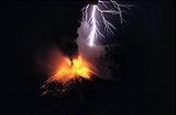
In December 2010, a photo of eruption of Rinjani won 2010 National Geographic Photography Contest. The photo, taken by Singaporean photographer Aaron Lim Boon Teck won the contest, and described by the judge as "best represented the craft of photography
. Not only is the light subtle and beautiful, and not only is it a lovely scene, but there's a volcanic eruption going on in the background."
Volcano
2. Bedrock3. Conduit 4. Base5. Sill6. Dike7. Layers of ash emitted by the volcano8. Flank| 9. Layers of lava emitted by the volcano10. Throat11. Parasitic cone12. Lava flow13. Vent14. Crater15...
in Indonesia
Indonesia
Indonesia , officially the Republic of Indonesia , is a country in Southeast Asia and Oceania. Indonesia is an archipelago comprising approximately 13,000 islands. It has 33 provinces with over 238 million people, and is the world's fourth most populous country. Indonesia is a republic, with an...
on the island of Lombok
Lombok
Lombok is an island in West Nusa Tenggara province, Indonesia. It forms part of the chain of the Lesser Sunda Islands, with the Lombok Strait separating it from Bali to the west and the Alas Strait between it and Sumbawa to the east...
. Administratively the mountain is in the Regency of North Lombok
North Lombok Regency
North Lombok Regency is a Kabupaten of the Indonesian Province of West Nusa Tenggara. It is located on the island of Lombok and the capital is Tanjung situated on the north west coast of the island....
, West Nusa Tenggara
West Nusa Tenggara
West Nusa Tenggara is a province in south-central Indonesia. The province encompasses the western portion of the Lesser Sunda Islands, except for Bali as the Wallace line running the length of the Lombok Strait forms the western boundary of the province....
(Indonesian
Indonesian language
Indonesian is the official language of Indonesia. Indonesian is a normative form of the Riau Islands dialect of Malay, an Austronesian language which has been used as a lingua franca in the Indonesian archipelago for centuries....
: Nusa Tenggara Barat, NTB). It rises to 3726 metres (12,224 ft), making it the second highest volcano in Indonesia.
On the top of the volcano is a 6 km by 8.5 km caldera
Caldera
A caldera is a cauldron-like volcanic feature usually formed by the collapse of land following a volcanic eruption, such as the one at Yellowstone National Park in the US. They are sometimes confused with volcanic craters...
, which is filled partially by the crater lake
Crater lake
A crater lake is a lake that forms in a volcanic crater or caldera, such as a maar; less commonly and with lower association to the term a lake may form in an impact crater caused by a meteorite. Sometimes lakes which form inside calderas are called caldera lakes, but often this distinction is not...
known as Segara Anak (Child of the Sea). This lake is approximately 2000 metres above sea level and estimated at being around 200 metres deep; the caldera also contains hot springs
Hot Springs
Hot Springs may refer to:* Hot Springs, Arkansas** Hot Springs National Park, Arkansas*Hot Springs, California**Hot Springs, Lassen County, California**Hot Springs, Modoc County, California**Hot Springs, Placer County, California...
.
Geography
Lombok is one of the Lesser Sunda IslandsLesser Sunda Islands
The Lesser Sunda Islands or Nusa Tenggara are a group of islands in the southern Maritime Southeast Asia, north of Australia. Together with the Greater Sunda Islands to the west they make up the Sunda Islands...
, a small archipelago
Archipelago
An archipelago , sometimes called an island group, is a chain or cluster of islands. The word archipelago is derived from the Greek ἄρχι- – arkhi- and πέλαγος – pélagos through the Italian arcipelago...
which, from west to east, consists of Bali
Bali
Bali is an Indonesian island located in the westernmost end of the Lesser Sunda Islands, lying between Java to the west and Lombok to the east...
, Lombok
Lombok
Lombok is an island in West Nusa Tenggara province, Indonesia. It forms part of the chain of the Lesser Sunda Islands, with the Lombok Strait separating it from Bali to the west and the Alas Strait between it and Sumbawa to the east...
, Sumbawa
Sumbawa
Sumbawa is an Indonesian island, located in the middle of the Lesser Sunda Islands chain, with Lombok to the west, Flores to the east, and Sumba further to the southeast. It is in the province of West Nusa Tenggara....
, Flores
Flores
Flores is one of the Lesser Sunda Islands, an island arc with an estimated area of 14,300 km² extending east from the Java island of Indonesia. The population was 1.831.000 in the 2010 census and the largest town is Maumere. Flores is Portuguese for "flowers".Flores is located east of Sumbawa...
, Sumba
Sumba
Sumba is an island in eastern Indonesia, is one of the Lesser Sunda Islands, and is in the province of East Nusa Tenggara. Sumba has an area of 11,153 km², and the population was officially at 611,422 in 2005...
and the Timor
Timor
Timor is an island at the southern end of Maritime Southeast Asia, north of the Timor Sea. It is divided between the independent state of East Timor, and West Timor, belonging to the Indonesian province of East Nusa Tenggara. The island's surface is 30,777 square kilometres...
islands; all are located at the edge of the Australian continental shelf
Continental shelf
The continental shelf is the extended perimeter of each continent and associated coastal plain. Much of the shelf was exposed during glacial periods, but is now submerged under relatively shallow seas and gulfs, and was similarly submerged during other interglacial periods. The continental margin,...
. Volcanoes in the area are formed due to the action of oceanic crust
Oceanic crust
Oceanic crust is the part of Earth's lithosphere that surfaces in the ocean basins. Oceanic crust is primarily composed of mafic rocks, or sima, which is rich in iron and magnesium...
s and the movement of the shelf itself. Rinjani is one of at least 129 active volcanoes in Indonesia, four of which belong to the volcanoes of the Sunda Arc
Sunda Arc
The Sunda Arc is a volcanic arc that has produced the islands of Sumatra and Java, the Sunda Strait and the Lesser Sunda Islands. A chain of volcanoes forms the topographic spine of these islands...
trench system forming part of the Pacific Ring of Fire
Pacific Ring of Fire
The Pacific Ring of Fire is an area where large numbers of earthquakes and volcanic eruptions occur in the basin of the Pacific Ocean. In a horseshoe shape, it is associated with a nearly continuous series of oceanic trenches, volcanic arcs, and volcanic belts and/or plate movements...
– a section of fault lines stretching from the Western Hemisphere
Western Hemisphere
The Western Hemisphere or western hemisphere is mainly used as a geographical term for the half of the Earth that lies west of the Prime Meridian and east of the Antimeridian , the other half being called the Eastern Hemisphere.In this sense, the western hemisphere consists of the western portions...
through Japan
Japan
Japan is an island nation in East Asia. Located in the Pacific Ocean, it lies to the east of the Sea of Japan, China, North Korea, South Korea and Russia, stretching from the Sea of Okhotsk in the north to the East China Sea and Taiwan in the south...
and South East Asia.
The islands of Lombok and Sumbawa lie in the central portion of the Sunda Arc. The Sunda Arc is home to some of the world's most dangerous and explosive volcanoes. The eruption of nearby Mount Tambora
Mount Tambora
Mount Tambora is an active stratovolcano, also known as a composite volcano, on the island of Sumbawa, Indonesia. Sumbawa is flanked both to the north and south by oceanic crust, and Tambora was formed by the active subduction zone beneath it. This raised Mount Tambora as high as , making it...
on Sumbawa is known for the most violent eruption in recorded history on 15 April 1815, with a scale 7 on the VEI
Volcanic Explosivity Index
The Volcanic Explosivity Index was devised by Chris Newhall of the U.S. Geological Survey and Stephen Self at the University of Hawaii in 1982 to provide a relative measure of the explosiveness of volcanic eruptions....
.
The highland
Highland (geography)
The term highland or upland is used to denote any mountainous region or elevated mountainous plateau. Generally speaking, the term upland tends to be used for ranges of hills, typically up to 500-600m, and highland for ranges of low mountains.The Scottish Highlands refers to the mountainous...
s are forest clad and mostly undeveloped. The lowland
Lowland
In physical geography, a lowland is any broad expanse of land with a general low level. The term is thus applied to the landward portion of the upward slope from oceanic depths to continental highlands, to a region of depression in the interior of a mountainous region, to a plain of denudation, or...
s are highly cultivated. Rice
Rice
Rice is the seed of the monocot plants Oryza sativa or Oryza glaberrima . As a cereal grain, it is the most important staple food for a large part of the world's human population, especially in East Asia, Southeast Asia, South Asia, the Middle East, and the West Indies...
, soybean
Soybean
The soybean or soya bean is a species of legume native to East Asia, widely grown for its edible bean which has numerous uses...
s, coffee
Coffee
Coffee is a brewed beverage with a dark,init brooo acidic flavor prepared from the roasted seeds of the coffee plant, colloquially called coffee beans. The beans are found in coffee cherries, which grow on trees cultivated in over 70 countries, primarily in equatorial Latin America, Southeast Asia,...
, tobacco
Tobacco
Tobacco is an agricultural product processed from the leaves of plants in the genus Nicotiana. It can be consumed, used as a pesticide and, in the form of nicotine tartrate, used in some medicines...
, cotton
Cotton
Cotton is a soft, fluffy staple fiber that grows in a boll, or protective capsule, around the seeds of cotton plants of the genus Gossypium. The fiber is almost pure cellulose. The botanical purpose of cotton fiber is to aid in seed dispersal....
, cinnamon
Cinnamon
Cinnamon is a spice obtained from the inner bark of several trees from the genus Cinnamomum that is used in both sweet and savoury foods...
, cacao, cloves, cassava
Cassava
Cassava , also called yuca or manioc, a woody shrub of the Euphorbiaceae native to South America, is extensively cultivated as an annual crop in tropical and subtropical regions for its edible starchy tuberous root, a major source of carbohydrates...
, corn
Maize
Maize known in many English-speaking countries as corn or mielie/mealie, is a grain domesticated by indigenous peoples in Mesoamerica in prehistoric times. The leafy stalk produces ears which contain seeds called kernels. Though technically a grain, maize kernels are used in cooking as a vegetable...
, coconuts
COcOnuts
COcOnuts is the second album released by Jane, comprising Animal Collective member Panda Bear, and Scott Mou. It was originally self-released on CD-R's, but later became the first album released by Psych-o-path Records in 2005. The Psych-o-path version was remastered by Rusty Santos and Edik Kleyner....
, copra
Copra
Copra is the dried meat, or kernel, of the coconut. Coconut oil extracted from it has made copra an important agricultural commodity for many coconut-producing countries. It also yields coconut cake which is mainly used as feed for livestock.-Production:...
, bananas and vanilla
Vanilla
Vanilla is a flavoring derived from orchids of the genus Vanilla, primarily from the Mexican species, Flat-leaved Vanilla . The word vanilla derives from the Spanish word "", little pod...
are the major crops grown in the fertile soils of the island. The slopes are populated by the indigenous
Indigenous peoples
Indigenous peoples are ethnic groups that are defined as indigenous according to one of the various definitions of the term, there is no universally accepted definition but most of which carry connotations of being the "original inhabitants" of a territory....
Sasak
Sasak
The Sasak live mainly on the island of Lombok, Indonesia, numbering around 2.6 million . They are related to the Balinese in language and race, although the Sasak are predominantly Muslim while the Balinese are Hindu....
population. There are also some basic tourist related activities established on Rinjani primarily in or about the village of Senaru.
Rinjani volcano on the island of Lombok rises to 3726 metres (12,224.4 ft), second in height among Indonesian volcanoes only to Sumatra
Sumatra
Sumatra is an island in western Indonesia, westernmost of the Sunda Islands. It is the largest island entirely in Indonesia , and the sixth largest island in the world at 473,481 km2 with a population of 50,365,538...
's Kerinci
Mount Kerinci
Mount Kerinci is the highest volcano in Indonesia, and the highest peak on the island of Sumatra...
volcano. Rinjani has a steep-sided conical profile when viewed from the east, but the western side of the compound volcano is truncated by the 6 x 8.5 km, oval-shaped Segara Anak caldera. The western half of the caldera contains a 230 metre-deep lake whose crescentic form results from growth of the post-caldera cone Barujari at the eastern end of the caldera.
Geologic summary
On the basis of Plate TectonicPlate tectonics
Plate tectonics is a scientific theory that describes the large scale motions of Earth's lithosphere...
s Theory, Rinjani is one of the series of volcanoes built in the Lesser Sunda Islands due to the subduction of Indo-Australian oceanic crust beneath the Lesser Sunda Islands, and it is interpreted that the sources of melted magma is at about 165–200 km depth.
The geology and tectonic setting of Lombok (and nearby Sumbawa
Sumbawa
Sumbawa is an Indonesian island, located in the middle of the Lesser Sunda Islands chain, with Lombok to the west, Flores to the east, and Sumba further to the southeast. It is in the province of West Nusa Tenggara....
) are described as being in the central portion of the Sunda Arc
Sunda Arc
The Sunda Arc is a volcanic arc that has produced the islands of Sumatra and Java, the Sunda Strait and the Lesser Sunda Islands. A chain of volcanoes forms the topographic spine of these islands...
. The oldest exposed rocks are Miocene
Miocene
The Miocene is a geological epoch of the Neogene Period and extends from about . The Miocene was named by Sir Charles Lyell. Its name comes from the Greek words and and means "less recent" because it has 18% fewer modern sea invertebrates than the Pliocene. The Miocene follows the Oligocene...
, suggesting that subduction and volcanism began considerably later than in Java and Sumatra to the west, where there are abundant volcanic and intrusive rocks of Late Mesozoic age. The islands are located on the eastern edge of the Sunda shelf, in a zone where crustal thickness is apparently rapidly diminishing, from west to east.
The seismic velocity structure of the crust in this region is transitional between typical oceanic and continental profiles and the Mohorovičić discontinuity
Mohorovičić discontinuity
The Mohorovičić discontinuity , usually referred to as the Moho, is the boundary between the Earth's crust and the mantle. Named after the pioneering Croatian seismologist Andrija Mohorovičić, the Moho separates both the oceanic crust and continental crust from underlying mantle...
(Moho) appears to lie at about 20 km. These factors tend to suggest that there has been limited opportunity for crustal contamination of magmas erupted on the islands of Lombok and Sumbawa. In addition, these islands lie to the west of those parts of the eastern-most Sunda and west Banda arcs where collision with the Australian plate
Indo-Australian Plate
The Indo-Australian Plate is a major tectonic plate that includes the continent of Australia and surrounding ocean, and extends northwest to include the Indian subcontinent and adjacent waters...
is apparently progressing.
The volcano of Rinjani is be located between 165 and 190 km above the Benioff Zone
Benioff zone
A Wadati–Benioff zone is a deep active seismic area in a subduction zone. Differential motion along the zone produces deep-seated earthquakes, the foci of which may be as deep as about . They develop beneath volcanic island arcs and continental margins above active subduction zones...
. There is a marked offset in the line of active volcanoes between the most easterly Sumbawa Volcano (Sangeang Api) and the line of active volcano in the Flores. This suggests that a major transcurrent fault cut across the arc between Sumbawa Island and Flores. This is considered to be a feature representing a major tectonic discontinuity between the east and west Sunda Arcs (the Sumba Fracture). Further. A marked absence of shallow and intermediate earthquake activity in the region to the south of Lombok and Sumbawa is a feature interpreted to represent a marked break in the Sunda Arc Zone. Faulting and folding caused strong deformation in the eastern part of Lombok Basin and is characterized by block faulting, shale diapirs and mud volcano.
Volcanology
Caldera
A caldera is a cauldron-like volcanic feature usually formed by the collapse of land following a volcanic eruption, such as the one at Yellowstone National Park in the US. They are sometimes confused with volcanic craters...
forming eruption is thought to have occurred in the 13th century. Eruption rate, eruption sites, eruptiion type and magma
Magma
Magma is a mixture of molten rock, volatiles and solids that is found beneath the surface of the Earth, and is expected to exist on other terrestrial planets. Besides molten rock, magma may also contain suspended crystals and dissolved gas and sometimes also gas bubbles. Magma often collects in...
composition have changed during the last 10,000 years before the caldera forming eruption. The eruptions of 1994 and 1995 have presented at Gunung Baru (or 'New Mountain' - approximately 2300 metre above sea level) in the center of this caldera and lava flows from subsequent eruptions have entered the lake. This cone has since been renamed Gunung Barujari (or 'Gunung Baru Jari' in Indonesian).
The first historical eruption occurred in September 1847. The most recent eruption of Mount Rinjani was in May 2010 and the most recent significant eruptions occurred during a spate of activity from 1994 to 1995 which resulted in the further development of Gunung Barujari. Historical eruptions at Rinjani dating back to 1847 have been restricted to Barujari cone and the Rombongan dome (in 1944) and consist of moderate explosive activity and occasional lava
Lava
Lava refers both to molten rock expelled by a volcano during an eruption and the resulting rock after solidification and cooling. This molten rock is formed in the interior of some planets, including Earth, and some of their satellites. When first erupted from a volcanic vent, lava is a liquid at...
flows that have entered Segara Anak lake. The eruptive history of Rinjani prior to 1847 is not available as the island of Lombok is in a location that remained very remote to the record keeping of the era.
On 3 November 1994, a cold lahar
Lahar
A lahar is a type of mudflow or debris flow composed of a slurry of pyroclastic material, rocky debris, and water. The material flows down from a volcano, typically along a river valley. The term is a shortened version of "berlahar" which originated in the Javanese language of...
(volcanic mudflow) from the summit area of Rinjani volcano traveled down the Kokok Jenggak River killing thirty people from the village of Aikmel who were caught by surprise when collecting water from the river in the path of the flow.
In connection with the eruption of the cone Gunung Barujari the status for Gunung Rinjani has been raised from Normal (VEI
Volcanic Explosivity Index
The Volcanic Explosivity Index was devised by Chris Newhall of the U.S. Geological Survey and Stephen Self at the University of Hawaii in 1982 to provide a relative measure of the explosiveness of volcanic eruptions....
Level 1) to 'be vigilant' (VEI Level 2) since May 2, 2009 . In May 2010 Gunung Rinjani was placed in the standby status by Center for Volcanology & Geological Hazard Mitigation, Indonesia with a recommendation that there be no activity within a radius of 4 km from the eruption at Gunung Barujari.
Volcanic composition
In Lombok, Rinjani volcano lies approximately 300 km north of the Sunda Trench (also known as Java trench) and is situated about 170 km above the active north dipping Benioff zoneBenioff zone
A Wadati–Benioff zone is a deep active seismic area in a subduction zone. Differential motion along the zone produces deep-seated earthquakes, the foci of which may be as deep as about . They develop beneath volcanic island arcs and continental margins above active subduction zones...
. Based on the composition of andesites
Andesites
Andesites is an extinct genus of cephalopod belonging to the Ammonite subclass....
which have very low Ni concentrations and low Mg/Mg+Fe It is suggested that the Rinjani suite is of mantle
Mantle (geology)
The mantle is a part of a terrestrial planet or other rocky body large enough to have differentiation by density. The interior of the Earth, similar to the other terrestrial planets, is chemically divided into layers. The mantle is a highly viscous layer between the crust and the outer core....
origin, but that all the andesites and dacite
Dacite
Dacite is an igneous, volcanic rock. It has an aphanitic to porphyritic texture and is intermediate in composition between andesite and rhyolite. The relative proportions of feldspars and quartz in dacite, and in many other volcanic rocks, are illustrated in the QAPF diagram...
s as well as many of the basalt
Basalt
Basalt is a common extrusive volcanic rock. It is usually grey to black and fine-grained due to rapid cooling of lava at the surface of a planet. It may be porphyritic containing larger crystals in a fine matrix, or vesicular, or frothy scoria. Unweathered basalt is black or grey...
s have probably been modified by fractional crystallization
Fractional crystallization (geology)
Fractional crystallization is one of the most important geochemical and physical processes operating within the Earth's crust and mantle. Fractional crystallization is the removal and segregation from a melt of mineral precipitates; except in special cases, removal of the crystals changes the...
processes. It is concluded that the Rinjani calc-alkaline suite, which in many respects is typical of many suites erupted by circum-pacific volcanoes, probably originated by partial melting of the peridotite
Peridotite
A peridotite is a dense, coarse-grained igneous rock, consisting mostly of the minerals olivine and pyroxene. Peridotite is ultramafic, as the rock contains less than 45% silica. It is high in magnesium, reflecting the high proportions of magnesium-rich olivine, with appreciable iron...
mantle-wedge overlying the active Benioff Zone beneath Lombok Island. The Pleistocene-Recent calcalkaline suite from the active volcano, Rinjani is composed of a diverse range of lavas. These include: ankaramite, high-Al basalt, andesite, high-K andesite and dacite. Sr-isotopic and geochemical constraints suggest that this suite was derived from the sub-arc mantle. Geochemical models suggest that fractional crystallization is an important process in the suite's differentiation, although the series: ankaramite-high-Al basalt-andesite-dacite does not represent a continuously evolving spectrum of liquids.
Recent activity
Rinjani erupted three times on May 22, 2010 with activity continuing until early on May 23. According to the volcano's official monitoring agency, ash from Mount Barujari was reported as rising up to two km into the atmosphere and damaged crops. The volcano did not threaten villagers at that time. Lava flowed into the caldera lake, pushing its temperature up from 21°C to 35°C, while smoke spread 12 km.In February 2010 observers at the Gunung Rinjani Observation Post located 12.5 km (4000 feet) NE northeast of G. Rinjani saw one whitish-colored plume that rose 100 metres (328 ft) from the volcano. Dense whitish plumes (and possibly brown) rose 500 metres (1,640 ft) - 900 metres (2,953 ft) in March 2010 on 26 occasions and as high as 1500 metres (4,921 ft) in April 2010 on 41 occasions. Plumes seen on 1 and 2 May 2010 were "chocolate" in color and rose a maximum height of 1600 metres (5,249 ft). From February 2010 through April 2010 seismicity decreased, although the maximum amplitude of earthquakes increased. CVGHM (Center of Volcanology and Geological Hazard Mitigation) also noted that ash eruptions and ejected incandescent material fell within Rinjani caldera, but some ash was blown out of the caldera.
The activity in early 2010 centred about Gunung Barujari a post-caldera cone that lies within the Rinjani's caldera lake of Segara Anak. The Volcanological Survey of Indonesia reported on 1 May 2010, that a column of smoke was observed rising from G. Rinjani "issuing eruptions 1300-1600 metres tall with thick brown color and strong pressure". Their report Evaluasi Kegiatan G. Rinjani of 4 May also stated that on 1 May 2010 at 10:00 four events of Explosve Earthquake were recorded with a maximum amplitude of 6–53 mm and 110 seconds long earthquake, earthquake tremor events with a maximum amplitude of 1 mm and 55 second long duration, 15 Local Tectonic earthquake events and two events of tectonic earthquake.
The Volcanic Explosivity Index
Volcanic Explosivity Index
The Volcanic Explosivity Index was devised by Chris Newhall of the U.S. Geological Survey and Stephen Self at the University of Hawaii in 1982 to provide a relative measure of the explosiveness of volcanic eruptions....
(VEI) Alert Level was raised to 2 (on a scale of 1-4) on 2 May 2010. Level 1 is "Normal" and Level 2 is "Advisory" with an Aviation Alert color of Yellow-Advisory. Based on analysis of satellite imagery, the Darwin VAAC (Volcanic Ash Advisory Center) reported that on 5 May a possible ash plume from Rinjani rose to an altitude of 5.5 km (18,000 ft) a.s.l. and drifted 150 km NW. The plume was not seen in imagery about six hours later. CVGHM (Center of Volcanology and Geological Hazard Mitigation) advised the VAAC that intermittent activity could produce ash plumes to 1.5 km (5,000 ft) above the caldera.
On 27 April 2009 Gunung Barujari became active with activity continuing through to May 2009. The mountain was closed at that time as the eruptions intensified with plumes of smoke and ash as high as 8000 m (26,246.7 ft). A Volcanic Explosivity Index (VEI):2 rating was issued for the activity between 2 May 2009 and 20 December 2009. The activity during this period was described as having the characteristics:of central vent eruption, flank (excentric) vent, explosive eruption
Explosive eruption
An explosive eruption is a volcanic term to describe a violent, explosive type of eruption. Mount St. Helens in 1980 was an example. Such an eruption is driven by gas accumulating under great pressure. Driven by hot rising magma, it interacts with ground water until the pressure increases to the...
and lava flow(s).
- See table below for #Eruption history of Rinjani.
Previous activity
On 27 September 2004 a DVGHM (Directorate of Volcanology and Geological Hazard Mitigation) report noted the decision to increase Rinjani's hazard status to Volcanic Explosivity Index (VEI) Alert Level 2 (Yellow). During the last third of 2004, the number of volcanic and tectonic earthquakes had increased. Their increase followed a rise in the number of tectonic earthquakes that began 18 August 2004. Tremor registered on 23, 24, 25, and 26 September 2004. Tremor amplitudes ranged between 12 and 13.5 mm, and the duration of the tremor stood between 94 and 290 seconds.In September 1995 an aviation report was issued concerning an unconfirmed ash cloud from Rinjani. A NOTAM
NOTAM
NOTAM or NoTAM is the quasi-acronym for a "Notice To Airmen". NOTAMs are created and transmitted by government agencies and airport operators under guidelines specified by Annex 15: Aeronautical Information Services of the Convention on International Civil Aviation...
about volcanic activity from Rinjani was issued by the Bali Flight Information Region on the morning of 12 September. An ash cloud was reportedly drifting to the south west with the cloud top around 4 km altitude.
On 3 November 1994, a cold lahar
Lahar
A lahar is a type of mudflow or debris flow composed of a slurry of pyroclastic material, rocky debris, and water. The material flows down from a volcano, typically along a river valley. The term is a shortened version of "berlahar" which originated in the Javanese language of...
(volcanic mudflow) from the summit area of Rinjani volcano traveled down the Kokok Jenggak River killing thirty people from the village of Aikmel who were caught by surprise when collecting water from the river in the path of the flow. One person remained missing as of 9 November 1994. No damage to the village was reported. Local volcanologists noted that additional
lahars could be triggered by heavy rainfall.
During 4 June 1994-January 1995 the DVGHM (Directorate of Volcanology and Geological Hazard Mitigation) noted that explosions occurred on Rinjani. Those explosions came from the Barujari volcano.
At 0530 on 1 October 2004 Rinjani erupted. The eruption caused authorities to immediately raise the hazard status to Alert Level 3 (Orange). Details regarding the initial 1 October 2004 eruption are indistinct. During 2–5 October 2004 explosions sent ash columns ~300 to 800 metres above the summit. Gray, thick ash columns drifted to the north and detonation sounds accompanied every explosion. Successive explosions occurred at intervals of 5 to 160 minutes. Explosions vented on the north eastern slope of Barujari volcano. Some material also vented from Barujari's peak and fell down around its edifice. A press report in the Jakarta Post indicated that evacuations were not considered necessary. A Volcanic Explosivity Index (VEI):2 rating was issued for the activity between 1 May 2004 through to (on or after) 5 October 2004.
Between 3 June 1994 and 21 November 1994 records of Rinjani's eruptive history indicate activity accorded Volcanic Explosivity Index (VEI) with a rating of 3(?) with the area of activity described as Gunung Barujari. Eruptive characteristics documented for the events of that time are described as, central vent eruption with an explosive eruption, with pyroclastic flow
Pyroclastic flow
A pyroclastic flow is a fast-moving current of superheated gas and rock , which reaches speeds moving away from a volcano of up to 700 km/h . The flows normally hug the ground and travel downhill, or spread laterally under gravity...
(s), lava flow(s), fatalities and mudflow
Mudflow
A mudslide is the most rapid and fluid type of downhill mass wasting. It is a rapid movement of a large mass of mud formed from loose soil and water. Similar terms are mudflow, mud stream, debris flow A mudslide is the most rapid (up to 80 km/h, or 50 mph) and fluid type of downhill mass...
(s) (lahars).
In May 1994 a glow was noticed on the crater floor of Barujari cone, which at this time had undergone no significant activity since August 1966. A portable seismograph (PS-2) and telemetry seismograph (Teledyne) were put into operation on 27 May and 9 June, respectively. One volcanic earthquake event/day was recorded on 27, 28, 30, and 31 May. After 4 June, however, volcanic tremor with a maximum amplitude of 35 mm was recorded, presumably associated with the upward movement of magma.
At 0200 on 3 June1994, Barujari cone began erupting by sending an ash plume 500 m high. One 8 June 1994 press report described emission of "smoldering lava" and "thick smoke," as well as ashfall in nearby villages from an ash cloud rising 1,500 m above the summit. Between 3 and 10 June 1994, up to 172 explosions could be heard each day from the Sembalun Lawang volcano observatory (~15 km NE). During this period, seismic data indicated a dramatic increase in the number of explosions per day, from 68 to 18,720. Eruptions were continuous at least through 19 June 1994, with maximum ash plume heights of 2,000 m on 9–11 June 1994.
Between 28 March 1966 and 8 August 1966 records of Rinjani's eruptive history indicate activity accorded a Volcanic Explosivity Index (VEI) rating of 1.
Lava volume of 6.6 x 10⁶ m3 and a tephra volume of 2 x 10⁴ m3 was recorded. The area of activity described was the east side of Barujari (2250 m). Eruptive characteristics were documented as a central vent eruption, explosive eruption and lava flow(s).
In December 1944 Rinjani appears to have had a significant event. Between December 25, 1944 and 1(?) January 1945 eruptive activity is rated 2 on the Volcanic Explosivity Index (VEI) The event has been listed in the historical records of the Global Volcanism Program
Global Volcanism Program
The Smithsonian Institution's Global Volcanism Program documents Earth's volcanoes and their eruptive history over the past 10,000 years. The GVP reports on current eruptions from around the world as well as maintaining a database repository on active volcanoes and their eruptions. In this way, a...
indicating a lava volume: of 7.4 x 10⁷ m3 occurring in an area of activity on the north west flank of Barujari (Rombongan). The eruptive characteristics are described a central vent eruption on the flank (excentric) vent, a crater lake eruption, explosive eruption, lava flow(s) and a lava dome extrusion with associated damage to land, property.
- See table below for #Eruption history of Rinjani.
Monitoring program
Gunung Rinjani Observation Post Rinjani Sembalun is located in the village of Lawang, Sub Sembalun 12.5 km (4000 feet) northeast of G. Rinjani) in the Regency of East LombokEast Lombok Regency
East Lombok Regency is a division of the Indonesian Province of West Nusa Tenggara. It is located on the island of Lombok and the capital is Selong.- Location :To the north lies the Java Sea. To the west is Central Lombok Regency...
. Observers at this post monitor G.Rinjani, G.Barujari/G.Tenga within the Segara Anak Caldera.
Rinjani National Park
The volcano and the caldera are protected by the Gunung Rinjani National ParkGunung Rinjani National Park
Gunung Rinjani National Park is located on the island of Lombok, Indonesia in the North Lombok Regency. The park covers about 41,330 hectares and consists of mountainous areas...
established in 1997. Tourism is increasingly popular with trekkers able to visit the rim, make their way into the caldera or even to make the more arduous climb to the highest point; fatalities, however, are not uncommon. In July 2009 the summit route was closed due to volcanic activity at that time and subsequently reopened when the activity decreased. During early 2010 up to and including May 2010 access to Rinjani was at times again restricted due to volcanic activity.
The park is popular for mountain climbs and trekking and represents an important nature reserve and water catchement area. The park is officially 41,330 hectares within the park boundaries and includes a further 66,000 hectares of protected forest outside. The mountain and its satellites form the Mount Rinjani National Park (Taman Nasional Gunung Rinjani) - officially 41,000 hectares within the park boundaries and a further 66,000 hectares of protected forest outside. In 2008, the Indonesian government proposed to UNESCO that Mount Rinjani be one of the world's official geoparks. If this was approved by UNESCO
UNESCO
The United Nations Educational, Scientific and Cultural Organization is a specialized agency of the United Nations...
, Mount Rinjani would become the first such geological park in Indonesia.
It has been claimed that the preliminary documentation required for UNESCO registration has not received sufficient support from the Nusa Teggara Barat government offices. Among the requirements to become a geo-park sufficient information must be supplied to show that the location has sufficient and appropriate management, information services, access to educational instruction to facilitate "knowledge-based geotourism
Geotourism
Geotourism is "best practice" tourism that sustains, or even enhances, the geographical character of a place, such as its culture, environment, heritage, and the well-being of its residents....
", the implementation of a sustainable regional economy, biodiversity conservation, and to have established public access to the park area.
Mount Rinjani has obtained the World Legacy Award from Conservation International and Traveller (2004), and was a finalist for Tourism for Tomorrow Awards (2005 dan 2008) from the World Travel Tourism Council (WTTC).
In December 2010, a photo of eruption of Rinjani won 2010 National Geographic Photography Contest. The photo, taken by Singaporean photographer Aaron Lim Boon Teck won the contest, and described by the judge as "best represented the craft of photography
Photography
Photography is the art, science and practice of creating durable images by recording light or other electromagnetic radiation, either electronically by means of an image sensor or chemically by means of a light-sensitive material such as photographic film...
. Not only is the light subtle and beautiful, and not only is it a lovely scene, but there's a volcanic eruption going on in the background."
Eruption history of Rinjani
| VEI Volcanic Explosivity Index The Volcanic Explosivity Index was devised by Chris Newhall of the U.S. Geological Survey and Stephen Self at the University of Hawaii in 1982 to provide a relative measure of the explosiveness of volcanic eruptions.... |
Lava Volume | Tephra Volume | Area of Activity | Eruptive Characteristics | Note | |
|---|---|---|---|---|---|---|
| 2 | 2010 February |
Gunung Barujari | Smoke Plumes possible ash plume rose to an altitude of 5.5 km |
SI / USGS Weekly Volcanic Report-Rinjani ABC Asia Pacific News Service 24 may2010 |
||
| 2 | 2009 May 2 |
NE flank of | Historical Records GVP-Rinjani |
|||
| 2 | 2004 Oct 1 |
Summit and NE flank of | Historical Records GVP-Rinjani |
|||
| 0 | 1995 Sep 12 | Explosive eruption (?) | Historical Records GVP-Rinjani |
|||
| 3? | 1994 Jun 3 |
Gunung Barujar | Central vent eruption | Historical Records GVP-Rinjani |
||
| 1 | 1966 Mar 28 |
6.6 x | 2 x | Eastern side of | Central vent eruption | Historical Records GVP-Rinjani |
| 0? | 1965 Sep |
Gunung Barujari | Flank (excentric) vent eruption |
Historical Records GVP-Rinjani |
||
| 0? | 1953 Oct 15 (end) Unknown |
Gunung Barujari | Central vent eruption | Historical Records GVP-Rinjani |
||
| 0? | 1949 1950 |
NW flank of Gunung Barujari | Central vent eruption | Historical Records GVP-Rinjani |
||
| 2 | 1944 Dec 25 |
7.4 x | NW flank of Barujari (Rombongan) | Historical Records GVP-Rinjani |
||
| 0 | 1941 May 30 |
Rinjani summit | Central vent eruption | Historical Records GVP-Rinjani |
||
| 2 | 1915 Nov 4 |
Gunung Barujari (Segara Munjar) |
Central vent eruption | Historical Records GVP-Rinjani |
||
| 2 | 1909 Nov 30 |
Gunung Barujari | |
Historical Records GVP-Rinjani |
||
| 1 | 1906 Apr 29 |
Gunung Barujari | Central vent eruption Explosive eruption | Historical Records GVP-Rinjani |
||
| 2 | 1901 Jun 1 |
Gunung Barujari | Central vent eruption Explosive eruption | Historical Records GVP-Rinjani |
||
| 2 | 1900 Nov 30 1900 Dec 2 |
Gunung Barujari | Central vent eruption | Historical Records GVP-Rinjani |
||
| 2 | 1884 Aug 8 1884 Aug 10 |
Gunung Barujari | Central vent eruption | Historical Records GVP-Rinjani |
||
| 2 | 1847 Sep 10 1847 Sep 12 |
Gunung Barujari | Central vent eruption | Historical Records GVP-Rinjani |
||
| n/a | 13th century (?) exact date unknown |
Gunbung Rinjani | Possible caldera forming eruption | Speculative date Refer to scientific literature |
||
External links
- Global Volcanism Program Rinjani Information page with links to Eruptive History, Photos, Compilation of synonyms and selected subsidiary features of Rinjani
- Bulletin of the Global Volcanism Network, February 2005, Rinjani-Lesser Sunda Islands, Indonesia
- Global Volcanism Program-Rinjani-Index of Monthly Reports
- The Geology of Indonesia-The Lesser Sunda Islands (Wikibooks)
- Gunung Rinjani National Park