
Sumbawa
Encyclopedia
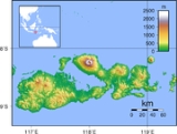
Sumbawa is an Indonesia
n island
, located in the middle of the Lesser Sunda Islands
chain, with Lombok
to the west, Flores
to the east, and Sumba
further to the southeast. It is in the province of West Nusa Tenggara
.
Sumbawa is 15448 km² or 5,964.5 sq mi (three times the size of Lombok
) with a current population of around 1.33 million. It marks the boundary between the islands to the west, which were influenced by religion and culture spreading from India
, and the region to the east that was not so influenced. In particular this applies to both Hinduism and Islam.
of eastern Java. Because of Sumbawa's natural resources it was regularly invaded by outside forces – Japanese, Dutch
, Makassar
ese. The Dutch first arrived in 1605, but did not effectively rule Sumbawa until the early 20th century. The Bali
nese kingdom of Gelgel
ruled western Sumbawa for a short period as well. It was also home to the Sultanate of Bima.
Historical evidence indicates that people on Sumbawa island were known in the East Indies for their honey, horses, sappan wood for producing red dye, and sandalwood used for incense and medications. The area was thought to be highly productive agriculturally.
was introduced via the Makassarese of Sulawesi
.
Sumbawa has historically had two major linguistic groups who spoke languages that were unintelligible to each other. One group centered in the western side of the island speaks Basa Semawa
(Indonesian: Bahasa Sumbawa) which is similar to the Sasak language
from Lombok; the second group in the east speaks Nggahi Mbojo
(Bahasa Bima). They were once separated by the Tambora Kingdom, which spoke a language
related to neither. After the demise of Tambora, the kingdoms located in Sumbawa Besar
and Bima were the two focal points of Sumbawa. This division of the island into two parts remains today; Sumbawa Besar
and Bima
are the two largest towns on the island, and are the centers of distinct cultural groups that share the island.
The population of the island (including minor outliers) was 1.33 million at the latest decennial Census in 2010, comprising 29.58% of the population of the entire province's with 4.5 million people. Due to lack of work opportunities on the island and its frequent drought conditions (unlike wet Bali), many people on the island seek work in the Middle East as laborers or domestic servants; some 500,000 workers, or over 10% of the population of West Nusa Tenggara, have left the country to work overseas.
, south is the Indian Ocean
, Saleh Bay
creates a major north-central indentation in the island, and the Flores Sea
runs the length of the northern coastline. The Sape Strait
lies to the east of the island and separates Sumbawa from Flores
and the Komodo Islands, there are a number bays and gulfs, most notably Bima Bay
, Cempi Bay
, and Waworada Bay
Sumbawa's most distinguishing feature is Saleh Bay and the Tambora Peninsula with Mount Tambora
. Highlands rise in four spots on the island, as well as on Sangeang Island, the large western lobe of Sumbawa is dominated by a large central highland, there is Mt. Tambora, Dompu and Bima each have more minor highlands.
There are a number of large surrounding islands, most notably are Moyo Island
, volcanically active Sangeang Island and the touristic Komodo Islands (administered under Flores) to the east.
. It is a volcanic
island, including Mount Tambora
(8°14’41”S, 117°59’35”E) which exploded in April 1815, the most destructive volcanic eruption in modern history (roughly four times larger than the 1883 eruption of Krakatoa
, between Java and Sumatra
, in terms of volume of magma ejected). The eruption killed as many as 72,000. It also apparently destroyed a small culture of Southeast Asia
n affinity, known to archaeologists as the Tamboran kingdom. It launched 100 cubic kilometres (24 cu mi) of ash into the upper atmosphere, which caused 1816 to be the "year without a summer
". http://news.nationalgeographic.com/news/2006/02/0227_060227_lost_kingdom.html
.
and copper
mine, Newmont's Batu Hijau mine in Sumbawa began commercial operations in 2000, a decade after the copper and gold was discovered. Newmont holds a 45% stake in the operation through its shareholding in PT Newmont Nusa Tenggara. A local unit of Japan's Sumitomo Corporation
has a 35% share.
Newmont and its partners have invested about $1.9 billion in the mine, which has estimated reserves of 1,000 metric tons of copper. The reserves are expected to last until 2034, making Batu Hijau one of the largest copper mines in the world. Newmont has a been involved in scandals of mercury
and arsenic
poisoning in Sulawesi island, as well as having been embroiled in pollution cases on four continents.
) exists, however ferry service to Flores
from Sape
is infrequent. Bima
being the largest city, has ferry and bus service directly to Java
and Bali
, though service breakdowns are common.
Indonesia
Indonesia , officially the Republic of Indonesia , is a country in Southeast Asia and Oceania. Indonesia is an archipelago comprising approximately 13,000 islands. It has 33 provinces with over 238 million people, and is the world's fourth most populous country. Indonesia is a republic, with an...
n island
Island
An island or isle is any piece of sub-continental land that is surrounded by water. Very small islands such as emergent land features on atolls can be called islets, cays or keys. An island in a river or lake may be called an eyot , or holm...
, located in the middle of the Lesser Sunda Islands
Lesser Sunda Islands
The Lesser Sunda Islands or Nusa Tenggara are a group of islands in the southern Maritime Southeast Asia, north of Australia. Together with the Greater Sunda Islands to the west they make up the Sunda Islands...
chain, with Lombok
Lombok
Lombok is an island in West Nusa Tenggara province, Indonesia. It forms part of the chain of the Lesser Sunda Islands, with the Lombok Strait separating it from Bali to the west and the Alas Strait between it and Sumbawa to the east...
to the west, Flores
Flores
Flores is one of the Lesser Sunda Islands, an island arc with an estimated area of 14,300 km² extending east from the Java island of Indonesia. The population was 1.831.000 in the 2010 census and the largest town is Maumere. Flores is Portuguese for "flowers".Flores is located east of Sumbawa...
to the east, and Sumba
Sumba
Sumba is an island in eastern Indonesia, is one of the Lesser Sunda Islands, and is in the province of East Nusa Tenggara. Sumba has an area of 11,153 km², and the population was officially at 611,422 in 2005...
further to the southeast. It is in the province of West Nusa Tenggara
West Nusa Tenggara
West Nusa Tenggara is a province in south-central Indonesia. The province encompasses the western portion of the Lesser Sunda Islands, except for Bali as the Wallace line running the length of the Lombok Strait forms the western boundary of the province....
.
Sumbawa is 15448 km² or 5,964.5 sq mi (three times the size of Lombok
Lombok
Lombok is an island in West Nusa Tenggara province, Indonesia. It forms part of the chain of the Lesser Sunda Islands, with the Lombok Strait separating it from Bali to the west and the Alas Strait between it and Sumbawa to the east...
) with a current population of around 1.33 million. It marks the boundary between the islands to the west, which were influenced by religion and culture spreading from India
India
India , officially the Republic of India , is a country in South Asia. It is the seventh-largest country by geographical area, the second-most populous country with over 1.2 billion people, and the most populous democracy in the world...
, and the region to the east that was not so influenced. In particular this applies to both Hinduism and Islam.
History
Four principalities in western Sumbawa were dependencies of the Majapahit EmpireMajapahit Empire
Majapahit was a vast archipelagic empire based on the island of Java from 1293 to around 1500. Majapahit reached its peak of glory during the era of Hayam Wuruk, whose reign from 1350 to 1389 marked by conquest which extended through Southeast Asia. His achievement is also credited to his prime...
of eastern Java. Because of Sumbawa's natural resources it was regularly invaded by outside forces – Japanese, Dutch
Netherlands
The Netherlands is a constituent country of the Kingdom of the Netherlands, located mainly in North-West Europe and with several islands in the Caribbean. Mainland Netherlands borders the North Sea to the north and west, Belgium to the south, and Germany to the east, and shares maritime borders...
, Makassar
Makassar
Makassar, is the provincial capital of South Sulawesi, Indonesia, and the largest city on Sulawesi Island. From 1971 to 1999, the city was named Ujung Pandang, after a precolonial fort in the city, and the two names are often used interchangeably...
ese. The Dutch first arrived in 1605, but did not effectively rule Sumbawa until the early 20th century. The Bali
Bali
Bali is an Indonesian island located in the westernmost end of the Lesser Sunda Islands, lying between Java to the west and Lombok to the east...
nese kingdom of Gelgel
Gelgel, Indonesia
Gelgel is a village that is situated in the regency of Klungkung, on the Island of Bali, Indonesia. The village, which lies four kilometers south of the regency capital Semarapura, not far from the coast, contains a number of culturally interesting structures. It is known for its pottery and...
ruled western Sumbawa for a short period as well. It was also home to the Sultanate of Bima.
Historical evidence indicates that people on Sumbawa island were known in the East Indies for their honey, horses, sappan wood for producing red dye, and sandalwood used for incense and medications. The area was thought to be highly productive agriculturally.
Administration
Sumbawa is administratively divided into 4 regencies and one kota (city). They are:| Name | Capital | Population 2005 estimate | Population 2010 Census |
|---|---|---|---|
| Sumbawa Regency Sumbawa Regency Sumbawa Regency is a Kabupaten of the Indonesian Province of West Nusa Tenggara. It is located on the island of Sumbawa and the capital is Sumbawa Besar.- References :... |
Sumbawa Besar Sumbawa Besar Sumbawa Besar is one of the most populated towns beside Bima and Dompu in the Indonesian island of Sumbawa. It is the capital city of the island and of the Sumbawa Regency of the province of West Nusa Tenggara.- Name :... |
||
| Dompu Regency Dompu Regency Dompu Regency is a division of the Indonesian Province of West Nusa Tenggara. It is located on the island of Sumbawa and the capital is Dompu. It is bordered to the north and to the east by two non-contiguous parts of Bima Regency, as well as by Saleh Bay, Sanggar Bay, and Cempi Bay.... |
Dompu | ||
| Bima Regency Bima Regency Bima Regency is a division of the Indonesian Province of West Nusa Tenggara. It is located on the island of Sumbawa and the capital is Woha, and it completely surrounds Bima City .... |
Raba Raba Raba can refer to:*Raba, Indonesia, a town on Sumbawa island, Indonesia*Raba , a river in Poland, tributary of the Vistula*Rabbah bar Nahmani, known simply as Rabbah, was a Babylonian rabbi known in the Talmud as an Amora... |
||
| Sumbawa Barat (West Sumbawa) Regency West Sumbawa Regency West Sumbawa Regency is a Kabupaten of the Indonesian Province of West Nusa Tenggara. It is located on the island of Sumbawa and the capital is Taliwang.- References :... |
Taliwang | ||
| Bima Bima Bima is a city on the eastern coast of the island Sumbawa in central Indonesia's province West Nusa Tenggara, and the largest city on the island. In 2010 the municipality counted some 142,443 people, separate from the adjoining Regency of Bima with 407,636 population... City |
Bima Bima Bima is a city on the eastern coast of the island Sumbawa in central Indonesia's province West Nusa Tenggara, and the largest city on the island. In 2010 the municipality counted some 142,443 people, separate from the adjoining Regency of Bima with 407,636 population... |
||
| Totals |
Demographics
IslamIslam
Islam . The most common are and . : Arabic pronunciation varies regionally. The first vowel ranges from ~~. The second vowel ranges from ~~~...
was introduced via the Makassarese of Sulawesi
Sulawesi
Sulawesi is one of the four larger Sunda Islands of Indonesia and is situated between Borneo and the Maluku Islands. In Indonesia, only Sumatra, Borneo, and Papua are larger in territory, and only Java and Sumatra have larger Indonesian populations.- Etymology :The Portuguese were the first to...
.
Sumbawa has historically had two major linguistic groups who spoke languages that were unintelligible to each other. One group centered in the western side of the island speaks Basa Semawa
Sumbawa language
Sumbawa is the language of the western half of Sumbawa Island, Indonesia, which it shares with Bima. It is closely related to the languages of adjacent Lombok and Bali; indeed, it is the westernmost language in the south of Indonesia that is not part of the Central Malayo-Polynesian Sprachbund....
(Indonesian: Bahasa Sumbawa) which is similar to the Sasak language
Sasak language
The Sasak language is spoken by the Sasak ethnic group, which make up the majority of the population of Lombok, Indonesia. It is closely related to the languages of adjacent Bali and Sumbawa....
from Lombok; the second group in the east speaks Nggahi Mbojo
Bima language
The Bima language, or Bimanese, is the language of the eastern half of Sumbawa Island, Indonesia, which it shares with the Sumbawa language. Bima territory includes the Sanggar Peninsula, where the extinct Papuan language Tambora was once spoken. It is closely related to the languages of Sumba...
(Bahasa Bima). They were once separated by the Tambora Kingdom, which spoke a language
Tambora language
Tambora is the poorly attested non-Austronesian language of the Tambora culture of central Sumbawa, in what is now Indonesia, which was wiped out by the 1815 eruption of Mount Tambora...
related to neither. After the demise of Tambora, the kingdoms located in Sumbawa Besar
Sumbawa Besar
Sumbawa Besar is one of the most populated towns beside Bima and Dompu in the Indonesian island of Sumbawa. It is the capital city of the island and of the Sumbawa Regency of the province of West Nusa Tenggara.- Name :...
and Bima were the two focal points of Sumbawa. This division of the island into two parts remains today; Sumbawa Besar
Sumbawa Besar
Sumbawa Besar is one of the most populated towns beside Bima and Dompu in the Indonesian island of Sumbawa. It is the capital city of the island and of the Sumbawa Regency of the province of West Nusa Tenggara.- Name :...
and Bima
Bima
Bima is a city on the eastern coast of the island Sumbawa in central Indonesia's province West Nusa Tenggara, and the largest city on the island. In 2010 the municipality counted some 142,443 people, separate from the adjoining Regency of Bima with 407,636 population...
are the two largest towns on the island, and are the centers of distinct cultural groups that share the island.
The population of the island (including minor outliers) was 1.33 million at the latest decennial Census in 2010, comprising 29.58% of the population of the entire province's with 4.5 million people. Due to lack of work opportunities on the island and its frequent drought conditions (unlike wet Bali), many people on the island seek work in the Middle East as laborers or domestic servants; some 500,000 workers, or over 10% of the population of West Nusa Tenggara, have left the country to work overseas.
Geography
The island is bound by bodies of water; to the west is Alas StraitAlas Strait
Alas Strait separates Lombok and Sumbawa, two islands of Indonesia in West Nusa Tenggara province.The strait was bridged by land until about 14,000 years before present when sea level rose to about 75 meters below present sea level,...
, south is the Indian Ocean
Indian Ocean
The Indian Ocean is the third largest of the world's oceanic divisions, covering approximately 20% of the water on the Earth's surface. It is bounded on the north by the Indian Subcontinent and Arabian Peninsula ; on the west by eastern Africa; on the east by Indochina, the Sunda Islands, and...
, Saleh Bay
Saleh Bay
Saleh Bay is the largest bay in the island of Sumbawa, Indonesia, roughly on the north central part. It is semi enclosed by Moyo Island and the peninsula of Tambora, Sanggar Peninsula. 3 larger islands in the bay are Liang Island, Ngali Island, and Rakit Island. 3 of the 4 regencies of...
creates a major north-central indentation in the island, and the Flores Sea
Flores Sea
The Flores Sea covers 93,000 square miles of water in Indonesia.- Geography :The seas that border the Flores Sea are the Bali Sea , Java Sea , and the Banda Sea ....
runs the length of the northern coastline. The Sape Strait
Sape Strait
The Sape Strait The Sape Strait (Indonesian: Selat Sape) The Sape Strait (Indonesian: Selat Sape) (also Sapie Strait is a strait connecting the Flores Sea to the Sumba Strait. It separates the islands of Sumbawa and Komodo. It joins the Indondesian provinces of West Nusa Tenggara and East Nusa...
lies to the east of the island and separates Sumbawa from Flores
Flores
Flores is one of the Lesser Sunda Islands, an island arc with an estimated area of 14,300 km² extending east from the Java island of Indonesia. The population was 1.831.000 in the 2010 census and the largest town is Maumere. Flores is Portuguese for "flowers".Flores is located east of Sumbawa...
and the Komodo Islands, there are a number bays and gulfs, most notably Bima Bay
Bima Bay
Bima Bay is a major waterway on the north side of the island of Sumbawa, and is adjacent to Bima City and Bima Regency . It contains the island Kambing Island , as well as the Bima harbor .-External links:...
, Cempi Bay
Cempi Bay
Cempi Bay or Cempi Gulf is a bay which borders the southern part of Dompu Regency of Sumbawa island facing the Indian Ocean. It is notable for having a surfing enthusiast spots of Hu'u and Lakey Beach....
, and Waworada Bay
Waworada Bay
Waworada Bay or Waworada Gulf is a slender bay facing the Indian Ocean on Sumbawa island, in Bima Regency, opening towards Sape Strait.-External links:...
Sumbawa's most distinguishing feature is Saleh Bay and the Tambora Peninsula with Mount Tambora
Mount Tambora
Mount Tambora is an active stratovolcano, also known as a composite volcano, on the island of Sumbawa, Indonesia. Sumbawa is flanked both to the north and south by oceanic crust, and Tambora was formed by the active subduction zone beneath it. This raised Mount Tambora as high as , making it...
. Highlands rise in four spots on the island, as well as on Sangeang Island, the large western lobe of Sumbawa is dominated by a large central highland, there is Mt. Tambora, Dompu and Bima each have more minor highlands.
There are a number of large surrounding islands, most notably are Moyo Island
Moyo Island
Moyo is an island in Indonesia's West Nusa Tenggara province. It is off the north coast Sumbawa Island, and has an area of 349 km2....
, volcanically active Sangeang Island and the touristic Komodo Islands (administered under Flores) to the east.
List of Islands
- West Sumbawa Regency
- Susait
- Dua
- Belang
- Songi
- Ular
- Kenawa
- Natano
- Sumbawa Besar Regency
- Panjang Island
- Saringi
- Kemudang
- Ayer Tawat
- Romo
- Medang IslandMedang IslandNot to be confused with Pulau Medang, Senayang, Lingga IslandsMedang Island is an island off the north coast of Sumbawa, west of Moyo Island, in the Flores Sea. It is actually composed of two islands, Medang Besar and Medang Kecil . There are coral reefs in this area, with sharks and giant...
- Saleh BaySaleh BaySaleh Bay is the largest bay in the island of Sumbawa, Indonesia, roughly on the north central part. It is semi enclosed by Moyo Island and the peninsula of Tambora, Sanggar Peninsula. 3 larger islands in the bay are Liang Island, Ngali Island, and Rakit Island. 3 of the 4 regencies of...
, Sumbawa Besar Regency- Moyo IslandMoyo IslandMoyo is an island in Indonesia's West Nusa Tenggara province. It is off the north coast Sumbawa Island, and has an area of 349 km2....
- Dangar Besar
- Liang
- Ngali
- Tengar
- Kelapang
- Dompo
- Takebo
- Paming
- Lipa
- Rakit
- Moyo Island
- Dompu Regency
- P. Besar
- P. Nisa Pudu
- P. Nisa Rate
- Bima Regency, Tambora Peninsula exclave
- Satonda Island
- Bima Regency
- Sangeang Island
- Sanai Island
- Matagate Island
- Banta Island
Volcanoes
Sumbawa lies within the Pacific Ring of FirePacific Ring of Fire
The Pacific Ring of Fire is an area where large numbers of earthquakes and volcanic eruptions occur in the basin of the Pacific Ocean. In a horseshoe shape, it is associated with a nearly continuous series of oceanic trenches, volcanic arcs, and volcanic belts and/or plate movements...
. It is a volcanic
Volcano
2. Bedrock3. Conduit 4. Base5. Sill6. Dike7. Layers of ash emitted by the volcano8. Flank| 9. Layers of lava emitted by the volcano10. Throat11. Parasitic cone12. Lava flow13. Vent14. Crater15...
island, including Mount Tambora
Mount Tambora
Mount Tambora is an active stratovolcano, also known as a composite volcano, on the island of Sumbawa, Indonesia. Sumbawa is flanked both to the north and south by oceanic crust, and Tambora was formed by the active subduction zone beneath it. This raised Mount Tambora as high as , making it...
(8°14’41”S, 117°59’35”E) which exploded in April 1815, the most destructive volcanic eruption in modern history (roughly four times larger than the 1883 eruption of Krakatoa
Krakatoa
Krakatoa is a volcanic island made of a'a lava in the Sunda Strait between the islands of Java and Sumatra in Indonesia. The name is used for the island group, the main island , and the volcano as a whole. The island exploded in 1883, killing approximately 40,000 people, although some estimates...
, between Java and Sumatra
Sumatra
Sumatra is an island in western Indonesia, westernmost of the Sunda Islands. It is the largest island entirely in Indonesia , and the sixth largest island in the world at 473,481 km2 with a population of 50,365,538...
, in terms of volume of magma ejected). The eruption killed as many as 72,000. It also apparently destroyed a small culture of Southeast Asia
Southeast Asia
Southeast Asia, South-East Asia, South East Asia or Southeastern Asia is a subregion of Asia, consisting of the countries that are geographically south of China, east of India, west of New Guinea and north of Australia. The region lies on the intersection of geological plates, with heavy seismic...
n affinity, known to archaeologists as the Tamboran kingdom. It launched 100 cubic kilometres (24 cu mi) of ash into the upper atmosphere, which caused 1816 to be the "year without a summer
Year Without a Summer
The Year Without a Summer was 1816, in which severe summer climate abnormalities caused average global temperatures to decrease by about 0.4–0.7 °C , resulting in major food shortages across the Northern Hemisphere...
". http://news.nationalgeographic.com/news/2006/02/0227_060227_lost_kingdom.html
Economy
Many of the island residents are at risk of starvation when crops fail due to lack of rainfall. The majority of the population works in agriculture. Tourism is very nascent, with a few surf spots renowned for being world class, Sekongkang and Supersuck Beaches near the mine, as well as Hu'u and Lakey Beach in the Gulf of CempiCempi Bay
Cempi Bay or Cempi Gulf is a bay which borders the southern part of Dompu Regency of Sumbawa island facing the Indian Ocean. It is notable for having a surfing enthusiast spots of Hu'u and Lakey Beach....
.
Newmont Mine
The Southwestern extreme portion of Sumbawa is monopolized by American firm Newmont Mining Corporation; a large goldGold
Gold is a chemical element with the symbol Au and an atomic number of 79. Gold is a dense, soft, shiny, malleable and ductile metal. Pure gold has a bright yellow color and luster traditionally considered attractive, which it maintains without oxidizing in air or water. Chemically, gold is a...
and copper
Copper
Copper is a chemical element with the symbol Cu and atomic number 29. It is a ductile metal with very high thermal and electrical conductivity. Pure copper is soft and malleable; an exposed surface has a reddish-orange tarnish...
mine, Newmont's Batu Hijau mine in Sumbawa began commercial operations in 2000, a decade after the copper and gold was discovered. Newmont holds a 45% stake in the operation through its shareholding in PT Newmont Nusa Tenggara. A local unit of Japan's Sumitomo Corporation
Sumitomo Corporation
Sumitomo Corporation is one of the largest worldwide trading company , and is a diversified corporation. Sumitomo is headquartered in the Harumi Island Triton Square Office Tower Y in Chūō, Tokyo, Japan...
has a 35% share.
Newmont and its partners have invested about $1.9 billion in the mine, which has estimated reserves of 1,000 metric tons of copper. The reserves are expected to last until 2034, making Batu Hijau one of the largest copper mines in the world. Newmont has a been involved in scandals of mercury
Mercury (element)
Mercury is a chemical element with the symbol Hg and atomic number 80. It is also known as quicksilver or hydrargyrum...
and arsenic
Arsenic
Arsenic is a chemical element with the symbol As, atomic number 33 and relative atomic mass 74.92. Arsenic occurs in many minerals, usually in conjunction with sulfur and metals, and also as a pure elemental crystal. It was first documented by Albertus Magnus in 1250.Arsenic is a metalloid...
poisoning in Sulawesi island, as well as having been embroiled in pollution cases on four continents.
Transport
There is a road network in Sumbawa, but it is poorly maintained and has long portions of rough gravel. Frequent ferry service to Sumbawa (Poto Tano) from Lombok (Labuhan LombokLabuhan Lombok
Labuhan Lombok is a port town in eastern Lombok, Indonesia, 74 kilometres east of the city of Mataram. True to the name, which means "Port of Lombok", it is best known as the port for ferries to the neighboring island of Sumbawa. The town is also called Tanjung Kayangan. The port is located to the...
) exists, however ferry service to Flores
Flores
Flores is one of the Lesser Sunda Islands, an island arc with an estimated area of 14,300 km² extending east from the Java island of Indonesia. The population was 1.831.000 in the 2010 census and the largest town is Maumere. Flores is Portuguese for "flowers".Flores is located east of Sumbawa...
from Sape
Sape
Sape is a genus of skippers in the family Hesperiidae.-References:*...
is infrequent. Bima
Bima
Bima is a city on the eastern coast of the island Sumbawa in central Indonesia's province West Nusa Tenggara, and the largest city on the island. In 2010 the municipality counted some 142,443 people, separate from the adjoining Regency of Bima with 407,636 population...
being the largest city, has ferry and bus service directly to Java
Java
Java is an island of Indonesia. With a population of 135 million , it is the world's most populous island, and one of the most densely populated regions in the world. It is home to 60% of Indonesia's population. The Indonesian capital city, Jakarta, is in west Java...
and Bali
Bali
Bali is an Indonesian island located in the westernmost end of the Lesser Sunda Islands, lying between Java to the west and Lombok to the east...
, though service breakdowns are common.