

Lesser Sunda Islands
Encyclopedia
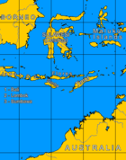
Island
An island or isle is any piece of sub-continental land that is surrounded by water. Very small islands such as emergent land features on atolls can be called islets, cays or keys. An island in a river or lake may be called an eyot , or holm...
s in the southern Maritime Southeast Asia
Maritime Southeast Asia
Maritime Southeast Asia refers to the maritime region of Southeast Asia as opposed to mainland Southeast Asia and includes the modern countries of Indonesia, Malaysia, the Philippines, Brunei, East Timor and Singapore....
, north of Australia
Australia
Australia , officially the Commonwealth of Australia, is a country in the Southern Hemisphere comprising the mainland of the Australian continent, the island of Tasmania, and numerous smaller islands in the Indian and Pacific Oceans. It is the world's sixth-largest country by total area...
. Together with the Greater Sunda Islands
Greater Sunda Islands
The Greater Sunda Islands are a group of large islands within the Malay archipelago. Jawa , smallest but by far the most populous and important; Sumatera in the west, directly across the Strait of Malacca from Malaysia; Kalimantan, the Indonesian sector of large, compact, minicontinent Borneo; and...
to the west they make up the Sunda Islands
Sunda Islands
The Sunda Islands are a group of islands that form part of the Malay archipelago.They are further divided into the Greater Sunda Islands and the Lesser Sunda Islands.-Administration:...
. The islands are part of a volcanic arc
Volcanic arc
A volcanic arc is a chain of volcanoes positioned in an arc shape as seen from above. Offshore volcanoes form islands, resulting in a volcanic island arc. Generally they result from the subduction of an oceanic tectonic plate under another tectonic plate, and often parallel an oceanic trench...
, the Sunda Arc
Sunda Arc
The Sunda Arc is a volcanic arc that has produced the islands of Sumatra and Java, the Sunda Strait and the Lesser Sunda Islands. A chain of volcanoes forms the topographic spine of these islands...
, formed by subduction
Subduction
In geology, subduction is the process that takes place at convergent boundaries by which one tectonic plate moves under another tectonic plate, sinking into the Earth's mantle, as the plates converge. These 3D regions of mantle downwellings are known as "Subduction Zones"...
along the Java Trench
Java Trench
The Sunda Trench, earlier known as, and sometimes still indicated as the Java Trench, located in the northeastern Indian Ocean, with a length of and a maximum depth of , is the second-deepest point in the Indian Ocean after Diamantina Trench, which is 8,047 metres deep...
in the Java Sea
Java Sea
The Java Sea is a large shallow sea on the Sunda Shelf. It was formed as sea levels rose at the end of the last ice age. The Java Sea lies between the Indonesian islands of Borneo to the north, Java to the south; Sumatra to the west, and Sulawesi to the east...
.
Administration
The Lesser Sundas consist of many islands, mostly part of IndonesiaIndonesia
Indonesia , officially the Republic of Indonesia , is a country in Southeast Asia and Oceania. Indonesia is an archipelago comprising approximately 13,000 islands. It has 33 provinces with over 238 million people, and is the world's fourth most populous country. Indonesia is a republic, with an...
. Some of the islands, notably part of Timor
Timor
Timor is an island at the southern end of Maritime Southeast Asia, north of the Timor Sea. It is divided between the independent state of East Timor, and West Timor, belonging to the Indonesian province of East Nusa Tenggara. The island's surface is 30,777 square kilometres...
, are the territory of the state of East Timor
East Timor
The Democratic Republic of Timor-Leste, commonly known as East Timor , is a state in Southeast Asia. It comprises the eastern half of the island of Timor, the nearby islands of Atauro and Jaco, and Oecusse, an exclave on the northwestern side of the island, within Indonesian West Timor...
since its independence in 2002.
The Indonesian part of the Lesser Sunda Islands now make up of three provinces
Provinces of Indonesia
The province is the highest tier of local government subnational entity in Indonesia. Each province has its own local government, headed by a governor, and has its own legislative body...
:
- BaliBaliBali is an Indonesian island located in the westernmost end of the Lesser Sunda Islands, lying between Java to the west and Lombok to the east...
- West Nusa TenggaraWest Nusa TenggaraWest Nusa Tenggara is a province in south-central Indonesia. The province encompasses the western portion of the Lesser Sunda Islands, except for Bali as the Wallace line running the length of the Lombok Strait forms the western boundary of the province....
(Nusa Tenggara Barat) - East Nusa TenggaraEast Nusa TenggaraEast Nusa Tenggara is a province of Indonesia, located in the eastern portion of the Lesser Sunda Islands, including West Timor. The provincial capital is Kupang, located on West Timor...
(Nusa Tenggara Timur)
Geology
The Lesser Sunda Islands consist of two geologically distinct archipelagos. The northern archipelago, which includes BaliBali
Bali is an Indonesian island located in the westernmost end of the Lesser Sunda Islands, lying between Java to the west and Lombok to the east...
, Lombok
Lombok
Lombok is an island in West Nusa Tenggara province, Indonesia. It forms part of the chain of the Lesser Sunda Islands, with the Lombok Strait separating it from Bali to the west and the Alas Strait between it and Sumbawa to the east...
, Sumbawa
Sumbawa
Sumbawa is an Indonesian island, located in the middle of the Lesser Sunda Islands chain, with Lombok to the west, Flores to the east, and Sumba further to the southeast. It is in the province of West Nusa Tenggara....
, Flores
Flores
Flores is one of the Lesser Sunda Islands, an island arc with an estimated area of 14,300 km² extending east from the Java island of Indonesia. The population was 1.831.000 in the 2010 census and the largest town is Maumere. Flores is Portuguese for "flowers".Flores is located east of Sumbawa...
and Wetar
Wetar
The tropical island of Wetar belongs to the Indonesian province of Maluku and is the largest island of the Barat Daya Islands . It lies east of the Lesser Sunda Islands, which include nearby Alor and Timor, but it is politically part of the Maluku Islands...
, is volcanic in origin, a number of these, like Mount Rinjani
Mount Rinjani
Mount Rinjani or Gunung Rinjani is an active volcano in Indonesia on the island of Lombok. Administratively the mountain is in the Regency of North Lombok, West Nusa Tenggara...
on Lombok, are still active while others, such as Kelimutu
Kelimutu
Kelimutu is a volcano, close to the town of Moni in central Flores Island of Indonesia containing three summit crater lakes of varying colors. Tiwu Ata Mbupu is usually blue and is the westernmost of the three lakes...
on Flores with its three multi-coloured crater lakes, are extinct. It began to be formed during the Pliocene
Pliocene
The Pliocene Epoch is the period in the geologic timescale that extends from 5.332 million to 2.588 million years before present. It is the second and youngest epoch of the Neogene Period in the Cenozoic Era. The Pliocene follows the Miocene Epoch and is followed by the Pleistocene Epoch...
, about 15 million years ago, as a result of the collision between the Australian
Indo-Australian Plate
The Indo-Australian Plate is a major tectonic plate that includes the continent of Australia and surrounding ocean, and extends northwest to include the Indian subcontinent and adjacent waters...
and the Asian plates
Eurasian Plate
The Eurasian Plate is a tectonic plate which includes most of the continent of Eurasia , with the notable exceptions of the Indian subcontinent, the Arabian subcontinent, and the area east of the Chersky Range in East Siberia...
. The islands of the southern archipelago, including Sumba
Sumba
Sumba is an island in eastern Indonesia, is one of the Lesser Sunda Islands, and is in the province of East Nusa Tenggara. Sumba has an area of 11,153 km², and the population was officially at 611,422 in 2005...
, Timor
Timor
Timor is an island at the southern end of Maritime Southeast Asia, north of the Timor Sea. It is divided between the independent state of East Timor, and West Timor, belonging to the Indonesian province of East Nusa Tenggara. The island's surface is 30,777 square kilometres...
and Babar, are non-volcanic and appear to belong to the Australian plate
Indo-Australian Plate
The Indo-Australian Plate is a major tectonic plate that includes the continent of Australia and surrounding ocean, and extends northwest to include the Indian subcontinent and adjacent waters...
. The geology and ecology of the northern archipelago share a similar history, characteristics and processes with the southern Maluku Islands
Maluku Islands
The Maluku Islands are an archipelago that is part of Indonesia, and part of the larger Maritime Southeast Asia region. Tectonically they are located on the Halmahera Plate within the Molucca Sea Collision Zone...
, which continue the same island arc to the east.
There is a long history of geological study of these regions since Indonesian colonial times
Dutch East Indies
The Dutch East Indies was a Dutch colony that became modern Indonesia following World War II. It was formed from the nationalised colonies of the Dutch East India Company, which came under the administration of the Netherlands government in 1800....
; however, the geological formation and progression is not fully understood, and theories of the geological evolution of the islands changed extensively during the last decades of the 20th century.
Lying at the collision of two tectonic plates
Plate tectonics
Plate tectonics is a scientific theory that describes the large scale motions of Earth's lithosphere...
, the Lesser Sunda Islands comprise some of the most geologically complex and active regions in the world. Biodiversity and distribution is affected by various tectonic activities. The islands of the northern archipelago are geologically young being from 1 to 15 million years old, and have never been attached to a larger land mass. Only Bali
Bali
Bali is an Indonesian island located in the westernmost end of the Lesser Sunda Islands, lying between Java to the west and Lombok to the east...
was part of the Ice Age
Ice age
An ice age or, more precisely, glacial age, is a generic geological period of long-term reduction in the temperature of the Earth's surface and atmosphere, resulting in the presence or expansion of continental ice sheets, polar ice sheets and alpine glaciers...
continent of Sundaland
Sundaland
Sundaland is a biogeographical region of Southeastern Asia which encompasses the areas of the Asian continental shelf that was exposed during the last ice age. It included the Malay Peninsula on the Asian mainland, as well as the large islands of Borneo, Java, and Sumatra and their surrounding...
, separated by the Lombok Strait
Lombok Strait
The Lombok Strait is a strait connecting the Java Sea to the Indian Ocean, located between the islands of Bali and Lombok in Indonesia. The Gili Islands are on the Lombok side....
from a 400-mile-long island including present-day Lombok
Lombok
Lombok is an island in West Nusa Tenggara province, Indonesia. It forms part of the chain of the Lesser Sunda Islands, with the Lombok Strait separating it from Bali to the west and the Alas Strait between it and Sumbawa to the east...
, Sumbawa
Sumbawa
Sumbawa is an Indonesian island, located in the middle of the Lesser Sunda Islands chain, with Lombok to the west, Flores to the east, and Sumba further to the southeast. It is in the province of West Nusa Tenggara....
, Komodo
Komodo
Komodo may refer to:* Komodo dragon, is a large species of lizard found in the Indonesian islands of Komodo* Komodo , in Indonesia** kvh, a language spoken there, as listed in the standardized code ISO 639...
, Flores
Flores
Flores is one of the Lesser Sunda Islands, an island arc with an estimated area of 14,300 km² extending east from the Java island of Indonesia. The population was 1.831.000 in the 2010 census and the largest town is Maumere. Flores is Portuguese for "flowers".Flores is located east of Sumbawa...
, Solor
Solor
Solor is a volcanic island located off the eastern tip of Flores island in the Lesser Sunda Islands of Indonesia, in the Solor Archipelago. The island supports a small population that has been whaling for hundreds of years. They speak the languages of Adonara and Lamaholot. There are at least five...
, Adonara
Adonara
Adonara is an island in the Lesser Sunda Islands of Indonesia, located east of the larger island of Flores in the Solor Archipelago. To the east lies Lembata, formerly known as Lomblen. It is the highest of the islands of the archipelago, reaching an altitude of 1,659 metres, and it has an area of...
, and Lembata
Lembata
Lembata is an island in the Lesser Sunda Islands, formerly known as Lomblen island, is the largest island of the Solor Archipelago, in the Lesser Sunda Islands, Indonesia. It forms part of the province of Nusa Tenggara Timur. The length of the island is about 80 km from the Southwest to the...
. Pantar
Pantar
Pantar is the second largest island in the Indonesian Alor Archipelago, after Alor. To the east is the island of Alor and other small islands in the archipelago; to the west is the Alor Strait, which separates it from the Solor Archipelago. To the south is the Ombai Strait, and 72 km away,...
and Alor
Alor
Alor is the largest island in the Alor Archipelago located at the eastern-most end of the Lesser Sunda Islands that runs through southern Indonesia, which from the west include such islands as Bali, Lombok, Sumbawa, Komodo, and Flores....
formed a small island just to the east, while Sumba
Sumba
Sumba is an island in eastern Indonesia, is one of the Lesser Sunda Islands, and is in the province of East Nusa Tenggara. Sumba has an area of 11,153 km², and the population was officially at 611,422 in 2005...
and Timor
Timor
Timor is an island at the southern end of Maritime Southeast Asia, north of the Timor Sea. It is divided between the independent state of East Timor, and West Timor, belonging to the Indonesian province of East Nusa Tenggara. The island's surface is 30,777 square kilometres...
remained separate islands to the south.
Ecology
The Lesser Sunda Islands differ from the large islands of JavaJava
Java is an island of Indonesia. With a population of 135 million , it is the world's most populous island, and one of the most densely populated regions in the world. It is home to 60% of Indonesia's population. The Indonesian capital city, Jakarta, is in west Java...
or Sumatra
Sumatra
Sumatra is an island in western Indonesia, westernmost of the Sunda Islands. It is the largest island entirely in Indonesia , and the sixth largest island in the world at 473,481 km2 with a population of 50,365,538...
in consisting of many small islands, sometimes divided by deep oceanic trench
Oceanic trench
The oceanic trenches are hemispheric-scale long but narrow topographic depressions of the sea floor. They are also the deepest parts of the ocean floor....
es. Movement of flora and fauna between islands is limited, leading to the evolution of a high rate of localized species, most famously the Komodo dragon
Komodo dragon
The Komodo dragon , also known as the Komodo monitor, is a large species of lizard found in the Indonesian islands of Komodo, Rinca, Flores, Gili Motang and Gili Dasami. A member of the monitor lizard family , it is the largest living species of lizard, growing to a maximum length of in rare cases...
. As described by Alfred Wallace in The Malay Archipelago
The Malay Archipelago
The Malay Archipelago is a book by the British naturalist Alfred Russel Wallace that chronicles his scientific exploration, during the eight year period 1854 to 1862, of the southern portion of the Malay Archipelago including Malaysia, Singapore, the islands of Indonesia, then known as the Dutch...
, the Wallace Line
Wallace Line
The Wallace Line separates the ecozones of Asia and Wallacea, a transitional zone between Asia and Australia. West of the line are found organisms related to Asiatic species; to the east, a mixture of species of Asian and Australian origin is present...
passes between Bali and Lombok, along the deep waters of the Lombok Strait
Lombok Strait
The Lombok Strait is a strait connecting the Java Sea to the Indian Ocean, located between the islands of Bali and Lombok in Indonesia. The Gili Islands are on the Lombok side....
which formed a water barrier even when lower sea levels linked the now-separated islands and landmasses on either side. The islands east of the Lombok Strait are part of Wallacea
Wallacea
Wallacea is a biogeographical designation for a group of Indonesian islands separated by deep water straits from the Asian and Australian continental shelves. Wallacea includes Sulawesi, the largest island in the group, as well as Lombok, Sumbawa, Flores, Sumba, Timor, Halmahera, Buru, Seram, and...
, and are thus characterised by a blend of wildlife of Asia
Asia
Asia is the world's largest and most populous continent, located primarily in the eastern and northern hemispheres. It covers 8.7% of the Earth's total surface area and with approximately 3.879 billion people, it hosts 60% of the world's current human population...
n and Australasia
Australasia
Australasia is a region of Oceania comprising Australia, New Zealand, the island of New Guinea, and neighbouring islands in the Pacific Ocean. The term was coined by Charles de Brosses in Histoire des navigations aux terres australes...
n origin in this region. Asian species predominate in the Lesser Sundas: Weber's Line, which marks the boundary between the parts of Wallacea with mainly Asian and Australasian species respectively, runs to the east of the group. These islands have the driest climate in Indonesia.
Deciduous forests
A number of the islands east of the Wallace line, from Lombok and Sumbawa east to Flores and Alor, having original vegetation of dry forest rather than the rain forest that covers much of the Indonesian region, have been designated by the World Wildlife Fund as the Lesser Sundas deciduous forests ecoregionEcoregion
An ecoregion , sometimes called a bioregion, is an ecologically and geographically defined area that is smaller than an ecozone and larger than an ecosystem. Ecoregions cover relatively large areas of land or water, and contain characteristic, geographically distinct assemblages of natural...
. The higher slopes of the islands contain forests of tall Podocarpus
Podocarpus
Podocarpus is a genus of conifers, the most numerous and widely distributed of the podocarp family Podocarpaceae. The 105 species of Podocarpus are evergreen shrubs or trees from 1-25 m in height...
conifers and Engelhardia
Engelhardia
Engelhardia is a genus of seven species of trees in the family Juglandaceae, native to southeast Asia from northern India east to Taiwan, Indonesia and the Philippines...
s with an undergrowth of liana
Liana
A liana is any of various long-stemmed, woody vines that are rooted in the soil at ground level and use trees, as well as other means of vertical support, to climb up to the canopy to get access to well-lit areas of the forest. Lianas are especially characteristic of tropical moist deciduous...
s, epiphyte
Epiphyte
An epiphyte is a plant that grows upon another plant non-parasitically or sometimes upon some other object , derives its moisture and nutrients from the air and rain and sometimes from debris accumulating around it, and is found in the temperate zone and in the...
s, and orchids such as Corybas, Corymborkis
Corymborkis
Corymborkis is a genus of 8 species of pantropical terrestrial orchids. They bear white or greenish flowers....
, and Malaxis
Malaxis
Malaxis, commonly Adder's Mouth, is a genus of terrestrial and semiepiphytic orchids. The generic name signifies "smooth" and alludes to the tender texture of the lamina. There are approximately 250 species....
(Adder's Mouth), while the coastal plains were originally savanna
Savanna
A savanna, or savannah, is a grassland ecosystem characterized by the trees being sufficiently small or widely spaced so that the canopy does not close. The open canopy allows sufficient light to reach the ground to support an unbroken herbaceous layer consisting primarily of C4 grasses.Some...
grasses such as the savanna with Borassus flabellifer
Borassus flabellifer
Borassus flabellifer, the Asian Palmyra palm, Toddy palm, Sugar palm, or Cambodian palm, is native to South and Southeast Asia, in the Indomalaya ecozone...
palm trees on the coasts of Komodo, Rincah and Flores. Although most of the vegetation on these islands is dry forest there are patches of rainforest on these islands too, especially in lowland areas and riverbanks on Komodo, and there is a particular area of dry thorny forest on the southeast coast of Lombok. Thorn trees used to be more common in coastal areas of the islands but have largely been cleared.
These islands are home to unique species including seventeen endemic birds (of the 273 birds found on the islands). The endemic mammals are the endangered Flores Shrew
Flores Shrew
The Flores Shrew is a white-toothed shrew found only on Flores Island, Indonesia. It is listed as a critically endangered species due to habitat loss and a restricted range....
(Suncus mertensi), the vulnerable Komodo Rat
Komodo Rat
The Komodo Rat is a species of rodent in the family Muridae.It is found only in Indonesia.Its natural habitat is subtropical or tropical dry forests.It is threatened by habitat loss.-References:...
(Komodomys rintjanus), and Lombok Flying Fox
Lombok Flying Fox
The Lombok Flying Fox is a species of megabat in the Pteropodidae family. It is endemic to Indonesia.-References:* Chiroptera Specialist Group 1996. . Downloaded on 30 July 2007....
(Pteropus lombocensis), Sunda Long-eared Bat
Sunda Long-eared Bat
The Sunda Long-Eared Bat is a species of vesper bat in the Vespertilionidae family.It is found only in Indonesia.-References:* Chiroptera Specialist Group 1996. . Downloaded on 9 July 2007....
(Nyctophilus heran) while the carnivorous Komodo dragon, which at three metres long and ninety kilograms in weight is the world's largest lizard, is found on Komodo, Rincah, Gili Motang, and the coast of northwestern Flores.
Activities popular with tourists include surfing at Kuta on Lombok, hiking on Flores and Lombok, and snorkeling or diving off the Gili Islands and Labuanbajo on Flores. Urban areas in this ecoregion (which does not include Bali, Timor or Sumba) include: on Lombok the island capital Mataram
Mataram (city)
Mataram is the capital of the Province of West Nusa Tenggara . The city is situated within Lombok Barat Regency and lies on the western side of the island of Lombok, Indonesia...
and the nearby beach resort of Senggigi
Senggigi
Senggigi is the main tourist strip of the Indonesian island of Lombok, stretched out along the several kilometers of the beachfront, just to the north of the capital Mataram...
; on Sumbawa the port and main town of the east coast, Bima
Bima
Bima is a city on the eastern coast of the island Sumbawa in central Indonesia's province West Nusa Tenggara, and the largest city on the island. In 2010 the municipality counted some 142,443 people, separate from the adjoining Regency of Bima with 407,636 population...
and Sumbawa Besar
Sumbawa Besar
Sumbawa Besar is one of the most populated towns beside Bima and Dompu in the Indonesian island of Sumbawa. It is the capital city of the island and of the Sumbawa Regency of the province of West Nusa Tenggara.- Name :...
in the west; and the ports of Maumere
Maumere
Maumere is the largest town of Flores, Indonesia and the centre of business. It lies on the north coast of the island and the port is in the northwest part of the town. The Maumere Airport is located in Maumere...
(the largest town on the island), Larantuka
Larantuka
Larantuka is a subdistrict of East Flores Regency, on the eastern end of Flores Island, East Nusa Tenggara, Indonesia. Like much of the region, Larantuka has a strong a colonial Portuguese influence...
and Ende
Ende, Indonesia
Ende is the capital of the Ende Regency, East Nusa Tenggara province of Indonesia. Ende is located on the southern coast of Flores Island. The city has a population of 60,000 residents.-History:...
on Flores. Lombok and Sumbawa have surfaced roads, but the other large island Flores is too mountainous for easy road transport. The main entry point to the Lesser Sunda islands is Bali and there are smaller airports at Maumere and Mataram while transport between the islands is mainly by boat.
Threats and preservation
More than half of the original vegetation of the islands has been cleared for planting of rice and other crops, for settlement and by consequent forest fires. Only Sumbawa now contains a large area of intact natural forest, while Komodo, Rincah and Padar are now protected as Komodo National ParkKomodo National Park
The Komodo National Park is a national park in Indonesia located within the Lesser Sunda Islands in the border region between the provinces of East Nusa Tenggara and West Nusa Tenggara. The park includes the three larger islands Komodo, Padar and Rincah, and 26 smaller ones, with a total area of...
.
While many ecological problems affect both small islands and large landmasses, small islands suffer their particular problems and are highly exposed to external forces. Development pressures on small islands are increasing, although their effects are not always anticipated. Although Indonesia is richly endowed with natural resources, the resources of the small islands of Nusa Tenggara are limited and specialised; furthermore human resources in particular are limited.
General observations about small islands that can be applied to Nusa Tenggara include:
- a higher proportion of the landmass will be affected by volcanic activity, earthquakes, landslips, and cyclone damage;
- Climates are more likely to be maritime influenced;
- Catchment areaDrainage basinA drainage basin is an extent or an area of land where surface water from rain and melting snow or ice converges to a single point, usually the exit of the basin, where the waters join another waterbody, such as a river, lake, reservoir, estuary, wetland, sea, or ocean...
s are smaller and degree of erosionErosionErosion is when materials are removed from the surface and changed into something else. It only works by hydraulic actions and transport of solids in the natural environment, and leads to the deposition of these materials elsewhere...
higher; - A higher proportion of the landmass is made up of coastal areas;
- A higher degree of environmental specialisation, including a higher proportion of endemic species in an overall depauperate community;
- Societies may retain a strong sense of culture having developed in relative isolation;
- Small island populations are more likely to be affected by economic migration.