
California State Route 68
Encyclopedia
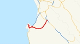
State Route 68 is a state highway that runs from Pacific Grove
to Salinas
in Monterey County
. It is about 20 miles (32.2 km) long.
and is eligible for the State Scenic Highway System
. However, only the part from SR 1 to the Salinas River
is designated by Caltrans as a scenic highway. The Monterey-Salinas Highway is a California Scenic Route because of its views of the chaparral
and springtime lupin
for 14 miles (22.5 km) between State Route 1 in Monterey to the Salinas River. State Route 68 is part of the Juan De Anza Trail
.
During the 1950s and 1960s, Caltrans had planned to upgrade Highway 68 to a freeway between Salinas and Highway 1
in Monterey, that was to start at US 101 south of the city and proceed west between Salinas and Spreckels
, serving as a bypass for Salinas. The freeway was to then follow the existing Highway 68 alignment into Monterey.
The freeway plan died as a result of environmental concerns along the route. The only portions of this freeway that were actually built were a 1 miles (1.6 km) section approaching the Highway 1 interchange in Monterey, and a 3 miles (4.8 km) segment starting in Spreckels and heading west, bypassing the unincorporated village of Toro Park. The segment around Spreckels opened in 1967 and included a pair of new bridges spanning the Salinas River
, which replaced an old truss bridge
built in 1889. At the western terminus of the Spreckels freeway segment, land acquired for the freeway can still be seen.
There continues to be discussions, but no definitive plans, to either bypass Route 68 or convert the existing road to 4-lanes by building a second roadway alongside the present 2-lane carriageway. Caltrans and Monterey County officials mention the most practical route for a bypass would be to the north of the existing Route 68, through Fort Ord
. A major upgrade of the Highway 68 corridor would cost on the order of $300 million. In the fall of 2007, Caltrans is scheduled to begin a $6 million project to implement safety upgrades at three major intersections along Highway 68.
Meanwhile, Caltrans and Monterey County are proceeding with a plan to divert Monterey-Salinas traffic away from Highway 68 by converting Davis Road and Reservation Road from two lanes to four between Highway 101 on the north side of Salinas and Highway 1 in Marina. These two roads pass through Fort Ord and the upgrades are using excess land set aside following the base's closure in 1994. The Davis Road/Reservation Road upgrade is a short-term fix, and most state and county officials realize that a permanent fix for Highway 68 will eventually be necessary.
The entire route is in Monterey County
.
{| class=wikitable
!Location
!Postmile
!Exit
!Destinations
!Notes
|-
|rowspan=2|Pacific Grove
|0.00
|
|Sinex Avenue – Asilomar State Beach
|
|-
|
|
|17-Mile Drive
|
|-
|rowspan=8|Monterey
|bgcolor=#ddffdd|L4.26
75.14Indicates that the postmile represents the distance along SR 1
rather than SR 68.
|bgcolor=#ddffdd|
|bgcolor=#ddffdd|
|bgcolor=#ddffdd|Interchange; west end of SR 1 overlap
|-
|colspan=4 align=center|West end of freeway on SR 1
|-bgcolor=#ffdddd
|R75.75
|399B
|Munras Avenue – Monterey
|No eastbound entrance
|-bgcolor=#ffdddd
|R76.00
|399C
|Soledad Drive, Munras Avenue
|Westbound exit and eastbound entrance
|-
|R77.38
|401A
|Aguajito Road – Monterey
|
|-bgcolor=#ddffdd
|R78.12
R3.95
|7B
|
|East end of SR 1 overlap
|-bgcolor=#ffdddd
|R3.99
|7B
|North Fremont Street – Seaside
|No eastbound entrance; signed as exit 401B eastbound
|-
|colspan=4 align=center|East end of freeway
|-
|Del Rey Oaks
|6.81
|
|
|
|-
|
|11.22
|
|
|
|-
|colspan=5 align=center|West end of freeway
|-
|
|15.83
|19
|Portola Drive
|
|-
|
|R17.19
|20
|
|
|-
|
|R18.08
|21
|Spreckels Boulevard
|
|-
|colspan=5 align=center|East end of freeway
|-
|rowspan=3|Salinas
|19.97
|
|.svg.png) Blanco Road to US 101
Blanco Road to US 101
|
|-
|22.02
|
|
|Interchange
|-
|22.02
|
|John Street
|Continuation beyond US 101
Pacific Grove, California
Pacific Grove is a coastal city in Monterey County, California, USA, with a population of 15,041 as of the 2010 census, down from 15,522 as of the 2000 census...
to Salinas
Salinas, California
Salinas is the county seat and the largest municipality of Monterey County, California. Salinas is located east-southeast of the mouth of the Salinas River, at an elevation of about 52 feet above sea level. The population was 150,441 at the 2010 census...
in Monterey County
Monterey County, California
Monterey County is a county located on the Pacific coast of the U.S. state of California, its northwestern section forming the southern half of Monterey Bay. The northern half of the bay is in Santa Cruz County. As of 2010, the population was 415,057. The county seat and largest city is Salinas...
. It is about 20 miles (32.2 km) long.
Route description
This route is part of the California Freeway and Expressway SystemCalifornia Freeway and Expressway System
The California Freeway and Expressway System is a system of existing or planned freeways and expressways in the U.S. state of California. It is defined by the Streets and Highways Code.-List of roads in the system:*State Route 1 *State Route 2...
and is eligible for the State Scenic Highway System
State Scenic Highway System (California)
The State Scenic Highway System is a list of highways, mainly state highways, that have been designated by the California Department of Transportation as scenic highways. The California State Legislature, primarily through Section 263 of the Streets and Highways Code, makes highways eligible for...
. However, only the part from SR 1 to the Salinas River
Salinas River (California)
The Salinas River is the largest river of the central coast of California, running and draining 4,160 square miles. It flows north-northwest and drains the Salinas Valley that slices through the Coast Range south from Monterey Bay...
is designated by Caltrans as a scenic highway. The Monterey-Salinas Highway is a California Scenic Route because of its views of the chaparral
Chaparral
Chaparral is a shrubland or heathland plant community found primarily in the U.S. state of California and in the northern portion of the Baja California peninsula, Mexico...
and springtime lupin
Lupin
Lupinus, commonly known as Lupins or lupines , is a genus in the legume family . The genus comprises about 280 species , with major centers of diversity in South and western North America , and the Andes and secondary centers in the Mediterranean region and Africa Lupinus, commonly known as Lupins...
for 14 miles (22.5 km) between State Route 1 in Monterey to the Salinas River. State Route 68 is part of the Juan De Anza Trail
Juan Bautista de Anza National Historic Trail
thumb|325px|MAP: [[Juan Bautista de Anza]] National Historic Trail routes in [[Arizona]] and [[California]].The Juan Bautista de Anza National Historic Trail is a National Park Service unit in the United States National Historic Trail and National Millennium Trail programs...
.
- Highway 68 is heavily traveled. The road has a design capacity of 16,000 vehicles per day. As of 2006, it carries about 26,000 vehicles per day. This figure is projected to increase as residential development in and around Salinas continues, and the Monterey Peninsula's tourism economy continues to expand.
- The Monterey-Salinas Highway is the main connector between Monterey and Salinas. http://www.montereycountyweekly.com/issues/Issue.02-10-2005/cover/Article.cover_story
- The Holman Highway is the main connector between Pacific Grove and Carmel.http://www.dot.ca.gov/hq/tsip/hseb/products/2006_Named_Freeways.pdf
- Traffic backs up on Highway 68 in the morning and afternoon since many people that work on the Monterey Peninsula live in Salinas, and vice versa.
- Highway 68 and the "68" road symbol have become iconic in Pacific Grove skating culture. This association developed after the opening of the skate shop "68 Skate".
Highway names
- Asilomar Boulevard - Start to Sunset Drive.
- Sunset Drive - For about 1/2 mile up a hill from the coast.
- Forest Avenue - Goes past multiple businesses, becomes Holman Hwy.
- W.R. Holman Highway - Pacific Grove to junction with State Route 1.
- Cabrillo Highway - Route 68 is synonymous with Route 1 for 2.5 miles (4 km).
- Monterey-Salinas Highway - Route 68 exits Route 1 and continues for 17 miles (27.4 km) to Salinas. Goes past Monterey Peninsula AirportMonterey Peninsula AirportMonterey Peninsula Airport is a regional airport located three miles southeast of the central business district of Monterey, a city in Monterey County, California, USA. It was created in 1936....
, Pasadera, Mazda Raceway Laguna SecaMazda Raceway Laguna SecaMazda Raceway Laguna Seca is a paved road racing track used for both auto racing and motorcycle racing, originally constructed in 1957 near both Salinas and Monterey, California, USA....
, Laureles Grade, Corral De Tierra, San Benancio, Toro Park and Spreckels. Freeway for first 1/2 mile and last 3 miles (4.8 km). - South Main Street - Monterey-Salinas becomes South Main at Salinas City Limits and continues to downtown.
- John Street - Route 68 makes a right off of Main and follows John St. to its terminus at U.S. Route 101.
History
Highway 68 is part of the DeAnza Trail, a route that linked all of California's mission settlements during the Spanish colonial period. With the advent of the automobile, Highway 68 was upgraded from a dirt wagon road to a 2-lane paved road in 1937.During the 1950s and 1960s, Caltrans had planned to upgrade Highway 68 to a freeway between Salinas and Highway 1
California State Route 1
State Route 1 , more often called Highway 1, is a state highway that runs along much of the Pacific coast of the U.S. state of California. It is famous for running along some of the most beautiful coastlines in the world, leading to its designation as an All-American Road.Highway 1 does not run...
in Monterey, that was to start at US 101 south of the city and proceed west between Salinas and Spreckels
Spreckels, California
Spreckels is a census-designated place located in the Salinas Valley of Monterey County, California, United States. Spreckels is located south of Salinas, at an elevation of 62 feet . The population was 673 at the 2010 census, up from 485 at the 2000 census.Spreckels is one of the best-preserved...
, serving as a bypass for Salinas. The freeway was to then follow the existing Highway 68 alignment into Monterey.
The freeway plan died as a result of environmental concerns along the route. The only portions of this freeway that were actually built were a 1 miles (1.6 km) section approaching the Highway 1 interchange in Monterey, and a 3 miles (4.8 km) segment starting in Spreckels and heading west, bypassing the unincorporated village of Toro Park. The segment around Spreckels opened in 1967 and included a pair of new bridges spanning the Salinas River
Salinas River (California)
The Salinas River is the largest river of the central coast of California, running and draining 4,160 square miles. It flows north-northwest and drains the Salinas Valley that slices through the Coast Range south from Monterey Bay...
, which replaced an old truss bridge
Truss bridge
A truss bridge is a bridge composed of connected elements which may be stressed from tension, compression, or sometimes both in response to dynamic loads. Truss bridges are one of the oldest types of modern bridges...
built in 1889. At the western terminus of the Spreckels freeway segment, land acquired for the freeway can still be seen.
There continues to be discussions, but no definitive plans, to either bypass Route 68 or convert the existing road to 4-lanes by building a second roadway alongside the present 2-lane carriageway. Caltrans and Monterey County officials mention the most practical route for a bypass would be to the north of the existing Route 68, through Fort Ord
Fort Ord
Fort Ord was a U.S. Army post on Monterey Bay in California. It was established in 1917 as a maneuver area and field artillery target range and was closed in September 1994. Fort Ord was one of the most attractive locations of any U.S. Army post, because of its proximity to the beach and California...
. A major upgrade of the Highway 68 corridor would cost on the order of $300 million. In the fall of 2007, Caltrans is scheduled to begin a $6 million project to implement safety upgrades at three major intersections along Highway 68.
Meanwhile, Caltrans and Monterey County are proceeding with a plan to divert Monterey-Salinas traffic away from Highway 68 by converting Davis Road and Reservation Road from two lanes to four between Highway 101 on the north side of Salinas and Highway 1 in Marina. These two roads pass through Fort Ord and the upgrades are using excess land set aside following the base's closure in 1994. The Davis Road/Reservation Road upgrade is a short-term fix, and most state and county officials realize that a permanent fix for Highway 68 will eventually be necessary.
Major intersections
- Note: Except where prefixed with a letter, postmiles were measured in 1964, based on the alignment as it existed at that time, and do not necessarily reflect current mileage.
The entire route is in Monterey County
Monterey County, California
Monterey County is a county located on the Pacific coast of the U.S. state of California, its northwestern section forming the southern half of Monterey Bay. The northern half of the bay is in Santa Cruz County. As of 2010, the population was 415,057. The county seat and largest city is Salinas...
.
{| class=wikitable
!Location
!Postmile
!Exit
Exit number
An exit number is a number assigned to a road junction, usually an exit from a freeway. It is usually marked on the same sign as the destinations of the exit, as well as a sign in the gore....
!Destinations
!Notes
|-
|rowspan=2|Pacific Grove
Pacific Grove, California
Pacific Grove is a coastal city in Monterey County, California, USA, with a population of 15,041 as of the 2010 census, down from 15,522 as of the 2000 census...
|0.00
|
|Sinex Avenue – Asilomar State Beach
Asilomar State Beach
Asilomar State Beach is a state park unit of California, USA, providing public access to rocky coast and dune habitat on the Monterey Peninsula. The property includes the Asilomar Conference Grounds, a conference center built in 1913 that is now a National Historic Landmark...
|
|-
|
|
|17-Mile Drive
17-Mile Drive
The 17 Mile Drive is a scenic road through Pacific Grove and Pebble Beach, California, much of which hugs the Pacific coastline and passes famous golf courses and mansions. It also serves as the main road through the gated community of Pebble Beach. Inside this community, non-residents have to pay...
|
|-
|rowspan=8|Monterey
Monterey, California
The City of Monterey in Monterey County is located on Monterey Bay along the Pacific coast in Central California. Monterey lies at an elevation of 26 feet above sea level. As of the 2010 census, the city population was 27,810. Monterey is of historical importance because it was the capital of...
|bgcolor=#ddffdd|L4.26
75.14Indicates that the postmile represents the distance along SR 1
California State Route 1
State Route 1 , more often called Highway 1, is a state highway that runs along much of the Pacific coast of the U.S. state of California. It is famous for running along some of the most beautiful coastlines in the world, leading to its designation as an All-American Road.Highway 1 does not run...
rather than SR 68.
|bgcolor=#ddffdd|
|bgcolor=#ddffdd|
|bgcolor=#ddffdd|Interchange; west end of SR 1 overlap
|-
|colspan=4 align=center|West end of freeway on SR 1
|-bgcolor=#ffdddd
|R75.75
|399B
|Munras Avenue – Monterey
Monterey, California
The City of Monterey in Monterey County is located on Monterey Bay along the Pacific coast in Central California. Monterey lies at an elevation of 26 feet above sea level. As of the 2010 census, the city population was 27,810. Monterey is of historical importance because it was the capital of...
|No eastbound entrance
|-bgcolor=#ffdddd
|R76.00
|399C
|Soledad Drive, Munras Avenue
|Westbound exit and eastbound entrance
|-
|R77.38
|401A
|Aguajito Road – Monterey
Monterey, California
The City of Monterey in Monterey County is located on Monterey Bay along the Pacific coast in Central California. Monterey lies at an elevation of 26 feet above sea level. As of the 2010 census, the city population was 27,810. Monterey is of historical importance because it was the capital of...
|
|-bgcolor=#ddffdd
|R78.12
R3.95
|7B
|
|East end of SR 1 overlap
|-bgcolor=#ffdddd
|R3.99
|7B
|North Fremont Street – Seaside
Seaside, California
Seaside is a city in Monterey County, California, United States, with a population of 33,025 as of the 2010 census. Seaside is located east-northeast of Monterey, at an elevation of 33 feet...
|No eastbound entrance; signed as exit 401B eastbound
|-
|colspan=4 align=center|East end of freeway
|-
|Del Rey Oaks
Del Rey Oaks, California
Del Rey Oaks is a city in Monterey County, California, United States. Del Rey Oaks is located just southeast of Seaside, at an elevation of 82 feet . The population was 1,650 at the 2000 census...
|6.81
|
|
|
|-
|
|11.22
|
|
|
|-
|colspan=5 align=center|West end of freeway
|-
|
|15.83
|19
|Portola Drive
|
|-
|
|R17.19
|20
|
|
|-
|
|R18.08
|21
|Spreckels Boulevard
|
|-
|colspan=5 align=center|East end of freeway
|-
|rowspan=3|Salinas
Salinas, California
Salinas is the county seat and the largest municipality of Monterey County, California. Salinas is located east-southeast of the mouth of the Salinas River, at an elevation of about 52 feet above sea level. The population was 150,441 at the 2010 census...
|19.97
|
|
|
|-
|22.02
|
|
|Interchange
|-
|22.02
|
|John Street
|Continuation beyond US 101