
Moss Landing, California
Encyclopedia
Moss Landing is a census-designated place
(CDP) in Monterey County
, California
, United States
. Moss Landing is located on the Pajaro Valley Consolidated Railroad 15 miles (24 km) north-northeast of Monterey
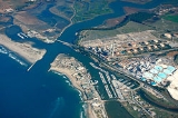
, at an elevation of 10 feet (3 m). As of the 2010 census, the CDP population was 204, down from 300 at the 2000 census. It is located on the shore of Monterey Bay
, at the mouth of Elkhorn Slough
, and at the head of the Monterey Canyon
. It is home to the Moss Landing Marine Laboratories
, a multi-campus research facility of the California State University
; and the Monterey Bay Aquarium Research Institute
, sister organization to the Monterey Bay Aquarium
.
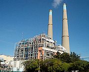
Moss Landing's most notable landmark is the Moss Landing Power Plant
. The natural gas plant, located at the intersection of State Route 1
and Dolan Road, produces 2,538 megawatts, is wholly owned by Dynegy
, and is visible from Santa Cruz, California
to the north and Monterey, California
to the south on clear days.
According to the United States Census Bureau
, the CDP has a total area of 0.6 square miles (1.6 km²), of which, 0.4 square miles (1 km²) of it is land and 0.2 square mile (0.517997622 km²) of it (34.06%) is water.
Prior to 1981, the community suffered from grave water contamination, severe septic tank failures, and public health problems. Sanitary sewers for the entire area were installed in 1982-84 due to federal grants secured by then Monterey County Supervisor Marc Del Piero.
was 338.3 people per square mile (130.6/km²). The racial makeup of Moss Landing was 149 (73.0%) White, 7 (3.4%) African American, 1 (0.5%) Native American, 2 (1.0%) Asian, 1 (0.5%) Pacific Islander, 30 (14.7%) from other races
, and 14 (6.9%) from two or more races. Hispanic or Latino of any race were 46 persons (22.5%).
The Census reported that 204 people (100% of the population) lived in households, 0 (0%) lived in non-institutionalized group quarters, and 0 (0%) were institutionalized.
There were 100 households, out of which 21 (21.0%) had children under the age of 18 living in them, 36 (36.0%) were opposite-sex married couples
living together, 11 (11.0%) had a female householder with no husband present, 4 (4.0%) had a male householder with no wife present. There were 8 (8.0%) unmarried opposite-sex partnerships
, and 0 (0%) same-sex married couples or partnerships. 41 households (41.0%) were made up of individuals and 11 (11.0%) had someone living alone who was 65 years of age or older. The average household size was 2.04. There were 51 families
(51.0% of all households); the average family size was 2.76.
The population was spread out with 32 people (15.7%) under the age of 18, 8 people (3.9%) aged 18 to 24, 54 people (26.5%) aged 25 to 44, 84 people (41.2%) aged 45 to 64, and 26 people (12.7%) who were 65 years of age or older. The median age was 46.5 years. For every 100 females there were 108.2 males. For every 100 females age 18 and over, there were 115.0 males.
There were 108 housing units at an average density of 179.1 per square mile (69.1/km²), of which 55 (55.0%) were owner-occupied, and 45 (45.0%) were occupied by renters. The homeowner vacancy rate was 0%; the rental vacancy rate was 8.2%. 118 people (57.8% of the population) lived in owner-occupied housing units and 86 people (42.2%) lived in rental housing units.
of 2000, there were 300 people, 125 households, and 68 families residing in the CDP. The population density
was 734.9 people per square mile (282.5/km²). There were 135 housing units at an average density of 330.7 per square mile (127.1/km²). The racial makeup of the CDP was 59.33% White, 3.00% African American, 0.67% Native American, 2.00% Asian, 21.67% from other races
, and 13.33% from two or more races. Hispanic or Latino of any race were 28.33% of the population.
There were 125 households out of which 27.2% had children under the age of 18 living with them, 39.2% were married couples
living together, 14.4% had a female householder with no husband present, and 45.6% were non-families. 31.2% of all households were made up of individuals and 8.8% had someone living alone who was 65 years of age or older. The average household size was 2.40 and the average family size was 3.09.
 In the CDP the population was spread out with 21.3% under the age of 18, 11.7% from 18 to 24, 34.3% from 25 to 44, 21.7% from 45 to 64, and 11.0% who were 65 years of age or older. The median age was 36 years. For every 100 females there were 117.4 males. For every 100 females age 18 and over, there were 118.5 males.
The median income for a household in the CDP was $66,442, and the median income for a family was $66,731. Males had a median income of $41,154 versus $36,691 for females. The per capita income
for the CDP was $28,005. About 13.0% of families and 18.8% of the population were below the poverty line, including 38.7% of those under the age of eighteen and none of those sixty five or over.
, Salinas River State Beach
, Zmudowski State Beach
, Moss Landing Wildlife Area
, and the Elkhorn Slough National Estuarine Research Reserve
.
Other events include the May opener for rock cod fishing, blessing the fleet May 1, open house at Moss Landing Marine Labs held in April or May, and Nautical Flea Market held in May.
Census-designated place
A census-designated place is a concentration of population identified by the United States Census Bureau for statistical purposes. CDPs are delineated for each decennial census as the statistical counterparts of incorporated places such as cities, towns and villages...
(CDP) in Monterey County
Monterey County, California
Monterey County is a county located on the Pacific coast of the U.S. state of California, its northwestern section forming the southern half of Monterey Bay. The northern half of the bay is in Santa Cruz County. As of 2010, the population was 415,057. The county seat and largest city is Salinas...
, California
California
California is a state located on the West Coast of the United States. It is by far the most populous U.S. state, and the third-largest by land area...
, United States
United States
The United States of America is a federal constitutional republic comprising fifty states and a federal district...
. Moss Landing is located on the Pajaro Valley Consolidated Railroad 15 miles (24 km) north-northeast of Monterey
Monterey, California
The City of Monterey in Monterey County is located on Monterey Bay along the Pacific coast in Central California. Monterey lies at an elevation of 26 feet above sea level. As of the 2010 census, the city population was 27,810. Monterey is of historical importance because it was the capital of...
, at an elevation of 10 feet (3 m). As of the 2010 census, the CDP population was 204, down from 300 at the 2000 census. It is located on the shore of Monterey Bay
Monterey Bay
Monterey Bay is a bay of the Pacific Ocean, along the central coast of California. The bay is south of San Francisco and San Jose, between the cities of Santa Cruz and Monterey....
, at the mouth of Elkhorn Slough
Elkhorn Slough
Elkhorn Slough is a tidal slough and estuary on Monterey Bay in Monterey County, California. The community of Moss Landing and the huge Moss Landing Power Plant are located at the mouth of the slough on the bay....
, and at the head of the Monterey Canyon
Monterey Canyon
Monterey Canyon, or Monterey Submarine Canyon, is a submarine canyon in Monterey Bay, California. It is the subject of ongoing study by the scientists at the Monterey Bay Aquarium Research Institute, the Moss Landing Marine Laboratories, and other oceanographic institutions.Monterey Canyon begins...
. It is home to the Moss Landing Marine Laboratories
Moss Landing Marine Laboratories
The Moss Landing Marine Laboratories is a multi-campus marine research consortium headquartered at Moss Landing, California.-Organization:...
, a multi-campus research facility of the California State University
California State University
The California State University is a public university system in the state of California. It is one of three public higher education systems in the state, the other two being the University of California system and the California Community College system. It is incorporated as The Trustees of the...
; and the Monterey Bay Aquarium Research Institute
Monterey Bay Aquarium Research Institute
The Monterey Bay Aquarium Research Institute is a not-for-profit oceanographic research center in Moss Landing, California affiliated with the Monterey Bay Aquarium. It was founded in 1987 by David Packard of Hewlett-Packard fame...
, sister organization to the Monterey Bay Aquarium
Monterey Bay Aquarium
The Monterey Bay Aquarium is located on the former site of a sardine cannery on Cannery Row of the Pacific Ocean shoreline in Monterey, California. It has an annual attendance of 1.8 million visitors. It holds thousands of plants and animals, representing 623 separate named species on display...
.
Moss Landing's most notable landmark is the Moss Landing Power Plant
Moss Landing Power Plant
The Moss Landing Power Plant is a natural gas powered electricity generation plant located in Moss Landing, California, at the midpoint of Monterey Bay. The plant's large stacks are landmarks, visible throughout the Monterey Bay Area.-History:...
. The natural gas plant, located at the intersection of State Route 1
California State Route 1
State Route 1 , more often called Highway 1, is a state highway that runs along much of the Pacific coast of the U.S. state of California. It is famous for running along some of the most beautiful coastlines in the world, leading to its designation as an All-American Road.Highway 1 does not run...
and Dolan Road, produces 2,538 megawatts, is wholly owned by Dynegy
Dynegy
Dynegy Inc. , based in Houston, Texas, United States, is a large owner and operator of power plants and a player in the natural gas liquids and coal business...
, and is visible from Santa Cruz, California
Santa Cruz, California
Santa Cruz is the county seat and largest city of Santa Cruz County, California in the US. As of the 2010 U.S. Census, Santa Cruz had a total population of 59,946...
to the north and Monterey, California
Monterey, California
The City of Monterey in Monterey County is located on Monterey Bay along the Pacific coast in Central California. Monterey lies at an elevation of 26 feet above sea level. As of the 2010 census, the city population was 27,810. Monterey is of historical importance because it was the capital of...
to the south on clear days.
Geography
Moss Landing is located at 36°48′16"N 121°47′13"W.According to the United States Census Bureau
United States Census Bureau
The United States Census Bureau is the government agency that is responsible for the United States Census. It also gathers other national demographic and economic data...
, the CDP has a total area of 0.6 square miles (1.6 km²), of which, 0.4 square miles (1 km²) of it is land and 0.2 square mile (0.517997622 km²) of it (34.06%) is water.
History
Moss Landing was originally called Moss. The Moss post office opened in 1895, and changed its name to Moss Landing in 1917. The name honors Charles Moss, who with a partner, built a wharf there. The port was a busy whaling port.Prior to 1981, the community suffered from grave water contamination, severe septic tank failures, and public health problems. Sanitary sewers for the entire area were installed in 1982-84 due to federal grants secured by then Monterey County Supervisor Marc Del Piero.
Demographics
2010
The 2010 United States Census reported that Moss Landing had a population of 204. The population densityPopulation density
Population density is a measurement of population per unit area or unit volume. It is frequently applied to living organisms, and particularly to humans...
was 338.3 people per square mile (130.6/km²). The racial makeup of Moss Landing was 149 (73.0%) White, 7 (3.4%) African American, 1 (0.5%) Native American, 2 (1.0%) Asian, 1 (0.5%) Pacific Islander, 30 (14.7%) from other races
Race (United States Census)
Race and ethnicity in the United States Census, as defined by the Federal Office of Management and Budget and the United States Census Bureau, are self-identification data items in which residents choose the race or races with which they most closely identify, and indicate whether or not they are...
, and 14 (6.9%) from two or more races. Hispanic or Latino of any race were 46 persons (22.5%).
The Census reported that 204 people (100% of the population) lived in households, 0 (0%) lived in non-institutionalized group quarters, and 0 (0%) were institutionalized.
There were 100 households, out of which 21 (21.0%) had children under the age of 18 living in them, 36 (36.0%) were opposite-sex married couples
Marriage
Marriage is a social union or legal contract between people that creates kinship. It is an institution in which interpersonal relationships, usually intimate and sexual, are acknowledged in a variety of ways, depending on the culture or subculture in which it is found...
living together, 11 (11.0%) had a female householder with no husband present, 4 (4.0%) had a male householder with no wife present. There were 8 (8.0%) unmarried opposite-sex partnerships
POSSLQ
POSSLQ is an abbreviation for "Persons of Opposite Sex Sharing Living Quarters," a term coined in the late 1970s by the United States Census Bureau as part of an effort to more accurately gauge the prevalence of cohabitation in American households....
, and 0 (0%) same-sex married couples or partnerships. 41 households (41.0%) were made up of individuals and 11 (11.0%) had someone living alone who was 65 years of age or older. The average household size was 2.04. There were 51 families
Family (U.S. Census)
A family or family household is defined by the United States Census Bureau for statistical purposes as "a householder and one or more other people related to the householder by birth, marriage, or adoption. They do not include same-sex married couples even if the marriage was performed in a state...
(51.0% of all households); the average family size was 2.76.
The population was spread out with 32 people (15.7%) under the age of 18, 8 people (3.9%) aged 18 to 24, 54 people (26.5%) aged 25 to 44, 84 people (41.2%) aged 45 to 64, and 26 people (12.7%) who were 65 years of age or older. The median age was 46.5 years. For every 100 females there were 108.2 males. For every 100 females age 18 and over, there were 115.0 males.
There were 108 housing units at an average density of 179.1 per square mile (69.1/km²), of which 55 (55.0%) were owner-occupied, and 45 (45.0%) were occupied by renters. The homeowner vacancy rate was 0%; the rental vacancy rate was 8.2%. 118 people (57.8% of the population) lived in owner-occupied housing units and 86 people (42.2%) lived in rental housing units.
2000
As of the censusCensus
A census is the procedure of systematically acquiring and recording information about the members of a given population. It is a regularly occurring and official count of a particular population. The term is used mostly in connection with national population and housing censuses; other common...
of 2000, there were 300 people, 125 households, and 68 families residing in the CDP. The population density
Population density
Population density is a measurement of population per unit area or unit volume. It is frequently applied to living organisms, and particularly to humans...
was 734.9 people per square mile (282.5/km²). There were 135 housing units at an average density of 330.7 per square mile (127.1/km²). The racial makeup of the CDP was 59.33% White, 3.00% African American, 0.67% Native American, 2.00% Asian, 21.67% from other races
Race (United States Census)
Race and ethnicity in the United States Census, as defined by the Federal Office of Management and Budget and the United States Census Bureau, are self-identification data items in which residents choose the race or races with which they most closely identify, and indicate whether or not they are...
, and 13.33% from two or more races. Hispanic or Latino of any race were 28.33% of the population.
There were 125 households out of which 27.2% had children under the age of 18 living with them, 39.2% were married couples
Marriage
Marriage is a social union or legal contract between people that creates kinship. It is an institution in which interpersonal relationships, usually intimate and sexual, are acknowledged in a variety of ways, depending on the culture or subculture in which it is found...
living together, 14.4% had a female householder with no husband present, and 45.6% were non-families. 31.2% of all households were made up of individuals and 8.8% had someone living alone who was 65 years of age or older. The average household size was 2.40 and the average family size was 3.09.
The median income for a household in the CDP was $66,442, and the median income for a family was $66,731. Males had a median income of $41,154 versus $36,691 for females. The per capita income
Per capita income
Per capita income or income per person is a measure of mean income within an economic aggregate, such as a country or city. It is calculated by taking a measure of all sources of income in the aggregate and dividing it by the total population...
for the CDP was $28,005. About 13.0% of families and 18.8% of the population were below the poverty line, including 38.7% of those under the age of eighteen and none of those sixty five or over.
Activities
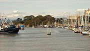
Moss Landing Harbor District berths over 600 boats: including 350 fishing boats, 200 pleasure craft, 30 research vessels, and a half dozen tour and charter boats. The harbor's commercial boats land dungeness crab, halibut, king salmon, albacore, rockfish, sablefish, anchovies, sardines, squid, black cod, red snapper, covina, prawns, mackrel, and others. Several maritime businesses support harbor users including a fuel dock. The harbor district also provides two public boat launches and a community park.Parks and nature reserves
Moss Landing provides access to state and federal protected lands, including surfing destination Moss Landing State BeachMoss Landing State Beach
Moss Landing State Beach is a beach in Monterey County, California.-Description:The beach is about north of the city of Monterey via Highway 1 at , about south of Watsonville. Among the most popular activities are offshore fishing, surfing, windsurfing and horseback riding. However, the strong...
, Salinas River State Beach
Salinas River State Beach
Salinas River State Beach is a beach located at the South end of Moss Landing, California. It can be accessed from the Potrero exit off of Highway 1, in Moss Landing. It is part of the 99 miles of Monterey County coastline...
, Zmudowski State Beach
Zmudowski State Beach
Zmudowski State Beach is a beach near Moss Landing in Monterey County, California, United States, operated by the California Department of Parks and Recreation. It is a popular fishing area, featuring perch, kingfish, sole, flounder, halibut, bocaccio , jacksmelt, lingcod, cabezon, salmon,...
, Moss Landing Wildlife Area
Moss Landing Wildlife Area
Moss Landing Wildlife Area is a California State wildlife preserve on the shore of Elkhorn Slough.-Description:The Moss Landing Wildlife Area protects of Monterey County, California, just north of the town of Moss Landing, California. It includes part of the largest unaltered salt marsh on the...
, and the Elkhorn Slough National Estuarine Research Reserve
Elkhorn Slough National Estuarine Research Reserve
The Elkhorn Slough National Estuarine Research Reserve is one of 28 National Estuarine Research Reserves established nationwide as field laboratories for scientific research and estuarine education. The Slough is located approximately south of San Francisco, California on the central shore of...
.
Events
The Moss Landing Antique Street Fair is held annually on the last Sunday in July and hosts hundreds of antique vendors. It brings over ten times the population of Moss Landing to the area.Other events include the May opener for rock cod fishing, blessing the fleet May 1, open house at Moss Landing Marine Labs held in April or May, and Nautical Flea Market held in May.