
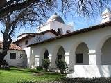
Fort Hunter Liggett
Overview
Hunter Liggett
Hunter Liggett was a lieutenant general of the United States Army. His forty-two years of service spanned the period from the Indian campaigns to trench warfare.-Biography:...
in 1941, is a United States Army
United States Army
The United States Army is the main branch of the United States Armed Forces responsible for land-based military operations. It is the largest and oldest established branch of the U.S. military, and is one of seven U.S. uniformed services...
fort in southern Monterey County, California
Monterey County, California
Monterey County is a county located on the Pacific coast of the U.S. state of California, its northwestern section forming the southern half of Monterey Bay. The northern half of the bay is in Santa Cruz County. As of 2010, the population was 415,057. The county seat and largest city is Salinas...
, about 250 miles (400 km) north of Los Angeles
Los Angeles, California
Los Angeles , with a population at the 2010 United States Census of 3,792,621, is the most populous city in California, USA and the second most populous in the United States, after New York City. It has an area of , and is located in Southern California...
and 150 miles (241.4 km) south of San Francisco
San Francisco, California
San Francisco , officially the City and County of San Francisco, is the financial, cultural, and transportation center of the San Francisco Bay Area, a region of 7.15 million people which includes San Jose and Oakland...
. The fort is primarily used as a training facility, where activities such as field maneuvers and live fire exercise
Live fire exercise
A live fire exercise or LFX is any exercise in which a realistic scenario for the use of specific equipment is simulated. In the popular lexicon this is applied primarily to tests of weapons or weapon systems that are associated with the various branches of a nation's armed forces, although the...
s are performed.
The Salinas Valley
Salinas Valley
The Salinas Valley lies south of San Francisco, California.The word "salina" is spanish for salt marsh, salt lake or salt pan.-Geography:The Salinas Valley runs approximately south-east from Salinas towards King City. The valley lends its name to the geologic province in which it's located, the...
is the fort's northern border, the Santa Lucia Mountains
Santa Lucia Mountains
The Santa Lucia Mountains or Santa Lucia Range is a mountain range in coastal California, running from Monterey southeast for 105 miles to San Luis Obispo. The highest summit is Junipero Serra Peak, in Monterey County...
bound it on the east, Los Padres National Forest
Los Padres National Forest
Los Padres National Forest is a forest located in southern and central California, which includes most of the mountainous land along the California coast from Ventura to Monterey, extending inland...
on the west and the Monterey and San Luis Obispo County
San Luis Obispo County, California
San Luis Obispo County is a county located along the Pacific Ocean in the Central Coast of the U.S. state of California, between Los Angeles and the San Francisco Bay Area. As of the 2010 census its population was 269,637, up from 246,681 at the 2000 census...
line on the south.