
Late-March 2007 Tornado Outbreak
Encyclopedia
The Late-March 2007 Tornado Outbreak was a tornado outbreak
that took place across the central United States
. It developed in the High Plains
from South Dakota
to central Texas
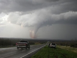
on March 28, 2007, which produced most of the tornadoes. Several more tornadoes were reported the next three days before the system weakened on March 31. It affected western Nebraska
, western Kansas
, extreme eastern Colorado
, and much of Oklahoma
, and Texas
. It was the second major outbreak of 2007, four weeks after an outbreak farther east
. The outbreak produced at least 81 tornado
es, and at least five deaths and extensive damage was reported. In addition to the tornadoes, widespread hail
as large as softball
s and destructive straight-line winds as strong as 90 mph (145 km/h) were reported.
The activity level was very uncertain for March 29, as it was conditional on the dry line
refiring. Despite the squall line
remaining intact, several more tornadoes developed. Several more tornadoes developed on March 30 and 31 before the system weakened.
region on May 28. The system was located over the Great Basin
and moved eastward into the central Rocky Mountains
during this time frame. Ahead of the system, a dry line
became organized from a low-pressure area over extreme northeastern Colorado
and Nebraska
panhandle
southwards into western Texas
. Increasing south to southeasterly winds close and above the surface allowed for a progressively humid air mass
to spread across the western portion of the Great Plains during the afternoon. Unseasonably warm surface temperatures and increased lift ahead of the approaching system supported rapid thunderstorm
formation. This altogether allowed for the potential for large hail, damaging winds and tornadoes.
That afternoon, the first signs of severe weather developed, and tornado watch
es were issued from South Dakota
south to Texas
. The advancing dry line
and the cold front
moving eastward combined to produce explosive supercell
development late in the afternoon. Early that evening, supercells with severe thunderstorm
s and tornadoes were occurring along a nearly continuous line from near Lubbock, Texas
to Rapid City, South Dakota
. Before the supercells reformed into a squall line
late that evening, at least 63 tornadoes were reported, many of them were very large and potentially destructive. Fortunately, the area is sparsely populated, preventing widespread death and destruction. Still, at least 4 people were killed.
A tornado was reported by the public south of Holly, Colorado at 7:57 p.m. MDT which caused one death and 11 injuries, of which 8 were hospitalized. A 76 year-old woman later died one month after the event. 60 homes were damaged and 5 were destroyed. Another tornado near Elmwood, Oklahoma killed 2, making it the first fatalities in Oklahoma caused by a tornado in well over 5 years.
On March 29, the squall line that moved eastward prevented a major outbreak during the daytime hours. Only a slight risk of severe storms was issued. Nonetheless, several tornadoes were reported, with two striking in the Oklahoma City
metropolitan area with next to no advance warning before they struck. Significant damage was reported there with at least two people hospitalized when their RV
was hit and four others injured during a tornado ten minutes later.
Another moderate risk was issued for March 30, this time in south-central Texas
into the Mexican
state of Coahuila
, which was later extended into north Texas and into south-central Oklahoma
. At around 2254 UTC, one of the two tornado watches in effect during the day in Texas was lifted, although a watch remained in central and north-eastern Texas. Late in the day, the Oklahoma tornado watch was extended into eastern Kansas
.
For March 31, a moderate risk was issued for central Texas with the storm line continuing through the state, along with Oklahoma and Kansas in a north-eastern direction. This outlook was later changed to a slight risk as the system continued on with a tornado watch in effect in south-eastern Texas and a thunderstorm watch in Louisiana
. The tornado watch was discontinued around 1504 UTC, although tornado warnings were issued in south-eastern Arkansas
. Later in the day, the system reached the north-central United States, which caused warnings to be issued in Wisconsin
, Illinois
and Iowa
. As the system continued to move in its north-eastern direction in the early evening, a watch was extended into the north-western portion of Indiana
. The system weakened that evening and no tornadoes occurred afterward. However, NWS officials later confirmed a microburst
in Carol Stream
and Glendale Heights
in DuPage County
just west of Chicago
just before 10:00 PM CDT. Extensive roof and window damage was reported to buildings, including an apartment complex and a church. The damage path was about 0.5 miles (0.8 km) long and 250 yards wide.
Tornado outbreak
While there is no single agreed upon definition, generally at least 6-10 tornadoes produced by the same synoptic scale weather system is considered a tornado outbreak. The tornadoes usually occur within the same day, or continue into the early morning hours of the succeeding day, and within the...
that took place across the central United States
Central United States
The Central United States is sometimes conceived as between the Eastern United States and Western United States as part of a three-region model, roughly coincident with the Midwestern United States plus the western and central portions of the Southern United States; the term is also sometimes used...
. It developed in the High Plains
High Plains
High Plains refers to one of two distinct land regions:*High Plains , land region of the western Great Plains*High Plains , land region adjacent to the Great Dividing Range...
from South Dakota
South Dakota
South Dakota is a state located in the Midwestern region of the United States. It is named after the Lakota and Dakota Sioux American Indian tribes. Once a part of Dakota Territory, South Dakota became a state on November 2, 1889. The state has an area of and an estimated population of just over...
to central Texas
Texas
Texas is the second largest U.S. state by both area and population, and the largest state by area in the contiguous United States.The name, based on the Caddo word "Tejas" meaning "friends" or "allies", was applied by the Spanish to the Caddo themselves and to the region of their settlement in...
on March 28, 2007, which produced most of the tornadoes. Several more tornadoes were reported the next three days before the system weakened on March 31. It affected western Nebraska
Nebraska
Nebraska is a state on the Great Plains of the Midwestern United States. The state's capital is Lincoln and its largest city is Omaha, on the Missouri River....
, western Kansas
Kansas
Kansas is a US state located in the Midwestern United States. It is named after the Kansas River which flows through it, which in turn was named after the Kansa Native American tribe, which inhabited the area. The tribe's name is often said to mean "people of the wind" or "people of the south...
, extreme eastern Colorado
Colorado
Colorado is a U.S. state that encompasses much of the Rocky Mountains as well as the northeastern portion of the Colorado Plateau and the western edge of the Great Plains...
, and much of Oklahoma
Oklahoma
Oklahoma is a state located in the South Central region of the United States of America. With an estimated 3,751,351 residents as of the 2010 census and a land area of 68,667 square miles , Oklahoma is the 28th most populous and 20th-largest state...
, and Texas
Texas
Texas is the second largest U.S. state by both area and population, and the largest state by area in the contiguous United States.The name, based on the Caddo word "Tejas" meaning "friends" or "allies", was applied by the Spanish to the Caddo themselves and to the region of their settlement in...
. It was the second major outbreak of 2007, four weeks after an outbreak farther east
February-March 2007 Tornado Outbreak
The February–March 2007 Tornado Outbreak was a tornado outbreak across the southern United States that began in Kansas on February 28, 2007. The severe weather spread eastward on March 1 and left a deadly mark across the southern US, particularly in Alabama and Georgia. Twenty deaths were...
. The outbreak produced at least 81 tornado
Tornado
A tornado is a violent, dangerous, rotating column of air that is in contact with both the surface of the earth and a cumulonimbus cloud or, in rare cases, the base of a cumulus cloud. They are often referred to as a twister or a cyclone, although the word cyclone is used in meteorology in a wider...
es, and at least five deaths and extensive damage was reported. In addition to the tornadoes, widespread hail
Hail
Hail is a form of solid precipitation. It consists of balls or irregular lumps of ice, each of which is referred to as a hail stone. Hail stones on Earth consist mostly of water ice and measure between and in diameter, with the larger stones coming from severe thunderstorms...
as large as softball
Softball
Softball is a bat-and-ball sport played between two teams of 10 to 14 players. It is a direct descendant of baseball although there are some key differences: softballs are larger than baseballs, and the pitches are thrown underhand rather than overhand...
s and destructive straight-line winds as strong as 90 mph (145 km/h) were reported.
The activity level was very uncertain for March 29, as it was conditional on the dry line
Dry line
A dry line separates moist air from the Gulf of Mexico and dry desert air from the south-western states . The dry line is an important factor in severe weather frequency in the Great Plains of North America...
refiring. Despite the squall line
Squall line
A squall line is a line of severe thunderstorms that can form along or ahead of a cold front. In the early 20th century, the term was used as a synonym for cold front. It contains heavy precipitation, hail, frequent lightning, strong straight-line winds, and possibly tornadoes and waterspouts....
remaining intact, several more tornadoes developed. Several more tornadoes developed on March 30 and 31 before the system weakened.
Meteorological synopsis
A powerful mid and upper level system brought terrifically strong wind fields aloft over the southern and central Great PlainsGreat Plains
The Great Plains are a broad expanse of flat land, much of it covered in prairie, steppe and grassland, which lies west of the Mississippi River and east of the Rocky Mountains in the United States and Canada. This area covers parts of the U.S...
region on May 28. The system was located over the Great Basin
Great Basin
The Great Basin is the largest area of contiguous endorheic watersheds in North America and is noted for its arid conditions and Basin and Range topography that varies from the North American low point at Badwater Basin to the highest point of the contiguous United States, less than away at the...
and moved eastward into the central Rocky Mountains
Rocky Mountains
The Rocky Mountains are a major mountain range in western North America. The Rocky Mountains stretch more than from the northernmost part of British Columbia, in western Canada, to New Mexico, in the southwestern United States...
during this time frame. Ahead of the system, a dry line
Dry line
A dry line separates moist air from the Gulf of Mexico and dry desert air from the south-western states . The dry line is an important factor in severe weather frequency in the Great Plains of North America...
became organized from a low-pressure area over extreme northeastern Colorado
Colorado
Colorado is a U.S. state that encompasses much of the Rocky Mountains as well as the northeastern portion of the Colorado Plateau and the western edge of the Great Plains...
and Nebraska
Nebraska
Nebraska is a state on the Great Plains of the Midwestern United States. The state's capital is Lincoln and its largest city is Omaha, on the Missouri River....
panhandle
Nebraska Panhandle
The Nebraska Panhandle is an area in the west of the state of Nebraska. A panhandle is an area extending from the rest of a political unit; the Nebraska panhandle is two-thirds as broad as the rest of the state. It is approximately 100 miles east to west and 125 miles north to south...
southwards into western Texas
Texas
Texas is the second largest U.S. state by both area and population, and the largest state by area in the contiguous United States.The name, based on the Caddo word "Tejas" meaning "friends" or "allies", was applied by the Spanish to the Caddo themselves and to the region of their settlement in...
. Increasing south to southeasterly winds close and above the surface allowed for a progressively humid air mass
Air mass
In meteorology, an air mass is a volume of air defined by its temperature and water vapor content. Air masses cover many hundreds or thousands of square miles, and adopt the characteristics of the surface below them. They are classified according to latitude and their continental or maritime...
to spread across the western portion of the Great Plains during the afternoon. Unseasonably warm surface temperatures and increased lift ahead of the approaching system supported rapid thunderstorm
Thunderstorm
A thunderstorm, also known as an electrical storm, a lightning storm, thundershower or simply a storm is a form of weather characterized by the presence of lightning and its acoustic effect on the Earth's atmosphere known as thunder. The meteorologically assigned cloud type associated with the...
formation. This altogether allowed for the potential for large hail, damaging winds and tornadoes.
That afternoon, the first signs of severe weather developed, and tornado watch
Tornado watch
A tornado watch is issued when conditions are right for a tornado to form. Since any thunderstorm capable of producing a tornado is defined as severe, a tornado watch is also automatically a severe thunderstorm watch...
es were issued from South Dakota
South Dakota
South Dakota is a state located in the Midwestern region of the United States. It is named after the Lakota and Dakota Sioux American Indian tribes. Once a part of Dakota Territory, South Dakota became a state on November 2, 1889. The state has an area of and an estimated population of just over...
south to Texas
Texas
Texas is the second largest U.S. state by both area and population, and the largest state by area in the contiguous United States.The name, based on the Caddo word "Tejas" meaning "friends" or "allies", was applied by the Spanish to the Caddo themselves and to the region of their settlement in...
. The advancing dry line
Dry line
A dry line separates moist air from the Gulf of Mexico and dry desert air from the south-western states . The dry line is an important factor in severe weather frequency in the Great Plains of North America...
and the cold front
Cold front
A cold front is defined as the leading edge of a cooler mass of air, replacing a warmer mass of air.-Development of cold front:The cooler and denser air wedges under the less-dense warmer air, lifting it...
moving eastward combined to produce explosive supercell
Supercell
A supercell is a thunderstorm that is characterized by the presence of a mesocyclone: a deep, continuously-rotating updraft. For this reason, these storms are sometimes referred to as rotating thunderstorms...
development late in the afternoon. Early that evening, supercells with severe thunderstorm
Thunderstorm
A thunderstorm, also known as an electrical storm, a lightning storm, thundershower or simply a storm is a form of weather characterized by the presence of lightning and its acoustic effect on the Earth's atmosphere known as thunder. The meteorologically assigned cloud type associated with the...
s and tornadoes were occurring along a nearly continuous line from near Lubbock, Texas
Lubbock, Texas
Lubbock is a city in and the county seat of Lubbock County, Texas, United States. The city is located in the northwestern part of the state, a region known historically as the Llano Estacado, and the home of Texas Tech University and Lubbock Christian University...
to Rapid City, South Dakota
Rapid City, South Dakota
Rapid City is the second-largest city in the U.S. state of South Dakota, and the county seat of Pennington County. Named after Rapid Creek on which the city is established, it is set against the eastern slope of the Black Hills mountain range. The population was 67,956 as of the 2010 Census. Rapid...
. Before the supercells reformed into a squall line
Squall line
A squall line is a line of severe thunderstorms that can form along or ahead of a cold front. In the early 20th century, the term was used as a synonym for cold front. It contains heavy precipitation, hail, frequent lightning, strong straight-line winds, and possibly tornadoes and waterspouts....
late that evening, at least 63 tornadoes were reported, many of them were very large and potentially destructive. Fortunately, the area is sparsely populated, preventing widespread death and destruction. Still, at least 4 people were killed.
A tornado was reported by the public south of Holly, Colorado at 7:57 p.m. MDT which caused one death and 11 injuries, of which 8 were hospitalized. A 76 year-old woman later died one month after the event. 60 homes were damaged and 5 were destroyed. Another tornado near Elmwood, Oklahoma killed 2, making it the first fatalities in Oklahoma caused by a tornado in well over 5 years.
On March 29, the squall line that moved eastward prevented a major outbreak during the daytime hours. Only a slight risk of severe storms was issued. Nonetheless, several tornadoes were reported, with two striking in the Oklahoma City
Oklahoma City, Oklahoma
Oklahoma City is the capital and the largest city in the state of Oklahoma. The county seat of Oklahoma County, the city ranks 31st among United States cities in population. The city's population, from the 2010 census, was 579,999, with a metro-area population of 1,252,987 . In 2010, the Oklahoma...
metropolitan area with next to no advance warning before they struck. Significant damage was reported there with at least two people hospitalized when their RV
Recreational vehicle
Recreational vehicle or RV is, in North America, the usual term for a Motor vehicle or trailer equipped with living space and amenities found in a home.-Features:...
was hit and four others injured during a tornado ten minutes later.
Another moderate risk was issued for March 30, this time in south-central Texas
Texas
Texas is the second largest U.S. state by both area and population, and the largest state by area in the contiguous United States.The name, based on the Caddo word "Tejas" meaning "friends" or "allies", was applied by the Spanish to the Caddo themselves and to the region of their settlement in...
into the Mexican
Mexico
The United Mexican States , commonly known as Mexico , is a federal constitutional republic in North America. It is bordered on the north by the United States; on the south and west by the Pacific Ocean; on the southeast by Guatemala, Belize, and the Caribbean Sea; and on the east by the Gulf of...
state of Coahuila
Coahuila
Coahuila, formally Coahuila de Zaragoza , officially Estado Libre y Soberano de Coahuila de Zaragoza is one of the 31 states which, with the Federal District, comprise the 32 Federal Entities of Mexico...
, which was later extended into north Texas and into south-central Oklahoma
Oklahoma
Oklahoma is a state located in the South Central region of the United States of America. With an estimated 3,751,351 residents as of the 2010 census and a land area of 68,667 square miles , Oklahoma is the 28th most populous and 20th-largest state...
. At around 2254 UTC, one of the two tornado watches in effect during the day in Texas was lifted, although a watch remained in central and north-eastern Texas. Late in the day, the Oklahoma tornado watch was extended into eastern Kansas
Kansas
Kansas is a US state located in the Midwestern United States. It is named after the Kansas River which flows through it, which in turn was named after the Kansa Native American tribe, which inhabited the area. The tribe's name is often said to mean "people of the wind" or "people of the south...
.
For March 31, a moderate risk was issued for central Texas with the storm line continuing through the state, along with Oklahoma and Kansas in a north-eastern direction. This outlook was later changed to a slight risk as the system continued on with a tornado watch in effect in south-eastern Texas and a thunderstorm watch in Louisiana
Louisiana
Louisiana is a state located in the southern region of the United States of America. Its capital is Baton Rouge and largest city is New Orleans. Louisiana is the only state in the U.S. with political subdivisions termed parishes, which are local governments equivalent to counties...
. The tornado watch was discontinued around 1504 UTC, although tornado warnings were issued in south-eastern Arkansas
Arkansas
Arkansas is a state located in the southern region of the United States. Its name is an Algonquian name of the Quapaw Indians. Arkansas shares borders with six states , and its eastern border is largely defined by the Mississippi River...
. Later in the day, the system reached the north-central United States, which caused warnings to be issued in Wisconsin
Wisconsin
Wisconsin is a U.S. state located in the north-central United States and is part of the Midwest. It is bordered by Minnesota to the west, Iowa to the southwest, Illinois to the south, Lake Michigan to the east, Michigan to the northeast, and Lake Superior to the north. Wisconsin's capital is...
, Illinois
Illinois
Illinois is the fifth-most populous state of the United States of America, and is often noted for being a microcosm of the entire country. With Chicago in the northeast, small industrial cities and great agricultural productivity in central and northern Illinois, and natural resources like coal,...
and Iowa
Iowa
Iowa is a state located in the Midwestern United States, an area often referred to as the "American Heartland". It derives its name from the Ioway people, one of the many American Indian tribes that occupied the state at the time of European exploration. Iowa was a part of the French colony of New...
. As the system continued to move in its north-eastern direction in the early evening, a watch was extended into the north-western portion of Indiana
Indiana
Indiana is a US state, admitted to the United States as the 19th on December 11, 1816. It is located in the Midwestern United States and Great Lakes Region. With 6,483,802 residents, the state is ranked 15th in population and 16th in population density. Indiana is ranked 38th in land area and is...
. The system weakened that evening and no tornadoes occurred afterward. However, NWS officials later confirmed a microburst
Microburst
A microburst is a very localized column of sinking air, producing damaging divergent and straight-line winds at the surface that are similar to, but distinguishable from, tornadoes, which generally have convergent damage. There are two types of microbursts: wet microbursts and dry microbursts...
in Carol Stream
Carol Stream, Illinois
Carol Stream is a village in DuPage County, Illinois, United States. Incorporated on January 5, 1959, and named after the developer's daughter, Carol Stream had a population of 40,438 as of the 2000 U.S. census.- History :...
and Glendale Heights
Glendale Heights, Illinois
Glendale Heights is a village in DuPage County, Illinois, United States. The population was 31,765 at the 2000 census.-History:Glendale Heights was a small farming area served by the Glen Ellyn post office up until the 1950s, with a population of just 104 in 1959. Midland Enterprises ran by Charles...
in DuPage County
DuPage County, Illinois
As of the 2010 Census, the population of the county was 916,924, White Americans made up 77.9% of Dupage County's population; non-Hispanic whites represented 70.5% of the population. Black Americans made up 4.6% of the population. Native Americans made up 0.3% of Dupage County's population...
just west of Chicago
Chicago
Chicago is the largest city in the US state of Illinois. With nearly 2.7 million residents, it is the most populous city in the Midwestern United States and the third most populous in the US, after New York City and Los Angeles...
just before 10:00 PM CDT. Extensive roof and window damage was reported to buildings, including an apartment complex and a church. The damage path was about 0.5 miles (0.8 km) long and 250 yards wide.
Confirmed Tornadoes
March 28 event
| List of confirmed tornadoes - Wednesday, March 28, 2007 | ||||||
|---|---|---|---|---|---|---|
Enhanced Fujita Scale The Enhanced Fujita Scale rates the strength of tornadoes in the United States based on the damage they cause.Implemented in place of the Fujita scale introduced in 1971 by Ted Fujita, it began operational use on February 1, 2007. The scale has the same basic design as the original Fujita scale:... |
|
|
|
|
|
|
| Illinois Illinois Illinois is the fifth-most populous state of the United States of America, and is often noted for being a microcosm of the entire country. With Chicago in the northeast, small industrial cities and great agricultural productivity in central and northern Illinois, and natural resources like coal,... |
||||||
| EF0 | N of Atlanta Atlanta, Illinois Atlanta is a city in Logan County, Illinois, United States. The population was 1,649 at the 2000 census, and 1,635 at a 2009 estimate.-Geography:Atlanta is located at .... |
Logan Logan County, Illinois Logan County is a county located in the U.S. state of Illinois. According to the 2010 census, it has a population of 30,305, which is a decrease of 2.8% from 31,183 in 2000... |
40.28°N 89.23°W | 2005 | 0.1 mile (0.160934 km) | Brief touchdown, no damage reported. |
| EF0 | SW of McLean McLean, Illinois McLean is a village in McLean County, Illinois, United States. The population was 830 at the 2010 census. It is part of the Bloomington–Normal Metropolitan Statistical Area.-Geography:McLean is located at .... |
McLean McLean County, Illinois McLean County is a county in the U.S. state of Illinois. McLean County is included in the Bloomington–Normal, Illinois Metropolitan Statistical Area. According to the 2010 census, it has a population of 169,572, which is an increase of 12.7% from 150,433 in 2000. Its county seat is... |
40.3°N 89.2°W | 2019 | 0.1 mile (0.160934 km) | Brief touchdown, no damage reported. |
| Texas Texas Texas is the second largest U.S. state by both area and population, and the largest state by area in the contiguous United States.The name, based on the Caddo word "Tejas" meaning "friends" or "allies", was applied by the Spanish to the Caddo themselves and to the region of their settlement in... |
||||||
| EF0 | Silverton Silverton, Texas Silverton is a city in Briscoe County, Texas, United States. The population was 771 at the 2000 census. It is the county seat of Briscoe County.-Geography:Silverton is located at .... area (1st tornado) |
Swisher Swisher County, Texas Swisher County is a county located in the U.S. state of Texas. In 2000, its population was 8,378. Its seat is Tulia. The county is named for James G. Swisher, a soldier of the Texas Revolution and signer of the Texas Declaration of Independence... , Briscoe |
34.28°N 101.5°W | 2220 | 2.5 miles (4 km) | Brief touchdown, no damage reported. |
| EF0 | SW of Silverton Silverton, Texas Silverton is a city in Briscoe County, Texas, United States. The population was 771 at the 2000 census. It is the county seat of Briscoe County.-Geography:Silverton is located at .... (2nd tornado) |
Briscoe | 34.37°N 101.42°W | 2228 | 2 miles (3.2 km) | Brief touchdown, no damage reported. |
| EF1 | S of Silverton Silverton, Texas Silverton is a city in Briscoe County, Texas, United States. The population was 771 at the 2000 census. It is the county seat of Briscoe County.-Geography:Silverton is located at .... (3rd tornado) |
Briscoe | 34.45°N 101.36°W | 2248 | 6.8 miles (10.9 km) | Caused $40,000 in damages. |
| EF0 | SE of South Plains South Plains, Texas South Plains is an unincorporated community in northern Floyd County, Texas, United States. It lies along State Highway 207 north of the city of Floydada, the county seat of Floyd County. Its elevation is 3,215 feet... |
Floyd | 34.25°N 101.32°W | 2303 | 0.5 mile (0.80467 km) | Brief touchdown, caused $10,000. |
| EF0 | NE of Silverton Silverton, Texas Silverton is a city in Briscoe County, Texas, United States. The population was 771 at the 2000 census. It is the county seat of Briscoe County.-Geography:Silverton is located at .... (4th tornado) |
Briscoe | 34.54°N 101.22°W | 2303 | 4.8 miles (7.7 km) | Brief touchdown, no damage reported. |
| EF0 | NE of Silverton Silverton, Texas Silverton is a city in Briscoe County, Texas, United States. The population was 771 at the 2000 census. It is the county seat of Briscoe County.-Geography:Silverton is located at .... (5th tornado) |
Briscoe | 34.67°N 101.2°W | 2310 | 1.8 miles (2.9 km) | Brief touchdown, no damage reported. |
| EF2 | N of Quitaque Quitaque, Texas Quitaque is a city in Briscoe County, Texas, United States. The population was 432 at the 2000 census.The Texas high school football and college coach Gene Mayfield was born in Quitaque in 1928.-Geography:Quitaque is located at .... |
Briscoe, Hall, Donley Donley County, Texas Donley County is a county located in the U.S. state of Texas. In 2000, its population was 3,828. It is named for Stockton P. Donley, a frontier lawyer. Its county seat is Clarendon.... |
34.5°N 101.5°W | 2335 | 23.8 miles (38.3 km) | Long track quarter-mile-wide tornado, caused $180,000 in damages. |
| EF0 | SW of Clarendon Clarendon, Texas Clarendon is a city in Donley County, Texas, United States. The population was 1,974 at the 2000 census. The county seat of Donley County, Clarendon is located on United States Highway 287 in the Texas Panhandle some sixty miles east of Amarillo. It was established in 1878 by Methodist clergyman L.H... |
Donley Donley County, Texas Donley County is a county located in the U.S. state of Texas. In 2000, its population was 3,828. It is named for Stockton P. Donley, a frontier lawyer. Its county seat is Clarendon.... |
34.8°N 101.06°W | 2340 | 1 miles (1.6 km) | Brief touchdown, no damage reported. |
| EF0 | SSW of Clarendon Clarendon, Texas Clarendon is a city in Donley County, Texas, United States. The population was 1,974 at the 2000 census. The county seat of Donley County, Clarendon is located on United States Highway 287 in the Texas Panhandle some sixty miles east of Amarillo. It was established in 1878 by Methodist clergyman L.H... |
Donley Donley County, Texas Donley County is a county located in the U.S. state of Texas. In 2000, its population was 3,828. It is named for Stockton P. Donley, a frontier lawyer. Its county seat is Clarendon.... |
34.77°N 100.98°W | 0005 | 1 miles (1.6 km) | Brief touchdown, no damage reported. |
| EF2 | Brooker area | Lipscomb, Beaver (OK) Beaver County, Oklahoma Beaver County is a county located in the U.S. state of Oklahoma. As of the 2010 census, the population was 5,636. The county seat is Beaver.... |
36.45°N 100.44°W | 0016 | 22 miles (35.4 km) | 2 deaths Widespread debris and damage reported. Long track tornado, caused $100,000 in damages. |
| EF3 | Jericho area (1st tornado) | Donley Donley County, Texas Donley County is a county located in the U.S. state of Texas. In 2000, its population was 3,828. It is named for Stockton P. Donley, a frontier lawyer. Its county seat is Clarendon.... , Gray |
35.13°N 100.94°W | 0039 | 6.4 miles (10.3 km) | 4 Injuries Several tractor-trailers flipped on Interstate 40 Interstate 40 Interstate 40 is the third-longest major east–west Interstate Highway in the United States, after I-90 and I-80. Its western end is at Interstate 15 in Barstow, California; its eastern end is at a concurrency of U.S. Route 117 and North Carolina Highway 132 in Wilmington, North Carolina... several houses were damaged and barns were destroyed as well. Originally rated as an EF2 but was later upgraded to an EF3. Caused $280,000 in damages. |
| EF2 | SW of Amarillo Amarillo, Texas Amarillo is the 14th-largest city, by population, in the state of Texas, the largest in the Texas Panhandle, and the seat of Potter County. A portion of the city extends into Randall County. The population was 190,695 at the 2010 census... |
Donley Donley County, Texas Donley County is a county located in the U.S. state of Texas. In 2000, its population was 3,828. It is named for Stockton P. Donley, a frontier lawyer. Its county seat is Clarendon.... |
34.93°N 100.74°W | 0046 | 4.2 miles (6.8 km) | Heavy tree damage, and one barn was destroyed. Several other outbuildings were damaged, caused $60,000 in damages. |
| EF0 | N of Hedley Hedley, Texas Hedley is a city in Donley County, Texas, United States. The population was 379 at the 2000 census.-Geography:Hedley is located at .According to the United States Census Bureau, the city has a total area of , all of it land.... |
Donley Donley County, Texas Donley County is a county located in the U.S. state of Texas. In 2000, its population was 3,828. It is named for Stockton P. Donley, a frontier lawyer. Its county seat is Clarendon.... |
35.03°N 100.67°W | 0102 | 0.3 mile (0.482802 km) | Brief touchdown, no damage reported. |
| EF2 | McLean McLean, Texas McLean is a town in Gray County, Texas, United States. It is part of the Pampa, Texas Micropolitan Statistical Area. The population was 830 at the 2000 census.-Geography:McLean is located at .... area (1st tornado) |
Donley Donley County, Texas Donley County is a county located in the U.S. state of Texas. In 2000, its population was 3,828. It is named for Stockton P. Donley, a frontier lawyer. Its county seat is Clarendon.... |
35.12°N 100.78°W | 0113 | 4.5 miles (7.2 km) | Heavy damage to several houses. Major tree and power line damage. Caused $170,000 in damages. |
| EF0 | SE of Jericho (2nd tornado) | Donley Donley County, Texas Donley County is a county located in the U.S. state of Texas. In 2000, its population was 3,828. It is named for Stockton P. Donley, a frontier lawyer. Its county seat is Clarendon.... |
35.09°N 100.68°W | 0115 | 1 miles (1.6 km) | Brief touchdown, no damage reported. |
| EF2 | McLean McLean, Texas McLean is a town in Gray County, Texas, United States. It is part of the Pampa, Texas Micropolitan Statistical Area. The population was 830 at the 2000 census.-Geography:McLean is located at .... area (2nd tornado) |
Gray | 35.21°N 100.58°W | 0123 | 3.6 miles (5.8 km) | Mesonet weather station reported 127 mph (205 km/h) winds. Heavy damage to several houses and barns. Caused $70,000 in damages. |
| EF0 | Lefors Lefors, Texas Lefors is a town in Gray County, Texas, United States. It is part of the Pampa, Texas Micropolitan Statistical Area. The population was 559 at the 2000 census.-History:Lefors was founded in 1888 by Travis Leach, Perry LeFors, Henry Thut, and Henry B. Lovett... area (1st tornado) |
Gray | 35.42°N 100.81°W | 0130 | 0.3 mile (0.482802 km) | Brief touchdown, no damage reported. |
| EF1 | Lefors Lefors, Texas Lefors is a town in Gray County, Texas, United States. It is part of the Pampa, Texas Micropolitan Statistical Area. The population was 559 at the 2000 census.-History:Lefors was founded in 1888 by Travis Leach, Perry LeFors, Henry Thut, and Henry B. Lovett... area (2nd tornado) |
Gray | 35.44°N 100.81°W | 0136 | 0.3 mile (0.482802 km) | Brief touchdown, caused $40,000 in damages. |
| EF3 | E of McLean McLean, Texas McLean is a town in Gray County, Texas, United States. It is part of the Pampa, Texas Micropolitan Statistical Area. The population was 830 at the 2000 census.-Geography:McLean is located at .... (3rd tornado) |
Gray | 35.32°N 100.55°W | 0145 | 8 miles (12.9 km) | Enormous tornado, 1 mile (1.6 km) in width, that fortunately remained mostly in rural countryside. Only one house affected with moderate damage. Many trees debarked and severe power line damage. Caused $30,000 in damages. |
| EF3 | W of Canadian Canadian, Texas Canadian is the county seat of Hemphill County, Texas, United States. The population was 2,233 at the 2000 census. It is named for the Canadian River, a tributary of the nearby Arkansas River. Canadian is sometimes called "the oasis of the Texas Panhandle."-History:The trails along the river are... |
Hemphill | 35.69°N 100.49°W | 0230 | 7.8 miles (12.6 km) | 1 Death 1 Injury Large 3/4-mile-wide tornado caused enormous damage to several mobile homes and destroyed several oil rigs. Caused $3 Million in damages. |
| Kansas Kansas Kansas is a US state located in the Midwestern United States. It is named after the Kansas River which flows through it, which in turn was named after the Kansa Native American tribe, which inhabited the area. The tribe's name is often said to mean "people of the wind" or "people of the south... |
||||||
| EF0 | SE of Sharon Springs Sharon Springs, Kansas Sharon Springs is a city in and the county seat of Wallace County, Kansas, United States. As of the 2010 census, the city population was 748.-History:The community is named after Sharon Springs, New York, some of whose families founded its Kansas namesake.... (1st tornado) |
Wallace Wallace County, Kansas Wallace County is a county located in the U.S. state of Kansas. As of the 2010 census, the county population was 1,485. It has the second lowest population of any county in Kansas. Greeley County has the lowest. Its county seat is Sharon Springs. It was created in 1868 and named in honor of... |
38.85°N 101.72°W | 2349 | 0.5 mile (0.80467 km) | Brief touchdown, no damage reported. |
| EF0 | SE of Sharon Springs Sharon Springs, Kansas Sharon Springs is a city in and the county seat of Wallace County, Kansas, United States. As of the 2010 census, the city population was 748.-History:The community is named after Sharon Springs, New York, some of whose families founded its Kansas namesake.... (2nd tornado) |
Wallace Wallace County, Kansas Wallace County is a county located in the U.S. state of Kansas. As of the 2010 census, the county population was 1,485. It has the second lowest population of any county in Kansas. Greeley County has the lowest. Its county seat is Sharon Springs. It was created in 1868 and named in honor of... |
38.88°N 101.73°W | 2352 | 6 miles (9.7 km) | |
| EF0 | Jennings Jennings, Kansas Jennings is a city in Decatur County, Kansas, United States. As of the 2010 census, the city population was 96.-Geography:Jennings is located at . According to the United States Census Bureau, the city has a total area of , all of it land.-Demographics:As of the census of 2000, there were 146... area |
Decatur Decatur County, Kansas Decatur County is a county located in Northwest Kansas, in the Central United States. As of the 2010 census, the county population was 2,961. Its county seat and most populous city is Oberlin. The county is named in honor of Commodore Stephen Decatur, Jr.-History:The county was established... |
39.62°N 100.2°W | 0005 | 8 miles (12.9 km) | Caused $40,000 in damages. |
| EF0 | SE of Meade Meade, Kansas Meade is a city in and the county seat of Meade County, Kansas, United States. As of the 2010 census, the city population was 1,721.-History:... (1st tornado) |
Meade Meade County, Kansas Meade County is a county located in the U.S. state of Kansas. It is named in honor of General George G. Meade. As of the 2010 census, the county population was 4,575... |
37.25°N 100.29°W | 0028 | 1.4 miles (2.3 km) | Brief touchdown, no damage reported. |
| EF0 | NE of Meade Meade, Kansas Meade is a city in and the county seat of Meade County, Kansas, United States. As of the 2010 census, the city population was 1,721.-History:... (2nd tornado) |
Meade Meade County, Kansas Meade County is a county located in the U.S. state of Kansas. It is named in honor of General George G. Meade. As of the 2010 census, the county population was 4,575... |
37.33°N 100.27°W | 0032 | 1.3 miles (2.1 km) | Brief touchdown, no damage reported. |
| EF0 | NE of Coolridge | Sherman Sherman County, Kansas Sherman County is a county located in the U.S. state of Kansas. As of the 2010 census, the county population was 6,010... , Greeley Greeley County, Kansas Greeley County is a county located in West Central Kansas, in the Central United States. As of the 2010 census, the county population was 1,247, which is the lowest in Kansas. Its county seat and largest town is Tribune... |
38.12°N 101.88°W | 0033 | 21.6 miles (34.8 km) | Long track tornado, no damage reported. |
| EF0 | Goodland Goodland, Kansas Goodland is a city in and the county seat of Sherman County, Kansas, United States. As of the 2010 census, the city population was 4,489.-History:... area (1st tornado) |
Sherman Sherman County, Kansas Sherman County is a county located in the U.S. state of Kansas. As of the 2010 census, the county population was 6,010... |
39.2°N 101.64°W | 0037 | 0.5 mile (0.80467 km) | Brief touchdown, no damage reported. |
| EF1 | S of Ensign Ensign, Kansas Ensign is a city in Gray County, Kansas, United States. As of the 2010 census, the city population was 187.-Geography:Ensign is located at . According to the United States Census Bureau, the city has a total area of , all of it land.... (1st tornado) |
Meade Meade County, Kansas Meade County is a county located in the U.S. state of Kansas. It is named in honor of General George G. Meade. As of the 2010 census, the county population was 4,575... , Gray Gray County, Kansas Gray County is a county located in Southwest Kansas, in the Central United States. As of the 2010 census, the county population was 6,006... |
37.38°N 100.25°W | 0042 | 13.5 miles (21.7 km) | Long track tornado, caused $80,000 in damages. |
| EF0 | SE of Goodland Goodland, Kansas Goodland is a city in and the county seat of Sherman County, Kansas, United States. As of the 2010 census, the city population was 4,489.-History:... (2nd tornado) |
Sherman Sherman County, Kansas Sherman County is a county located in the U.S. state of Kansas. As of the 2010 census, the county population was 6,010... |
39.3°N 101.65°W | 0049 | 0.5 mile (0.80467 km) | Brief touchdown, no damage reported. |
| EF0 | S of Howell (1st tornado) | Ford Ford County, Kansas Ford County is a county located in southwest Kansas, in the Central United States. As of the 2010 census, the county population was 33,848. The Dodge City Micropolitan Statistical Area includes all of Ford County. Its county seat and most populous city is Dodge City. The county is named in... |
37.63°N 100.18°W | 0058 | 7.8 miles (12.6 km) | |
| EF0 | N of Edson Edson, Kansas Edson is an unincorporated community in Sherman County, Kansas, United States. Edson is near Interstate 70 east of Goodland. Edson has a post office with ZIP code 67733.... (1st tornado) |
Sherman Sherman County, Kansas Sherman County is a county located in the U.S. state of Kansas. As of the 2010 census, the county population was 6,010... |
39.36°N 101.55°W | 0106 | 3 miles (4.8 km) | Brief touchdown, no damage reported. |
| EF1 | NW of Tribune Tribune, Kansas Tribune is a city in and the county seat of Greeley County, Kansas, United States. As of the 2010 census, the city population was 741.-History:The city is named after the New York Tribune, of which Horace Greeley of Chappaqua, New York was the editor.... |
Greeley Greeley County, Kansas Greeley County is a county located in West Central Kansas, in the Central United States. As of the 2010 census, the county population was 1,247, which is the lowest in Kansas. Its county seat and largest town is Tribune... , Wallace Wallace County, Kansas Wallace County is a county located in the U.S. state of Kansas. As of the 2010 census, the county population was 1,485. It has the second lowest population of any county in Kansas. Greeley County has the lowest. Its county seat is Sharon Springs. It was created in 1868 and named in honor of... |
38.44°N 101.84°W | 0109 | 23 miles (37 km) | Long track tornado, upgraded to an EF1 in the final review of 2007. Caused $280,000 in damages. |
| EF1 | NW of Ensign Ensign, Kansas Ensign is a city in Gray County, Kansas, United States. As of the 2010 census, the city population was 187.-Geography:Ensign is located at . According to the United States Census Bureau, the city has a total area of , all of it land.... (2nd tornado) |
Gray Gray County, Kansas Gray County is a county located in Southwest Kansas, in the Central United States. As of the 2010 census, the county population was 6,006... |
37.67°N 100.25°W | 0114 | 10.4 miles (16.7 km) | Caused $160,000 in damages. |
| EF2 | Bird City Bird City, Kansas Bird City is a city in Cheyenne County, Kansas, United States. As of the 2010 census, the city population was 447.-History:The fertile land of northwest Kansas was once covered with buffalo grass, which was ideal grazing ground for large herds of bison.... area (1st tornado) |
Sherman Sherman County, Kansas Sherman County is a county located in the U.S. state of Kansas. As of the 2010 census, the county population was 6,010... , Cheyenne Cheyenne County, Kansas Cheyenne County is a county located in Northwest Kansas, in the Central United States. As of the 2010 census, the county population was 2,726. Its county seat and most populous city is St... |
39.48°N 101.55°W | 0115 | 34 miles (54.7 km) | Long track, large wedge tornado. Widespread power flashes reported and extensive damage. Tornado missed the village but affected a number of houses. Caused $2.1 Million in damages. |
| EF1 | N of Howell (2nd tornado) | Ford Ford County, Kansas Ford County is a county located in southwest Kansas, in the Central United States. As of the 2010 census, the county population was 33,848. The Dodge City Micropolitan Statistical Area includes all of Ford County. Its county seat and most populous city is Dodge City. The county is named in... , Hodgeman Hodgeman County, Kansas Hodgeman County is a county located in Southwest Kansas, in the Central United States. As of the 2010 census, the county population was 1,916... |
37.9°N 100.15°W | 0132 | 10.7 miles (17.2 km) | |
| EF0 | SE of Meade Meade, Kansas Meade is a city in and the county seat of Meade County, Kansas, United States. As of the 2010 census, the city population was 1,721.-History:... (3rd tornado) |
Meade Meade County, Kansas Meade County is a county located in the U.S. state of Kansas. It is named in honor of General George G. Meade. As of the 2010 census, the county population was 4,575... |
37°N 100.27°W | 0139 | 8.7 miles (14 km) | |
| EF1 | E of Bird City Bird City, Kansas Bird City is a city in Cheyenne County, Kansas, United States. As of the 2010 census, the city population was 447.-History:The fertile land of northwest Kansas was once covered with buffalo grass, which was ideal grazing ground for large herds of bison.... (2nd tornado) |
Cheyenne Cheyenne County, Kansas Cheyenne County is a county located in Northwest Kansas, in the Central United States. As of the 2010 census, the county population was 2,726. Its county seat and most populous city is St... |
39.75°N 101.45°W | 0149 | 4 miles (6.4 km) | Caused $10,000 in damages. |
| EF3 | Jetmore Jetmore, Kansas Jetmore is a city in and the county seat of Hodgeman County, Kansas, United States. As of the 2010 census, the city population was 867.-History:... area |
Hodgeman Hodgeman County, Kansas Hodgeman County is a county located in Southwest Kansas, in the Central United States. As of the 2010 census, the county population was 1,916... , Ness Ness County, Kansas Ness County is a county located in the U.S. state of Kansas. As of the 2010 census, the county population was 3,107. The largest city and county seat is Ness City. Ness County was named for Corporal Noah V. Ness of the 7th Kansas Cavalry... |
38.08°N 100.07°W | 0201 | 29.1 miles (46.8 km) | Large 3/4 mile-wide tornado killed approximately 50 head of cattle and threw a 5-ton tank 1 mile. Caused $540,000 in damages. |
| EF1 | Benkelman area | Cheyenne Cheyenne County, Kansas Cheyenne County is a county located in Northwest Kansas, in the Central United States. As of the 2010 census, the county population was 2,726. Its county seat and most populous city is St... , Dundy (NE) Dundy County, Nebraska -Demographics:As of the census of 2000, there were 2,292 people, 961 households, and 637 families residing in the county. The population density was 2 people per square mile . There were 1,196 housing units at an average density of 1 per square mile... |
39.91°N 101.44°W | 0209 | 15 miles (24.1 km) | Quarter-mile-wide tornado damaged several houses. Caused $490,000 in damages. |
| EF0 | E of Edson Edson, Kansas Edson is an unincorporated community in Sherman County, Kansas, United States. Edson is near Interstate 70 east of Goodland. Edson has a post office with ZIP code 67733.... (2nd tornado) |
Sherman Sherman County, Kansas Sherman County is a county located in the U.S. state of Kansas. As of the 2010 census, the county population was 6,010... |
39.33°N 101.48°W | 0229 | 2.5 miles (4 km) | Brief touchdown, no damage reported. |
| EF0 | WNW of Tribune Tribune, Kansas Tribune is a city in and the county seat of Greeley County, Kansas, United States. As of the 2010 census, the city population was 741.-History:The city is named after the New York Tribune, of which Horace Greeley of Chappaqua, New York was the editor.... |
Greeley Greeley County, Kansas Greeley County is a county located in West Central Kansas, in the Central United States. As of the 2010 census, the county population was 1,247, which is the lowest in Kansas. Its county seat and largest town is Tribune... |
38.56°N 102.4°W | 0251 | 7 miles (11.3 km) | |
| EF0 | NE of Edson Edson, Kansas Edson is an unincorporated community in Sherman County, Kansas, United States. Edson is near Interstate 70 east of Goodland. Edson has a post office with ZIP code 67733.... (3rd tornado) |
Sherman Sherman County, Kansas Sherman County is a county located in the U.S. state of Kansas. As of the 2010 census, the county population was 6,010... |
39.37°N 101.5°W | 0254 | 0.5 mile (0.80467 km) | Brief touchdown, no damage reported. |
| EF0 | Weskan Weskan, Kansas Weskan is an unincorporated community in Wallace County, Kansas, United States. Weskan is located along U.S. Route 40 west-southwest of Sharon Springs. Weskan has a post office with ZIP code 67762. -External links:* , local school district... area |
Wallace Wallace County, Kansas Wallace County is a county located in the U.S. state of Kansas. As of the 2010 census, the county population was 1,485. It has the second lowest population of any county in Kansas. Greeley County has the lowest. Its county seat is Sharon Springs. It was created in 1868 and named in honor of... |
38.8°N 101.97°W | 0309 | 0.5 mile (0.80467 km) | Brief touchdown, no damage reported. |
| EF0 | SE of Bird City Bird City, Kansas Bird City is a city in Cheyenne County, Kansas, United States. As of the 2010 census, the city population was 447.-History:The fertile land of northwest Kansas was once covered with buffalo grass, which was ideal grazing ground for large herds of bison.... (3rd tornado) |
Cheyenne Cheyenne County, Kansas Cheyenne County is a county located in Northwest Kansas, in the Central United States. As of the 2010 census, the county population was 2,726. Its county seat and most populous city is St... |
39.74°N 101.52°W | 0324 | 2 miles (3.2 km) | Brief touchdown, no damage reported. |
| Nebraska Nebraska Nebraska is a state on the Great Plains of the Midwestern United States. The state's capital is Lincoln and its largest city is Omaha, on the Missouri River.... |
||||||
| EF0 | 20 S of Merriman Merriman, Nebraska Merriman is a village in Cherry County, Nebraska, United States. The population was 118 at the 2000 census.-Geography:Merriman is located at .... |
Cherry Cherry County, Nebraska Cherry County is unusual in being split between two time zones, Mountain Time and Central Time. The lines between the two runs roughly north to south along the eastern third of the county. Cherry County is also the location of the Valentine National Wildlife Refuge, the Fort Niobrara National... |
42.52°N 101.93°W | 0012 | 3 miles (4.8 km) | Brief touchdown, no damage reported. |
| EF0 | NW of Imperial Imperial, Nebraska Imperial is a city in Chase County, Nebraska, United States. The population was 1,982 at the 2000 census. It is the county seat of Chase County.-History:... |
Chase Chase County, Nebraska -Demographics:As of the census of 2000, there were 4,068 people, 1,662 households, and 1,163 families residing in the county. The population density was 4 people per square mile . There were 1,927 housing units at an average density of 2 per square mile... |
40.66°N 101.82°W | 0105 | 0.1 mile (0.160934 km) | Brief touchdown, no damage reported. |
| EF1 | W of Arthur Arthur, Nebraska Arthur is a village in Arthur County, Nebraska, United States. The population was 117 at the 2010 census. It is the county seat of Arthur County.-Geography:Arthur is located at .... |
Arthur Arthur County, Nebraska -Demographics:As of the census of 2000, there were 444 people, 185 households, and 138 families residing in the county. The population density was 0.618 people per square mile . There were 273 housing units at an average density of 0.380 per square mile... |
41.41°N 101.92°W | 0105 | 20.6 miles (33.2 km) | Long track tornado |
| EF1 | NE of Lamar Lamar, Nebraska Lamar is a village in Chase County, Nebraska, United States. The population was 19 at the 2000 census.-Geography:Lamar is located at .According to the United States Census Bureau, the village has a total area of , all of it land.... |
Chase Chase County, Nebraska -Demographics:As of the census of 2000, there were 4,068 people, 1,662 households, and 1,163 families residing in the county. The population density was 4 people per square mile . There were 1,927 housing units at an average density of 2 per square mile... , Perkins Perkins County, Nebraska -History:Perkins County was formed in 1887. It was named after Charles E. Perkins, the president of a railroad.-Demographics:As of the census of 2000, there were 3,200 people, 1,275 households, and 893 families residing in the county. The population density was 4 people per square mile . There... |
40.69°N 101.82°W | 0111 | 2.5 miles (4 km) | Brief touchdown, caused $20,000 in damages. |
| EF0 | SE of Brandon (1st tornado) | Perkins Perkins County, Nebraska -History:Perkins County was formed in 1887. It was named after Charles E. Perkins, the president of a railroad.-Demographics:As of the census of 2000, there were 3,200 people, 1,275 households, and 893 families residing in the county. The population density was 4 people per square mile . There... |
40.71°N 101.76°W | 0112 | 0.2 mile (0.321868 km) | Brief touchdown, no damage reported. |
| EF1 | SE of Brandon (2nd tornado) | Perkins Perkins County, Nebraska -History:Perkins County was formed in 1887. It was named after Charles E. Perkins, the president of a railroad.-Demographics:As of the census of 2000, there were 3,200 people, 1,275 households, and 893 families residing in the county. The population density was 4 people per square mile . There... |
40.76°N 101.78°W | 0120 | 2.3 miles (3.7 km) | Brief touchdown, caused $20,000 in damages. |
| EF2 | Grant Grant, Nebraska Grant is a city in, and county seat of, Perkins County, Nebraska, United States. The population was 1,225 at the 2000 census-Geography:Grant is located at .... area |
Perkins Perkins County, Nebraska -History:Perkins County was formed in 1887. It was named after Charles E. Perkins, the president of a railroad.-Demographics:As of the census of 2000, there were 3,200 people, 1,275 households, and 893 families residing in the county. The population density was 4 people per square mile . There... |
40.76°N 101.77°W | 0120 | 15.9 miles (25.6 km) | Half-mile-wide tornado damaged outbuildings and destroyed one home, caused $1.2 Million in damages. |
| EF1 | S of Ashby Ashby, Nebraska Ashby is an unincorporated community in Grant County, Nebraska, United States. Its elevation is 3,843 feet , and it is located at . The community was named for Ashby, Massachusetts. It lies along Nebraska Highway 2, 9 miles west-northwest of Hyannis, the county seat of Grant County... |
Grant Grant County, Nebraska -Demographics:As of the census of 2000, there were 747 people, 292 households, and 226 families residing in the county. The population density was 0.95 people per square mile . There were 449 housing units at an average density of 0.57 per square mile . The racial makeup of the county was... |
41.88°N 101.92°W | 0146 | 2 miles (3.2 km) | Power lines, trees and fences were damaged and equipment was moved. |
| EF0 | NW of Ogallala Ogallala, Nebraska Ogallala is a city in Keith County, Nebraska, United States. The population was 4,737 at the 2010 census. It is the county seat of Keith County. In the days of the Nebraska Territory, the city was a stop on the Pony Express and later along the transcontinental railroad... (1st tornado) |
Keith Keith County, Nebraska -History:Keith County was formed in 1873. It was named after Morrill C. Keith, the grandfather of Governor Keith Neville.-Demographics:As of the census of 2000, there were 8,875 people, 3,707 households, and 2,535 families residing in the county. The population density was 8 people per square mile... |
41.05°N 101.85°W | 0200 | 0.1 mile (0.160934 km) | Brief touchdown, no damage reported. |
| EF1 | SW of Ogallala Ogallala, Nebraska Ogallala is a city in Keith County, Nebraska, United States. The population was 4,737 at the 2010 census. It is the county seat of Keith County. In the days of the Nebraska Territory, the city was a stop on the Pony Express and later along the transcontinental railroad... (2nd tornado) |
Keith Keith County, Nebraska -History:Keith County was formed in 1873. It was named after Morrill C. Keith, the grandfather of Governor Keith Neville.-Demographics:As of the census of 2000, there were 8,875 people, 3,707 households, and 2,535 families residing in the county. The population density was 8 people per square mile... |
41.12°N 101.75°W | 0211 | 0.7 miles (1.1 km) | Tornado destroyed outbuildings, damaged cattle pens, and moved irrigation pipes at stockyards west of Ogallala, caused $100,000 in damages. |
| EF0 | N of Ogallala Ogallala, Nebraska Ogallala is a city in Keith County, Nebraska, United States. The population was 4,737 at the 2010 census. It is the county seat of Keith County. In the days of the Nebraska Territory, the city was a stop on the Pony Express and later along the transcontinental railroad... (3rd tornado) |
Keith Keith County, Nebraska -History:Keith County was formed in 1873. It was named after Morrill C. Keith, the grandfather of Governor Keith Neville.-Demographics:As of the census of 2000, there were 8,875 people, 3,707 households, and 2,535 families residing in the county. The population density was 8 people per square mile... |
41.19°N 101.71°W | 0220 | 0.7 miles (1.1 km) | Minor damage to homes and tree limbs, caused $10,000 in damages. |
| Oklahoma Oklahoma Oklahoma is a state located in the South Central region of the United States of America. With an estimated 3,751,351 residents as of the 2010 census and a land area of 68,667 square miles , Oklahoma is the 28th most populous and 20th-largest state... |
||||||
| EF2 | E of Beaver Beaver, Oklahoma Beaver is a town in and the county seat of Beaver County, Oklahoma, United States. As of the 2010 census, the city population was 1,515. The town is host to the annual World Cow Chip Throwing Championship.-History:... |
Beaver Beaver County, Oklahoma Beaver County is a county located in the U.S. state of Oklahoma. As of the 2010 census, the population was 5,636. The county seat is Beaver.... |
36.73°N 100.41°W | 0104 | 6 miles (9.7 km) | Trailers were destroyed as they thrown some distance away and a large silo was toppled, caused $60,000 in damages. |
| Colorado Colorado Colorado is a U.S. state that encompasses much of the Rocky Mountains as well as the northeastern portion of the Colorado Plateau and the western edge of the Great Plains... |
||||||
| EF3 | Holly Holly, Colorado Holly is an historic Statutory Town in Prowers County in southeastern Colorado, United States, near the Kansas border. Located four miles from the Kansas border at an elevation of , Holly is the least elevated town in Colorado... area |
Prowers Prowers County, Colorado Prowers County is one of the 64 counties of the State of Colorado of the United States. The county is named in honor of John W. Prowers, a leading pioneer in the lower Arkansas valley region. The county population was 14,483 at U.S. Census 2000... , Kiowa Kiowa County, Colorado Kiowa County is the second least densely populated of the 64 counties of the State of Colorado of the United States. The county population was 1,622 at the 2000 census. The county seat is Eads... |
38.02°N 102.12°W | 0154 | 28 miles (45.1 km) | 2 Deaths 9 Injuries Long-track, half-mile-wide tornado destroyed 20 homes and damaged at least 80 others and multiple houses were nearly flattened, caused $4.01 Million in damages. |
| EF1 | E of Towner Towner, Colorado Towner is a census-designated place in Kiowa County, Colorado, United States. The population as of the 2010 Census was 22. The U.S. Post Office at Sheridan Lake now serves Towner postal addresses. The town was originally known as Memphis. It was a frequent attraction for Kansans when their... |
Kiowa Kiowa County, Colorado Kiowa County is the second least densely populated of the 64 counties of the State of Colorado of the United States. The county population was 1,622 at the 2000 census. The county seat is Eads... , Greeley (KS) Greeley County, Kansas Greeley County is a county located in West Central Kansas, in the Central United States. As of the 2010 census, the county population was 1,247, which is the lowest in Kansas. Its county seat and largest town is Tribune... |
38.46°N 102.05°W | 0240 | 11.6 miles (18.7 km) | Long-track tornado, no damage reported |
March 29 event
| List of confirmed tornadoes - Thursday, March 29, 2007 | ||||||
|---|---|---|---|---|---|---|
Enhanced Fujita Scale The Enhanced Fujita Scale rates the strength of tornadoes in the United States based on the damage they cause.Implemented in place of the Fujita scale introduced in 1971 by Ted Fujita, it began operational use on February 1, 2007. The scale has the same basic design as the original Fujita scale:... |
|
|
|
|
|
|
| Oklahoma Oklahoma Oklahoma is a state located in the South Central region of the United States of America. With an estimated 3,751,351 residents as of the 2010 census and a land area of 68,667 square miles , Oklahoma is the 28th most populous and 20th-largest state... |
||||||
| EF1 | ESE of Okeene Okeene, Oklahoma Okeene is a town in Blaine County, Oklahoma, United States. The population was 1,240 at the 2000 census.-Geography:Okeene is located at .According to the United States Census Bureau, the town has a total area of , all of it land.... |
Blaine Blaine County, Oklahoma Blaine County is a county located in the U.S. state of Oklahoma. As of 2000, the population is 11,976. Its county seat is Watonga. Blaine County is the birthplace of voice actor Clarence Nash, the voice of Donald Duck.... |
36.1°N 98.36°W | 2005 | 2.3 miles (3.7 km) | Some damage to garages, barns, grain bins and silos, caused $50,000 in damages. |
| EF2 | Piedmont Piedmont, Oklahoma Piedmont is a city in Canadian and Kingfisher counties in the U.S. state of Oklahoma, and it is a part of the Oklahoma City Metropolitan Area. The population was 3,650 at the 2000 census... area |
Canadian Canadian County, Oklahoma Canadian County is a county located in the U.S. state of Oklahoma. As of 2010, the population was 115,541. Its county seat is El Reno. Canadian County is also part of the Oklahoma City Metropolitan Statistical Area. Canadian County is named for the Canadian River.-Geography:According to the U.S... |
35.5°N 97.71°W | 2105 | 7.5 miles (12.1 km) | 5 Injuries Widespread structural damage reported in the northwest metropolitan area of Oklahoma City. Numerous mobile homes were destroyed and at least 10 cars were flipped on the Kilpatrick Turnpike according to KOCO coverage and a landing Gulfstream jet was forced off the runway at Wiley Post Airport Wiley Post Airport Wiley Post Airport is a city-owned public-use airport located seven nautical miles northwest of the central business district of Oklahoma City, in Oklahoma County, Oklahoma, United States.... according to KWTV KWTV KWTV-DT, virtual channel 9 , is the CBS-affiliated television station in Oklahoma City, Oklahoma; it is owned by Griffin Communications of Oklahoma City... coverage. caused $500,000 in damages. |
| EF0 | W of Hillsdale Hillsdale, Oklahoma Hillsdale is a town in Garfield County, Oklahoma, United States. The population was 101 at the 2000 census.-Geography:Hillsdale is located at .... |
Garfield Garfield County, Oklahoma Garfield County is a county located in the U.S. state of Oklahoma named after President James A. Garfield. As of 2010, the population was 60,580. Enid is the county seat and largest city within Garfield County... , Grant Grant County, Oklahoma Grant County is a county located in the U.S. state of Oklahoma. As of 2010 census, the population was 4,527. Its county seat is Medford.-History:... |
36.57°N 98.03°W | 2120 | 3 miles (4.8 km) | Some damage to garages, barns, grain bins and silos, caused $30,000 in damages. |
March 30 event
| List of confirmed tornadoes - Friday, March 30, 2007 | ||||||
|---|---|---|---|---|---|---|
Enhanced Fujita Scale The Enhanced Fujita Scale rates the strength of tornadoes in the United States based on the damage they cause.Implemented in place of the Fujita scale introduced in 1971 by Ted Fujita, it began operational use on February 1, 2007. The scale has the same basic design as the original Fujita scale:... |
|
|
|
|
|
|
| Texas Texas Texas is the second largest U.S. state by both area and population, and the largest state by area in the contiguous United States.The name, based on the Caddo word "Tejas" meaning "friends" or "allies", was applied by the Spanish to the Caddo themselves and to the region of their settlement in... |
||||||
| EF0 | NW of Wimberly | Hays Hays County, Texas Hays County is a county located on the Edwards Plateau in the U.S. state of Texas. In 2010, its official population had reached 157,107. It is named for John Coffee Hays, a Texas Ranger and Mexican-American War officer. The seat of the county is San Marcos.... |
30.14°N 98.22°W | 1503 | 0.2 mile (0.321868 km) | Brief touchdown, no damage reported. |
| EF0 | SW of Dripping Springs Dripping Springs, Texas Dripping Springs is a city in Hays County, Texas, United States. The population was 1,548 at the 2000 census; it was 1,828 in the 2008 census estimate.... |
Hays Hays County, Texas Hays County is a county located on the Edwards Plateau in the U.S. state of Texas. In 2010, its official population had reached 157,107. It is named for John Coffee Hays, a Texas Ranger and Mexican-American War officer. The seat of the county is San Marcos.... |
30.12°N 98.17°W | 1525 | 0.3 mile (0.482802 km) | Brief touchdown, no damage reported. |
| EF0 | S of Carbon Carbon, Texas Carbon is a town in Eastland County, Texas, United States. The population was 224 at the 2000 census.-Geography:According to the United States Census Bureau, Carbon has a total area of , all of it land.-Demographics:... |
Eastland Eastland County, Texas *Carbon*Cisco*Desdemona, a ghost town*Eastland*Gorman*Mangum*Olden*Ranger*Rising Star*Romney-See also:*National Register of Historic Places listings in Eastland County, Texas*Santa Claus Bank Robbery-External links:** at the University of Texas*... |
32.24°N 98.83°W | 1620 | 1 miles (1.6 km) | Brief touchdown, no damage reported. |
| EF0 | E of Sweetwater Sweetwater, Texas Sweetwater is the county seat of Nolan County, Texas, United States. The population was 11,415 at the 2000 census.-History:Sweetwater received a U.S. post office in 1879. The Texas and Pacific Railway started service in 1881, with the first train arriving on March 12 of that year, beginning... |
Nolan, Fisher | 32.47°N 100.21°W | 1702 | 7.2 miles (11.6 km) | 1 Injury Tornado turned over a tractor trailer rig, injuring the driver. Caused $10,000 in damages. |
| EF0 | WNW of Huckabay Huckabay, Texas Huckabay is an unincorporated community located on State Highway 108, ten miles north of Stephenville in Erath County, Texas, United States. It had a population of approximately 150 in 1990.The Huckabay Independent School District serves area students.... |
Erath Erath County, Texas Erath County is a county located on the Edwards Plateau in the U.S. state of Texas. In 2000, its population was 33,001. It is named for George Bernard Erath, an early surveyor and a soldier at the Battle of San Jacinto. The seat of the county is Stephenville.... |
32.38°N 98.44°W | 1743 | 1 miles (1.6 km) | Brief touchdown, no damage reported. |
| EF0 | Aaf Ft Hoo area | Bell Bell County, Texas Bell County is a county located in the U.S. state of Texas. Bell County was founded in 1850. It is part of the Killeen–Temple–Fort Hood Metropolitan Statistical Area. In 2000, the county's population was 237,974; in 2010 the U.S. Census Bureau reported that its population had reached... |
31.1°N 97.86°W | 2055 | 2.5 miles (4 km) | Tornado struck the Aaf Ft Hoo military base, no damage was reported. |
| EF1 | SW of Oglesby Oglesby, Texas Oglesby is a city in Coryell County, Texas, United States. The population was 458 at the 2000 census. It is part of the Killeen–Temple–Fort Hood Metropolitan Statistical Area.-Geography:Oglesby is located at .... |
Coryell Coryell County, Texas Coryell County is a county located on the Edwards Plateau in the U.S. state of Texas. In 2000, its population was 74,978. The county seat is Gatesville. Coryell County forms part of the Killeen–Temple–Fort Hood Metropolitan Statistical Area... |
31.35°N 97.6°W | 2136 | 3.1 miles (5 km) | Tornado damaged a few barns and two houses. Caused $40,000 in damages. |
| EF1 | SW of McGregor McGregor, Texas McGregor is a city in Coryell and McLennan Counties in the U.S. state of Texas. The population was 4,727 at the 2000 census.McGregor lies in two counties as well as two metropolitan areas... |
McLennan McLennan County, Texas McLennan County is a county located on the Edwards Plateau in Central Texas. In 2000, its population was 213,517; in 2008 the U.S. Census Bureau estimated its population to be 230,213. Its seat is Waco. The county is named for Neil McLennan, an early settler.... |
31.42°N 97.44°W | 2140 | 2 miles (3.2 km) | Tornado destroyed the back half of a rodeo arena. Caused $500,000 in damages. |
| EF0 | Riesel Riesel, Texas Riesel is a town in McLennan County, Texas, United States. The population was 973 at the 2000 census, and 1,023 according to a July 2009 estimate. It is part of the Waco Metropolitan Statistical Area.-History:... area |
McLennan McLennan County, Texas McLennan County is a county located on the Edwards Plateau in Central Texas. In 2000, its population was 213,517; in 2008 the U.S. Census Bureau estimated its population to be 230,213. Its seat is Waco. The county is named for Neil McLennan, an early settler.... |
31.48°N 96.93°W | 2300 | 0.5 mile (0.80467 km) | Brief touchdown, no damage reported. |
| EF1 | Wylie Wylie, Texas Not to be confused with the unincorporated area of Wylie, Texas just outside Abilene, Texas.Wylie is a city in Collin, Dallas, and Rockwall Counties in the U.S. state of Texas, and a suburb of Dallas. At the 2000 Census, the population was 15,132; 2004 estimates pegged it at 25,850... area |
Collin Collin County, Texas As of the census of 2000, there were 491,675 people, 181,970 households, and 132,292 families residing in the county. The population density was 580 people per square mile . There were 194,892 housing units at an average density of 230 per square mile... |
33.02°N 96.55°W | 0220 | 0.8 miles (1.3 km) | Brief touchdown, 25 to 30 homes suffered severe damage to roofs and garage doors. Several other homes suffered minor damage such as broken fences and windows. The tornado had winds estimated at 95mph. Caused $500,000 in damages. |
| Kansas Kansas Kansas is a US state located in the Midwestern United States. It is named after the Kansas River which flows through it, which in turn was named after the Kansa Native American tribe, which inhabited the area. The tribe's name is often said to mean "people of the wind" or "people of the south... |
||||||
| EF0 | ENE of Council Grove Council Grove, Kansas Council Grove is a city in Morris County, Kansas, United States. It was named after an agreement between European Americans and the Osage Nation about allowing settlers' wagon trains to pass through the area and proceed to the West. Pioneers gathered at a grove of trees so that wagons could band... |
Morris Morris County, Kansas Morris County is a county located in the U.S. state of Kansas. As of the 2010 census, the county population was 5,923. The largest city and county seat is Council Grove.-19th century:... |
38.68°N 96.39°W | 0248 | 2.8 miles (4.5 km) | Brief touchdown, no damage reported. |
| EF0 | SW of Clinton Clinton, Kansas Clinton is an unincorporated community situated on a peninsula in the middle of Clinton Lake in Douglas County, Kansas, United States.-Bloomington:... |
Douglas Douglas County, Kansas Douglas County is a county located in northeast Kansas, in the Central United States. As of the 2010 census, the county population was 110,826... |
38.86°N 95.46°W | 0339 | 2 miles (3.2 km) | Brief touchdown, no damage reported. |
March 31 event
| List of confirmed tornadoes - Saturday, March 31, 2007 | ||||||
|---|---|---|---|---|---|---|
Enhanced Fujita Scale The Enhanced Fujita Scale rates the strength of tornadoes in the United States based on the damage they cause.Implemented in place of the Fujita scale introduced in 1971 by Ted Fujita, it began operational use on February 1, 2007. The scale has the same basic design as the original Fujita scale:... |
|
|
|
|
|
|
| Texas Texas Texas is the second largest U.S. state by both area and population, and the largest state by area in the contiguous United States.The name, based on the Caddo word "Tejas" meaning "friends" or "allies", was applied by the Spanish to the Caddo themselves and to the region of their settlement in... |
||||||
| EF1 | S of Halletsville Hallettsville, Texas Hallettsville is a city in Lavaca County, Texas, United States. The population was 2,345 at the 2000 census. It is the county seat of Lavaca County. The town is home to the Texas Championship Domino Hall of Fame and also hosts a dominoes tournament every year in January... (1st tornado) |
Lavaca | 29.39°N 96.95°W | 0930 | 0.8 miles (1.3 km) | Brief touchdown, one barn was destroyed and moved a mobile home a couple yards. Caused $100,000 in damages. |
| EF2 | SE of Halletsville Hallettsville, Texas Hallettsville is a city in Lavaca County, Texas, United States. The population was 2,345 at the 2000 census. It is the county seat of Lavaca County. The town is home to the Texas Championship Domino Hall of Fame and also hosts a dominoes tournament every year in January... (2nd tornado) |
Lavaca | 29.39°N 96.88°W | 0945 | 0.4 mile (0.643736 km) | 4 Injuries Brief touchdown, tornado completely destroyed a mobile home and threw the four occupants, a father and his three children, 150 from where the mobile home was. The tornado had winds estimated at 115mph due to the metal remains of the mobile home being twisted. Caused $80,000 in damages. |
| Nebraska Nebraska Nebraska is a state on the Great Plains of the Midwestern United States. The state's capital is Lincoln and its largest city is Omaha, on the Missouri River.... |
||||||
| EF1 | W of Herman Herman, Nebraska Herman is a village in Washington County, Nebraska, United States. The population was 310 at the 2000 census.On July 13, 1899, Herman was struck by a tornado that killed or maimed over fifty people.-History:... |
Washington Washington County, Nebraska -National protected areas:*Boyer Chute National Wildlife Refuge*DeSoto National Wildlife Refuge -Demographics:As of the census of 2000, there were 18,780 people, 6,940 households, and 5,149 families residing in the county. The population density was 48 people per square mile . There were 7,408... |
41.67°N 96.56°W | 1935 | 1 miles (1.6 km) | Brief touchdown, a horse barn was almost completely destroyed and several sheds were damaged. Caused $20,000 in damages. |
| Iowa Iowa Iowa is a state located in the Midwestern United States, an area often referred to as the "American Heartland". It derives its name from the Ioway people, one of the many American Indian tribes that occupied the state at the time of European exploration. Iowa was a part of the French colony of New... |
||||||
| EF0 | NW of Oelwein Oelwein, Iowa As of the census of 2000, there were 6,692 people, 2,808 households, and 1,819 families residing in the city. The population density was 1,395.8 people per square mile . There were 3,040 housing units at an average density of 634.1 per square mile... |
Fayette Fayette County, Iowa -2010 census:The 2010 census recorded a population of 20,880 in the county, with a population density of . There were 9,558 housing units, of which 8,634 were occupied.-2000 census:... |
41.27°N 91.93°W | 2158 | 0.3 mile (0.482802 km) | A tornado touched down briefly on a farm near Oelwein, destroying a 100 year old barn. A garage, machine shed, windmill and a few trees were damaged. Caused $10,000 in damages |
| EF1 | N of Delaware Delaware, Iowa Delaware is a city in Delaware County, Iowa, United States. The population was 188 at the 2000 census.-Geography:Delaware is located at .... |
Delaware Delaware County, Iowa -2010 census:The 2010 census recorded a population of 17,764 in the county, with a population density of . There were 8,028 housing units, of which 7,062 were occupied.-2000 census:... , Clayton Clayton County, Iowa -2010 census:The 2010 census recorded a population of 18,129 in the county, with a population density of . There were 8,999 housing units, of which 7,599 were occupied.-2000 census:... |
42.55°N 91.35°W | 2229 | 11.9 miles (19.2 km) | A tornado destroyed a dairy farm and damaged eight other barns. A two car garage was completely destroyed as well. Twenty-four cows were killed when the dairy farm collapsed. Caused $200,000 in damages |
| Missouri Missouri Missouri is a US state located in the Midwestern United States, bordered by Iowa, Illinois, Kentucky, Tennessee, Arkansas, Oklahoma, Kansas and Nebraska. With a 2010 population of 5,988,927, Missouri is the 18th most populous state in the nation and the fifth most populous in the Midwest. It... |
||||||
| EF0 | St. Louis St. Louis, Missouri St. Louis is an independent city on the eastern border of Missouri, United States. With a population of 319,294, it was the 58th-largest U.S. city at the 2010 U.S. Census. The Greater St... |
City of St. Louis St. Louis, Missouri St. Louis is an independent city on the eastern border of Missouri, United States. With a population of 319,294, it was the 58th-largest U.S. city at the 2010 U.S. Census. The Greater St... |
38.61°N 90.25°W | 2250 | 1.7 miles (2.7 km) | 2 Injuries A tornado touched down briefly in the City of St. Louis causing minor damage. |
| Wisconsin Wisconsin Wisconsin is a U.S. state located in the north-central United States and is part of the Midwest. It is bordered by Minnesota to the west, Iowa to the southwest, Illinois to the south, Lake Michigan to the east, Michigan to the northeast, and Lake Superior to the north. Wisconsin's capital is... |
||||||
| EF0 | ENE of Potosi Potosi, Wisconsin Potosi is a village in Grant County, Wisconsin, United States. The population was 711 at the 2000 census. The village is in the Town of Potosi.-Claim to fame:... |
Grant Grant County, Wisconsin Grant County is a county located in the U.S. state of Wisconsin. As of 2000, the population was 49,597. Its county seat is Lancaster. Estimates for 2008 show a population of 49,238... |
42.69°N 90.68°W | 2318 | 0.3 mile (0.482802 km) | Brief touchdown, caused minor damages to a few homes. Caused $10,000 in damages. |