
Kiowa County, Colorado
Encyclopedia
Kiowa County is the second least densely populated of the 64 counties
of the State of Colorado of the United States
. The county population was 1,622 at the 2000 census
. The county seat
is Eads
. The county was named for the Kiowa Nation of Native Americans.
, a group of old men, women, and children, occurred on Sand Creek that initially was greeted as a victory in the Colorado War
against hostile Indians; within months, Congressional inquiries revealed the truth, and a national scandal erupted. It happened in what is now Kiowa County, and is known as the Sand Creek Massacre
.
Territorial Governor John Evans
eventually lost his job for his part in setting up the incident, and Colonel John Chivington
, commander of the U.S. forces, was castigated by the United States Congress
and the scandal followed him for the rest of his life. Evans would go on to make significant important contributions to the early Denver community and while Chivington also made some, his reputation remained tainted while Evans is still honored today.
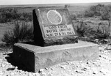
In 2005, final land acquisitions by the National Park Service
allowed official designation of the Sand Creek Massacre National Historic Site
, but no park facilities have yet been erected. Only a plaque in the ground acknowledges the site, and it appears that this stone plaque is located in the wrong place.
was unsustainable in this arid landscape, and the railroads were snaking west across the plains towards the gold fields of the Rocky Mountains
during the Colorado Gold Rush
. The Missouri Pacific Railroad
crossed into what would soon become Kiowa County, Colorado from Kansas in 1887.
 Several small camps for railroad workers were established just over the border from Kansas
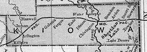
, and beginning after the town of Sheridan Lake
, new towns and camps were sequentially named, alphabetically, starting with "A" and proceeding westward along the railroad line.
Arden, Brandon
, Chivington
, Diston, Eads
, Fergus, Galatea, Haswell
, Inman, Joliet, and Kilburn appeared one after another, some developing into towns, others being only a pipe dream in the eyes of developers. Chivington was intended as a major watering stop for the railroad (a 60-room, $10,000 "crown jewel" hotel was initially built there), but the water was too alkaline to use and the trains instead stopped in Kansas to tank up. The hotel was soon torn down, its materials shipped to other Colorado locations to use in constructing other facilities — a common occurrence in late 19th century Colorado, as boom towns went bust.
Kiowa County was established in 1889, taking its name from the Kiowa Indians who lived in eastern Colorado before the Europeans arrived. Sheridan Lake was the county seat of Kiowa County, and was not at first a stop on the railroad line; only after local citizens built a railroad depot and turned it over to the Missouri Pacific did the railroad build a telegraph station and make Sheridan Lake a stop. The county seat moved to rival Eads in 1902.
 Agriculture in eastern Colorado collapsed in the dust bowl
days of the 1930s, today mostly dry-land farms and some ranching interests survive. Colorado's Front Range
cities and agriculture interests upstream have acquired most of the water rights, and the groundwater
aquifer
s are drying up; Kiowa County faces ever-decreasing water supplies and further economic decline.
It is conceivable that much of the county will eventually revert to its original sparse grassland
and prairie
conditions of the pre-1880s.
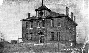
Today only Eads along the old railroad line remains as a town of much significance, Eads is the Kiowa county seat and serves the surviving farming and ranching interests, and hosts the county's largest high school. Sheridan Lake does have a combined junior-and-senior high, and still surviving in some form are Towner, Arlington, Brandon, Chivington, and Haswell.
of 2000, there were 1,622 people, 665 households, and 452 families residing in the county. The population density
was 1 people per square mile (0/km²). There were 817 housing units at an average density of 0 per square mile (0/km²). The racial makeup of the county was 96.12% White
, 0.49% Black
or African American
, 1.11% Native American
, 0.06% Pacific Islander
, 1.42% from other races
, and 0.80% from two or more races. 3.14% of the population were Hispanic
or Latino
of any race.
There were 665 households out of which 28.90% had children under the age of 18 living with them, 57.60% were married couples
living together, 6.60% had a female householder with no husband present, and 32.00% were non-families. 29.80% of all households were made up of individuals and 15.20% had someone living alone who was 65 years of age or older. The average household size was 2.40 and the average family size was 2.97.
In the county the population was spread out with 25.90% under the age of 18, 7.30% from 18 to 24, 24.70% from 25 to 44, 24.60% from 45 to 64, and 17.60% who were 65 years of age or older. The median age was 40 years. For every 100 females there were 100.00 males. For every 100 females age 18 and over, there were 97.40 males.
The median income for a household in the county was $30,494, and the median income for a family was $35,536. Males had a median income of $26,136 versus $18,897 for females. The per capita income
for the county was $16,382. About 9.60% of families and 12.20% of the population were below the poverty line, including 11.50% of those under age 18 and 13.80% of those age 65 or over.
Over 6% of the population were Quakers - one of the highest percentages in the country.
Colorado counties
The U.S state of Colorado is divided into 64 counties. Counties are important units of government in Colorado since the state has no secondary civil subdivisions, such as townships...
of the State of Colorado of the United States
United States
The United States of America is a federal constitutional republic comprising fifty states and a federal district...
. The county population was 1,622 at the 2000 census
United States Census, 2000
The Twenty-second United States Census, known as Census 2000 and conducted by the Census Bureau, determined the resident population of the United States on April 1, 2000, to be 281,421,906, an increase of 13.2% over the 248,709,873 persons enumerated during the 1990 Census...
. The county seat
County seat
A county seat is an administrative center, or seat of government, for a county or civil parish. The term is primarily used in the United States....
is Eads
Eads, Colorado
The Town of Eads is a Statutory Town that is the county seat and the most populous town of Kiowa County, Colorado, United States. The town population was 747 at the 2000 census...
. The county was named for the Kiowa Nation of Native Americans.
Sand Creek massacre
On November 29, 1864, more than a decade before Colorado became a state and long before Kiowa County was formed, a massacre of Native AmericansNative Americans in the United States
Native Americans in the United States are the indigenous peoples in North America within the boundaries of the present-day continental United States, parts of Alaska, and the island state of Hawaii. They are composed of numerous, distinct tribes, states, and ethnic groups, many of which survive as...
, a group of old men, women, and children, occurred on Sand Creek that initially was greeted as a victory in the Colorado War
Colorado War
The Colorado War was fought from 1863 to 1865 and was an Indian War between the Cheyenne and Arapaho tribes, against white settlers and militia in the Colorado Territory and adjacent regions...
against hostile Indians; within months, Congressional inquiries revealed the truth, and a national scandal erupted. It happened in what is now Kiowa County, and is known as the Sand Creek Massacre
Sand Creek Massacre
As conflict between Indians and white settlers and soldiers in Colorado continued, many of the Cheyenne and Arapaho, including bands under Cheyenne chiefs Black Kettle and White Antelope, were resigned to negotiate peace. The chiefs had sought to maintain peace in spite of pressures from whites...
.
Territorial Governor John Evans
John Evans (governor)
John Evans was a U.S. politician, physician, railroad promoter, Governor of the Territory of Colorado, and namesake of Evanston, Illinois; Evans, Colorado; and Mount Evans, Colorado...
eventually lost his job for his part in setting up the incident, and Colonel John Chivington
John Chivington
John Milton Chivington was a colonel in the United States Army who served in the American Indian Wars during the Colorado War and the New Mexico Campaigns of the American Civil War...
, commander of the U.S. forces, was castigated by the United States Congress
United States Congress
The United States Congress is the bicameral legislature of the federal government of the United States, consisting of the Senate and the House of Representatives. The Congress meets in the United States Capitol in Washington, D.C....
and the scandal followed him for the rest of his life. Evans would go on to make significant important contributions to the early Denver community and while Chivington also made some, his reputation remained tainted while Evans is still honored today.
In 2005, final land acquisitions by the National Park Service
National Park Service
The National Park Service is the U.S. federal agency that manages all national parks, many national monuments, and other conservation and historical properties with various title designations...
allowed official designation of the Sand Creek Massacre National Historic Site
Sand Creek Massacre National Historic Site
Sand Creek Massacre National Historic Site is a National Historic Site in Kiowa County, Colorado, near Eads and Chivington in Kiowa County commemorating the Sand Creek Massacre. The site is about southeast of Denver and about east of Pueblo. A few basic park facilities have been opened at this...
, but no park facilities have yet been erected. Only a plaque in the ground acknowledges the site, and it appears that this stone plaque is located in the wrong place.
Railroad and agriculture in the 1880s
In the late 1880s, eastern Colorado attracted a lot of attention by farming interests who didn't yet know that long-term agricultureAgriculture
Agriculture is the cultivation of animals, plants, fungi and other life forms for food, fiber, and other products used to sustain life. Agriculture was the key implement in the rise of sedentary human civilization, whereby farming of domesticated species created food surpluses that nurtured the...
was unsustainable in this arid landscape, and the railroads were snaking west across the plains towards the gold fields of the Rocky Mountains
Rocky Mountains
The Rocky Mountains are a major mountain range in western North America. The Rocky Mountains stretch more than from the northernmost part of British Columbia, in western Canada, to New Mexico, in the southwestern United States...
during the Colorado Gold Rush
Colorado Gold Rush
The Pike's Peak Gold Rush was the boom in gold prospecting and mining in the Pike's Peak Country of western Kansas Territory and southwestern Nebraska Territory of the United States that began in July 1858 and lasted until roughly the creation of the Colorado Territory on February 28, 1861...
. The Missouri Pacific Railroad
Missouri Pacific Railroad
The Missouri Pacific Railroad , also known as the MoPac, was one of the first railroads in the United States west of the Mississippi River. MoPac was a Class I railroad growing from dozens of predecessors and mergers, including the St. Louis, Iron Mountain and Southern Railway , Texas and Pacific...
crossed into what would soon become Kiowa County, Colorado from Kansas in 1887.
Kansas
Kansas is a US state located in the Midwestern United States. It is named after the Kansas River which flows through it, which in turn was named after the Kansa Native American tribe, which inhabited the area. The tribe's name is often said to mean "people of the wind" or "people of the south...
, and beginning after the town of Sheridan Lake
Sheridan Lake, Colorado
The Town of Sheridan Lake is a Statutory Town located in Kiowa County, Colorado, United States. The population was 66 at the 2000 census.-Geography:Sheridan Lake is located at ....
, new towns and camps were sequentially named, alphabetically, starting with "A" and proceeding westward along the railroad line.
Arden, Brandon
Brandon, Colorado
Brandon is a census-designated place in Kiowa County, Colorado, United States. The population as of the 2010 Census was 21. The U.S. Post Office at Sheridan Lake now serves Brandon postal addresses.-History:...
, Chivington
Chivington, Colorado
Chivington is an unincorporated town in Kiowa County, Colorado, United States. The U.S. Post Office at Eads now serves Chivington postal addresses....
, Diston, Eads
Eads, Colorado
The Town of Eads is a Statutory Town that is the county seat and the most populous town of Kiowa County, Colorado, United States. The town population was 747 at the 2000 census...
, Fergus, Galatea, Haswell
Haswell, Colorado
The Town of Haswell is a Statutory Town located in Kiowa County, Colorado, United States. The town population was 84 at the 2000 census.-Geography:Haswell is located at ....
, Inman, Joliet, and Kilburn appeared one after another, some developing into towns, others being only a pipe dream in the eyes of developers. Chivington was intended as a major watering stop for the railroad (a 60-room, $10,000 "crown jewel" hotel was initially built there), but the water was too alkaline to use and the trains instead stopped in Kansas to tank up. The hotel was soon torn down, its materials shipped to other Colorado locations to use in constructing other facilities — a common occurrence in late 19th century Colorado, as boom towns went bust.
Kiowa County was established in 1889, taking its name from the Kiowa Indians who lived in eastern Colorado before the Europeans arrived. Sheridan Lake was the county seat of Kiowa County, and was not at first a stop on the railroad line; only after local citizens built a railroad depot and turned it over to the Missouri Pacific did the railroad build a telegraph station and make Sheridan Lake a stop. The county seat moved to rival Eads in 1902.
Kiowa County today
Dust Bowl
The Dust Bowl, or the Dirty Thirties, was a period of severe dust storms causing major ecological and agricultural damage to American and Canadian prairie lands from 1930 to 1936...
days of the 1930s, today mostly dry-land farms and some ranching interests survive. Colorado's Front Range
Colorado Front Range
The Colorado Front Range is a colloquial geographic term for the most populous region of the state of Colorado in the United States. The area is located just east of the foothills of the Front Range, aligned in a north-south configuration on the western edge of the Great Plains, where they meet the...
cities and agriculture interests upstream have acquired most of the water rights, and the groundwater
Groundwater
Groundwater is water located beneath the ground surface in soil pore spaces and in the fractures of rock formations. A unit of rock or an unconsolidated deposit is called an aquifer when it can yield a usable quantity of water. The depth at which soil pore spaces or fractures and voids in rock...
aquifer
Aquifer
An aquifer is a wet underground layer of water-bearing permeable rock or unconsolidated materials from which groundwater can be usefully extracted using a water well. The study of water flow in aquifers and the characterization of aquifers is called hydrogeology...
s are drying up; Kiowa County faces ever-decreasing water supplies and further economic decline.
It is conceivable that much of the county will eventually revert to its original sparse grassland
Grassland
Grasslands are areas where the vegetation is dominated by grasses and other herbaceous plants . However, sedge and rush families can also be found. Grasslands occur naturally on all continents except Antarctica...
and prairie
Prairie
Prairies are considered part of the temperate grasslands, savannas, and shrublands biome by ecologists, based on similar temperate climates, moderate rainfall, and grasses, herbs, and shrubs, rather than trees, as the dominant vegetation type...
conditions of the pre-1880s.
Today only Eads along the old railroad line remains as a town of much significance, Eads is the Kiowa county seat and serves the surviving farming and ranching interests, and hosts the county's largest high school. Sheridan Lake does have a combined junior-and-senior high, and still surviving in some form are Towner, Arlington, Brandon, Chivington, and Haswell.
Geography
According to the 2000 census, the county has a total area of 1785.76 square miles (4,625.1 km²), of which 1770.99 square miles (4,586.8 km²) (or 99.17%) is land and 14.76 square miles (38.2 km²) (or 0.83%) is water.Adjacent counties
- Cheyenne CountyCheyenne County, ColoradoCheyenne County is the fifth least densely populated of the 64 counties of the state of Colorado of the United States. The county population was 2,231 at U.S. Census 2000...
, ColoradoColoradoColorado is a U.S. state that encompasses much of the Rocky Mountains as well as the northeastern portion of the Colorado Plateau and the western edge of the Great Plains...
- north - Greeley CountyGreeley County, KansasGreeley County is a county located in West Central Kansas, in the Central United States. As of the 2010 census, the county population was 1,247, which is the lowest in Kansas. Its county seat and largest town is Tribune...
, KansasKansasKansas is a US state located in the Midwestern United States. It is named after the Kansas River which flows through it, which in turn was named after the Kansa Native American tribe, which inhabited the area. The tribe's name is often said to mean "people of the wind" or "people of the south...
- east - Bent CountyBent County, ColoradoBent County is one of the 64 counties of the state of Colorado of the United States. The county is named in honor of frontier trader William Bent. The county population was 5,998 at U.S. Census 2000...
, ColoradoColoradoColorado is a U.S. state that encompasses much of the Rocky Mountains as well as the northeastern portion of the Colorado Plateau and the western edge of the Great Plains...
- south - Prowers CountyProwers County, ColoradoProwers County is one of the 64 counties of the State of Colorado of the United States. The county is named in honor of John W. Prowers, a leading pioneer in the lower Arkansas valley region. The county population was 14,483 at U.S. Census 2000...
, ColoradoColoradoColorado is a U.S. state that encompasses much of the Rocky Mountains as well as the northeastern portion of the Colorado Plateau and the western edge of the Great Plains...
- south - Otero CountyOtero County, ColoradoOtero County is one of the 64 counties of the State of Colorado of the United States. The county was named for Miguel Antonio Otero, one of the founders of the town of La Junta and a member of a prominent Hispanic family. The county population was 20,311 at U.S. Census 2000...
, ColoradoColoradoColorado is a U.S. state that encompasses much of the Rocky Mountains as well as the northeastern portion of the Colorado Plateau and the western edge of the Great Plains...
- southwest - Crowley CountyCrowley County, ColoradoCrowley County is one of the 64 counties of the State of Colorado of the United States. The county population was 5,518 at U.S. Census 2000. The county seat is Ordway.- History :...
, ColoradoColoradoColorado is a U.S. state that encompasses much of the Rocky Mountains as well as the northeastern portion of the Colorado Plateau and the western edge of the Great Plains...
- west - Lincoln CountyLincoln County, ColoradoLincoln County is the tenth most extensive of the 64 counties of the State of Colorado of the United States. The county population was 6,087 at U.S. Census 2000...
, ColoradoColoradoColorado is a U.S. state that encompasses much of the Rocky Mountains as well as the northeastern portion of the Colorado Plateau and the western edge of the Great Plains...
- northwest
Demographics
As of the censusCensus
A census is the procedure of systematically acquiring and recording information about the members of a given population. It is a regularly occurring and official count of a particular population. The term is used mostly in connection with national population and housing censuses; other common...
of 2000, there were 1,622 people, 665 households, and 452 families residing in the county. The population density
Population density
Population density is a measurement of population per unit area or unit volume. It is frequently applied to living organisms, and particularly to humans...
was 1 people per square mile (0/km²). There were 817 housing units at an average density of 0 per square mile (0/km²). The racial makeup of the county was 96.12% White
Race (United States Census)
Race and ethnicity in the United States Census, as defined by the Federal Office of Management and Budget and the United States Census Bureau, are self-identification data items in which residents choose the race or races with which they most closely identify, and indicate whether or not they are...
, 0.49% Black
Race (United States Census)
Race and ethnicity in the United States Census, as defined by the Federal Office of Management and Budget and the United States Census Bureau, are self-identification data items in which residents choose the race or races with which they most closely identify, and indicate whether or not they are...
or African American
Race (United States Census)
Race and ethnicity in the United States Census, as defined by the Federal Office of Management and Budget and the United States Census Bureau, are self-identification data items in which residents choose the race or races with which they most closely identify, and indicate whether or not they are...
, 1.11% Native American
Race (United States Census)
Race and ethnicity in the United States Census, as defined by the Federal Office of Management and Budget and the United States Census Bureau, are self-identification data items in which residents choose the race or races with which they most closely identify, and indicate whether or not they are...
, 0.06% Pacific Islander
Race (United States Census)
Race and ethnicity in the United States Census, as defined by the Federal Office of Management and Budget and the United States Census Bureau, are self-identification data items in which residents choose the race or races with which they most closely identify, and indicate whether or not they are...
, 1.42% from other races
Race (United States Census)
Race and ethnicity in the United States Census, as defined by the Federal Office of Management and Budget and the United States Census Bureau, are self-identification data items in which residents choose the race or races with which they most closely identify, and indicate whether or not they are...
, and 0.80% from two or more races. 3.14% of the population were Hispanic
Race (United States Census)
Race and ethnicity in the United States Census, as defined by the Federal Office of Management and Budget and the United States Census Bureau, are self-identification data items in which residents choose the race or races with which they most closely identify, and indicate whether or not they are...
or Latino
Race (United States Census)
Race and ethnicity in the United States Census, as defined by the Federal Office of Management and Budget and the United States Census Bureau, are self-identification data items in which residents choose the race or races with which they most closely identify, and indicate whether or not they are...
of any race.
There were 665 households out of which 28.90% had children under the age of 18 living with them, 57.60% were married couples
Marriage
Marriage is a social union or legal contract between people that creates kinship. It is an institution in which interpersonal relationships, usually intimate and sexual, are acknowledged in a variety of ways, depending on the culture or subculture in which it is found...
living together, 6.60% had a female householder with no husband present, and 32.00% were non-families. 29.80% of all households were made up of individuals and 15.20% had someone living alone who was 65 years of age or older. The average household size was 2.40 and the average family size was 2.97.
In the county the population was spread out with 25.90% under the age of 18, 7.30% from 18 to 24, 24.70% from 25 to 44, 24.60% from 45 to 64, and 17.60% who were 65 years of age or older. The median age was 40 years. For every 100 females there were 100.00 males. For every 100 females age 18 and over, there were 97.40 males.
The median income for a household in the county was $30,494, and the median income for a family was $35,536. Males had a median income of $26,136 versus $18,897 for females. The per capita income
Per capita income
Per capita income or income per person is a measure of mean income within an economic aggregate, such as a country or city. It is calculated by taking a measure of all sources of income in the aggregate and dividing it by the total population...
for the county was $16,382. About 9.60% of families and 12.20% of the population were below the poverty line, including 11.50% of those under age 18 and 13.80% of those age 65 or over.
Over 6% of the population were Quakers - one of the highest percentages in the country.
Cities and towns
- ArlingtonArlington, ColoradoArlington is an unincorporated town and U.S. Post Office in Kiowa County, Colorado, United States. The ZIP Code of the Arlington Post Office is 81021.-History:The town of Arlington was established by the Missouri Pacific Railroad in 1887...
- BrandonBrandon, ColoradoBrandon is a census-designated place in Kiowa County, Colorado, United States. The population as of the 2010 Census was 21. The U.S. Post Office at Sheridan Lake now serves Brandon postal addresses.-History:...
- ChivingtonChivington, ColoradoChivington is an unincorporated town in Kiowa County, Colorado, United States. The U.S. Post Office at Eads now serves Chivington postal addresses....
- EadsEads, ColoradoThe Town of Eads is a Statutory Town that is the county seat and the most populous town of Kiowa County, Colorado, United States. The town population was 747 at the 2000 census...
- HaswellHaswell, ColoradoThe Town of Haswell is a Statutory Town located in Kiowa County, Colorado, United States. The town population was 84 at the 2000 census.-Geography:Haswell is located at ....
- Sheridan LakeSheridan Lake, ColoradoThe Town of Sheridan Lake is a Statutory Town located in Kiowa County, Colorado, United States. The population was 66 at the 2000 census.-Geography:Sheridan Lake is located at ....
- TownerTowner, ColoradoTowner is a census-designated place in Kiowa County, Colorado, United States. The population as of the 2010 Census was 22. The U.S. Post Office at Sheridan Lake now serves Towner postal addresses. The town was originally known as Memphis. It was a frequent attraction for Kansans when their...
See also
- Colorado census statistical areas
- Colorado countiesColorado countiesThe U.S state of Colorado is divided into 64 counties. Counties are important units of government in Colorado since the state has no secondary civil subdivisions, such as townships...
- Colorado municipalitiesColorado municipalitiesThe U.S. state of Colorado currently has 271 active incorporated municipalities, including 196 towns, 73 cities, and two consolidated city and county governments.-Municipal government:...
- National Register of Historic Places listings in Kiowa County, Colorado