
Kakadu National Park
Encyclopedia
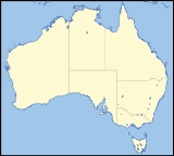
Kakadu National Park is in the Northern Territory
of Australia
, 171 km southeast of Darwin
.
Kakadu National Park is located within the Alligator Rivers
Region of the Northern Territory of Australia. It covers an area of 19804 km² (7,646.4 sq mi), extending nearly 200 kilometres from north to south and over 100 kilometres from east to west. It is the size of Slovenia
, about one-third the size of Tasmania
, or nearly half the size of Switzerland
. The Ranger Uranium Mine
, one of the most productive Uranium mines in the world, is contained within the park.
, which is the name of an Aboriginal language
formerly spoken in the northern part of the Park. Kakadu is ecologically and biologically diverse. The main natural features protected within the National Park include:
Aboriginal people have occupied the Kakadu area continuously for at least 40 000 years. Kakadu National Park is renowned for the richness of its Aboriginal cultural sites. There are more than 5000 recorded art sites illustrating Aboriginal culture over thousands of years. The archaeological sites demonstrate Aboriginal occupation for at least 20 000 and possibly up to 40 000 years.
The cultural and natural values of Kakadu National Park were recognised internationally when the Park
was placed on the UNESCO
World Heritage List. This is an international register of properties that are recognised as having outstanding cultural or natural values of international significance. Kakadu was listed in three stages: Stage 1 in 1981, Stage 2 in 1987, and the entire Park in 1992.
Approximately half of the land in Kakadu is aboriginal land under the Aboriginal Land Rights (Northern Territory) Act 1976 and most of the remaining land is currently under claim by Aboriginal people. The areas of the Park that are owned by Aboriginal people are leased by the traditional owners to the Director of National Parks to be managed as a national park. The remaining area is Commonwealth
land vested under the Director of National Parks. All of Kakadu is declared a national park under the Environment Protection and Biodiversity Conservation Act 1999.
The Aboriginal traditional owners of the Park are descendants of various clan groups from the Kakadu area and have longstanding affiliations with this country. Their lifestyle has changed in recent years, but their traditional customs and beliefs remain very important. About 500 Aboriginal people live in the Park; many of them are traditional owners. All of Kakadu is jointly managed by Aboriginal traditional owners and the Australian Government’s Department of the Environment and Water Resources through a division known as Parks Australia. Park Management is directed by the Kakadu Board of Management.
region was proposed as early as 1965, but took until 1978 for the Australian Government
to make arrangements to acquire the titles over various tracts of land that now constitute Kakadu National Park.
Kakadu National Park was declared under the National Parks and Wildlife Conservation Act 1975 (NPWC Act) in three stages between 1979 and 1991. The NPWC Act was replaced by the EPBC Act in 2000. The declaration of the Park continues under the EPBC Act. Each stage of the Park includes Aboriginal land under the Land Rights Act that is leased to the Director of National Parks or land that is subject to a claim to traditional ownership under the Land Rights Act. Most of the land that was to become part of Stage One of Kakadu was granted to the Kakadu Aboriginal land Trust under the Land Rights Act in August 1978 and, in November 1978, the Land Trust and the Director signed a lease for the land to be managed as a national park. Stage One of the Park was declared on 5 April 1979.
Stage Two was declared on 28 February 1984. In March 1978, a claim was lodged under the Land Rights Act for the land included in Stage Two of Kakadu. The land claim was partly successful and, in 1986, three areas in the eastern part of Stage Two were granted to the Jabiluka Aboriginal Land Trust. A lease between the Land Trust and the Director of National parks was signed in March 1991.
In 1987, a land claim was lodged for the land in the former Goodparla and Gimbat pastoral that that were to be included in Stage Three of Kakadu. The other area to be included in Stage Three – the area known as the Gimbat Resumption and the Waterfall Creek Reserve were later added to this land claim. The progressive declaration was due to the debate over whether mining should be allowed at Guratba (Coronation Hill) which is located in the middle of the area referred to as Sickness Country.
The traditional owners’ wishes were ultimately respected and the Australian National Government decided that there would be no mining at Guratba.
In 1996, the land in Stage Three, apart from the former Goodparla pastoral leases, was granted to the Gunlom Aboriginal Land Trust and leased to the Director of National Parks to continue being managed as part of Kakadu.
, Malays and Portuguese
all claim to have been the first non-Aboriginal explorers of Australia’s north coast. The first surviving written account comes from the Dutch
. In 1623 Jan Carstenz made his way west across the Gulf of Carpentaria
to what is believed to be Groote Eylandt. Abel Tasman
is the next documented explorer to visit this part of the coast in 1644. He was the first person to record European contact with Aboriginal people. Almost a century later Matthew Flinders
surveyed the Gulf of Carpentaria in 1802 and 1803.
.jpg) Phillip Parker King, an English navigator entered the Gulf of Carpentaria between 1818 and 1822. During this time he named the three Alligator Rivers after the large numbers of crocodiles
Phillip Parker King, an English navigator entered the Gulf of Carpentaria between 1818 and 1822. During this time he named the three Alligator Rivers after the large numbers of crocodiles
, which he mistook for alligator
s.
Ludwig Leichhardt
was the first land-based European explorer to visit the Kakadu region, in 1845 on his route from Moreton Bay
in Queensland
to Port Essington
in the Northern Territory. He followed Jim Jim Creek down from the Arnhem Land
escarpment, then went down the South Alligator before crossing to the East Alligator and proceeding north. A more plausible, if prosaic, explanation for the origin of the name of the park is that Leichardt applied the colloquial German term for a cockatoo, although this is unlikely to sit well with the indigenous historians.
 In 1862 John McDouall Stuart
travelled along the south-western boundary of Kakadu but did not see any people.
The first non-Aboriginal people to visit and have sustained contact with Aboriginal people in northern Australia were the Macassans from Sulawesi
and other parts of the Indonesia
n archipelago. They travelled to northern Australia every wet season, probably from the last quarter of the seventeenth century, in sailing boats called praus. Their main aim was to harvest trepang (sea cucumber
), turtle shell, pearl
s and other prized items to trade in their homeland. Aboriginal people were involved in harvesting and processing the trepang, and in collecting and exchanging the other goods.
There is no evidence that the Macassans
spent time on the coast of Kakadu but there is evidence of some contact between Macassan culture and Aboriginal people of the Kakadu area. Among the artefacts from archaeological digs in the Park are glass and metal fragments that probably came from the Macassans, either directly or through trade with the Coburg Peninsula people.
The British
attempted a number of settlements on the northern Australian coast in the
early part of the nineteenth century: Fort Dundas on Melville Island in 1824; Fort Wellington
at Raffles Bay in 1829; and Victoria Settlement (Port Essington) on the Coburg Peninsula in 1838. They were anxious to secure the north of Australia before the French or Dutch, who had colonised islands further north. The British settlements were all subsequently abandoned for a variety of reasons, such as lack of water and fresh food, sickness and isolation.
It is difficult to assess the impact of these settlements on the local Aboriginal people and the type of relationship that developed between them and the British. Certainly, some Aboriginal labour was used at the settlements. Exposure to new sickness was an ever-present danger. As in other parts of Australia, disease and the disruption it caused to society devastated the local Aboriginal population.
The industry began on the Adelaide River, close to Darwin, and moved east to the Mary River
and Alligator Rivers regions.
Most of the buffalo hunting and skin curing was done in the dry season, between June and September, when buffaloes congregated around the remaining billabong
s.
During the wet season hunting ceased because the ground was too muddy to pursue buffalo and the harvested hides would rot. The buffalo-hunting industry became an important employer of Aboriginal people during the dry-season months.
The extent to which missions have influenced Aboriginal society is the subject of debate. Some writers and anthropologists argue that missionaries, in seeking to ‘civilise and institutionalise’ Aboriginal people, forced them to abandon their lifestyle, language, religion and ceremonies—indeed, the whole fabric of their lives. Others argue that, although criticism can be levelled at the methods used to achieve their goal, the missionaries did care about the welfare of Aboriginal people at a time when wider Australian society did not.
In southern Kakadu much of Goodparla and Gimbat was claimed in the mid-1870s by three pastoralists, Roderick, Travers and Sergison. The leases were subsequently passed on to a series of owners, all of whom were unable for one reason or another to make a go of it. In 1987 both stations were acquired by the Commonwealth and incorporated in Kakadu National Park.
A sawmill at Nourlangie Camp was begun by Chinese operators, probably before World War I
, to mill stands of cypress pine in the area. After World War II a number of small-scale ventures, including dingo shooting and trapping, brumby
shooting, crocodile shooting, tourism and forestry, began.
Nourlangie Camp was again the site of a sawmill in the 1950s, until the local stands of cypress pine were exhausted. In 1958 it was converted into a safari camp for tourists. Soon after, a similar camp was started at Patonga and at Muirella Park. Clients were flown in for recreational buffalo and crocodile hunting and fishing.
Crocodile hunters often made use of the bush skills of Aboriginal people. By imitating a wallaby’s tail hitting the ground, Aboriginal hunters could attract crocodiles, making it easier to shoot the animals. Using paperbark rafts, they would track the movement of a wounded crocodile and retrieve the carcass for skinning. The skins were then sold to make leather goods. Aboriginal people became less involved in commercial hunting of crocodiles once the technique of spotlight shooting at night developed. Freshwater Crocodile
s have been protected by law since 1964 and Saltwater Crocodile
s since 1971.
 The first mineral discoveries in the Top End were associated with the construction of the Overland Telegraph line between 1870 and 1872, in the Pine Creek – Adelaide River
area. A series of short mining booms followed.
The construction of the North Australia Railway line gave more permanency to the mining
camps, and places such as Burrundie and Pine Creek became permanent settlements. The mining camps and new settlements drew many Aboriginal people away from Kakadu. No Aboriginal people are known to have worked in the mines but their exposure to alcohol and other drugs had a huge impact.
Small-scale gold
mining began at Imarlkba, near Barramundi Creek, and Mundogie Hill in the 1920s and at Moline (previously called Eureka and Northern Hercules mine), south of the Park, in the 1930s. The mines employed a few local Aboriginal people.
In 1953 uranium
was discovered along the headwaters of the South Alligator River valley. Thirteen small but rich uranium mines operated in the following decade, at their peak in 1957 employing over 150 workers. No Aboriginal people were employed at any of these mines.
Early in the 1970s large uranium deposits were discovered at Ranger, Jabiluka
and Koongarra. Following receipt of a formal proposal to develop the Ranger site, the Commonwealth Government initiated an inquiry into land use in the Alligator Rivers region. The Ranger Uranium Environmental Inquiry (known as the Fox inquiry
) recommended, among other things, that mining begin at the Ranger
site, that consideration be given to the future development of the Jabiluka and Koongarra sites, and that a service town be built (Fox et al. 1976, 1977). The Ranger mine and the service town (Jabiru
) have had many and considerable impacts on Aboriginal people. Aboriginal people express varying opinions about mining.
 Kakadu is located in the tropics, between 12° and 14° south of the Equator
. The climate is monsoonal,
characterised by two main seasons: the dry season
and the rain season. The 'build up' describes the transition between the dry and the rain. During the dry season (from April/May to September), dry southerly and easterly trade winds predominate. Humidity is relatively low and rain is unusual. At Jabiru, the average maximum temperature for June-July is 32 °C.During the 'build up' (October to December) conditions can be extremely uncomfortable with high temperatures and high humidity. However, 'build up' storms are impressive and lightning strikes are frequent. In fact, the Top End of Australia records more lightning strikes per year than any other place on earth. At Jabiru the average maximum temperature for October is 37.5 °C.
The rain season (January to March/April) is characterised by warm temperatures and, as one would expect, rain. Most of the rain is associated with monsoonal troughs formed over Southeast Asia, although occasionally tropical
cyclone
s produce intense heavy rain over localised areas. At Jabiru, the average maximum temperature for January is 33 °C.Annual rainfall in Kakadu National Park ranges from 1,565 mm in Jabiru to 1,300 mm in the Mary River region.
Most non Aboriginal people really only refer to the rain and dry seasons, but Aboriginal people Bininj/Mungguy identify as many as six seasons in the Kakadu region:
Periods of torrential rain and long dry spells mean that Kakadu can change its appearance according to the season, so is a place deserving of more than one visit.
with more than 1700 plant species
recorded which is a result of the Park's geological, landform and habitat diversity. Kakadu is also considered to be one of the most weed free national parks in the world.
The distinctly different geographical areas of Kakadu have their own specialised flora. The environment
referred to as ‘the Stone Country’ features ‘resurrection grasses’ that are able to cope with extreme heat and long dry spells followed by periods of torrential rain. Monsoon forests often develop in the cool moist gorges dissecting the stone country. The southern hills and basins support several endemic
plants that are only found in Kakadu such as Eucalyptus koolpinensis near Jarrangbarnmi (Koolpin Gorge). Lowland areas form a large proportion of Kakadu National Park and are mainly covered in eucalypt-dominated open woodland with the ground layer consisting of a large range of grasses including spear grass
, sedges and wildflowers.
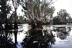
The floodplain
s, which are inundated for several months each year, feature sedges such as spike rush as well patches of freshwater mangrove
s (itchy tree), pandanus
and paper bark trees (Melaleuca
). Varieties of water lilies
, such as the blue, yellow and white snowflake, are commonly found in these areas. Estuaries and tidal flats are populated with varieties of mangroves (39 of the 47 Northern Territory species of mangrove occur in Kakadu) that are important for stabilising the coastline. Mangrove
s serve as feeding and breeding grounds for many fish species including the barramundi
.
On the tidal flats behind the mangroves, hardy succulents (samphire
), grasses and sedges grow. Isolated pockets of monsoon forest grow along the coast and river banks. These forests contain several impressive trees, among them the banyan
fig, which can be recognised by its large, spreading aerial roots, and the kapok tree, which has a spiny trunk, large, waxy red flowers and pods full of cotton-like material.
 The diverse environments of Kakadu National Park support an astonishing array of animals, a number of which have adapted to particular habitats. Some animals in the Park are rare, endangered, vulnerable or endemic. Responding to the extreme weather conditions experienced in the Park, many animals are active only at particular times of the day or night or at particular times of the year.
species—marsupials and placental mammals—have been recorded in the Park. Most of them inhabit the open forest and woodlands and are nocturnal, making it difficult to see them. Others, such as wallabies
and kangaroo
s (macropods, 8 species), are active in the cooler parts of the day and are easier to see.
Among the larger more common species are Dingo
s, Antilopine Kangaroo
s, Black Wallaroos, Agile Wallaby
s, and Short-eared Rock Wallabys. Smaller common mammals are northern quoll
s, brush-tailed phascogale
s, brown bandicoots, black-footed tree-rats, and black fruit bats. Dugong
s are found in the coastal waters. However, recent surveys have revealed a disturbing decline of nearly all mammal species throughout Kakadu, including once common and widespread species such as northern quolls.
Some 11,246 km2 of Kakadu’s savanna
habitats has been identified by BirdLife International
as an Important Bird Area
(IBA) because it supports populations of the endangered Gouldian Finch
, the vulnerable
Red Goshawk
, the near threatened
Partridge Pigeon
and Chestnut-backed Button-quail
, and the restricted-range Hooded Parrot
and Rainbow Pitta
. The Kakadu Savanna IBA also supports Varied Lorikeet
s, Northern Rosella
s, Silver-crowned Friarbird
s, White-gaped
, Yellow-tinted
, White-lined
, Bar-breasted
and Banded Honeyeater
s, Sandstone Shrike-thrush
es, White-browed Robin
s, Canary White-eyes, and Masked
and Long-tailed Finch
es.
Two species of crocodile
occur in Kakadu: the Freshwater Crocodile (Crocodylus johnstonii) and the Estuarine, or Saltwater Crocodile (C. porosus). Freshwater Crocodiles are easily identified by their narrow snout and a single row of four large boney lumps called ‘scutes’ immediately behind the head. Estuarine Crocodiles do not have these scutes and their snout is broader. The maximum size for a ‘freshie’ is 3 metres, whereas a ‘saltie’ can exceed 6 metres.
species are extremely well adapted to the region’s climatic extremes. Many remain dormant during rainless times. With the onset of the wet season, when the billabong
s and swamps start to fill with water, the night air is filled with the sounds of frogs such as the northern bullfrog and the marbled frog. As the water builds up, frogs and tadpoles have an abundance of food, such as algae, vegetation, insects, dragonfly nymphs, and other tadpoles. Not all of Kakadu’s frogs are found in the wetlands: many live in the lowland forests.
have been recorded in Kakadu’s waterways; eight of them have a restricted distribution. In the Magela Creek system alone, 32 species have been found. In comparison, the Murray–Darling river system, the most extensive in Australia, now supports only 27 native fish species. Although introduced fish have been found in most Australian waterways, none have been recorded in the Park.
s, beetles, flies, termite
s, butterflies
and moth
s, bee
s, wasp
s, ant
s, dragonflies
and damselflies
, caddis flies, non-biting midges and mayflies
. The great variety of insects is a result of the varied habitats and relatively high temperatures throughout the year.
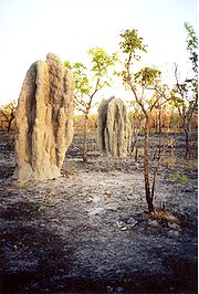
Perhaps the most striking insect-created features in the Park are the termite mounds. The mounds in the southern part of the Park are particularly large and impressive. Leichhardt’s grasshopper, in colours of orange, blue and black, is perhaps the most spectacular insect found in Kakadu. It is also found on the Arnhem Land plateau and in Gregory National Park.
have had major effects on habitat. Invasive weeds include Mimosa pigra
, which covers 800 km² of the Top End, including vast areas of Kakadu, invasive paragrass displaces the native food of much of Kakadu's birdlife. Salvinia molesta has infested the Magela floodplain. Brumbies
also inhabit areas of the National Park, including Yellow Water.
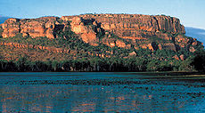
Most of Kakadu was under a shallow sea approximately 140 million years ago, with the escarpment wall formed from sea cliffs and Arnhem Land from a flat plateau above the sea. Currently the escarpment rises 330 metres above the plateau and extends approximately 500 kilometres along the East edge of the park and on into Arnhem Land. The escarpment varies from near vertical cliffs in the Jim Jim Falls
area to isolated outliers and stepped cliffs in the North.
Chasms and gorges form a network that dissects the rocky platforms on the plateau. The plateau top is a harsh, dry environment where water drains away quickly and top soil is scarce in most areas. Sparse pockets of open forest and woodlands have developed in these areas. However creeks have carved deep gorges in the escarptment in which tall monsoon forests grow. These areas form microclimate
s for plants and animals and often serve as a refuge during the dry season. Allosyncarpia
ternata, a large shady tree found only in the Kakadu and Arnhem Land, is the dominant plant species.
The outliers are essentially pieces of the Arnhem Land plateau that have become separated from the plateau complex by erosion. They were islands in the ancient seas that once covered much of Kakadu. The gently undulating lowland plains stretch over much of the Top End. Travelling anywhere in Kakadu, you cannot help noticing the lowlands—they make up nearly 70% of the Park. The soils are shallow and often overlie extensive sheets of laterite (ironstone) and a thick profile of strongly leached rocks.
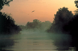
During the wet season
, water carried down from the Arnhem Land plateau often overflows from creeks and rivers onto nearby floodplains. Alluvial soils carried in the floodwaters add nutrients to the floodplains. Nutrient-rich soils along with an abundance of water and sunlight make the floodplains an area of prolific plant and animal life. During the dry season the water recedes into rivers, creeks and isolated waterholes or billabong
s. Kakadu’s wetlands are listed under the Convention on Wetlands of International Importance (the Ramsar Convention) for their outstanding ecological, botanical, zoological and hydrological features.
The southern hills and basins cover a large area in the south of the Park, including the headwaters of the South Alligator River. Rocks here have been exposed from beneath the retreating Arnhem escarpment; they are of volcanic origin and are extremely old (2500 million years). This landform is characterised by rugged strike ridges separated by alluvial flats.
 Kakadu’s coast and the creeks and river systems under tidal influence (extending about 100 kilometres inland) make up this landform. The shape of the estuaries and tidal flats varies considerably from the dry season to the wet season. During the dry season tidal action deposits silt along the river beds and banks. During the wet season the river beds are eroded by the floodwaters and large quantities of fresh and saline water flow out across the tidal flats, where silt is deposited. Large silt loads are also carried out to sea, some of the silt being deposited as a nutrient rich layer on the sea floor, contributing to the muddy waters that characterise Kakadu’s coastline.
The estuaries and tidal flats are home to an array of plants and animals adapted to living in the oxygen-deficient saline mud. The dominant habitats are mangrove swamps and samphire flats. Where freshwater springs occur along the coasts and river banks, isolated pockets of coastal monsoon rainforests form.
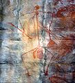
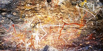 The art sites of Ubirr
, Burrunguy (Nourlangie Rock) and Nanguluwu
r are internationally recognised as outstanding examples of Aboriginal rock art. These sites are found in rocky outcrops that have afforded shelter to Aboriginal inhabitants for thousands of years. The painting in these rock shelters were done for various reasons:
 Ubirr is a group of rock outcrops in the northeast of the park, on the edge of the Nadab floodplain. There several large rock overhangs that would have provided excellent shelter to Aboriginal people over thousands of years. Ubirr’s proximity to the East Alligator River and Nadab floodplains means that food would have been abundant and this is reflected in much of the rock art here. Animals depicted in the main gallery include barramundi
, catfish
, mullet
, goanna
, snake-necked turtle
, pig-nosed turtle, Rock-haunting Ringtail Possum
, and wallaby
and thylacine
(Tasmanian Tiger).
There are also images of the Rainbow Serpent said to have created much of the landscape as well as mischievous Mimi spirits and the story of the Namarrgarn Sisters. Many stories connected to Aboriginal rock are highly complex and linked to other stories. Often the true meanings have been lost, but they all have a purpose which is usually to serve as a lesson or a warning to the young or to those passing through the area.
Burrunguy, formally called Nourlangie Rock, is located in an outlying formation of the Arnhem Land Escarpment. There are a number of shelters in amongst this large outcrop linked by paths and stairways. The shelters contain several impressive paintings that deal with creation ancestors. Some of the stories connected to these artworks are known only to certain Aboriginal people and remain secret.
Anbangbang Billabong
lies in the shadow of Nourlangie Rock and is inhabited by a wide range of wildlife which would have sustained traditional Aboriginal people well.
Nanguluwur is a small art site, near Nourlangie, which displays several rock art styles. These include hand stencils, dynamic figures in large head-dresses carrying spears and boomerangs, representations of Namandi spirits and mythical figures, including Alkajko, a female spirit with four arms and horn-like protuberances. There is also an interesting example of ‘contact art’ depicting a two-masted sailing ship with anchor chain and a dinghy trailing behind.
has resulted in damage to the fragile floodplains and wetlands. Since then, buffalo have largely been eradicated from the area so the land is now rehabilitating itself. Crocodile hunting which has been banned since 1972 made a huge impact on crocodile populations. In the 30 or so years that they have been protected, however the crocodile population has recovered so successfully that some consider there to be an over population.
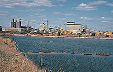
Mining has an obvious impact on the landscape, but only one operational uranium mine (Ranger
) remains. Mine operators are required to completely rehabilitate the area once the operation is wound down. Some small scale logging occurred in the early part of the 20th century, but little evidence of this remains. Tourism represents a significant human impact to Kakadu National Park with hundreds of thousands of visitors arriving annually. Infrastructure such as roads, tracks, interpretive signage and shelter, accommodation, telecommunications and other services must be provided to support this activity.
Controlled burning is practiced by the national park in consultation with traditional owners who have used fire as a land management tool for thousands of years. Fire is an important hunting tool for Aboriginal people using it to flush out prey. The other benefit is that once the fire has gone through an area the tender shoots of the fast regenerating grasses attract wallabies into a clearly defined area. Birds of prey such as Whistling Kites also rely on fire to flush out small animals and are usually found in large numbers circling a fire front. Other species such as white-throated grasswrens have declined because of too many fires. Aboriginal people understand that fire is necessary to ‘clean up’ the landscape and believe that many small fires are preferable to one large fire.
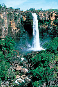
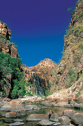
s and gorges within the Park that are popular with visitors such as Maguk
, Gunlom, Twin Falls
and Jim Jim Falls
.
Kakadu National Park has some of the best examples of Aboriginal rock art in Australia. The sites of Nourlangie and Ubirr are among the most visited locations in the Park. It is possible to view some of Kakadu’s diverse wildlife at places like Yellow Water Billabong, Cooinda on board a wildlife cruise or at Mamukala Wetlands or Anbangbang Billabong. The Kakadu region is one of the world’s best for bird watching as approximately 30 percent of Australia’s bird species can be seen here.
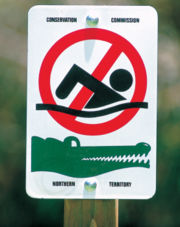 Large saltwater crocodile
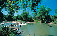
s are also commonplace and visitors are likely to see them at Yellow Water and East Alligator River so it was no coincidence that the Crocodile Dundee films were shot here. Visitors are urged to exercise caution around crocodiles as they have been responsible for a number of fatal attacks. Recreational fishing is a popular activity inside Kakadu National Park. The main target species is Barramundi and the most popular locations are Yellow Water, the South Alligator and the East Alligator River. Hunting is not allowed in Kakadu National Park.
There are several accommodation options in the Park, mostly found in the town of Jabiru, as well as a range of services to cater to visitor’s needs. Visitors can experience Kakadu National Park with a recognised tour operator or they can drive themselves. Many of the Park’s sites are accessible by standard two wheel drive vehicles, but areas like Twin and Jim Jim Falls and Gunlom require four wheel drive vehicles. Visitors can experience Kakadu National Park via the Nature’s Way tourism drive which is a loop from Darwin to Jabiru then onto Katherine
and back to Darwin covering approximately 900km.
 The EPBC Act provides for boards of management to be established for parks on Aboriginal land. The Kakadu Board of Management, which has an Aboriginal majority (ten out of fifteen members), representing the Aboriginal traditional owners of land in the Park, was established in 1989. The Board determines policy for managing the Park and is responsible, along with the Director, for preparing plans of management for the Park. The Plan of Management is the main policy document for the Park and strives to balance strategic or long-term goals and tactical or day to day goals.
Day to day management of Kakadu is carried out by people employed by Parks Australia, which is a branch of the Australian Government’s Department of Sustainability, Environment, Water, Population and Communities. Approximately one-third of the staff in Kakadu are Aboriginal people.
Like many World Heritage sites around the world, including Yellowstone National Park, Serengeti National Park, Stonehenge, Pompeii and Herculaneum and the Pyramids of Egypt - the park use fee helps to maintain world-best management practices and facilities for the more than 200,000 visitors who experience Kakadu each year.
The $25 fee (which is inclusive of GST) applies to all interstate and international visitors aged 16 years and over. All Northern Territory residents and children under 16 are exempt.
Tickets and more information will be available on the Kakadu National Park tourism website.
and Katherine by the Kakadu Highway. Both roads are sealed all weather roads although may be cut off periodically during periods of heavy rain.
The town of Jabiru has several accommodation options, a service station, police, a medical clinic and a shopping centre with a range of outlets. The town was built for the Uranium mine that was established prior to the founding of Kakadu National Park and provides infrastructure for the mine’s workforce as well as the national park activities and tourism. Jabiru has a small airport from which scenic flights operate daily. There are no scheduled air services between Jabiru and Darwin however.
Other small tourism centres such as Cooinda and South Alligator provide limited facilities. Cooinda, 50km south of Jabiru on the Kakadu Highway is the site of Gagudju Lodge Cooinda, Yellow Water Cruises and the Warradjan Cultural Centre. Fuel and limited provisions are available at Cooinda and there is also a small airstrip for scenic flights. South Alligator approximately 40km west of Jabiru on the Arnhem Highway includes a hotel and service station. The Border Store near Ubirr Art Site and Cahills Crossing, 50km north of Jabiru, is a general store.
-designed Bowali Visitor Centre or from their website.
Northern Territory
The Northern Territory is a federal territory of Australia, occupying much of the centre of the mainland continent, as well as the central northern regions...
of Australia
Australia
Australia , officially the Commonwealth of Australia, is a country in the Southern Hemisphere comprising the mainland of the Australian continent, the island of Tasmania, and numerous smaller islands in the Indian and Pacific Oceans. It is the world's sixth-largest country by total area...
, 171 km southeast of Darwin
Darwin, Northern Territory
Darwin is the capital city of the Northern Territory, Australia. Situated on the Timor Sea, Darwin has a population of 127,500, making it by far the largest and most populated city in the sparsely populated Northern Territory, but the least populous of all Australia's capital cities...
.
Kakadu National Park is located within the Alligator Rivers
Alligator Rivers
The Alligator Rivers is the name of a region in the Arnhem Land region of the Northern Territory of Australia, containing three rivers the East, West and South Alligator River...
Region of the Northern Territory of Australia. It covers an area of 19804 km² (7,646.4 sq mi), extending nearly 200 kilometres from north to south and over 100 kilometres from east to west. It is the size of Slovenia
Slovenia
Slovenia , officially the Republic of Slovenia , is a country in Central and Southeastern Europe touching the Alps and bordering the Mediterranean. Slovenia borders Italy to the west, Croatia to the south and east, Hungary to the northeast, and Austria to the north, and also has a small portion of...
, about one-third the size of Tasmania
Tasmania
Tasmania is an Australian island and state. It is south of the continent, separated by Bass Strait. The state includes the island of Tasmania—the 26th largest island in the world—and the surrounding islands. The state has a population of 507,626 , of whom almost half reside in the greater Hobart...
, or nearly half the size of Switzerland
Switzerland
Switzerland name of one of the Swiss cantons. ; ; ; or ), in its full name the Swiss Confederation , is a federal republic consisting of 26 cantons, with Bern as the seat of the federal authorities. The country is situated in Western Europe,Or Central Europe depending on the definition....
. The Ranger Uranium Mine
Ranger Uranium Mine
The Ranger uranium mine is surrounded by Kakadu National Park, in the Northern Territory of Australia, 230 km east of Darwin. The orebody was discovered in 1969, and the mine commenced operation in 1980, reaching full production of uranium oxide in 1981...
, one of the most productive Uranium mines in the world, is contained within the park.
Prologue
The name Kakadu comes from the mispronunciation of GaagudjuGaagudju language
Gaagudju is an extinct Australian Aboriginal language formerly spoken in Arnhem Land, northern Australia, in the environs of Kakadu National Park. Its last speaker, Big Bill Neidjie, died on 23 May 2002.-Classification:Gaagudju has traditionally been classified with the Gunwinyguan languages...
, which is the name of an Aboriginal language
Australian Aboriginal languages
The Australian Aboriginal languages comprise several language families and isolates native to the Australian Aborigines of Australia and a few nearby islands, but by convention excluding the languages of Tasmania and the Torres Strait Islanders...
formerly spoken in the northern part of the Park. Kakadu is ecologically and biologically diverse. The main natural features protected within the National Park include:
- four major river systems:
- the East Alligator River,
- the West Alligator River,
- the Wildman River; and
- the entire South Alligator River;
- six major landforms
- estuaries and tidal flats,
- floodplains,
- lowlands,
- the stone country,
- the outliers; and
- the southern hills and basins;
- a remarkable variety and concentration of wildlife;
- over 280 bird species
- roughly 60 mammal species
- over 50 freshwater species
- over 10 000 insects species
- over 1600 plant species.
Aboriginal people have occupied the Kakadu area continuously for at least 40 000 years. Kakadu National Park is renowned for the richness of its Aboriginal cultural sites. There are more than 5000 recorded art sites illustrating Aboriginal culture over thousands of years. The archaeological sites demonstrate Aboriginal occupation for at least 20 000 and possibly up to 40 000 years.
The cultural and natural values of Kakadu National Park were recognised internationally when the Park
Park
A park is a protected area, in its natural or semi-natural state, or planted, and set aside for human recreation and enjoyment, or for the protection of wildlife or natural habitats. It may consist of rocks, soil, water, flora and fauna and grass areas. Many parks are legally protected by...
was placed on the UNESCO
UNESCO
The United Nations Educational, Scientific and Cultural Organization is a specialized agency of the United Nations...
World Heritage List. This is an international register of properties that are recognised as having outstanding cultural or natural values of international significance. Kakadu was listed in three stages: Stage 1 in 1981, Stage 2 in 1987, and the entire Park in 1992.
Approximately half of the land in Kakadu is aboriginal land under the Aboriginal Land Rights (Northern Territory) Act 1976 and most of the remaining land is currently under claim by Aboriginal people. The areas of the Park that are owned by Aboriginal people are leased by the traditional owners to the Director of National Parks to be managed as a national park. The remaining area is Commonwealth
Commonwealth
Commonwealth is a traditional English term for a political community founded for the common good. Historically, it has sometimes been synonymous with "republic."More recently it has been used for fraternal associations of some sovereign nations...
land vested under the Director of National Parks. All of Kakadu is declared a national park under the Environment Protection and Biodiversity Conservation Act 1999.
The Aboriginal traditional owners of the Park are descendants of various clan groups from the Kakadu area and have longstanding affiliations with this country. Their lifestyle has changed in recent years, but their traditional customs and beliefs remain very important. About 500 Aboriginal people live in the Park; many of them are traditional owners. All of Kakadu is jointly managed by Aboriginal traditional owners and the Australian Government’s Department of the Environment and Water Resources through a division known as Parks Australia. Park Management is directed by the Kakadu Board of Management.
Establishment
Kakadu was established at a time when the Australian community was becoming more interested in the declaration of national parks for conservation and in recognising the land interests of Aboriginal people. A national park in the Alligator RiversAlligator Rivers
The Alligator Rivers is the name of a region in the Arnhem Land region of the Northern Territory of Australia, containing three rivers the East, West and South Alligator River...
region was proposed as early as 1965, but took until 1978 for the Australian Government
Government of Australia
The Commonwealth of Australia is a federal constitutional monarchy under a parliamentary democracy. The Commonwealth of Australia was formed in 1901 as a result of an agreement among six self-governing British colonies, which became the six states...
to make arrangements to acquire the titles over various tracts of land that now constitute Kakadu National Park.
Kakadu National Park was declared under the National Parks and Wildlife Conservation Act 1975 (NPWC Act) in three stages between 1979 and 1991. The NPWC Act was replaced by the EPBC Act in 2000. The declaration of the Park continues under the EPBC Act. Each stage of the Park includes Aboriginal land under the Land Rights Act that is leased to the Director of National Parks or land that is subject to a claim to traditional ownership under the Land Rights Act. Most of the land that was to become part of Stage One of Kakadu was granted to the Kakadu Aboriginal land Trust under the Land Rights Act in August 1978 and, in November 1978, the Land Trust and the Director signed a lease for the land to be managed as a national park. Stage One of the Park was declared on 5 April 1979.
Stage Two was declared on 28 February 1984. In March 1978, a claim was lodged under the Land Rights Act for the land included in Stage Two of Kakadu. The land claim was partly successful and, in 1986, three areas in the eastern part of Stage Two were granted to the Jabiluka Aboriginal Land Trust. A lease between the Land Trust and the Director of National parks was signed in March 1991.
In 1987, a land claim was lodged for the land in the former Goodparla and Gimbat pastoral that that were to be included in Stage Three of Kakadu. The other area to be included in Stage Three – the area known as the Gimbat Resumption and the Waterfall Creek Reserve were later added to this land claim. The progressive declaration was due to the debate over whether mining should be allowed at Guratba (Coronation Hill) which is located in the middle of the area referred to as Sickness Country.
The traditional owners’ wishes were ultimately respected and the Australian National Government decided that there would be no mining at Guratba.
In 1996, the land in Stage Three, apart from the former Goodparla pastoral leases, was granted to the Gunlom Aboriginal Land Trust and leased to the Director of National Parks to continue being managed as part of Kakadu.
Explorers
The ChineseChina
Chinese civilization may refer to:* China for more general discussion of the country.* Chinese culture* Greater China, the transnational community of ethnic Chinese.* History of China* Sinosphere, the area historically affected by Chinese culture...
, Malays and Portuguese
Portugal
Portugal , officially the Portuguese Republic is a country situated in southwestern Europe on the Iberian Peninsula. Portugal is the westernmost country of Europe, and is bordered by the Atlantic Ocean to the West and South and by Spain to the North and East. The Atlantic archipelagos of the...
all claim to have been the first non-Aboriginal explorers of Australia’s north coast. The first surviving written account comes from the Dutch
Netherlands
The Netherlands is a constituent country of the Kingdom of the Netherlands, located mainly in North-West Europe and with several islands in the Caribbean. Mainland Netherlands borders the North Sea to the north and west, Belgium to the south, and Germany to the east, and shares maritime borders...
. In 1623 Jan Carstenz made his way west across the Gulf of Carpentaria
Gulf of Carpentaria
The Gulf of Carpentaria is a large, shallow sea enclosed on three sides by northern Australia and bounded on the north by the Arafura Sea...
to what is believed to be Groote Eylandt. Abel Tasman
Abel Tasman
Abel Janszoon Tasman was a Dutch seafarer, explorer, and merchant, best known for his voyages of 1642 and 1644 in the service of the VOC . His was the first known European expedition to reach the islands of Van Diemen's Land and New Zealand and to sight the Fiji islands...
is the next documented explorer to visit this part of the coast in 1644. He was the first person to record European contact with Aboriginal people. Almost a century later Matthew Flinders
Matthew Flinders
Captain Matthew Flinders RN was one of the most successful navigators and cartographers of his age. In a career that spanned just over twenty years, he sailed with Captain William Bligh, circumnavigated Australia and encouraged the use of that name for the continent, which had previously been...
surveyed the Gulf of Carpentaria in 1802 and 1803.
Saltwater Crocodile
The saltwater crocodile, also known as estuarine or Indo-Pacific crocodile, is the largest of all living reptiles...
, which he mistook for alligator
Alligator
An alligator is a crocodilian in the genus Alligator of the family Alligatoridae. There are two extant alligator species: the American alligator and the Chinese alligator ....
s.
Ludwig Leichhardt
Ludwig Leichhardt
Friedrich Wilhelm Ludwig Leichhardt, known as Ludwig Leichhardt, was a Prussian explorer and naturalist, most famous for his exploration of northern and central Australia.-Early life:...
was the first land-based European explorer to visit the Kakadu region, in 1845 on his route from Moreton Bay
Moreton Bay
Moreton Bay is a bay on the eastern coast of Australia 45 km from Brisbane, Queensland. It is one of Queensland's most important coastal resources...
in Queensland
Queensland
Queensland is a state of Australia, occupying the north-eastern section of the mainland continent. It is bordered by the Northern Territory, South Australia and New South Wales to the west, south-west and south respectively. To the east, Queensland is bordered by the Coral Sea and Pacific Ocean...
to Port Essington
Port Essington
Port Essington is an inlet and historic site located on the Cobourg Peninsula in the Garig Gunak Barlu National Park in Australia's Northern Territory...
in the Northern Territory. He followed Jim Jim Creek down from the Arnhem Land
Arnhem Land
The Arnhem Land Region is one of the five regions of the Northern Territory of Australia. It is located in the north-eastern corner of the territory and is around 500 km from the territory capital Darwin. The region has an area of 97,000 km² which also covers the area of Kakadu National...
escarpment, then went down the South Alligator before crossing to the East Alligator and proceeding north. A more plausible, if prosaic, explanation for the origin of the name of the park is that Leichardt applied the colloquial German term for a cockatoo, although this is unlikely to sit well with the indigenous historians.
John McDouall Stuart
John McDouall Stuart was one of the most accomplished and famous of all Australia's inland explorers. Stuart led the first successful expedition to traverse the Australian mainland from south to north and return, and the first to do so from a starting point in South Australia, achieving this...
travelled along the south-western boundary of Kakadu but did not see any people.
The first non-Aboriginal people to visit and have sustained contact with Aboriginal people in northern Australia were the Macassans from Sulawesi
Sulawesi
Sulawesi is one of the four larger Sunda Islands of Indonesia and is situated between Borneo and the Maluku Islands. In Indonesia, only Sumatra, Borneo, and Papua are larger in territory, and only Java and Sumatra have larger Indonesian populations.- Etymology :The Portuguese were the first to...
and other parts of the Indonesia
Indonesia
Indonesia , officially the Republic of Indonesia , is a country in Southeast Asia and Oceania. Indonesia is an archipelago comprising approximately 13,000 islands. It has 33 provinces with over 238 million people, and is the world's fourth most populous country. Indonesia is a republic, with an...
n archipelago. They travelled to northern Australia every wet season, probably from the last quarter of the seventeenth century, in sailing boats called praus. Their main aim was to harvest trepang (sea cucumber
Sea cucumber (food)
Sea cucumbers are marine animals of the class Holothuroidea used in fresh or dried form in various cuisines.The creature and the food product is commonly known as bêche-de-mer in French, trepang in Indonesian, namako in Japanese and in the Philippines it is called balatan...
), turtle shell, pearl
Pearl
A pearl is a hard object produced within the soft tissue of a living shelled mollusk. Just like the shell of a mollusk, a pearl is made up of calcium carbonate in minute crystalline form, which has been deposited in concentric layers. The ideal pearl is perfectly round and smooth, but many other...
s and other prized items to trade in their homeland. Aboriginal people were involved in harvesting and processing the trepang, and in collecting and exchanging the other goods.
There is no evidence that the Macassans
Macassan contact with Australia
Macassan or more correctly Makassar trepangers from the southwest corner of Sulawesi visited the coast of northern Australia for hundreds of years to process trepang : a marine invertebrate prized for its culinary and medicinal values in Chinese markets.These visits have left their mark on the...
spent time on the coast of Kakadu but there is evidence of some contact between Macassan culture and Aboriginal people of the Kakadu area. Among the artefacts from archaeological digs in the Park are glass and metal fragments that probably came from the Macassans, either directly or through trade with the Coburg Peninsula people.
The British
Great Britain
Great Britain or Britain is an island situated to the northwest of Continental Europe. It is the ninth largest island in the world, and the largest European island, as well as the largest of the British Isles...
attempted a number of settlements on the northern Australian coast in the
early part of the nineteenth century: Fort Dundas on Melville Island in 1824; Fort Wellington
Fort Wellington
Fort Wellington National Historic Site is a historic military fortification located on the north shore of the St. Lawrence River at Prescott, Ontario...
at Raffles Bay in 1829; and Victoria Settlement (Port Essington) on the Coburg Peninsula in 1838. They were anxious to secure the north of Australia before the French or Dutch, who had colonised islands further north. The British settlements were all subsequently abandoned for a variety of reasons, such as lack of water and fresh food, sickness and isolation.
It is difficult to assess the impact of these settlements on the local Aboriginal people and the type of relationship that developed between them and the British. Certainly, some Aboriginal labour was used at the settlements. Exposure to new sickness was an ever-present danger. As in other parts of Australia, disease and the disruption it caused to society devastated the local Aboriginal population.
Buffalo hunters
Water Buffalo had a big influence on the Kakadu region as well. By the 1880s the number of buffaloes released from early settlements had increased to such an extent that commercial harvesting of hides and horns was economically viable.The industry began on the Adelaide River, close to Darwin, and moved east to the Mary River
Mary River (Northern Territory)
The Mary River flows in the Northern Territory of Australia and is a site of the Mary River National Park. Its lower reaches form part of the Adelaide and Mary River Floodplains Important Bird Area.-External links:**...
and Alligator Rivers regions.
Most of the buffalo hunting and skin curing was done in the dry season, between June and September, when buffaloes congregated around the remaining billabong
Billabong
Billabong is an Australian English word meaning a small lake, specifically an oxbow lake, a section of still water adjacent to a river, cut off by a change in the watercourse. Billabongs are usually formed when the path of a creek or river changes, leaving the former branch with a dead end...
s.
During the wet season hunting ceased because the ground was too muddy to pursue buffalo and the harvested hides would rot. The buffalo-hunting industry became an important employer of Aboriginal people during the dry-season months.
Missionaries
Missionaries also had a big influence on the Aboriginal people of the Alligator Rivers region, many of whom lived and were schooled at missions in their youth. Two missions were set up in the region in the early part of the century. Kapalga Native Industrial Mission was established near the South Alligator River in 1899, but lasted only four years. The Oenpelli Mission began in 1925, when the Church of England Missionary Society accepted an offer from the Northern Territory Administration to take over the area, which had been operated as a dairy farm. The Oenpelli Mission operated for 50 years.The extent to which missions have influenced Aboriginal society is the subject of debate. Some writers and anthropologists argue that missionaries, in seeking to ‘civilise and institutionalise’ Aboriginal people, forced them to abandon their lifestyle, language, religion and ceremonies—indeed, the whole fabric of their lives. Others argue that, although criticism can be levelled at the methods used to achieve their goal, the missionaries did care about the welfare of Aboriginal people at a time when wider Australian society did not.
Pastoralists
The pastoral industry made a cautious start in the Top End. Pastoral leases in the Kakadu area were progressively abandoned from 1889, because the Victoria River and the Barkly Tablelands proved to be better pastoral regions.In southern Kakadu much of Goodparla and Gimbat was claimed in the mid-1870s by three pastoralists, Roderick, Travers and Sergison. The leases were subsequently passed on to a series of owners, all of whom were unable for one reason or another to make a go of it. In 1987 both stations were acquired by the Commonwealth and incorporated in Kakadu National Park.
A sawmill at Nourlangie Camp was begun by Chinese operators, probably before World War I
World War I
World War I , which was predominantly called the World War or the Great War from its occurrence until 1939, and the First World War or World War I thereafter, was a major war centred in Europe that began on 28 July 1914 and lasted until 11 November 1918...
, to mill stands of cypress pine in the area. After World War II a number of small-scale ventures, including dingo shooting and trapping, brumby
Brumby
A Brumby is a free-roaming feral horse in Australia. Although found in many areas around the country, the best-known brumbies are found in the Australian Alps region in south-eastern Australia. Today, most of them are found in the Northern Territory, with the second largest population in Queensland...
shooting, crocodile shooting, tourism and forestry, began.
Nourlangie Camp was again the site of a sawmill in the 1950s, until the local stands of cypress pine were exhausted. In 1958 it was converted into a safari camp for tourists. Soon after, a similar camp was started at Patonga and at Muirella Park. Clients were flown in for recreational buffalo and crocodile hunting and fishing.
Crocodile hunters often made use of the bush skills of Aboriginal people. By imitating a wallaby’s tail hitting the ground, Aboriginal hunters could attract crocodiles, making it easier to shoot the animals. Using paperbark rafts, they would track the movement of a wounded crocodile and retrieve the carcass for skinning. The skins were then sold to make leather goods. Aboriginal people became less involved in commercial hunting of crocodiles once the technique of spotlight shooting at night developed. Freshwater Crocodile
Freshwater Crocodile
The freshwater crocodile , also known as the Australian freshwater crocodile, Johnston's crocodile or colloquially as freshie, is a species of reptile endemic to the northern regions of Australia...
s have been protected by law since 1964 and Saltwater Crocodile
Saltwater Crocodile
The saltwater crocodile, also known as estuarine or Indo-Pacific crocodile, is the largest of all living reptiles...
s since 1971.
Mining
Adelaide River
Adelaide River is a river in the Northern Territory of Australia. It starts in Litchfield National Park and flows generally northwards to Clarence Strait, being crossed by both the Stuart Highway and the Arnhem Highway...
area. A series of short mining booms followed.
The construction of the North Australia Railway line gave more permanency to the mining
Mining
Mining is the extraction of valuable minerals or other geological materials from the earth, from an ore body, vein or seam. The term also includes the removal of soil. Materials recovered by mining include base metals, precious metals, iron, uranium, coal, diamonds, limestone, oil shale, rock...
camps, and places such as Burrundie and Pine Creek became permanent settlements. The mining camps and new settlements drew many Aboriginal people away from Kakadu. No Aboriginal people are known to have worked in the mines but their exposure to alcohol and other drugs had a huge impact.
Small-scale gold
Gold
Gold is a chemical element with the symbol Au and an atomic number of 79. Gold is a dense, soft, shiny, malleable and ductile metal. Pure gold has a bright yellow color and luster traditionally considered attractive, which it maintains without oxidizing in air or water. Chemically, gold is a...
mining began at Imarlkba, near Barramundi Creek, and Mundogie Hill in the 1920s and at Moline (previously called Eureka and Northern Hercules mine), south of the Park, in the 1930s. The mines employed a few local Aboriginal people.
In 1953 uranium
Uranium
Uranium is a silvery-white metallic chemical element in the actinide series of the periodic table, with atomic number 92. It is assigned the chemical symbol U. A uranium atom has 92 protons and 92 electrons, of which 6 are valence electrons...
was discovered along the headwaters of the South Alligator River valley. Thirteen small but rich uranium mines operated in the following decade, at their peak in 1957 employing over 150 workers. No Aboriginal people were employed at any of these mines.
Early in the 1970s large uranium deposits were discovered at Ranger, Jabiluka
Jabiluka
Jabiluka is a uranium deposit and mine development in the Northern Territory of Australia that was to have been built on land belonging to the Mirarr Aboriginal people...
and Koongarra. Following receipt of a formal proposal to develop the Ranger site, the Commonwealth Government initiated an inquiry into land use in the Alligator Rivers region. The Ranger Uranium Environmental Inquiry (known as the Fox inquiry
Russell Walter Fox
Russell Walter Fox AC QC LLB is an Australian author, educator, jurist and former chief judge of the Supreme Court of the Australian Capital Territory. He is best known for his extensive report on uranium mining in Australia in the early 1980s....
) recommended, among other things, that mining begin at the Ranger
Ranger Uranium Mine
The Ranger uranium mine is surrounded by Kakadu National Park, in the Northern Territory of Australia, 230 km east of Darwin. The orebody was discovered in 1969, and the mine commenced operation in 1980, reaching full production of uranium oxide in 1981...
site, that consideration be given to the future development of the Jabiluka and Koongarra sites, and that a service town be built (Fox et al. 1976, 1977). The Ranger mine and the service town (Jabiru
Jabiru, Northern Territory
Jabiru is a town in the Northern Territory of Australia. It was originally built in 1982 as a closed town to house the community living at Jabiru East near the Ranger Uranium Mine eight kilometres away. Both the mine and the town are completely surrounded by Kakadu National Park.- Overview :Jabiru...
) have had many and considerable impacts on Aboriginal people. Aboriginal people express varying opinions about mining.
Climate
Equator
An equator is the intersection of a sphere's surface with the plane perpendicular to the sphere's axis of rotation and containing the sphere's center of mass....
. The climate is monsoonal,
characterised by two main seasons: the dry season
Dry season
The dry season is a term commonly used when describing the weather in the tropics. The weather in the tropics is dominated by the tropical rain belt, which oscillates from the northern to the southern tropics over the course of the year...
and the rain season. The 'build up' describes the transition between the dry and the rain. During the dry season (from April/May to September), dry southerly and easterly trade winds predominate. Humidity is relatively low and rain is unusual. At Jabiru, the average maximum temperature for June-July is 32 °C.During the 'build up' (October to December) conditions can be extremely uncomfortable with high temperatures and high humidity. However, 'build up' storms are impressive and lightning strikes are frequent. In fact, the Top End of Australia records more lightning strikes per year than any other place on earth. At Jabiru the average maximum temperature for October is 37.5 °C.
The rain season (January to March/April) is characterised by warm temperatures and, as one would expect, rain. Most of the rain is associated with monsoonal troughs formed over Southeast Asia, although occasionally tropical
cyclone
Cyclone
In meteorology, a cyclone is an area of closed, circular fluid motion rotating in the same direction as the Earth. This is usually characterized by inward spiraling winds that rotate anticlockwise in the Northern Hemisphere and clockwise in the Southern Hemisphere of the Earth. Most large-scale...
s produce intense heavy rain over localised areas. At Jabiru, the average maximum temperature for January is 33 °C.Annual rainfall in Kakadu National Park ranges from 1,565 mm in Jabiru to 1,300 mm in the Mary River region.
Most non Aboriginal people really only refer to the rain and dry seasons, but Aboriginal people Bininj/Mungguy identify as many as six seasons in the Kakadu region:
- Gunumeleng - mid-October to late December, pre-monsoon storm season with hot weather and building thunderstorms in the afternoons
- Gudjewg - from January to March, monsoon season with thunderstorms, heavy rain, and flooding; the heat and humidity generate an explosion of plant and animal life
- Banggerreng - April, the "knock 'em down storm" season where floodwater recedes but violent, windy storms knock down grasses
- Yegge - from May to mid-June, relatively cool with low humidity, the Aboriginal people historically started burning the woodlands in patches to 'clean the country' and encourage new growth for grazing animals
- Wurrgeng - from mid-June to mid-August, the cold weather season with low humidity; most creeks stop flowing and the floodplains quickly dry out
- Gurrung - from mid-August to mid-October, hot dry weather with ever shrinking billabongBillabongBillabong is an Australian English word meaning a small lake, specifically an oxbow lake, a section of still water adjacent to a river, cut off by a change in the watercourse. Billabongs are usually formed when the path of a creek or river changes, leaving the former branch with a dead end...
s.
Periods of torrential rain and long dry spells mean that Kakadu can change its appearance according to the season, so is a place deserving of more than one visit.
Flora
Kakadu's flora is among the richest in northern AustraliaNorthern Territory
The Northern Territory is a federal territory of Australia, occupying much of the centre of the mainland continent, as well as the central northern regions...
with more than 1700 plant species
recorded which is a result of the Park's geological, landform and habitat diversity. Kakadu is also considered to be one of the most weed free national parks in the world.
The distinctly different geographical areas of Kakadu have their own specialised flora. The environment
Natural environment
The natural environment encompasses all living and non-living things occurring naturally on Earth or some region thereof. It is an environment that encompasses the interaction of all living species....
referred to as ‘the Stone Country’ features ‘resurrection grasses’ that are able to cope with extreme heat and long dry spells followed by periods of torrential rain. Monsoon forests often develop in the cool moist gorges dissecting the stone country. The southern hills and basins support several endemic
Endemic (ecology)
Endemism is the ecological state of being unique to a defined geographic location, such as an island, nation or other defined zone, or habitat type; organisms that are indigenous to a place are not endemic to it if they are also found elsewhere. For example, all species of lemur are endemic to the...
plants that are only found in Kakadu such as Eucalyptus koolpinensis near Jarrangbarnmi (Koolpin Gorge). Lowland areas form a large proportion of Kakadu National Park and are mainly covered in eucalypt-dominated open woodland with the ground layer consisting of a large range of grasses including spear grass
Heteropogon contortus
Heteropogon contortus is a tropical, perennial tussock grass with a native distribution encompassing Southern Africa, southern Asia, Northern Australia and Oceania. The species has also become a naturalised weed in tropical and subtropical regions in the Americas and East Asia. The plant grows to ...
, sedges and wildflowers.
The floodplain
Floodplain
A floodplain, or flood plain, is a flat or nearly flat land adjacent a stream or river that stretches from the banks of its channel to the base of the enclosing valley walls and experiences flooding during periods of high discharge...
s, which are inundated for several months each year, feature sedges such as spike rush as well patches of freshwater mangrove
Mangrove
Mangroves are various kinds of trees up to medium height and shrubs that grow in saline coastal sediment habitats in the tropics and subtropics – mainly between latitudes N and S...
s (itchy tree), pandanus
Pandanus
Pandanus is a genus of monocots with about 600 known species. They are numerous palmlike dioecious trees and shrubs native of the Old World tropics and subtropics. They are classified in the order Pandanales, family Pandanaceae.-Overview:...
and paper bark trees (Melaleuca
Melaleuca
Melaleuca is a genus of plants in the myrtle family Myrtaceae known for its natural soothing and cleansing properties. There are well over 200 recognised species, most of which are endemic to Australia...
). Varieties of water lilies
Nymphaeaceae
Nymphaeaceae is a family of flowering plants. Members of this family are commonly called water lilies and live in freshwater areas in temperate and tropical climates around the world. The family contains eight genera. There are about 70 species of water lilies around the world. The genus...
, such as the blue, yellow and white snowflake, are commonly found in these areas. Estuaries and tidal flats are populated with varieties of mangroves (39 of the 47 Northern Territory species of mangrove occur in Kakadu) that are important for stabilising the coastline. Mangrove
Mangrove
Mangroves are various kinds of trees up to medium height and shrubs that grow in saline coastal sediment habitats in the tropics and subtropics – mainly between latitudes N and S...
s serve as feeding and breeding grounds for many fish species including the barramundi
Barramundi
The Barramundi , also known as Asian Seabass, is a species of catadromous fish in family Latidae of order Perciformes. The native species is widely distributed in the Indo-West Pacific region from the Persian Gulf, through Southeast Asia to Papua New Guinea and Northern Australia. Known in Thai...
.
On the tidal flats behind the mangroves, hardy succulents (samphire
Samphire
Samphire is a name given to a number of very different edible plants that happen to grow in coastal areas.*Rock samphire, Crithmum maritimum is a coastal species with white flowers that grows in the United Kingdom...
), grasses and sedges grow. Isolated pockets of monsoon forest grow along the coast and river banks. These forests contain several impressive trees, among them the banyan
Banyan
A banyan is a fig that starts its life as an epiphyte when its seeds germinate in the cracks and crevices on a host tree...
fig, which can be recognised by its large, spreading aerial roots, and the kapok tree, which has a spiny trunk, large, waxy red flowers and pods full of cotton-like material.
Fauna
Mammals
About 60 mammalMammal
Mammals are members of a class of air-breathing vertebrate animals characterised by the possession of endothermy, hair, three middle ear bones, and mammary glands functional in mothers with young...
species—marsupials and placental mammals—have been recorded in the Park. Most of them inhabit the open forest and woodlands and are nocturnal, making it difficult to see them. Others, such as wallabies
Wallaby
A wallaby is any of about thirty species of macropod . It is an informal designation generally used for any macropod that is smaller than a kangaroo or wallaroo that has not been given some other name.-Overview:...
and kangaroo
Kangaroo
A kangaroo is a marsupial from the family Macropodidae . In common use the term is used to describe the largest species from this family, especially those of the genus Macropus, Red Kangaroo, Antilopine Kangaroo, Eastern Grey Kangaroo and Western Grey Kangaroo. Kangaroos are endemic to the country...
s (macropods, 8 species), are active in the cooler parts of the day and are easier to see.
Among the larger more common species are Dingo
Dingo
The Australian Dingo or Warrigal is a free-roaming wild dog unique to the continent of Australia, mainly found in the outback. Its original ancestors are thought to have arrived with humans from southeast Asia thousands of years ago, when dogs were still relatively undomesticated and closer to...
s, Antilopine Kangaroo
Antilopine Kangaroo
The Antilopine Kangaroo sometimes called the Antilopine Wallaroo or the Antilopine Wallaby, is a species of macropod found in northern Australia: in Cape York Peninsula in Queensland, the Top End of the Northern Territory, and the Kimberley region of Western Australia...
s, Black Wallaroos, Agile Wallaby
Agile Wallaby
The Agile Wallaby , also known as the Sandy Wallaby, is a species of wallaby found in northern Australia and New Guinea. It is the most common wallaby in Australia's north....
s, and Short-eared Rock Wallabys. Smaller common mammals are northern quoll
Northern Quoll
The Northern Quoll , also known as the Northern Native Cat, the Satanellus, the North Australian Native Cat or the Njanmak , is a carnivorous marsupial mammal, native to Australia.- Taxonomy :The Northern Quoll is a member of the family Dasyuridae, and is often stated to be the most distinctive...
s, brush-tailed phascogale
Brush-tailed Phascogale
The Brush-tailed Phascogale , also known as the Tuan, the Common Wambenger or the Black-tailed Phascogale, is a rat-sized arboreal carnivorous marsupial of the family Dasyuridae, characterized by a tuft of black silky hairs on the terminal portion of its tail...
s, brown bandicoots, black-footed tree-rats, and black fruit bats. Dugong
Dugong
The dugong is a large marine mammal which, together with the manatees, is one of four living species of the order Sirenia. It is the only living representative of the once-diverse family Dugongidae; its closest modern relative, Steller's sea cow , was hunted to extinction in the 18th century...
s are found in the coastal waters. However, recent surveys have revealed a disturbing decline of nearly all mammal species throughout Kakadu, including once common and widespread species such as northern quolls.
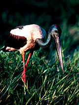
Birds
Kakadu’s many habitats support more than 280 species of birds, or about one-third of Australia’s bird species. Some birds range over a number of habitats, but many are found in only one environment.Some 11,246 km2 of Kakadu’s savanna
Savanna
A savanna, or savannah, is a grassland ecosystem characterized by the trees being sufficiently small or widely spaced so that the canopy does not close. The open canopy allows sufficient light to reach the ground to support an unbroken herbaceous layer consisting primarily of C4 grasses.Some...
habitats has been identified by BirdLife International
BirdLife International
BirdLife International is a global Partnership of conservation organisations that strives to conserve birds, their habitats and global biodiversity, working with people towards sustainability in the use of natural resources...
as an Important Bird Area
Important Bird Area
An Important Bird Area is an area recognized as being globally important habitat for the conservation of bird populations. Currently there are about 10,000 IBAs worldwide. The program was developed and sites are identified by BirdLife International...
(IBA) because it supports populations of the endangered Gouldian Finch
Gouldian Finch
The Gouldian Finch, Erythrura gouldiae , also known as the Lady Gouldian Finch, Gould's Finch or the Rainbow Finch, is a colorful passerine bird endemic to Australia. There is strong evidence of a continuing decline, even at the best-known site near Katherine in the Northern Territory...
, the vulnerable
Vulnerable species
On 30 January 2010, the IUCN Red List of Threatened Species identified 9694 Vulnerable species, subspecies and varieties, stocks and sub-populations.-References:...
Red Goshawk
Red Goshawk
The Red Goshawk is probably the rarest Australian bird of prey. It is found mainly in the savanna woodlands of northern Australia, particularly near watercourses...
, the near threatened
Near Threatened
Near Threatened is a conservation status assigned to species or lower taxa that may be considered threatened with extinction in the near future, although it does not currently qualify for the threatened status...
Partridge Pigeon
Partridge Pigeon
The Partridge Pigeon is a species of bird in the Columbidae family.It is endemic to Australia.Its natural habitats are subtropical or tropical dry shrubland and subtropical or tropical dry lowland grassland....
and Chestnut-backed Button-quail
Chestnut-backed Button-quail
The Chestnut-backed Buttonquail is a species of bird in the Turnicidae family.It is endemic to Australia.Its natural habitats are dry savanna, subtropical or tropical dry shrubland, and subtropical or tropical dry lowland grassland.-References:* BirdLife International 2004. . Downloaded on 24...
, and the restricted-range Hooded Parrot
Hooded Parrot
The Hooded Parrot, Psephotus dissimilis is a medium-sized, up to 26cm long, turquoise blue parrot with black head, green wing, brown back and greenish blue-bronze tail feathers edged with white. It has pale grey beak, greyish brown legs and brown eye...
and Rainbow Pitta
Rainbow Pitta
The Rainbow Pitta, Pitta iris, is a bird with a velvet black head and underparts, green upperparts, pale blue shoulder and olive green tail. It has a black bill, pink legs, brown eye and reddish brown streak along each side of its crown...
. The Kakadu Savanna IBA also supports Varied Lorikeet
Varied Lorikeet
The Varied Lorikeet is a species of parrot in the Psittacidae family.It is endemic to northern Australia.-Description:...
s, Northern Rosella
Northern Rosella
The Northern Rosella , also known as Brown's Parakeet or Smutty Rosella, is found in Australia's Top End. It is unusually coloured for a rosella, with a dark crown and white cheeks similar to its relatives the Pale-headed Rosella and the Eastern Rosella.At 28 cm long it is smaller than all bar...
s, Silver-crowned Friarbird
Silver-crowned Friarbird
The Silver-crowned Friarbird is a species of bird in the Meliphagidae family.It is endemic to Australia.Its natural habitats are subtropical or tropical dry forests and subtropical or tropical mangrove forests.-References:...
s, White-gaped
White-gaped Honeyeater
The White-gaped Honeyeater is a species of bird in the Meliphagidae family.It is endemic to Australia.Its natural habitats are subtropical or tropical moist lowland forests and subtropical or tropical mangrove forests....
, Yellow-tinted
Yellow-tinted Honeyeater
The Yellow-tinted Honeyeater is a species of bird in the Meliphagidae family.It is found in Australia and Papua New Guinea....
, White-lined
White-lined Honeyeater
The White-lined Honeyeater is a species of bird in the Meliphagidae family. It is endemic to northern Australia. Its natural habitat is subtropical or tropical moist lowland forests. It formerly included the Kimberley Honeyeater as a subspecies.-References:* BirdLife International 2004. . ...
, Bar-breasted
Bar-breasted Honeyeater
The Bar-breasted Honeyeater is a species of bird in the Meliphagidae family.It is endemic to Australia.-References:* BirdLife International 2004. . Downloaded on 27 July 2007....
and Banded Honeyeater
Banded Honeyeater
The Banded Honeyeater is a species of bird in the Meliphagidae family.It is endemic to Australia.Its natural habitats are subtropical or tropical dry forests, subtropical or tropical mangrove forests, and Mediterranean-type shrubby vegetation.-References:* BirdLife International 2004. . ...
s, Sandstone Shrike-thrush
Sandstone Shrike-thrush
The Sandstone Shrikethrush is a species of bird in the Colluricinclidae family.It is endemic to Australia.-References:* BirdLife International 2004. . Downloaded on 25 July 2007....
es, White-browed Robin
White-browed Robin
The White-browed Robin is a species of bird in the family Petroicidae. It is endemic to north-eastern Australia. Its natural habitats are forest, woodland and scrub, often near water...
s, Canary White-eyes, and Masked
Masked Finch
The Masked Finch is a small passerine bird in the estrildid finch family, Estrildidae. It is a common resident of dry savanna across northern Australia, from the Kimberley, across the Top End, the Gulf country and the southern part of Cape York Peninsula, as far east as Chillagoe, but always near...
and Long-tailed Finch
Long-tailed Finch
The Long-tailed Finch is a common species of estrildid finch found in Australia; also known as the Blackheart Finch, Shaft-tail Finch, Heck's Grassfinch, Heck's Grass Finch, and Heck's Finch. It is a predominantly fawn-coloured bird with a pale grey head and prominent black bib and eyes...
es.
Reptiles
Some 117 species of reptiles have been recorded in Kakadu. Being cold blooded, these animals rely on heat from an external source such as the sun to regulate their body temperature. This is not to say that reptiles are active only during the day; in fact, few snakes can withstand Kakadu’s midday heat and most are active at night. Since the arrival of the Cane Toad in the park, many populations of reptiles have crashed. Reptiles which were once a common sight such as large goannas, King Brown snakes, Death Adders and many others are now rare. The iconic Frill-necked Lizard has also significantly dropped in numbers.Two species of crocodile
Crocodile
A crocodile is any species belonging to the family Crocodylidae . The term can also be used more loosely to include all extant members of the order Crocodilia: i.e...
occur in Kakadu: the Freshwater Crocodile (Crocodylus johnstonii) and the Estuarine, or Saltwater Crocodile (C. porosus). Freshwater Crocodiles are easily identified by their narrow snout and a single row of four large boney lumps called ‘scutes’ immediately behind the head. Estuarine Crocodiles do not have these scutes and their snout is broader. The maximum size for a ‘freshie’ is 3 metres, whereas a ‘saltie’ can exceed 6 metres.
Frogs
Kakadu’s 25 frogFrog
Frogs are amphibians in the order Anura , formerly referred to as Salientia . Most frogs are characterized by a short body, webbed digits , protruding eyes and the absence of a tail...
species are extremely well adapted to the region’s climatic extremes. Many remain dormant during rainless times. With the onset of the wet season, when the billabong
Billabong
Billabong is an Australian English word meaning a small lake, specifically an oxbow lake, a section of still water adjacent to a river, cut off by a change in the watercourse. Billabongs are usually formed when the path of a creek or river changes, leaving the former branch with a dead end...
s and swamps start to fill with water, the night air is filled with the sounds of frogs such as the northern bullfrog and the marbled frog. As the water builds up, frogs and tadpoles have an abundance of food, such as algae, vegetation, insects, dragonfly nymphs, and other tadpoles. Not all of Kakadu’s frogs are found in the wetlands: many live in the lowland forests.
Fish
Fifty-three species of freshwater fishFreshwater fish
Freshwater fish are fish that spend some or all of their lives in freshwater, such as rivers and lakes, with a salinity of less than 0.05%. These environments differ from marine conditions in many ways, the most obvious being the difference in levels of salinity...
have been recorded in Kakadu’s waterways; eight of them have a restricted distribution. In the Magela Creek system alone, 32 species have been found. In comparison, the Murray–Darling river system, the most extensive in Australia, now supports only 27 native fish species. Although introduced fish have been found in most Australian waterways, none have been recorded in the Park.
Insects
Despite the fact that Kakadu supports more than 10,000 species of insect, these creatures are often overlooked by visitors. Among the insect groups are grasshopperGrasshopper
The grasshopper is an insect of the suborder Caelifera in the order Orthoptera. To distinguish it from bush crickets or katydids, it is sometimes referred to as the short-horned grasshopper...
s, beetles, flies, termite
Termite
Termites are a group of eusocial insects that, until recently, were classified at the taxonomic rank of order Isoptera , but are now accepted as the epifamily Termitoidae, of the cockroach order Blattodea...
s, butterflies
Butterfly
A butterfly is a mainly day-flying insect of the order Lepidoptera, which includes the butterflies and moths. Like other holometabolous insects, the butterfly's life cycle consists of four parts: egg, larva, pupa and adult. Most species are diurnal. Butterflies have large, often brightly coloured...
and moth
Moth
A moth is an insect closely related to the butterfly, both being of the order Lepidoptera. Moths form the majority of this order; there are thought to be 150,000 to 250,000 different species of moth , with thousands of species yet to be described...
s, bee
Bee
Bees are flying insects closely related to wasps and ants, and are known for their role in pollination and for producing honey and beeswax. Bees are a monophyletic lineage within the superfamily Apoidea, presently classified by the unranked taxon name Anthophila...
s, wasp
Wasp
The term wasp is typically defined as any insect of the order Hymenoptera and suborder Apocrita that is neither a bee nor an ant. Almost every pest insect species has at least one wasp species that preys upon it or parasitizes it, making wasps critically important in natural control of their...
s, ant
Ant
Ants are social insects of the family Formicidae and, along with the related wasps and bees, belong to the order Hymenoptera. Ants evolved from wasp-like ancestors in the mid-Cretaceous period between 110 and 130 million years ago and diversified after the rise of flowering plants. More than...
s, dragonflies
Dragonfly
A dragonfly is a winged insect belonging to the order Odonata, the suborder Epiprocta or, in the strict sense, the infraorder Anisoptera . It is characterized by large multifaceted eyes, two pairs of strong transparent wings, and an elongated body...
and damselflies
Damselfly
Damselflies are insects in the order Odonata. Damselflies are similar to dragonflies, but the adults can be distinguished by the fact that the wings of most damselflies are held along, and parallel to, the body when at rest...
, caddis flies, non-biting midges and mayflies
Mayfly
Mayflies are insects which belong to the Order Ephemeroptera . They have been placed into an ancient group of insects termed the Palaeoptera, which also contains dragonflies and damselflies...
. The great variety of insects is a result of the varied habitats and relatively high temperatures throughout the year.
Perhaps the most striking insect-created features in the Park are the termite mounds. The mounds in the southern part of the Park are particularly large and impressive. Leichhardt’s grasshopper, in colours of orange, blue and black, is perhaps the most spectacular insect found in Kakadu. It is also found on the Arnhem Land plateau and in Gregory National Park.
Environmental issues and threats
Kakadu has seen several invasive species threaten the native habitat, particularly in recent decades. Introduced fauna including the Water Buffalo, wild pig and more recently, the Cane ToadCane Toad
The Cane Toad , also known as the Giant Neotropical Toad or Marine Toad, is a large, terrestrial true toad which is native to Central and South America, but has been introduced to various islands throughout Oceania and the Caribbean...
have had major effects on habitat. Invasive weeds include Mimosa pigra
Mimosa pigra
Mimosa pigra , is an invasive species of the genus Mimosa, in the family Fabaceae. It is native to the Neotropics, but has been listed as one of the world's 100 worst invasive species, and has been documented in: Australia, Cambodia, Dominican Republic, Ghana, Guinea, Indonesia, Kenya, Malaysia,...
, which covers 800 km² of the Top End, including vast areas of Kakadu, invasive paragrass displaces the native food of much of Kakadu's birdlife. Salvinia molesta has infested the Magela floodplain. Brumbies
Brumby
A Brumby is a free-roaming feral horse in Australia. Although found in many areas around the country, the best-known brumbies are found in the Australian Alps region in south-eastern Australia. Today, most of them are found in the Northern Territory, with the second largest population in Queensland...
also inhabit areas of the National Park, including Yellow Water.
Landforms
There are six main landforms in Kakadu National Park: the Arnhem Land plateau and escarpment complex, known as the stone country; the outliers; the lowlands; the southern hills and basins; the floodplains; and the tidal flats. Each landform has its own range of habitats. Kakadu’s varied landscapes and the habitats they contain are features that contributed to its listing as a World Heritage Area.Most of Kakadu was under a shallow sea approximately 140 million years ago, with the escarpment wall formed from sea cliffs and Arnhem Land from a flat plateau above the sea. Currently the escarpment rises 330 metres above the plateau and extends approximately 500 kilometres along the East edge of the park and on into Arnhem Land. The escarpment varies from near vertical cliffs in the Jim Jim Falls
Jim Jim Falls
Jim Jim Falls is a 200 m high waterfall located in the Kakadu National Park, in the Northern Territory, Australia. It is believed that 140 million years ago much of Kakadu was under a shallow sea. The prominent escarpment wall formed sea cliffs and the Arnhem Land plateau formed a flat land...
area to isolated outliers and stepped cliffs in the North.
Chasms and gorges form a network that dissects the rocky platforms on the plateau. The plateau top is a harsh, dry environment where water drains away quickly and top soil is scarce in most areas. Sparse pockets of open forest and woodlands have developed in these areas. However creeks have carved deep gorges in the escarptment in which tall monsoon forests grow. These areas form microclimate
Microclimate
A microclimate is a local atmospheric zone where the climate differs from the surrounding area. The term may refer to areas as small as a few square feet or as large as many square miles...
s for plants and animals and often serve as a refuge during the dry season. Allosyncarpia
Allosyncarpia
Allosyncarpia is a genus of the botanical family Myrtaceae....
ternata, a large shady tree found only in the Kakadu and Arnhem Land, is the dominant plant species.
The outliers are essentially pieces of the Arnhem Land plateau that have become separated from the plateau complex by erosion. They were islands in the ancient seas that once covered much of Kakadu. The gently undulating lowland plains stretch over much of the Top End. Travelling anywhere in Kakadu, you cannot help noticing the lowlands—they make up nearly 70% of the Park. The soils are shallow and often overlie extensive sheets of laterite (ironstone) and a thick profile of strongly leached rocks.
During the wet season
Wet season
The the wet season, or rainy season, is the time of year, covering one or more months, when most of the average annual rainfall in a region occurs. The term green season is also sometimes used as a euphemism by tourist authorities. Areas with wet seasons are dispersed across portions of the...
, water carried down from the Arnhem Land plateau often overflows from creeks and rivers onto nearby floodplains. Alluvial soils carried in the floodwaters add nutrients to the floodplains. Nutrient-rich soils along with an abundance of water and sunlight make the floodplains an area of prolific plant and animal life. During the dry season the water recedes into rivers, creeks and isolated waterholes or billabong
Billabong
Billabong is an Australian English word meaning a small lake, specifically an oxbow lake, a section of still water adjacent to a river, cut off by a change in the watercourse. Billabongs are usually formed when the path of a creek or river changes, leaving the former branch with a dead end...
s. Kakadu’s wetlands are listed under the Convention on Wetlands of International Importance (the Ramsar Convention) for their outstanding ecological, botanical, zoological and hydrological features.
The southern hills and basins cover a large area in the south of the Park, including the headwaters of the South Alligator River. Rocks here have been exposed from beneath the retreating Arnhem escarpment; they are of volcanic origin and are extremely old (2500 million years). This landform is characterised by rugged strike ridges separated by alluvial flats.
The estuaries and tidal flats are home to an array of plants and animals adapted to living in the oxygen-deficient saline mud. The dominant habitats are mangrove swamps and samphire flats. Where freshwater springs occur along the coasts and river banks, isolated pockets of coastal monsoon rainforests form.
Aboriginal rock art sites
Ubirr
Ubirr is located in the East Alligator region of Kakadu National Park in the Northern Territory of Australia, and is famous for its rock art. It consists of a group of rock outcrops on the edge of the Nadab floodplain where there are several natural shelters that have a collection of Aboriginal...
, Burrunguy (Nourlangie Rock) and Nanguluwu
Nanguluwu
Nanguluwur or Nanguluwu is a small art site in the Kakadu National Park, near Nourlangie Rock, which is reached via the Gubara road then a 1.7km walking track...
r are internationally recognised as outstanding examples of Aboriginal rock art. These sites are found in rocky outcrops that have afforded shelter to Aboriginal inhabitants for thousands of years. The painting in these rock shelters were done for various reasons:
- Hunting - animals were often painted to increase their abundance and to ensure a successful hunt by placing people in touch with the spirit of the animal
- Religious significance - at some sites paintings depict aspects of particular ceremonies
- Stories and learning - stories associated with the Creation Ancestors, who gave shape to the world were painted
- Sorcery and magic - paintings could be used to manipulate events and influence people's lives; fun-for play and practice.
Barramundi
The Barramundi , also known as Asian Seabass, is a species of catadromous fish in family Latidae of order Perciformes. The native species is widely distributed in the Indo-West Pacific region from the Persian Gulf, through Southeast Asia to Papua New Guinea and Northern Australia. Known in Thai...
, catfish
Catfish
Catfishes are a diverse group of ray-finned fish. Named for their prominent barbels, which resemble a cat's whiskers, catfish range in size and behavior from the heaviest and longest, the Mekong giant catfish from Southeast Asia and the second longest, the wels catfish of Eurasia, to detritivores...
, mullet
Mullet (fish)
The mullets or grey mullets are a family and order of ray-finned fish found worldwide in coastal temperate and tropical waters, and in some species in fresh water. Mullets have served as an important source of food in Mediterranean Europe since Roman times...
, goanna
Goanna
Goanna is the name used to refer to any number of Australian monitor lizards of the genus Varanus, as well as to certain species from Southeast Asia.There are around 30 species of goanna, 25 of which are found in Australia...
, snake-necked turtle
Chelodina
This large and diverse genus of long-necked Chelid turtles has had a complicated nomenclatural history. Although in the past the following have been considered separate genera and prior to that all the same, they are now considered sub-genera of the one genus....
, pig-nosed turtle, Rock-haunting Ringtail Possum
Rock-haunting Ringtail Possum
The Rock-haunting Ringtail Possum , also known as the Rock Ringtail Possum, is a species of Australian possum. It is found in rocky escarpments in the Kimberley, Arnhem Land and Gulf of Carpentaria across Western Australia and Northern Territory and just passing the Queensland border. It is also...
, and wallaby
Wallaby
A wallaby is any of about thirty species of macropod . It is an informal designation generally used for any macropod that is smaller than a kangaroo or wallaroo that has not been given some other name.-Overview:...
and thylacine
Thylacine
The thylacine or ,also ;binomial name: Thylacinus cynocephalus, Greek for "dog-headed pouched one") was the largest known carnivorous marsupial of modern times. It is commonly known as the Tasmanian tiger or the Tasmanian wolf...
(Tasmanian Tiger).
There are also images of the Rainbow Serpent said to have created much of the landscape as well as mischievous Mimi spirits and the story of the Namarrgarn Sisters. Many stories connected to Aboriginal rock are highly complex and linked to other stories. Often the true meanings have been lost, but they all have a purpose which is usually to serve as a lesson or a warning to the young or to those passing through the area.
Burrunguy, formally called Nourlangie Rock, is located in an outlying formation of the Arnhem Land Escarpment. There are a number of shelters in amongst this large outcrop linked by paths and stairways. The shelters contain several impressive paintings that deal with creation ancestors. Some of the stories connected to these artworks are known only to certain Aboriginal people and remain secret.
Anbangbang Billabong
Anbangbang Billabong
Anbangbang Billabong lies in the shadow of Nourlangie Rock within Kakadu National Park and is a good place to view a wide range of wildlife. Large numbers of water fowl and wading birds inhabit the billabong and many wallabies can be found grazing around the water’s edge...
lies in the shadow of Nourlangie Rock and is inhabited by a wide range of wildlife which would have sustained traditional Aboriginal people well.
Nanguluwur is a small art site, near Nourlangie, which displays several rock art styles. These include hand stencils, dynamic figures in large head-dresses carrying spears and boomerangs, representations of Namandi spirits and mythical figures, including Alkajko, a female spirit with four arms and horn-like protuberances. There is also an interesting example of ‘contact art’ depicting a two-masted sailing ship with anchor chain and a dinghy trailing behind.
Human impacts
Human impacts during the 19th and 20th century have been significant. Introduction of Domestic Asian Water Buffalo from Southeast AsiaAsia
Asia is the world's largest and most populous continent, located primarily in the eastern and northern hemispheres. It covers 8.7% of the Earth's total surface area and with approximately 3.879 billion people, it hosts 60% of the world's current human population...
has resulted in damage to the fragile floodplains and wetlands. Since then, buffalo have largely been eradicated from the area so the land is now rehabilitating itself. Crocodile hunting which has been banned since 1972 made a huge impact on crocodile populations. In the 30 or so years that they have been protected, however the crocodile population has recovered so successfully that some consider there to be an over population.
Mining has an obvious impact on the landscape, but only one operational uranium mine (Ranger
Ranger Uranium Mine
The Ranger uranium mine is surrounded by Kakadu National Park, in the Northern Territory of Australia, 230 km east of Darwin. The orebody was discovered in 1969, and the mine commenced operation in 1980, reaching full production of uranium oxide in 1981...
) remains. Mine operators are required to completely rehabilitate the area once the operation is wound down. Some small scale logging occurred in the early part of the 20th century, but little evidence of this remains. Tourism represents a significant human impact to Kakadu National Park with hundreds of thousands of visitors arriving annually. Infrastructure such as roads, tracks, interpretive signage and shelter, accommodation, telecommunications and other services must be provided to support this activity.
Fire management
Fire is part of the landscape of Kakadu National Park as the Park contains large areas of woodland and grassy plains that are subject to long periods of dry hot weather. The flora of the region has adapted to frequent fires. Fires in northern Australia are less threatening than in southern Australia as many of the trees are largely fire resistant while other plants simply regenerate very quickly.Controlled burning is practiced by the national park in consultation with traditional owners who have used fire as a land management tool for thousands of years. Fire is an important hunting tool for Aboriginal people using it to flush out prey. The other benefit is that once the fire has gone through an area the tender shoots of the fast regenerating grasses attract wallabies into a clearly defined area. Birds of prey such as Whistling Kites also rely on fire to flush out small animals and are usually found in large numbers circling a fire front. Other species such as white-throated grasswrens have declined because of too many fires. Aboriginal people understand that fire is necessary to ‘clean up’ the landscape and believe that many small fires are preferable to one large fire.
Tourism
Kakadu National Park is a major tourist attraction in Australia’s north. Visitation in 2005 was 202,000. Kakadu’s dramatic landscape, Aboriginal cultural significance and diverse and abundant wildlife are what visitors are drawn to. There are many beautiful waterfallWaterfall
A waterfall is a place where flowing water rapidly drops in elevation as it flows over a steep region or a cliff.-Formation:Waterfalls are commonly formed when a river is young. At these times the channel is often narrow and deep. When the river courses over resistant bedrock, erosion happens...
s and gorges within the Park that are popular with visitors such as Maguk
Maguk
Maguk is located in the south of Kakadu National Park in the Northern Territory, Australia.Maguk is one of the only waterfalls in Kakadu that flows while there is no rain. Towards the end of the dry season however, the flow is much weaker than in the peak of the wet season.-External links:*...
, Gunlom, Twin Falls
Twin Falls, Australia
Twin Falls is located in the Kakadu National Park in the Northern Territory, Australia. It is located near the eastern boundary of the park and 80 km south of Jabiru. It is also known as Gungkurdul...
and Jim Jim Falls
Jim Jim Falls
Jim Jim Falls is a 200 m high waterfall located in the Kakadu National Park, in the Northern Territory, Australia. It is believed that 140 million years ago much of Kakadu was under a shallow sea. The prominent escarpment wall formed sea cliffs and the Arnhem Land plateau formed a flat land...
.
Kakadu National Park has some of the best examples of Aboriginal rock art in Australia. The sites of Nourlangie and Ubirr are among the most visited locations in the Park. It is possible to view some of Kakadu’s diverse wildlife at places like Yellow Water Billabong, Cooinda on board a wildlife cruise or at Mamukala Wetlands or Anbangbang Billabong. The Kakadu region is one of the world’s best for bird watching as approximately 30 percent of Australia’s bird species can be seen here.
Saltwater Crocodile
The saltwater crocodile, also known as estuarine or Indo-Pacific crocodile, is the largest of all living reptiles...
s are also commonplace and visitors are likely to see them at Yellow Water and East Alligator River so it was no coincidence that the Crocodile Dundee films were shot here. Visitors are urged to exercise caution around crocodiles as they have been responsible for a number of fatal attacks. Recreational fishing is a popular activity inside Kakadu National Park. The main target species is Barramundi and the most popular locations are Yellow Water, the South Alligator and the East Alligator River. Hunting is not allowed in Kakadu National Park.
There are several accommodation options in the Park, mostly found in the town of Jabiru, as well as a range of services to cater to visitor’s needs. Visitors can experience Kakadu National Park with a recognised tour operator or they can drive themselves. Many of the Park’s sites are accessible by standard two wheel drive vehicles, but areas like Twin and Jim Jim Falls and Gunlom require four wheel drive vehicles. Visitors can experience Kakadu National Park via the Nature’s Way tourism drive which is a loop from Darwin to Jabiru then onto Katherine
Katherine, Northern Territory
Katherine is a town situated southeast of Darwin in the "Top End" of Australia in the Northern Territory. It is the fourth largest settlement in the Territory after the capital Darwin, Palmerston and Alice Springs...
and back to Darwin covering approximately 900km.
Park management
The Park is proclaimed under the Environment Protection and Biodiversity Conservation Act 1999 (the EPBC Act) and is managed through a joint management arrangement between the Aboriginal traditional owners and the Director of National Parks. The Director manages Commonwealth national parks through Parks Australia, which is a part of the Department of Sustainability, Environment, Water, Population and Communities. Title to Aboriginal land in the Park is held by Aboriginal land trusts. The land trusts have leased their land to the Director of National Parks for the purpose of a national park for the enjoyment and benefit of all Australians and international visitors. Traditional owners have also expected that having their land managed as a national park would assist them in looking after their land in the face of growing and competing pressures. They saw a national park as establishing a way to manage the land that could protect their interests and be sympathetic to their aspirations. Parks Australia and the Aboriginal traditional owners of Kakadu are committed to the principle of joint management of the Park and arrangements to help this happen are highlighted in Kakadu’s Plan of Management.Day to day management of Kakadu is carried out by people employed by Parks Australia, which is a branch of the Australian Government’s Department of Sustainability, Environment, Water, Population and Communities. Approximately one-third of the staff in Kakadu are Aboriginal people.
Park use fee
Kakadu National Park re-introduced a park use fee from April 2010, to help manage the natural and cultural values of the park environment and improve visitor services.Like many World Heritage sites around the world, including Yellowstone National Park, Serengeti National Park, Stonehenge, Pompeii and Herculaneum and the Pyramids of Egypt - the park use fee helps to maintain world-best management practices and facilities for the more than 200,000 visitors who experience Kakadu each year.
The $25 fee (which is inclusive of GST) applies to all interstate and international visitors aged 16 years and over. All Northern Territory residents and children under 16 are exempt.
Tickets and more information will be available on the Kakadu National Park tourism website.
General facilities
Kakadu National Park is linked to Darwin by the Arnhem Highway and to Pine CreekPine Creek, Northern Territory
Pine Creek is a small town in the Katherine region of the Northern Territory, Australia. According to the 2001 Australian census 665 people live in Pine Creek, which is the fourth largest town between Darwin and Alice Springs....
and Katherine by the Kakadu Highway. Both roads are sealed all weather roads although may be cut off periodically during periods of heavy rain.
The town of Jabiru has several accommodation options, a service station, police, a medical clinic and a shopping centre with a range of outlets. The town was built for the Uranium mine that was established prior to the founding of Kakadu National Park and provides infrastructure for the mine’s workforce as well as the national park activities and tourism. Jabiru has a small airport from which scenic flights operate daily. There are no scheduled air services between Jabiru and Darwin however.
Other small tourism centres such as Cooinda and South Alligator provide limited facilities. Cooinda, 50km south of Jabiru on the Kakadu Highway is the site of Gagudju Lodge Cooinda, Yellow Water Cruises and the Warradjan Cultural Centre. Fuel and limited provisions are available at Cooinda and there is also a small airstrip for scenic flights. South Alligator approximately 40km west of Jabiru on the Arnhem Highway includes a hotel and service station. The Border Store near Ubirr Art Site and Cahills Crossing, 50km north of Jabiru, is a general store.
Camp sites
There are a wide variety of designated camping sites throughout the Park. Jabiru, Cooinda and South Alligator all have commercial camping areas and are in close proximity to most of the important natural attractions in these areas. Some of the Park’s campsites charge a nominal fee as these have shower and toilet facilities, others are free, however they have limited or no facilities. A list of the sites can be obtained from the Kakadu National Park’s Glenn MurcuttGlenn Murcutt
Glenn Marcus Murcutt AO is a British-born Australian architect and winner of the 2002 Pritzker Prize and 2009 AIA Gold Medal.-Biography:...
-designed Bowali Visitor Centre or from their website.
External links
- World heritage listing for Kakadu National Park
- Kakadu National Park website
- Kakadu National Park tourism website
- An Easy Adventure travel story by Roderick Eime
- Kakadu or Don't Is Kakadu Losing Its Way?
- Aboriginal Tradition Local Bininj people interpret 6 different seasons in Kakadu
- Google Map Map of Kakadu National Park with major camp sites
- Bird Watching Google Map Map of Kakadu National Park with major bird watching spots