

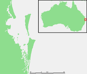
Moreton Bay
Encyclopedia
Australia
Australia , officially the Commonwealth of Australia, is a country in the Southern Hemisphere comprising the mainland of the Australian continent, the island of Tasmania, and numerous smaller islands in the Indian and Pacific Oceans. It is the world's sixth-largest country by total area...
45 km from Brisbane
Brisbane
Brisbane is the capital and most populous city in the Australian state of Queensland and the third most populous city in Australia. Brisbane's metropolitan area has a population of over 2 million, and the South East Queensland urban conurbation, centred around Brisbane, encompasses a population of...
, Queensland
Queensland
Queensland is a state of Australia, occupying the north-eastern section of the mainland continent. It is bordered by the Northern Territory, South Australia and New South Wales to the west, south-west and south respectively. To the east, Queensland is bordered by the Coral Sea and Pacific Ocean...
. It is one of Queensland's most important coastal resources. The waters of Moreton Bay are a popular destination for recreational anglers and are used by commercial operators who provide seafood to market.
The Port of Brisbane
Port of Brisbane
Port of Brisbane is the shipping port of Brisbane, on the east coast of Australia. It is located in the lower reaches of the Brisbane River on reclaimed land that was once called Fisherman Islands at the mouth of the river. It currently is the third busiest port in Australia and the nation's...
coordinates large traffic along the shipping channel
Channel (geography)
In physical geography, a channel is the physical confine of a river, slough or ocean strait consisting of a bed and banks.A channel is also the natural or human-made deeper course through a reef, sand bar, bay, or any shallow body of water...
which crosses the northern section of the bay. The bay serves as a safe approach to the airport and reduces noise pollution
Noise pollution
Noise pollution is excessive, displeasing human, animal or machine-created environmental noise that disrupts the activity or balance of human or animal life...
over the city to the west of the runway. A number of barge, ferry and water-taxi services also travel over the bay.
Moreton Bay was the site of conflict between indigenous Australians
Australian Aborigines
Australian Aborigines , also called Aboriginal Australians, from the latin ab originem , are people who are indigenous to most of the Australian continentthat is, to mainland Australia and the island of Tasmania...
and early European settlers. It contains environmentally significant habitats and large areas of sandbanks. The bay is the only place in Australia where dugong
Dugong
The dugong is a large marine mammal which, together with the manatees, is one of four living species of the order Sirenia. It is the only living representative of the once-diverse family Dugongidae; its closest modern relative, Steller's sea cow , was hunted to extinction in the 18th century...
gather into herds. Many parts of the mainland foreshore and southern islands are settled.
Moreton Bay is described as lagoon
Lagoon
A lagoon is a body of shallow sea water or brackish water separated from the sea by some form of barrier. The EU's habitat directive defines lagoons as "expanses of shallow coastal salt water, of varying salinity or water volume, wholly or partially separated from the sea by sand banks or shingle,...
al because of the existence of a series of off-shore barrier island
Barrier island
Barrier islands, a coastal landform and a type of barrier system, are relatively narrow strips of sand that parallel the mainland coast. They usually occur in chains, consisting of anything from a few islands to more than a dozen...
s that restrict the flow of oceanic water. The tidal range
Tidal range
The tidal range is the vertical difference between the high tide and the succeeding low tide. Tides are the rise and fall of sea levels caused by the combined effects of the gravitational forces exerted by the Moon and the Sun and the rotation of the Earth...
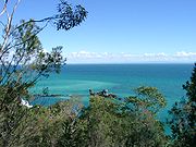
is moderate at 1.5–2 m in range. Moreton Bay has an average depth of 6.8 m. This shallow depth lets light filter through to the seafloor, allowing an array of marine plants to grow which support a diverse range of fauna. The bay itself covers 1,523 km² and has a catchment area 14 times larger, covering 21,220 km². The waters of the bay are mostly blue in colour. Western parts of the bay are sometimes tinted green from algae, brown from suspended sediment
Sediment
Sediment is naturally occurring material that is broken down by processes of weathering and erosion, and is subsequently transported by the action of fluids such as wind, water, or ice, and/or by the force of gravity acting on the particle itself....
s or yellow-brown from humic runoff.
History
Moreton Bay was formed roughly 6000 years ago as the sea level rose and inundated what was then the floodplains of the Brisbane RiverBrisbane River
The Brisbane River is the longest river in south east Queensland, Australia, and flows through the city of Brisbane, before emptying into Moreton Bay. John Oxley was the first European to explore the river who named it after the Governor of New South Wales, Thomas Brisbane in 1823...
.
Moreton Bay (Aboriginal name - Quandamooka) and its islands were inhabited by Aboriginal tribes. The name Morton's Bay was given by Captain Cook when he passed the area on 15 May 1770, honouring Lord Morton
James Douglas, 14th Earl of Morton
James Douglas, 14th Earl of Morton KT FRS was a Scottish astronomer and representative peer who was President of the Philosophical Society of Edinburgh from its foundation in 1737 until his death...
, president of the Royal Society
Royal Society
The Royal Society of London for Improving Natural Knowledge, known simply as the Royal Society, is a learned society for science, and is possibly the oldest such society in existence. Founded in November 1660, it was granted a Royal Charter by King Charles II as the "Royal Society of London"...
. The spelling Moreton was an error in the first published account of Cook's voyage (Hawkesworth's Voyages). Cook gave the name only to the bight
Bight (geography)
In geography, bight has two meanings. A bight can be simply a bend or curve in any geographical feature—usually a bend or curve in the line between land and water....
formed by the northern end of Stradbroke Island (in 1770, there was only one island) and the eastern side of Moreton Island. He was unaware of the South Passage
South Passage (Queensland)
South Passage is channel between the South Pacific Ocean and Moreton Bay. The other entrances to the bay are the North Passage and Jumpinpin Channel in the south.It was once the main entrance for ships entering the bay...
(as it's now called) between the two islands, and did not sail into what is the present Moreton Bay.
Matthew Flinders
Captain Matthew Flinders RN was one of the most successful navigators and cartographers of his age. In a career that spanned just over twenty years, he sailed with Captain William Bligh, circumnavigated Australia and encouraged the use of that name for the continent, which had previously been...
was the first recorded European to enter the Bay in 1799 touching down at the Pumicestone Passage, Redcliffe and Coochiemudlo Island. He was followed by John Oxley
John Oxley
John Joseph William Molesworth Oxley was an explorer and surveyor of Australia in the early period of English colonisation.October 1802 he was engaged in coastal survey work including an expedition to Western Port in 1804-05...
who explored the Brisbane River in 1823. On a subsequent visit in the following year, Oxley established the first European settlement in the Bay at the present site of Redcliffe.
After Oxley in 1823 came convicts and soldiers. As the South Passage between Moreton and Stradbroke Islands was the shortest shipping route
Shipping route
A shipping route is a trade route used by merchant ships.Early routes usually were coastal in nature as navigators had to rely on the coastal landmarks...
, a depot and pilot station were established at Amity Point in 1825.
European settlement began in earnest after the abandonment of the Redcliffe settlement, and work began on the new convict settlement
Penal colony
A penal colony is a settlement used to exile prisoners and separate them from the general populace by placing them in a remote location, often an island or distant colonial territory...
several miles up the Brisbane River in 1825. Within a couple years this new settlement was growing rapidly and the number of ships entering the bay was increasing. As a result, the facilities required to service the pilot station at Amity grew, and in 1827 convicts were sent to the island to build a new causeway at Dunwich, remnants of which can still be found on the same site. Within a year the first permanent European settlement at Dunwich had been built. Due to poor weather, smuggling, and conflict with aborigines this convict out-station was difficult to sustain and was closed in 1831.
Artemisia (ship)
The Artemisia Almost all sources spell the name Artemisia; however, the spelling Artemesia has been used in at least one source: Ronald Wood "Artemesia: the first migrant ship to Moreton Bay", Journal of the Royal Historical Society of Queensland, Vol. 14 no. 5, pp 181-183...
, reached Moreton Bay in December 1848 after a four month journey. The next year saw the arrival of the Fortitude
Fortitude (ship)
Fortitude was a sailing ship. In 1848-9, she carried free immigrants to Brisbane, Australia.Captained by John Christmas, she departed Gravesend on 14 September 1848, arriving Moreton Bay on 21 January 1849. Fortitude Valley is named in her honor....
carrying more free immigrants to the settlement.
By the 1850s the regions earliest industry was utilising the bay for the transport of timber
Timber
Timber may refer to:* Timber, a term common in the United Kingdom and Australia for wood materials * Timber, Oregon, an unincorporated community in the U.S...
. After felling the logs were dragged or rolled into flooded streams from where they were washed downstream to tidal reaches and bound together into rafts. After the floods had ceased and tides returned to normal, the currents
Ocean current
An ocean current is a continuous, directed movement of ocean water generated by the forces acting upon this mean flow, such as breaking waves, wind, Coriolis effect, cabbeling, temperature and salinity differences and tides caused by the gravitational pull of the Moon and the Sun...
of the bay and sometimes boats were used to direct the timber north to the Brisbane River or to Dunwich for shipment to Sydney.
The bay was home to the Lightship Rose which provided a permanent navigation aid to passing ships at the mouth of the Brisbane River. The John Oxley
John Oxley (ship)
SS John Oxley is a former pilot boat and lighthouse and buoy tender in Australia. She belongs to the Lady Hopetoun and Port Jackson Marine Steam Museum Ltd. and is currently undergoing restoration at Rozelle Bay, Sydney. John Oxley is the last surviving inshore steamer in Australia and is...
was another notable boat which temporarily acted as a pilot ship.
Car ferries began crossing the bay to reach North Stradbroke Island in 1947, leading to an increase in tourism on the island. In the 1950s both sand mining and the first land sales at Point Lookout occurred.
European contact with Aborigines
At first the Quandamooka tribes had a choice of avoiding contact or engaging with the Europeans at the various small government institutions that were established on the mainland and on Minjerribah (Stradbroke IslandStradbroke Island
Stradbroke Island, also known as Minjerribah, was a large sand island that formed much of the eastern side of Moreton Bay near Brisbane, Queensland until the late 19th century...
). Aboriginal labour and resources were however, voluntarily supplied to assist these newcomers, for example, at the pilot station. Problems came about when the newcomers displayed a lack of respect for Aboriginal marriage rules, stole bones and other artefacts and desecrated sites important to the Aboriginals. This produced a period of conflict through the 1830s, sometimes followed up by reprisals with guns, during which a number of Aboriginal people were massacred.
Like the mainland tribes, the Nooghie, Noonuccal and Goenpul people struggled when Moreton Bay was opened up to free settlers. The mainland Aboriginal people in particular were progressively deprived of the traditional hunting
Hunting
Hunting is the practice of pursuing any living thing, usually wildlife, for food, recreation, or trade. In present-day use, the term refers to lawful hunting, as distinguished from poaching, which is the killing, trapping or capture of the hunted species contrary to applicable law...
grounds and food. When they turned to killing domestic stock in order to survive, they were rounded up and shot. As their tribal groups and way of life disintegrated, many drifted towards towns and cities. Because of their isolation, the people of the islands however, managed to keep a lot of their traditional ways alive.
In 1843, Catholic Missionaries
Missionary
A missionary is a member of a religious group sent into an area to do evangelism or ministries of service, such as education, literacy, social justice, health care and economic development. The word "mission" originates from 1598 when the Jesuits sent members abroad, derived from the Latin...
chose Dunwich as the site for the first Catholic Mission to Australian Aborigines. The sand islands of Quandamooka did not support pasturage suitable for sheep and cattle, and thus there did not occur conversion of large tracts of land into farms and pastoral properties and the subsequent widespread annihilation and displacement of Aboriginal people. The very existence of the quarantine
Quarantine
Quarantine is compulsory isolation, typically to contain the spread of something considered dangerous, often but not always disease. The word comes from the Italian quarantena, meaning forty-day period....
station on Stradbroke Island from 1850 to the 1870s led to the official discouragement of pastoralism
Pastoralism
Pastoralism or pastoral farming is the branch of agriculture concerned with the raising of livestock. It is animal husbandry: the care, tending and use of animals such as camels, goats, cattle, yaks, llamas, and sheep. It may have a mobile aspect, moving the herds in search of fresh pasture and...
or wider settlement for fear of spreading disease. Another reason for discouraging settlement was to reduce the likelihood of incoming vessels to the bay evading customs duty.
Free enterprise
-Transport:* Free Enterprise I, a ferry in service with European Ferries between 1962 and 1980.* Free Enterprise II, a ferry in service with European Ferries between 1965 and 1982....
business men like the Campbell brothers who ran a saltworks and sugar plantation
Plantation
A plantation is a long artificially established forest, farm or estate, where crops are grown for sale, often in distant markets rather than for local on-site consumption...
s on Russell and Macleay islands, and the early fishing and oystering businesses in the bay who employed the Aboriginal people of Quandamooka.
Aboriginal peoples
Indigenous peoples
Indigenous peoples are ethnic groups that are defined as indigenous according to one of the various definitions of the term, there is no universally accepted definition but most of which carry connotations of being the "original inhabitants" of a territory....
were a source of labour for various institutions and enterprises from the time of the first pilot station. Conflict with Europeans intensified during the middle part of the 19th century, leading to significant numbers of Aboriginal people being killed (including at the hands of the native police). Despite these conflicts other Aboriginal people were able to evade intense contact due to the lack of European activity on the bay islands. From the 1830s to 1865 there remained virtual exclusive Aboriginal possession of most of Quandamooka. However trade and social interaction with the mainland groups gradually diminished due to the outward march of pastoral settlement on the mainland. This resulted in unrepairable damage to indigenous social network
Social network
A social network is a social structure made up of individuals called "nodes", which are tied by one or more specific types of interdependency, such as friendship, kinship, common interest, financial exchange, dislike, sexual relationships, or relationships of beliefs, knowledge or prestige.Social...
s and patterns of group intermarriage, as well as joint ceremonial activities.
Recent
On 1 September 2007 four people were killed in a boat accident on the bay, two kilometres from the Pinkenba boat ramp. Ten others were injured.The bay's marine park
Marine park
A marine park is a park consisting of an area of sea sometimes protected for recreational use, but more often set aside to preserve a specific habitat and ensure the ecosystem is sustained for the organisms that exist there...
zoning plan was renewed in 2008. Despite angst from both commercial and recreational fishers, draft Queensland Government
Government of Queensland
The Government of Queensland is commonly known as the "Queensland Government".The form of the Government of Queensland is prescribed in its Constitution, which dates from 1859, although it has been amended many times since then...
plans indicate further fishing restrictions aiming to protect more than 15 % of important marine and coastal environments. Artificial reef
Artificial reef
An artificial reef is a human-made underwater structure, typically built to promote marine life in areas with a generally featureless bottom, control erosion, block ship passage, or improve surfing....
s could be placed in Moreton Bay to ease the concerns of fishermen who fear they are being forced out. The State Government will spend $1 million on research, planning and construction of a new concrete reef in the bay.
An oil spill
2009 southeast Queensland oil spill
The 2009 southeast Queensland oil spill occurred on 11 March 2009 off the coast of southeast Queensland, Australia, in which 230 tonnes of fuel oil, 30 tonnes of other fuel and 31 shipping containers of ammonium nitrate spilled into the Coral Sea, north of Moreton Bay during Cyclone Hamish after...
occurred in March 2009 from the MV Pacific Adventurer
MV Pacific Adventurer
Pacific Mariner formerly, MV Pacific Adventurer is a 1123 TEU geared multi-purpose container ship that gained notoriety after causing Queensland's largest oil spill on the east coast of Australia in March 2009. The ship is owned by Swire Shipping and registered in Hong Kong...
dumping 100 tonnes of oil, 30 tonnes of fuel and other toxic chemicals on Brisbane's suburban beaches. Premier Anna Bligh
Anna Bligh
Anna Maria Bligh is an Australian politician and the Premier of Queensland since 2007. The 2009 Queensland state election was the first time a female-led political party won or retained state or federal government in Australia...
described the spill as "worst environmental disaster Queensland has ever seen".
Fresh concerns over the health of the bay and its water quality were raised in October 2009 after whales and a large number of the endangered Loggerhead Sea Turtle
Loggerhead Sea Turtle
The loggerhead sea turtle , or loggerhead, is an oceanic turtle distributed throughout the world. It is a marine reptile, belonging to the family Cheloniidae. The average loggerhead measures around long when fully grown, although larger specimens of up to have been discovered...
were found to be dying in the bay. In the same month a report was released indicating the overall quality of the bay's water had declined significantly, despite hundreds of millions of dollars spent on better sewage treatment and implementing run-off controls. Ten out of eighteen estuaries
Estuary
An estuary is a partly enclosed coastal body of water with one or more rivers or streams flowing into it, and with a free connection to the open sea....
that were monitored had a decline in quality. Blame was placed on heavy rains that washed sediment and nutrients into the bay after a drought.
After the 2011 Brisbane River floods washed contaminated water into the bay commercial fishermen and recreation anglers were warned not catch or eat seafood from its waters. The flood plume
Plume (hydrodynamics)
In hydrodynamics, a plume is a column of one fluid or gas moving through another. Several effects control the motion of the fluid, including momentum, diffusion, and buoyancy...
was investigated to monitor its impact on the bay's marine ecosystems. It contained sewerage, pesticides, heavy metals such as lead and zinc as well as hydrocarbons.
Through the use of underwater cameras and sensors, the Royal Australian Navy minehunter was used to locate sunken debris , particularly in shipping channels. The CSIRO used a robotic underwater glider to make sub-surface measurements. Together with satellite images and other data researchers will assess the effects of an extreme flood event on the waters of Moreton Bay. Sediment surveys revealed that most of the bay had cleared and that fishing could resume by 9 February.
Geography
Surfers Paradise, Queensland
Surfers Paradise is a suburb on the Gold Coast in Queensland, Australia. At the 2006 Census, Surfers Paradise had a population of 18,501....
in the south. The bay's southern navigation entrance is the Gold Coast Seaway
Gold Coast Seaway
The Gold Coast Seaway or Southport Seaway is the main navigation entrance from the Pacific Ocean into the Gold Coast Broadwater and southern Moreton Bay and is one of Australia’s most significant coastal engineering projects...
. The bay is 35 km across at its widest point.
It is separated from the Pacific Ocean
Pacific Ocean
The Pacific Ocean is the largest of the Earth's oceanic divisions. It extends from the Arctic in the north to the Southern Ocean in the south, bounded by Asia and Australia in the west, and the Americas in the east.At 165.2 million square kilometres in area, this largest division of the World...
by a chain of three sand island
Sand island
A sand island is an island that is largely or completely made of sand. The largest sand island in the world is Fraser Island. Other examples of large sand islands are Moreton and North Stradbroke Islands which lie south of Fraser Island off the east coast of Australia....
s - Moreton Island
Moreton Island
Moreton Island is a large sand island on the eastern side of Moreton Bay, on the coast of south-east Queensland, Australia. Moreton Island lies 58 kilometres northeast of the Queensland capital, Brisbane. The island is 95% National Park and a popular destination for four wheel driving, camping,...
in the north, North Stradbroke Island
North Stradbroke Island
North Stradbroke Island is an Australian island in the state of Queensland, 30 km southeast of the capital Brisbane. Before 1896 the island was part of the Stradbroke Island. In that year a storm separated it from South Stradbroke Island, forming the Jumpinpin Channel. It is known...
, and South Stradbroke Island
South Stradbroke Island
South Stradbroke Island is an Australian island in the state of Queensland, south of Brisbane and forms the northern end of Gold Coast. The 21 km by 2.5 km sized island is the smaller one of the two Stradbroke Islands and lies very close to the mainland. The island has hundreds of wild...
in the south. Tipplers Passage is the main channel on the western coast of South Stradbroke Island. The Gold Coast Seaway
Gold Coast Seaway
The Gold Coast Seaway or Southport Seaway is the main navigation entrance from the Pacific Ocean into the Gold Coast Broadwater and southern Moreton Bay and is one of Australia’s most significant coastal engineering projects...
is at the southern extent of Moreton Bay, before the Gold Coast Broadwater
Gold Coast Broadwater
The Gold Coast Broadwater, also known as Southport Broadwater and Gold Coast Harbour, is a large shallow estuary of water reaching from the locality of Southport to the southern section of the World Heritage Listed Moreton Bay along the eastern coast of Australia...
.
The bay itself contains around 360 islands in total. This includes the populated Russell, Macleay
Macleay Island
Macleay Island is an island located in Moreton Bay, South East Queensland. It is in the Redland City Council Local Government Area and has the postcode 4184. Perulpa Island is a small attached to Macleay Island by a causeway....
, Lamb and Karragarra Islands collectively known as the Southern Moreton Bay Islands. Residential development has also occurred on Coochiemudlo Island and Bribie Island. In the past Peel Island
Peel Island
Peel Island is a small island located in Moreton Bay, east of Brisbane, Queensland, in Australia.During the mid-19th century Peel Island was used as a quarantine station for the colony of Brisbane. Sailing ships would anchor to the north of the Island, the passengers would disembark on Peel Island...
has been used as a sisal plantation, quarantine station, asylum and a leper colony.
Moreton Bay is generally shallow and sandy, though a substantive channel is maintained to allow access to the Port of Brisbane
Port of Brisbane
Port of Brisbane is the shipping port of Brisbane, on the east coast of Australia. It is located in the lower reaches of the Brisbane River on reclaimed land that was once called Fisherman Islands at the mouth of the river. It currently is the third busiest port in Australia and the nation's...
at Fisherman Islands at the mouth of the Brisbane River, for international shipping. As well as the Brisbane River, the Pimpama River
Pimpama River
The Pimpama River is a river situated in South East Queensland, with its catchment located in the northern part of Gold Coast City. It is bounded by the Logan/Albert River catchment to the north, the Coomera River catchment to the south and the Broadwater in the east...
, Logan River, Albert River
Albert River (Queensland)
The Albert River is a river in South East Queensland, Australia. Its catchment lies within the Gold Coast and Beaudesert shires and covers an area of 782 square kilometres. The river provides drinking water for the town of Beaudesert....
, Pine River
Pine River (Queensland)
Pine River continues after the convergence of North Pine and South Pine rivers at Lawnton in Queensland, Australia, continuing into Bramble Bay. The Brisway map reference is 440 D10.-Geographical characteristics:...
, Tingalpa Creek
Tingalpa Creek
Tingalpa Creek is a creek in South East Queensland. It flows along Brisbane's south east boundary with Redland City Council. The waterway serves as important wildlife corridor on the city's fringe. The creek also provides limited kayaking and fishing opportunities.Tingalpa Creek has its headwaters...
and the Schulz Canal
Schulz Canal
Schulz Canal is an artificial waterway in Nundah, Queensland that enters Moreton Bay. There are tributaries that enter the short canal, draining the suburbs of Hendra and Wooloowin in Brisbane's north east....
all empty into Moreton Bay. Within Moreton Bay are the smaller bays of Waterloo Bay, Redland Bay, Raby Bay, Deception Bay and Bramble Bay
Bramble Bay
Bramble Bay is an embayment of Moreton Bay in South East Queensland, Australia. The Brisway map reference is 12 H5, or see page 91 G19 in Refidex.The Houghton Highway and the Hornibrook Bridge span Bramble Bay, connecting Redcliffe with Brisbane...
.

Tangalooma, Queensland
Originally a whaling station, Tangalooma is a resort township on the west side of Moreton Island in Queensland, Australia. It lies on the eastern shore of Moreton Bay and is known for its resort accommodation, dolphin-feeding program, sand dunes and wreck diving. Swimming is popular along the...
and on North Stradbroke, Dunwich
Dunwich, Queensland
Dunwich is a small town on the western side of North Stradbroke Island in the Australian state of Queensland. The town is part of the Redland City local government area, based on the mainland in the Brisbane bayside suburb of Cleveland. Dunwich is one of three towns on North Stradbroke Island -...
and Amity Point
Amity Point, Queensland
Amity Point is a small close knit township located on the north western point of North Stradbroke Island, Queensland, Australia in Redland City. At the 2006 census, Amity Point had a population of 408....
. Prominent coastal communities and mainland suburbs situated on the bay include Deception Bay
Deception Bay, Queensland
Deception Bay is a suburb north of Brisbane, Queensland, Australia. Its Local Government Area is the Moreton Bay Region and is located approximately 32 km north of Brisbane in the south-eastern corner of the bay of the same name which separates the Redcliffe peninsula and Bribie...
, Scarborough
Scarborough, Queensland
Scarborough is a residential suburb of the Moreton Bay Region at the northernmost of the Redcliffe peninsula, approximately north-northeast of Brisbane, the state capital of Queensland, Australia...
, Redcliffe
Redcliffe, Queensland
Redcliffe is a residential suburb of the Moreton Bay Region in the north-east of the Redcliffe peninsula, approximately north-northeast of Brisbane, the state capital of Queensland, Australia...
, Margate
Margate, Queensland
Margate is a residential suburb of the Moreton Bay Region in the east of the Redcliffe peninsula, approximately north-northeast of Brisbane, the state capital of Queensland, Australia.-Attractions and features:...
, Woody Point
Woody Point, Queensland
Woody Point is a residential suburb of the Moreton Bay Region at the south-east of the Redcliffe peninsula, approximately north-northeast of Brisbane, the state capital of Queensland, Australia. It was formerly a banana plantation.-Attractions and features:...
, Brighton
Brighton, Queensland
Brighton is the northernmost suburb of Brisbane City, Australia, located 19 km north of the Brisbane CBD. The Nashville locality makes up much of the southwest of the suburb.Brighton features mostly suburban housing...
, Sandgate
Sandgate, Queensland
Sandgate is a coastal suburb in Brisbane, Australia, located 16 km north of the Brisbane CBD. The town became a popular escape for the people of Brisbane in the early 20th century.-Geography:Sandgate is situated on the coastline, along Bramble Bay...
, Cleveland
Cleveland, Queensland
Cleveland is a suburb located approximately east-south-east of Brisbane, the capital of the Australian state of Queensland, and is the council seat for the Redland City local government area...
, Raby Bay and Victoria Point
Victoria Point, Queensland
Victoria Point is a suburb located approximately south-east of Brisbane, the capital city of Queensland, Australia, in the Redland City local government area...
and Redland Bay
Redland Bay, Queensland
Redland Bay is a suburb south-east of Brisbane, the capital of Queensland, Australia, and is part of the Redland City local government area. It is named for the bay it sits on, which forms part of larger Moreton Bay...
. Other attractions in the bay include Pumicestone Passage
Pumicestone Passage
Pumicestone Passage, also known as the Pumicestone Channel, is a narrow waterway between Bribie Island and the mainland in Queensland, Australia...
and numerous boat
Boat
A boat is a watercraft of any size designed to float or plane, to provide passage across water. Usually this water will be inland or in protected coastal areas. However, boats such as the whaleboat were designed to be operated from a ship in an offshore environment. In naval terms, a boat is a...
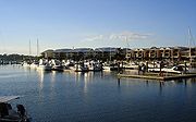
ramps, marina
Marina
A marina is a dock or basin with moorings and supplies for yachts and small boats.A marina differs from a port in that a marina does not handle large passenger ships or cargo from freighters....
s and jetties, including the Shorncliffe pier
Shorncliffe pier
Shorncliffe pier is situated in the suburb of Shorncliffe, Australia near Saint Patrick’s College the private school and lower Moora Park. This pier with its white faded timber railings, colonial street lamps spaced out along the stretch of pier, and resting shelter towards the end is a much...
.
Protected areas
Moreton Island is protected as Moreton Island National ParkMoreton Island National Park
Moreton Island National Park is a national park which covers 98% of Moreton Island in Queensland, Australia, 58 km northeast of Brisbane. It has three main townships, Bulwer, Cowan Cowan and Kooringal....
. The bay itself contains St Helena Island National Park
St Helena Island National Park
St Helena Island is an island in Queensland, Australia, 21 km east of Brisbane in Moreton Bay. Originally used as a prison, it is now a national park. Named Noogoon by the Australian Aborigines, it was renamed St Helena after an aboriginal named Napoleon was exiled there in 1826. The island...
and the Moreton Bay Marine Park
Moreton Bay Marine Park
The Moreton Bay Marine Park was established in 1992 to protect ecologically significant habitats in Moreton Bay. The World Heritage listed park extends from Caloundra south to the Gold Coast Seaway. The park's border extends up to the highest tidal mark and covers a total of 3400 km2.The park...
with areas designated under the Marine Park Zoning Plan. The Marine Park was declared in 1993 and covers 3400 square kilometres. Parts of the bay are also protected under the Southern Moreton Bay Islands National Park
Southern Moreton Bay Islands National Park
Southern Moreton Bay Islands is a national park in Queensland, Australia, 44 km southeast of Brisbane. It forms part of the Moreton Bay and Pumicestone Passage Important Bird Area, so identified by BirdLife International because it supports large numbers of migratory waders, or shorebirds....
. According to the Ramsar Wetland Convention 1971
Ramsar Convention
The Ramsar Convention is an international treaty for the conservation and sustainable utilization of wetlands, i.e., to stem the progressive encroachment on and loss of wetlands now and in the future, recognizing the fundamental ecological functions of wetlands and their economic, cultural,...
, parts of Moreton Bay are listed as a wetland
Wetland
A wetland is an area of land whose soil is saturated with water either permanently or seasonally. Wetlands are categorised by their characteristic vegetation, which is adapted to these unique soil conditions....
of international importance.
To make up for the fishing areas lost to the 2009 expansion of the Moreton Bay Marine Park, the Queensland Government agreed to create a total of six artificial reefs for anglers. The reefs are constructed from specially designed balls of concrete which will provide habitat for fish species. According to former Sustainability Minister Andrew McNamara
Andrew McNamara
Andrew Ian McNamara is an Australian politician. He was a Labor member of the Queensland Legislative Assembly from 2001 to 2009, representing the district of Hervey Bay...
the bay produces a commercial catch valued at A$25 million and that $4 million worth of this figure has become off-limits with the rezoning.
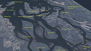
Sandbanks
Moreton Bay is filled with sandbanks. Between Tangalooma and Skirmish Point on Bribie Island are the Middle Banks, Central Banks and Western Banks. From north of Moreton Island towards Caloundra are the Yulle Road, Spitfire Bank, and the Salamander Bank, amongst others.Amity Banks are found just west of Amity Point, while the Moreton Banks lie to the west of the southern tip of Moreton Island. These banks can be hazard for marine navigation because they are constantly changing due to tidal currents.

Sand
Sand is a naturally occurring granular material composed of finely divided rock and mineral particles.The composition of sand is highly variable, depending on the local rock sources and conditions, but the most common constituent of sand in inland continental settings and non-tropical coastal...
for large projects such as the nearby Brisbane Airport
Brisbane Airport
Brisbane Airport is the sole passenger airport serving Brisbane and the third busiest in Australia, after Melbourne and Sydney Airports. Brisbane Airport has won many awards. Located in the suburb with the same name, the airport serves the city of Brisbane and the surrounding metropolitan area...
and port facilities. Past dredging has removed 18 Mn3 and the removal of another 40 Mn3 is planned. Future sand extraction is expected to aid a major shipping channel straightening project.
To ensure the shipping channel remains open, several areas of the bay have been allocated for dredged material dumping sites. These sites have been selected to provide beach nourishment
Beach nourishment
Beach nourishment— also referred to as beach replenishment—describes a process by which sediment lost through longshore drift or erosion is replaced from sources outside of the eroding beach...
, aiding the natural long shore transport of sand along ocean beaches.
Events
In 1949, the first annual Brisbane to Gladstone yacht raceBrisbane to Gladstone yacht race
The Brisbane to Gladstone yacht race is held annually, starting on Good Friday. The premier blue water classic begins from Shorncliffe in Moreton Bay, Queensland, Australia and finishes in Gladstone Harbour. It attracts competitors from interstate and usually attracts a fleet of 40 to 100 boats....
was held starting in Moreton Bay. This event is a popular sailing event held on the bay and is one of many that occur. There are several other sailing events held throughout the bay, generally starting from the Manly Royal Queensland Yacht Squadron. Recreational fishing is a big part of the bay's history and there is an annual Moreton Bay Classic
Moreton Bay Classic
The Moreton Bay Classic is a yearly fishing competition run by Brisbane Fishing Online held in Moreton Bay in South East Queensland, Australia. It is being held in May is now a two day event, longer than the previous year's one day event...
fishing competition run by Brisbane Fishing Online held from the Manly foreshore. The bay is home to many watersports and activities including jet-skiing, windsurfing and water-skiing. Snorkelling is especially popular around Tangalooma on Moreton Island as well.
Flora and fauna
The bay's heritage protected wetlands, mudflats, and waterways are some of the healthiest in the region, supporting seasonally up to 25 % of Australia's bird species. Collectively, around 50,000 wading birds visit the Moreton Bay each year, and its wetlands are classified by BirdLife InternationalBirdLife International
BirdLife International is a global Partnership of conservation organisations that strives to conserve birds, their habitats and global biodiversity, working with people towards sustainability in the use of natural resources...
as an Important Bird Area
Important Bird Area
An Important Bird Area is an area recognized as being globally important habitat for the conservation of bird populations. Currently there are about 10,000 IBAs worldwide. The program was developed and sites are identified by BirdLife International...
(IBA). The bay is also home to other abundant wildlife, including whale
Whale
Whale is the common name for various marine mammals of the order Cetacea. The term whale sometimes refers to all cetaceans, but more often it excludes dolphins and porpoises, which belong to suborder Odontoceti . This suborder also includes the sperm whale, killer whale, pilot whale, and beluga...
s, dolphin
Dolphin
Dolphins are marine mammals that are closely related to whales and porpoises. There are almost forty species of dolphin in 17 genera. They vary in size from and , up to and . They are found worldwide, mostly in the shallower seas of the continental shelves, and are carnivores, mostly eating...
s, dugong
Dugong
The dugong is a large marine mammal which, together with the manatees, is one of four living species of the order Sirenia. It is the only living representative of the once-diverse family Dugongidae; its closest modern relative, Steller's sea cow , was hunted to extinction in the 18th century...
, shark
Shark
Sharks are a type of fish with a full cartilaginous skeleton and a highly streamlined body. The earliest known sharks date from more than 420 million years ago....
s and turtles.
The Loggerhead turtle population in the bay is the most significant in the country. Dugongs and turtles, which are attracted to the seagrass
Seagrass
Seagrasses are flowering plants from one of four plant families , all in the order Alismatales , which grow in marine, fully saline environments.-Ecology:...
meadows for food, are threatened due to being prone to boat strike impacts. Moreton Bay is the only place in Australia where dugongs gather in herds. In the past the dugongs in herds numbered in the thousands. Some herds 5 km long by 250 m wide, were seen during the 1800s. In 2009, there was just between 600 and 800 remaining.
The bay is popular with recreational anglers
Angling
Angling is a method of fishing by means of an "angle" . The hook is usually attached to a fishing line and the line is often attached to a fishing rod. Fishing rods are usually fitted with a fishing reel that functions as a mechanism for storing, retrieving and paying out the line. The hook itself...
. The Moreton Bay bug
Moreton Bay bug
Thenus orientalis is a species of slipper lobster from the Indian and Pacific oceans.T. orientalis is known by a number of common names. The United Nations' Food and Agriculture Organization prefers the name flathead lobster, while the official Australian name is Bay lobster...
(Thenus orientalis) is a species of slipper lobster
Slipper lobster
Slipper lobsters are a family of decapod crustaceans found in all warm oceans and seas. Despite their name, they are not true lobsters, but are more closely related to spiny lobsters and furry lobsters. Slipper lobsters are instantly recognisable by their enlarged antennae, which project forward...
found throughout the waters of Australia's north coast. The Bug is a relatively expensive delicacy served in many restaurants in Queensland. The Moreton Bay Fig
Moreton Bay Fig
Ficus macrophylla, commonly known as the Moreton Bay Fig, is a large evergreen banyan tree of the Moraceae family that is a native of most of the eastern coast of Australia, from the Atherton Tableland in the north to the Illawarra in New South Wales, and Lord Howe Island. Its common name is...
(Ficus macrophylla) is endemic to the east coast of Australia within a range centred on Moreton Bay.
The southern and western parts of the bay contain shallow mud-layered waters that are protected from strong wave action by the barrier islands. This has provided excellent habitat for mangroves of which seven different species thrive within the bay. About 1% of the bay is coral reef. Land clearing and settlement in the catchment has led to unfavourable conditions for coral growth. Climate change is expected to raise sea levels and produce warmer waters that will aid coral growth in the bay. The bay may experience widespread outbreaks of bacteria lyngbya
Lyngbya
Lyngbya is a genus of cyanobacteria, unicellular autotrophs that form the basis of the oceanic food chain.Lyngbya form long unbranching filaments inside a rigid mucilage sheath. Sheaths may form tangles or mats, intermixed with other phytoplankton species...
which can cause skin lesions and asthma attacks upon contact.
External links
- SEQ History South East Queensland History
- Moreton Bay Database - a detailed chronicle of events
- BayJournal An online news source publishing one story a day about the Bay.
- Australian Folk Songs: Moreton Bay Folk song about the penal colony at Moreton Bay
- Pencil drawing of Moreton Bay settlement, ca. 1835 by Henry Boucher Bowerman. Digitised and held by Heritage Collections, State Library of QueenslandState Library of QueenslandThe State Library of Queensland is a large public library provided to the people of the State of Queensland, Australia, by the state government. Its legislative basis is provided by the Queensland Libraries Act 1988...
.