
Kaaterskill High Peak
Encyclopedia
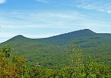
Kaaterskill High Peak is one of the Catskill Mountains
, located in the Town of Hunter
in Greene County
, New York
, USA. It was once believed to be the highest peak in the entire range, but its summit, at 3,655 feet (1,114 m) in elevation, places it only 23rd among the Catskill High Peaks
. It is, however, the fourth most prominent
peak in the range. Due to its situation as the easternmost High Peak, it is also the only one completely outside the watershed
s of New York City
's reservoirs in the region.
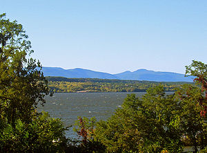
Along with Round Top to the west, its distinctive ridgeline is a visual signature of the Catskills. Even today, it dominates the view of the range from the Hudson Valley
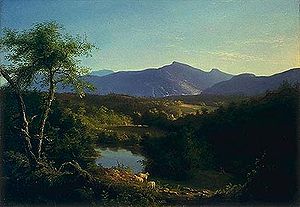
. In the early 19th century, it was a frequent subject of works by Thomas Cole
and other artists of the Hudson River school
. Their works helped establish the Catskill Mountain House
and other hotels around North-South Lake
as the fashionable summer vacation spot for wealthy Americans of the era.
Despite that popularity, the mountain was admired from afar more often than it was climbed. Although it boasts the earliest recorded ascent of any Catskill peak, today it seems somewhat neglected, lacking an official trail to its summit. However, a well-used path does exist, and perhaps because of the light use the mountain gets it is very popular with the area's serious hikers, due to the views available from Hurricane Ledge south of the summit, and several other points of interest in the vicinity of the mountain.
In the latter years of the 18th century, the peak was known as Liberty Cap for its similarity to the Phrygian cap
popular during the American
and French
revolution
s.
, the sudden rise of the peaks from the Hudson Valley floor. From the valley, it is easy to understand how it came to be seen as the highest peak in the Catskills, since there are no higher peaks close to it. It is bracketed by the only two gaps in the Escarpment — Platte Clove
to the south and Kaaterskill Clove
to the north.
As a mountain High Peak is somewhat unusual. Its slopes are spread out and rise gently for some distance, then a bit more steeply, to the summit dome, which is surrounded by rock cliffs at about 3,500 feet (1,067 m) in elevation. Above them the ground again curves gently upward to the summit, roughly at the dome's center.
Drainage
from the north flows into Kaaterskill Creek
, from the south to Plattekill Creek, both of which reach the Hudson River
shortly afterwards without any major impoundment
.
While High Peak is not among the highest Catskill peaks, because of its distance from other major peaks it ranks fourth in topographic prominence
, after Slide Mountain
, Hunter Mountain
and Black Dome
. High Peak's summit rises 1,775 feet (541 m) from the lowest elevation contour line
that encircles it.
between the two qualify it as a separate peak entirely, it remains strongly enough associated with High Peak that it is often treated as its lower summit.
"agent" and frequent visitor to the nearby Clermont
estate of Chancellor Robert Livingston
, who published him regularly in Transactions, the journal of the Society for the Promotion of Agriculture, Arts and Manufactures. One of DeLaBigarre's accounts in 1794 described his adventures in the Catskills the year before. Most of his narrative was given over to a springtime trip to Overlook Mountain and North-South Lake
, but on the later day he records that he brought a "natural philosopher" friend along with a barometer
and climbed "Round Top", which he believed to be the highest Catskill peak, renaming it Liberty Cap in honor of the political change in his homeland. The companion determined the mountain's summit to be 3,549 feet (1,082 m) above sea level
, only about 106 feet (32 m) short of its accepted elevation today. This is the earliest recorded climb of any Catskill High Peak
.
 His visit and account laid the groundwork for the early years of the next century, when a young Thomas Cole
would visit the Catskill Mountain House
and devote much of his groundbreaking Hudson River School
painting
s to depictions of the Catskill wilderness. High Peak, visible from the Mountain House as well as from the studio
and home he built in Catskill
, would frequently show up in the background. The popularity of his art in turn brought more guests to the Mountain House (and later, the Kaaterskill and Laurel hotels) to see it for themselves.
One of those visitors, Princeton
geography
professor
Arnold Henry Guyot
, spent much of his summers in the early 1870s striking out to other mountains in the region. He easily became convinced that High Peak was not, as the hoteliers claimed, the high peak of the Catskills. His candidates turned first to other popular local suspects such as Black Dome
(known as "Black Top" at the time), then Hunter Mountain
and finally to Slide Mountain
, in an inland area to the southwest known at the time as the Shandaken
Mountains and dismissed by the hotelkeepers as a different range entirely.
He brought his surveying
equipment and assistants along, and wound up producing the first accurate map of the Catskill Mountains. Slide's 4,180 feet (1,277 m) put it well above High Peak, now consigned to 23rd on his list (he would also pioneer the switch in names between High Peak and Round Top, once he had established which was higher) The resort owners protested and tried to discredit his findings, but they were solid and by 1879 other surveyors had confirmed them. When New York established its Forest Preserve
several years later, a delegation from the state forestry board commemorated the event by climbing Slide, not High Peak. A privately-owned observation tower and neighboring two-story building were built on the summit in the late 19th century, but seem to have been removed sometime around state acquisition of the property two decades later.
Attention paid to the mountain dwindled, and even today it has no officially-maintained trail over its summit, though the "unofficial" Twilight Trail remains well-used and is blazed along most its length. In 1921 both High Peak and Round Top were added to the Forest Preserve.
The south slope of the mountain has seen some development and habitation over the years. A former New York City Police Department
camp near the top of Platte Clove was proposed as a site for a prison
when it was abandoned in the 1970s, but the plan was dropped after local opposition. Today it is one of the Bruderhof Communities
. There are still some private landholdings in the area.
A half-mile (1 km) horse-drawn railroad was once constructed on the south slopes below the col, following the brook by Byrne Road, to haul logs out of the area. Remnants of its steel
-topped wooden rails can still be found.
On the north slope, at the precarious head of Kaaterskill Clove
, is the community of Twilight Park.
Two small airplanes have crashed on the mountain in the later years of the 20th century. One of them, on May 26, 1983, killed a Watertown
man, Rex Miller, when he flew his Piper-28-140
into the mountain at about 3400 feet (1,036.3 m) in bad weather while attempting to return home from Poughkeepsie
.
The small Cortina Valley ski area, started in 1975 tried to make a go of it under several different ownerships on the northwestern slope of Round Top, but went out of business for good around 2000. The three trails still remain.
At some point, the state built a snowmobile
loop around both peaks, starting at the top of Platte Clove and leveling out at 3,200 feet (975 m). However, it sees little snowmobiler use even in the most severe winters. Recent proposed changes to the Catskill State Land Master Plan could result in the end of this designation.
More of the mountain has been added to the Forest Preserve over the years. It is managed by the New York State Department of Environmental Conservation
as part of the Kaaterskill Wild Forest management unit in Catskill Park.
slope forest in which beech
, birch
and maple
predominate. The summit dome of both High Peak and Round Top are likewise home to a boreal forest of balsam fir
and red spruce
, with paper birch
as a deciduous
associate species. Despite the heavy development of the mountain, much of the forest above 3,000 feet (914 m) is first-growth.
Spruce, fir and pines also predominate in an area called Pine Plains, roughly due east and east-northeast of the summit, just below 3000 feet (914.4 m) near high ground along the Escarpment. Poor drainage here gives these species opportunities they would not otherwise have at that point. It remains wet and muddy even through dry weather, and in late spring it is often one of the best places to see some of the wildflower
species of the Catskills, such as trillium
and clintonia
.
long-distance hiking trail
. The southern route is still overwhelmingly preferred due to its gentle, almost level climb for much of its distance, allowing hikers to build up a good pace for a determined take on the summit. The northern route passes several scenic waterfalls and overlooks and requires almost 3000 feet (914.4 m) of elevation gain, the most possible on any route up a major Catskill peak.
A shorter third route from the south is possible if permission to cross private land is obtained first. All depend to some extent on the snowmobile trail. The unofficial Twilight Park Trail (named for a private residential community at the head of Kaaterskill Clove, at its northern end) is used in all cases to gain the summit.
both with large orange plastic discs for snowmobiles (rarely seen) and smaller blue ones for foot users (A color given on all DEC lands to sections of the Long Path not part of other designated trails). The cascades
of a nearby tributary
of Platte Creek beckon through hemlock
stands, but are on private land. Vehicle tracks can still be seen as there are several forks leading to private homes in the area, usually chained off. Elevation gain is noticeable, but comes at a slight though steady pace.
At the last fork, a mile (1.6 km) from the trailhead a state sign indicates the distances to Palenville
, the next place the Long Path reaches civilization, and other points of interest on the far side of the mountain. From this point on the trail becomes narrower as it is barred to all other motor vehicles, and starts to curve to the northeast, into state land. A yellow-blazed spur, the former Nature Friends
Trail, only recently added to the state system, leads to the scenic Huckleberry Point overlook after a while.
The travel levels off from its gentle climb, and starts heading due north, as it crosses some brooks and the hemlock stands around them. Postings marking the back bounds of some private lots are still visible through the distance, as are some unauthorized trails to those lands. Finally some more gentle ascending into a more beech
-dominant forest heralds the beginning of Pine Plains, 1.25 miles (2 km) from the Huckleberry Point junction, as the trail also begins to curve to the west.
Spruce, fir and other evergreens become much more common in this somewhat distressed environment, where the trail is often quite wet. Yet the scenery makes it worth the effort for many hikers, especially with the wildflower sightings possible here in the late spring.
Beyond Pine Plains, the forest returns to a more deciduous
character as the trail remains level while becoming decidedly westward in heading, crossing many rivulets or streambeds, some offering picturesque mini-cascades of their own. Finally, at a junction 3.7 miles (6 km) from the trailhead, the Long Path drops down into Kaaterskill Clove
while the snowmobile route heads up a slightly steeper slope. After several hundred feet (about a hundred meters), it reaches the loop.
From here, hikers can take one of two routes: either turn right (west), walk several hundred yards, and look carefully for a pair of cairn
s in the woods on your left marking the north end of the Twilight Park Trail (not yet official, but well-marked) OR turn left and proceed around the mountain, past one of the easily spotted plane wrecks. As the path curves to the right, you will eventually encounter a 5 feet (1.5 m) cairn in the middle of the path marking the south end of the Twilight Park Trail. A combination of smaller cairns, surveyor
's tape flags and old blue paint blazes have been used by various stealth maintainers over the years to keep this wet and sometimes hard-to-spot route marked. While not seriously steep, it is almost constantly ascending, responsible for the last 450 vertical feet up the mountain in less than a mile. The southerly approach is probably best, since the steepest portions of the ascent are to the south and are best handled going up rather than down.
It begins by winding through the notably scrubbier woods of these slopes before finally settling for a traverse up past some impressive rock outcrops, where it becomes more heavily trodden and easier to follow. Finally, just above 3500 feet (1,066.8 m), it reaches a short but steep open rock face that requires some scrambling
to reward the climber with a view to the north of the Blackhead Range
, over Kaaterskill Clove, with Kaaterskill Falls clearly visible below.
Beyond it the path becomes even more obvious as the surrounding forest becomes totally boreal, with spruce and fir in every direction. Some gentle ascents alternate with level stretches before a last ascent into the small, viewless summit clearing. Distance is roughly 5 miles (8 km) from the trailhead, with a vertical gain of 1,455 feet (443 m).
Upon return, some hikers using this route prefer to either continue south along the Twilight Park Trail to the loop, or remain on the loop (which is often as wet as Pine Plains below it) to the plane wreckage at the loop's southeastern corner and bushwhack from there down to the trail just past Pine Plains in order to save some time and distance.
. A woods road with the aqua
blazes of the Long Path begins just past its end. It ascends, steadily and sometimes steeply, for two miles (3.2 km) up the side of Kaaterskill Clove. The trail switches back at the top of a small rise and begins to descend slightly to the two streams at the base of Hillyer Ravine.
After a half-mile (1 km) ascent, the trail reaches Wildcat Falls, where a ledge offers an excellent view down into Kaaterskill Clove. Another half-mile produces Buttermilk Falls, a two-step waterfall just off-trail. Just 0.2 mile (800 m) later, the old road ends and the trail begins to seriously climb over some steep slopes and narrow ledges. This continues for 0.65 mile (1 km) before joining the Twilight Park Trail. The junction with the snowmobile trail is another 0.2 mile (0.321868 km) uphill.
Via this route, it is approximately 7 miles (11.2 km) to the summit and 2,990 vertical feet (911 m).
The ascent from that point follows the same route and terrain described in the southern approach above.
benchmarks
at the 3655 feet (1,114 m) elevation marking the highest point on the mountain; the bolts themselves are on rocks in the nearby woods (one is on the southern trail five feet from the peak, the other is about 10 feet (3 m) to the south in the woods).
and Twin
mountains in the Devil's Path
can be seen to the immediate south (the latter's summit appearing lower than High Peak even though it is not), with Plateau bookending them to the west. On the east, the Catskills drop away dramatically into the clove and a long section of the Hudson is visible.
The area is named either for the 1950 storm
that supposedly cleared the view by blowing most of the trees down, or for the strong winds felt due to the absence of trees. It is the only area of the Catskills that feels as if it were above tree line.
. Its summit can be reached by use paths similar to those on its neighbor (although unmaintained), from the snowmobile trail near Cortina Valley.
during the French and Indian War
, it was most famously used by Tories and their Indian
allies later during the Revolutionary War
(in the early years of which pro-British sentiment was quite common in the region, as many of its tenant farmer
s despised their pro-independence landlord
s). From that vantage point they could see down into Platte Clove and keep an eye on troop movements in the valley (likewise strongly pro-Patriot).
It was often the first stop for many taken prisoner during engagements in the region who were later transported to what is now Canada
to be exchanged, paroled or ransomed, as reported in many captivity narrative
s. Joseph Brant
, the legendary Indian warrior who fought for the British, stopped by for a visit once, giving rise in later years to legends that he based his fearsome raids here. The fort has been informally named for him ever since even though his real involvement with it was minimal.
challenge. The lower of the two on High Peak is one of the more easily reached since it sits right on the snowmobile loop, and much of the fuselage
remains since removing the wreckage is not a priority for NYSDEC and its limited funding. It was briefly the site of a geocache
, but DEC removed it as it was prohibited by Forest Preserve regulations.
The upper one is more of a challenge to find due to its location on the cliffs east of the summit. Faint paths can be followed to it, however, and a small piece of it was for a long time placed on the rock with the reference marker at the summit.
Catskill Mountains
The Catskill Mountains, an area in New York State northwest of New York City and southwest of Albany, are a mature dissected plateau, an uplifted region that was subsequently eroded into sharp relief. They are an eastward continuation, and the highest representation, of the Allegheny Plateau...
, located in the Town of Hunter
Hunter (town), New York
Hunter is a town in Greene County, New York. The population was 2,732 at the 2010 census.The Town of Hunter contain two villages one named Hunter and the other called Tannersville. The town is on the County's south border.- History :...
in Greene County
Greene County, New York
Greene County is a county located in the U.S. state of New York. Its name is in honor of the American Revolutionary War general Nathanael Greene. Its county seat is Catskill...
, New York
New York
New York is a state in the Northeastern region of the United States. It is the nation's third most populous state. New York is bordered by New Jersey and Pennsylvania to the south, and by Connecticut, Massachusetts and Vermont to the east...
, USA. It was once believed to be the highest peak in the entire range, but its summit, at 3,655 feet (1,114 m) in elevation, places it only 23rd among the Catskill High Peaks
Catskill High Peaks
The Catskill High Peaks are all of the mountains in New York's Catskill Mountains above 3,500 ft in elevation whose summits are separated either by one-half mile or a vertical drop of at least 250 ft between it and the next nearest separate summit...
. It is, however, the fourth most prominent
Topographic prominence
In topography, prominence, also known as autonomous height, relative height, shoulder drop , or prime factor , categorizes the height of the mountain's or hill's summit by the elevation between it and the lowest contour line encircling it and no higher summit...
peak in the range. Due to its situation as the easternmost High Peak, it is also the only one completely outside the watershed
Drainage basin
A drainage basin is an extent or an area of land where surface water from rain and melting snow or ice converges to a single point, usually the exit of the basin, where the waters join another waterbody, such as a river, lake, reservoir, estuary, wetland, sea, or ocean...
s of New York City
New York City
New York is the most populous city in the United States and the center of the New York Metropolitan Area, one of the most populous metropolitan areas in the world. New York exerts a significant impact upon global commerce, finance, media, art, fashion, research, technology, education, and...
's reservoirs in the region.
Along with Round Top to the west, its distinctive ridgeline is a visual signature of the Catskills. Even today, it dominates the view of the range from the Hudson Valley
Hudson Valley
The Hudson Valley comprises the valley of the Hudson River and its adjacent communities in New York State, United States, from northern Westchester County northward to the cities of Albany and Troy.-History:...
. In the early 19th century, it was a frequent subject of works by Thomas Cole
Thomas Cole
Thomas Cole was an English-born American artist. He is regarded as the founder of the Hudson River School, an American art movement that flourished in the mid-19th century...
and other artists of the Hudson River school
Hudson River school
The Hudson River School was a mid-19th century American art movement embodied by a group of landscape painters whose aesthetic vision was influenced by romanticism...
. Their works helped establish the Catskill Mountain House
Catskill Mountain House
The Catskill Mountain House was a famous hotel near Palenville, New York in the Catskill Mountains overlooking the Hudson River Valley, built in 1824. In its prime, from the 1850s to the turn of the century, it was visited by three U.S. presidents The Catskill Mountain House was a famous hotel...
and other hotels around North-South Lake
North-South Lake
North-South Lake is an 1,100-acre state campground in the Catskill Forest Preserve near Palenville, New York operated by the New York State Department of Environmental Conservation near the site of the historic Catskill Mountain House overlooking the Hudson River...
as the fashionable summer vacation spot for wealthy Americans of the era.
Despite that popularity, the mountain was admired from afar more often than it was climbed. Although it boasts the earliest recorded ascent of any Catskill peak, today it seems somewhat neglected, lacking an official trail to its summit. However, a well-used path does exist, and perhaps because of the light use the mountain gets it is very popular with the area's serious hikers, due to the views available from Hurricane Ledge south of the summit, and several other points of interest in the vicinity of the mountain.
Name
Originally, High Peak and Round Top had each others' names, due to the clear difference in topography between their summits. However, since what was called Round Top is clearly the higher of the two, confusion developed over which of the two peaks was really "High Peak". In the late 19th century, the higher peak officially became High Peak and the lower one Round Top. The "Kaaterskill" is from the nearby creek and clove, in order to distinguish it from other "High Peaks" and "Round Tops" in the range.In the latter years of the 18th century, the peak was known as Liberty Cap for its similarity to the Phrygian cap
Phrygian cap
The Phrygian cap is a soft conical cap with the top pulled forward, associated in antiquity with the inhabitants of Phrygia, a region of central Anatolia. In the western provinces of the Roman Empire it came to signify freedom and the pursuit of liberty, perhaps through a confusion with the pileus,...
popular during the American
American Revolution
The American Revolution was the political upheaval during the last half of the 18th century in which thirteen colonies in North America joined together to break free from the British Empire, combining to become the United States of America...
and French
French Revolution
The French Revolution , sometimes distinguished as the 'Great French Revolution' , was a period of radical social and political upheaval in France and Europe. The absolute monarchy that had ruled France for centuries collapsed in three years...
revolution
Revolution
A revolution is a fundamental change in power or organizational structures that takes place in a relatively short period of time.Aristotle described two types of political revolution:...
s.
Geography
High Peak stands slightly apart from other major peaks in the Catskills, squarely in the middle of the Catskill EscarpmentCatskill Escarpment
The Catskill Escarpment, often referred to locally as just the Escarpment or the Great Wall of Manitou, and known as the Catskill Front to geologists, is the range forming the northeastern corner of the Catskill Mountains in Greene and Ulster counties in the U.S. state of New York...
, the sudden rise of the peaks from the Hudson Valley floor. From the valley, it is easy to understand how it came to be seen as the highest peak in the Catskills, since there are no higher peaks close to it. It is bracketed by the only two gaps in the Escarpment — Platte Clove
Platte Clove
Platte Clove, sometimes Plattekill Clove, is a narrow and steep valley in the Catskill Mountains of New York. It is mostly in Greene County, although the lowest portions are in Ulster County....
to the south and Kaaterskill Clove
Kaaterskill Clove
Kaaterskill Clove is a deep gorge, or valley, in New York's eastern Catskill Mountains, lying just west of the village of Palenville. The clove was formed by Kaaterskill Creek, a tributary of Catskill Creek rising west of North Mountain, and is estimated by geologists to be as much as 1 million...
to the north.
As a mountain High Peak is somewhat unusual. Its slopes are spread out and rise gently for some distance, then a bit more steeply, to the summit dome, which is surrounded by rock cliffs at about 3,500 feet (1,067 m) in elevation. Above them the ground again curves gently upward to the summit, roughly at the dome's center.
Drainage
Drainage
Drainage is the natural or artificial removal of surface and sub-surface water from an area. Many agricultural soils need drainage to improve production or to manage water supplies.-Early history:...
from the north flows into Kaaterskill Creek
Kaaterskill Creek
Kaaterskill Creek is a tributary of Catskill Creek in Greene and Ulster counties in New York. Via Catskill Creek, it is part of the Hudson River watershed....
, from the south to Plattekill Creek, both of which reach the Hudson River
Hudson River
The Hudson is a river that flows from north to south through eastern New York. The highest official source is at Lake Tear of the Clouds, on the slopes of Mount Marcy in the Adirondack Mountains. The river itself officially begins in Henderson Lake in Newcomb, New York...
shortly afterwards without any major impoundment
Dam
A dam is a barrier that impounds water or underground streams. Dams generally serve the primary purpose of retaining water, while other structures such as floodgates or levees are used to manage or prevent water flow into specific land regions. Hydropower and pumped-storage hydroelectricity are...
.
While High Peak is not among the highest Catskill peaks, because of its distance from other major peaks it ranks fourth in topographic prominence
Topographic prominence
In topography, prominence, also known as autonomous height, relative height, shoulder drop , or prime factor , categorizes the height of the mountain's or hill's summit by the elevation between it and the lowest contour line encircling it and no higher summit...
, after Slide Mountain
Slide Mountain (New York)
Slide Mountain is the highest peak in the Catskills. It is located in the Town of Shandaken in Ulster County, in southern New York. While the contour line on topographic maps is generally accepted as its height, the exact elevation of the summit has never been officially determined by the U.S...
, Hunter Mountain
Hunter Mountain (New York)
Hunter Mountain is in the towns of Hunter and Lexington, just south of the village of Hunter, in Greene County, New York, USA. At approximately 4,040 feet in elevation, it is the highest peak in the county and the second-highest peak in the Catskill Mountains.While the mountain is closely...
and Black Dome
Black Dome (New York)
Black Dome is a mountain located in Greene County, New York.The mountain is the highest peak of the Blackhead Mountains range of the Catskills.Black Dome is flanked to the east by Blackhead, and to the west by Thomas Cole Mountain....
. High Peak's summit rises 1,775 feet (541 m) from the lowest elevation contour line
Contour line
A contour line of a function of two variables is a curve along which the function has a constant value. In cartography, a contour line joins points of equal elevation above a given level, such as mean sea level...
that encircles it.
Round Top
The former High Peak, now Round Top, is an approximately 3,440-foot (1,049-m) summit located roughly a mile (1.6 km) west of High Peak's summit. While its distance and vertical separation from the colMountain pass
A mountain pass is a route through a mountain range or over a ridge. If following the lowest possible route, a pass is locally the highest point on that route...
between the two qualify it as a separate peak entirely, it remains strongly enough associated with High Peak that it is often treated as its lower summit.
History
The first recorded ascent of Kaaterskill High Peak took place on July 26, 1793 when Peter DeLaBigarre, a FrenchFrench people
The French are a nation that share a common French culture and speak the French language as a mother tongue. Historically, the French population are descended from peoples of Celtic, Latin and Germanic origin, and are today a mixture of several ethnic groups...
"agent" and frequent visitor to the nearby Clermont
Clermont, New York
Clermont is a town in Columbia County, New York, United States. The population was 1,726 at the 2000 census. The name of the town is French for "Clear Mountain," referring to the mountain views in the town....
estate of Chancellor Robert Livingston
Robert Livingston (1746-1813)
Robert R Livingston was an American lawyer, politician, diplomat from New York, and a Founding Father of the United States. He was known as "The Chancellor," after the office he held for 25 years....
, who published him regularly in Transactions, the journal of the Society for the Promotion of Agriculture, Arts and Manufactures. One of DeLaBigarre's accounts in 1794 described his adventures in the Catskills the year before. Most of his narrative was given over to a springtime trip to Overlook Mountain and North-South Lake
North-South Lake
North-South Lake is an 1,100-acre state campground in the Catskill Forest Preserve near Palenville, New York operated by the New York State Department of Environmental Conservation near the site of the historic Catskill Mountain House overlooking the Hudson River...
, but on the later day he records that he brought a "natural philosopher" friend along with a barometer
Barometer
A barometer is a scientific instrument used in meteorology to measure atmospheric pressure. Pressure tendency can forecast short term changes in the weather...
and climbed "Round Top", which he believed to be the highest Catskill peak, renaming it Liberty Cap in honor of the political change in his homeland. The companion determined the mountain's summit to be 3,549 feet (1,082 m) above sea level
Sea level
Mean sea level is a measure of the average height of the ocean's surface ; used as a standard in reckoning land elevation...
, only about 106 feet (32 m) short of its accepted elevation today. This is the earliest recorded climb of any Catskill High Peak
Catskill High Peaks
The Catskill High Peaks are all of the mountains in New York's Catskill Mountains above 3,500 ft in elevation whose summits are separated either by one-half mile or a vertical drop of at least 250 ft between it and the next nearest separate summit...
.
Thomas Cole
Thomas Cole was an English-born American artist. He is regarded as the founder of the Hudson River School, an American art movement that flourished in the mid-19th century...
would visit the Catskill Mountain House
Catskill Mountain House
The Catskill Mountain House was a famous hotel near Palenville, New York in the Catskill Mountains overlooking the Hudson River Valley, built in 1824. In its prime, from the 1850s to the turn of the century, it was visited by three U.S. presidents The Catskill Mountain House was a famous hotel...
and devote much of his groundbreaking Hudson River School
Hudson River school
The Hudson River School was a mid-19th century American art movement embodied by a group of landscape painters whose aesthetic vision was influenced by romanticism...
painting
Painting
Painting is the practice of applying paint, pigment, color or other medium to a surface . The application of the medium is commonly applied to the base with a brush but other objects can be used. In art, the term painting describes both the act and the result of the action. However, painting is...
s to depictions of the Catskill wilderness. High Peak, visible from the Mountain House as well as from the studio
Studio
A studio is an artist's or worker's workroom, or the catchall term for an artist and his or her employees who work within that studio. This can be for the purpose of architecture, painting, pottery , sculpture, scrapbooking, photography, graphic design, filmmaking, animation, radio or television...
and home he built in Catskill
Catskill (village), New York
Catskill is a village in Greene County, New York, USA. The population was 4,081 at the 2010 census.The Village of Catskill is in the northeast part of the Town of Catskill. Catskill is the county seat of Greene County.-History:...
, would frequently show up in the background. The popularity of his art in turn brought more guests to the Mountain House (and later, the Kaaterskill and Laurel hotels) to see it for themselves.
One of those visitors, Princeton
Princeton University
Princeton University is a private research university located in Princeton, New Jersey, United States. The school is one of the eight universities of the Ivy League, and is one of the nine Colonial Colleges founded before the American Revolution....
geography
Geography
Geography is the science that studies the lands, features, inhabitants, and phenomena of Earth. A literal translation would be "to describe or write about the Earth". The first person to use the word "geography" was Eratosthenes...
professor
Professor
A professor is a scholarly teacher; the precise meaning of the term varies by country. Literally, professor derives from Latin as a "person who professes" being usually an expert in arts or sciences; a teacher of high rank...
Arnold Henry Guyot
Arnold Henry Guyot
Arnold Henry Guyot was a Swiss-American geologist and geographer.-Biography:...
, spent much of his summers in the early 1870s striking out to other mountains in the region. He easily became convinced that High Peak was not, as the hoteliers claimed, the high peak of the Catskills. His candidates turned first to other popular local suspects such as Black Dome
Black Dome (New York)
Black Dome is a mountain located in Greene County, New York.The mountain is the highest peak of the Blackhead Mountains range of the Catskills.Black Dome is flanked to the east by Blackhead, and to the west by Thomas Cole Mountain....
(known as "Black Top" at the time), then Hunter Mountain
Hunter Mountain (New York)
Hunter Mountain is in the towns of Hunter and Lexington, just south of the village of Hunter, in Greene County, New York, USA. At approximately 4,040 feet in elevation, it is the highest peak in the county and the second-highest peak in the Catskill Mountains.While the mountain is closely...
and finally to Slide Mountain
Slide Mountain (New York)
Slide Mountain is the highest peak in the Catskills. It is located in the Town of Shandaken in Ulster County, in southern New York. While the contour line on topographic maps is generally accepted as its height, the exact elevation of the summit has never been officially determined by the U.S...
, in an inland area to the southwest known at the time as the Shandaken
Shandaken, New York
Shandaken is a town in Ulster County, New York, United States. United States. As of the 2000 census, the town had a total population of 3,235. The name is from a native phrase for "land of rapid waters."...
Mountains and dismissed by the hotelkeepers as a different range entirely.
He brought his surveying
Surveying
See Also: Public Land Survey SystemSurveying or land surveying is the technique, profession, and science of accurately determining the terrestrial or three-dimensional position of points and the distances and angles between them...
equipment and assistants along, and wound up producing the first accurate map of the Catskill Mountains. Slide's 4,180 feet (1,277 m) put it well above High Peak, now consigned to 23rd on his list (he would also pioneer the switch in names between High Peak and Round Top, once he had established which was higher) The resort owners protested and tried to discredit his findings, but they were solid and by 1879 other surveyors had confirmed them. When New York established its Forest Preserve
Forest Preserve (New York)
New York's Forest Preserve is all the land owned by the state within the Adirondack and Catskill parks, managed by its Department of Environmental Conservation. These properties are required to be kept "forever wild" by Article 14 of the state constitution, and thus enjoy the highest degree of...
several years later, a delegation from the state forestry board commemorated the event by climbing Slide, not High Peak. A privately-owned observation tower and neighboring two-story building were built on the summit in the late 19th century, but seem to have been removed sometime around state acquisition of the property two decades later.
Attention paid to the mountain dwindled, and even today it has no officially-maintained trail over its summit, though the "unofficial" Twilight Trail remains well-used and is blazed along most its length. In 1921 both High Peak and Round Top were added to the Forest Preserve.
The south slope of the mountain has seen some development and habitation over the years. A former New York City Police Department
New York City Police Department
The New York City Police Department , established in 1845, is currently the largest municipal police force in the United States, with primary responsibilities in law enforcement and investigation within the five boroughs of New York City...
camp near the top of Platte Clove was proposed as a site for a prison
Prison
A prison is a place in which people are physically confined and, usually, deprived of a range of personal freedoms. Imprisonment or incarceration is a legal penalty that may be imposed by the state for the commission of a crime...
when it was abandoned in the 1970s, but the plan was dropped after local opposition. Today it is one of the Bruderhof Communities
Bruderhof Communities
The Bruderhof Communities are Christian religious communities with branches in New York, Florida and Pennsylvania in the US, the United Kingdom, Germany, and Australia. They have previously been called The Society of Brothers and were loosely affiliated with the Hutterian Brethren...
. There are still some private landholdings in the area.
A half-mile (1 km) horse-drawn railroad was once constructed on the south slopes below the col, following the brook by Byrne Road, to haul logs out of the area. Remnants of its steel
Steel
Steel is an alloy that consists mostly of iron and has a carbon content between 0.2% and 2.1% by weight, depending on the grade. Carbon is the most common alloying material for iron, but various other alloying elements are used, such as manganese, chromium, vanadium, and tungsten...
-topped wooden rails can still be found.
On the north slope, at the precarious head of Kaaterskill Clove
Kaaterskill Clove
Kaaterskill Clove is a deep gorge, or valley, in New York's eastern Catskill Mountains, lying just west of the village of Palenville. The clove was formed by Kaaterskill Creek, a tributary of Catskill Creek rising west of North Mountain, and is estimated by geologists to be as much as 1 million...
, is the community of Twilight Park.
Two small airplanes have crashed on the mountain in the later years of the 20th century. One of them, on May 26, 1983, killed a Watertown
Watertown (city), New York
Watertown is a city in the state of New York and the county seat of Jefferson County. It is situated approximately south of the Thousand Islands. As of the 2010 census, it had a population of 27,023, an increase of 1.2% since 2000. The U.S...
man, Rex Miller, when he flew his Piper-28-140
Piper Cherokee
The Piper PA-28 Cherokee is a family of light aircraft designed for flight training, air taxi, and personal use. It is built by Piper Aircraft....
into the mountain at about 3400 feet (1,036.3 m) in bad weather while attempting to return home from Poughkeepsie
Poughkeepsie (city), New York
Poughkeepsie is a city in the state of New York, United States, which serves as the county seat of Dutchess County. Poughkeepsie is located in the Hudson River Valley midway between New York City and Albany...
.
The small Cortina Valley ski area, started in 1975 tried to make a go of it under several different ownerships on the northwestern slope of Round Top, but went out of business for good around 2000. The three trails still remain.
At some point, the state built a snowmobile
Snowmobile
A snowmobile, also known in some places as a snowmachine, or sled,is a land vehicle for winter travel on snow. Designed to be operated on snow and ice, they require no road or trail. Design variations enable some machines to operate in deep snow or forests; most are used on open terrain, including...
loop around both peaks, starting at the top of Platte Clove and leveling out at 3,200 feet (975 m). However, it sees little snowmobiler use even in the most severe winters. Recent proposed changes to the Catskill State Land Master Plan could result in the end of this designation.
More of the mountain has been added to the Forest Preserve over the years. It is managed by the New York State Department of Environmental Conservation
New York State Department of Environmental Conservation
The New York State Department of Environmental Conservation is responsible for the conservation, improvement, and protection of natural resources within the U.S. state of New York. It was founded in 1970, replacing the previous Conservation Department...
as part of the Kaaterskill Wild Forest management unit in Catskill Park.
Natural environment
Typically for the Catskills, High Peak and much of the state land around it are covered with a northern-hardwoodHardwood
Hardwood is wood from angiosperm trees . It may also be used for those trees themselves: these are usually broad-leaved; in temperate and boreal latitudes they are mostly deciduous, but in tropics and subtropics mostly evergreen.Hardwood contrasts with softwood...
slope forest in which beech
Beech
Beech is a genus of ten species of deciduous trees in the family Fagaceae, native to temperate Europe, Asia and North America.-Habit:...
, birch
Birch
Birch is a tree or shrub of the genus Betula , in the family Betulaceae, closely related to the beech/oak family, Fagaceae. The Betula genus contains 30–60 known taxa...
and maple
Maple
Acer is a genus of trees or shrubs commonly known as maple.Maples are variously classified in a family of their own, the Aceraceae, or together with the Hippocastanaceae included in the family Sapindaceae. Modern classifications, including the Angiosperm Phylogeny Group system, favour inclusion in...
predominate. The summit dome of both High Peak and Round Top are likewise home to a boreal forest of balsam fir
Balsam Fir
The balsam fir is a North American fir, native to most of eastern and central Canada and the northeastern United States .-Growth:It is a small to medium-size evergreen tree typically tall, rarely to tall, with a narrow conic crown...
and red spruce
Red Spruce
Picea rubens is a species of spruce native to eastern North America, ranging from eastern Quebec to Nova Scotia, and from New England south in the Adirondack Mountains and Appalachians to western North Carolina.-Physical description:...
, with paper birch
Paper Birch
Betula papyrifera is a species of birch native to northern North America.-Description:...
as a deciduous
Deciduous
Deciduous means "falling off at maturity" or "tending to fall off", and is typically used in reference to trees or shrubs that lose their leaves seasonally, and to the shedding of other plant structures such as petals after flowering or fruit when ripe...
associate species. Despite the heavy development of the mountain, much of the forest above 3,000 feet (914 m) is first-growth.
Spruce, fir and pines also predominate in an area called Pine Plains, roughly due east and east-northeast of the summit, just below 3000 feet (914.4 m) near high ground along the Escarpment. Poor drainage here gives these species opportunities they would not otherwise have at that point. It remains wet and muddy even through dry weather, and in late spring it is often one of the best places to see some of the wildflower
Wildflower
A wildflower is a flower that grows wild, meaning it was not intentionally seeded or planted. Yet "wildflower" meadows of a few mixed species are sold in seed packets. The term "wildflower" has been made vague by commercial seedsmen who are interested in selling more flowers or seeds more...
species of the Catskills, such as trillium
Trillium
Trillium is a genus of about 40–50 species of spring ephemeral perennials, native to temperate regions of North America and Asia....
and clintonia
Clintonia
The genus Clintonia contains the bead lilies, which flower and then fruit into berries. Plants of this genus are distributed across North America and eastern Asia. This genus was named after De Witt Clinton, an 18th-century botanist and U.S. politician....
.
Approaches
Two approaches to the mountain are used for almost all trips, both making use of sections of the Long PathLong Path
The Long Path is a long-distance hiking trail beginning at the George Washington Bridge in Fort Lee, New Jersey and currently ending at Altamont, New York, in the Albany area...
long-distance hiking trail
Trail
A trail is a path with a rough beaten or dirt/stone surface used for travel. Trails may be for use only by walkers and in some places are the main access route to remote settlements...
. The southern route is still overwhelmingly preferred due to its gentle, almost level climb for much of its distance, allowing hikers to build up a good pace for a determined take on the summit. The northern route passes several scenic waterfalls and overlooks and requires almost 3000 feet (914.4 m) of elevation gain, the most possible on any route up a major Catskill peak.
A shorter third route from the south is possible if permission to cross private land is obtained first. All depend to some extent on the snowmobile trail. The unofficial Twilight Park Trail (named for a private residential community at the head of Kaaterskill Clove, at its northern end) is used in all cases to gain the summit.
Southern route
Starting from the trailhead parking lot at the top of Platte Clove, recently expanded by NYSDEC, hikers follow the old Steenburg Road, now the snowmobile trail, blazedTrail blazing
Trail blazing, or trailblazing, is the practice of marking paths in outdoor recreational areas with blazes, markings that follow each other at certain — though not necessarily exactly defined — distances and mark the direction of the trail...
both with large orange plastic discs for snowmobiles (rarely seen) and smaller blue ones for foot users (A color given on all DEC lands to sections of the Long Path not part of other designated trails). The cascades
Waterfall
A waterfall is a place where flowing water rapidly drops in elevation as it flows over a steep region or a cliff.-Formation:Waterfalls are commonly formed when a river is young. At these times the channel is often narrow and deep. When the river courses over resistant bedrock, erosion happens...
of a nearby tributary
Tributary
A tributary or affluent is a stream or river that flows into a main stem river or a lake. A tributary does not flow directly into a sea or ocean...
of Platte Creek beckon through hemlock
Eastern Hemlock
Tsuga canadensis, also known as eastern or Canadian hemlock, and in the French-speaking regions of Canada as pruche du Canada, is a coniferous tree native to eastern North America. It ranges from northeastern Minnesota eastward through southern Quebec to Nova Scotia, and south in the Appalachian...
stands, but are on private land. Vehicle tracks can still be seen as there are several forks leading to private homes in the area, usually chained off. Elevation gain is noticeable, but comes at a slight though steady pace.
At the last fork, a mile (1.6 km) from the trailhead a state sign indicates the distances to Palenville
Palenville, New York
Palenville is a hamlet in Greene County, New York, United States. The population was 1,037 at the 2010 census.Palenville is in the southwest part of the Town of Catskill, located at the junction of Routes 23A and 32A. It lies at the foot of Kaaterskill Clove, nestled against the base of the...
, the next place the Long Path reaches civilization, and other points of interest on the far side of the mountain. From this point on the trail becomes narrower as it is barred to all other motor vehicles, and starts to curve to the northeast, into state land. A yellow-blazed spur, the former Nature Friends
Friends of Nature
Friends of Nature is an international movement with a background in the Social Democratic movement, which aims to make nature accessible to the wider community by providing appropriate recreational and travel facilities.-Background:It is a non-profit organisation which, in addition to encouraging...
Trail, only recently added to the state system, leads to the scenic Huckleberry Point overlook after a while.
The travel levels off from its gentle climb, and starts heading due north, as it crosses some brooks and the hemlock stands around them. Postings marking the back bounds of some private lots are still visible through the distance, as are some unauthorized trails to those lands. Finally some more gentle ascending into a more beech
Beech
Beech is a genus of ten species of deciduous trees in the family Fagaceae, native to temperate Europe, Asia and North America.-Habit:...
-dominant forest heralds the beginning of Pine Plains, 1.25 miles (2 km) from the Huckleberry Point junction, as the trail also begins to curve to the west.
Spruce, fir and other evergreens become much more common in this somewhat distressed environment, where the trail is often quite wet. Yet the scenery makes it worth the effort for many hikers, especially with the wildflower sightings possible here in the late spring.
Beyond Pine Plains, the forest returns to a more deciduous
Deciduous
Deciduous means "falling off at maturity" or "tending to fall off", and is typically used in reference to trees or shrubs that lose their leaves seasonally, and to the shedding of other plant structures such as petals after flowering or fruit when ripe...
character as the trail remains level while becoming decidedly westward in heading, crossing many rivulets or streambeds, some offering picturesque mini-cascades of their own. Finally, at a junction 3.7 miles (6 km) from the trailhead, the Long Path drops down into Kaaterskill Clove
Kaaterskill Clove
Kaaterskill Clove is a deep gorge, or valley, in New York's eastern Catskill Mountains, lying just west of the village of Palenville. The clove was formed by Kaaterskill Creek, a tributary of Catskill Creek rising west of North Mountain, and is estimated by geologists to be as much as 1 million...
while the snowmobile route heads up a slightly steeper slope. After several hundred feet (about a hundred meters), it reaches the loop.
From here, hikers can take one of two routes: either turn right (west), walk several hundred yards, and look carefully for a pair of cairn
Cairn
Cairn is a term used mainly in the English-speaking world for a man-made pile of stones. It comes from the or . Cairns are found all over the world in uplands, on moorland, on mountaintops, near waterways and on sea cliffs, and also in barren desert and tundra areas...
s in the woods on your left marking the north end of the Twilight Park Trail (not yet official, but well-marked) OR turn left and proceed around the mountain, past one of the easily spotted plane wrecks. As the path curves to the right, you will eventually encounter a 5 feet (1.5 m) cairn in the middle of the path marking the south end of the Twilight Park Trail. A combination of smaller cairns, surveyor
Surveying
See Also: Public Land Survey SystemSurveying or land surveying is the technique, profession, and science of accurately determining the terrestrial or three-dimensional position of points and the distances and angles between them...
's tape flags and old blue paint blazes have been used by various stealth maintainers over the years to keep this wet and sometimes hard-to-spot route marked. While not seriously steep, it is almost constantly ascending, responsible for the last 450 vertical feet up the mountain in less than a mile. The southerly approach is probably best, since the steepest portions of the ascent are to the south and are best handled going up rather than down.
It begins by winding through the notably scrubbier woods of these slopes before finally settling for a traverse up past some impressive rock outcrops, where it becomes more heavily trodden and easier to follow. Finally, just above 3500 feet (1,066.8 m), it reaches a short but steep open rock face that requires some scrambling
Scrambling
Scrambling is a method of ascending rocky faces and ridges. It is an ambiguous term that lies somewhere between hillwalking and rock climbing. It is often distinguished from hillwalking by defining a scramble as a route where hands must be used in the ascent...
to reward the climber with a view to the north of the Blackhead Range
Blackhead Range
The Blackhead Mountains range is located near the northern end of the Catskill Mountains, in Greene County, New York, where it divides the towns of Windham and Jewett...
, over Kaaterskill Clove, with Kaaterskill Falls clearly visible below.
Beyond it the path becomes even more obvious as the surrounding forest becomes totally boreal, with spruce and fir in every direction. Some gentle ascents alternate with level stretches before a last ascent into the small, viewless summit clearing. Distance is roughly 5 miles (8 km) from the trailhead, with a vertical gain of 1,455 feet (443 m).
Upon return, some hikers using this route prefer to either continue south along the Twilight Park Trail to the loop, or remain on the loop (which is often as wet as Pine Plains below it) to the plane wreckage at the loop's southeastern corner and bushwhack from there down to the trail just past Pine Plains in order to save some time and distance.
Northern approach
The northern route begins at the parking area along Malden Avenue in Palenville, just off New York State Route 23ANew York State Route 23A
New York State Route 23A is an east–west state highway in Greene County, New York, in the United States. It serves as a alternate route of NY 23 through the northern Catskill Mountains...
. A woods road with the aqua
Aquamarine (color)
Aquamarine is a color that is a pale bright tint of spring green toned toward cyan. It is named after the mineral aquamarine, a gemstone mainly found in granite rocks...
blazes of the Long Path begins just past its end. It ascends, steadily and sometimes steeply, for two miles (3.2 km) up the side of Kaaterskill Clove. The trail switches back at the top of a small rise and begins to descend slightly to the two streams at the base of Hillyer Ravine.
After a half-mile (1 km) ascent, the trail reaches Wildcat Falls, where a ledge offers an excellent view down into Kaaterskill Clove. Another half-mile produces Buttermilk Falls, a two-step waterfall just off-trail. Just 0.2 mile (800 m) later, the old road ends and the trail begins to seriously climb over some steep slopes and narrow ledges. This continues for 0.65 mile (1 km) before joining the Twilight Park Trail. The junction with the snowmobile trail is another 0.2 mile (0.321868 km) uphill.
Via this route, it is approximately 7 miles (11.2 km) to the summit and 2,990 vertical feet (911 m).
Alternate southern approach
With permission from private landowners on the south slope a party can begin from the vicinity of Josh Road and follow the southern end of the Twilight Park Trail or forks of it up the mountain for the highest possible starting elevation. The trail is marked and even signed as it passes through some picturesque maple forests into state land, reaching the snowmobile trail at another cairned junction.The ascent from that point follows the same route and terrain described in the southern approach above.
Other possible routes
Sometimes the summit is approached from Round Top by staying along the ridgeline, during trips where both peaks are climbed. Daring hikers sometimes bushwhack straight up from the loop plane crash to the other one, on the cliffs east of the summit. This requires going over a series of outcrops with risks similar to those found to the south of the summit. It might also be possible to make a long approach from the northwest via unmarked trail through Cortina Valley (past the former ski resort), but like the many other possible routes up this mountain, this appears not to have been tried, or if it has it has not been discussed.Summit
The summit of Kaaterskill High Peak is a small, viewless grassy clearing surrounded by boreal forest. A rock in the center holds a reference marker for two nearby United States Geological SurveyUnited States Geological Survey
The United States Geological Survey is a scientific agency of the United States government. The scientists of the USGS study the landscape of the United States, its natural resources, and the natural hazards that threaten it. The organization has four major science disciplines, concerning biology,...
benchmarks
Benchmark (surveying)
The term bench mark, or benchmark, originates from the chiseled horizontal marks that surveyors made in stone structures, into which an angle-iron could be placed to form a "bench" for a leveling rod, thus ensuring that a leveling rod could be accurately repositioned in the same place in the future...
at the 3655 feet (1,114 m) elevation marking the highest point on the mountain; the bolts themselves are on rocks in the nearby woods (one is on the southern trail five feet from the peak, the other is about 10 feet (3 m) to the south in the woods).
Points of interest
Several other attractions on and around High Peak, besides its summit, have drawn hikers to the mountain and been the subject of detours.Hurricane Ledge
Since the summit offers no views, most hikers choose to take their reward at this wide, open area above a sheer cliff on the south side of the mountain about 0.1 mile (60 m) from the summit. Indian HeadIndian Head Mountain (New York)
Indian Head Mountain is a mountain located in the southeast corner of Greene County, New York.The mountain, named for the appearance of its profile, is part of the Devil's Path range of the Catskill Mountains....
and Twin
Twin Mountain
Twin Mountain may refer to a location in the United States:*Twin Mountain, New Hampshire, a village in Grafton County*The Twin Mountains, a pair of summits in the White Mountains:**South Twin Mountain **North Twin Mountain...
mountains in the Devil's Path
Devil's Path (Catskills)
The Devil's Path is the name of a mountain range and hiking trail in the Greene County portion of New York's Catskill Mountains. The mountains commonly considered to be part of the Devil's Path are, from west to east, West Kill, Hunter, Plateau, Sugarloaf, Twin, and Indian Head.The name comes from...
can be seen to the immediate south (the latter's summit appearing lower than High Peak even though it is not), with Plateau bookending them to the west. On the east, the Catskills drop away dramatically into the clove and a long section of the Hudson is visible.
The area is named either for the 1950 storm
Great Appalachian Storm of November 1950
The Great Appalachian Storm of November 1950 was a large extratropical cyclone which moved through the Eastern United States, causing significant winds, heavy rains east of the Appalachians, and blizzard conditions along the western slopes of the mountain chain. Power was out to more than 1,000,000...
that supposedly cleared the view by blowing most of the trees down, or for the strong winds felt due to the absence of trees. It is the only area of the Catskills that feels as if it were above tree line.
Huckleberry Point
The trail that splits from the snowmobile route a mile from the Platte Clove trailhead curves back another mile or so to Huckleberry Point, a steep and ledgy area which, due to past fires, offers many places to sit back and look down into the clove. Since the route is mostly level, and the roundtrip considerably shorter than that required for the whole mountain, it is popular with those who hike only occasionally. Care must be taken at the Point, however, since some of the ledges also sit above sharp drops.Round Top
Due to the easier routes available at the time, Cole and his contemporaries would prefer to climb this peak and sketch the views. Some of the views they came back with found their way into paintings, most notably Sunny Morning on the Hudson River. Since then, Round Top has fallen out of favor even more than High Peak but is still among the fifty highest peaks in the Catskills, and thus visited by some even more determined peak baggersPeak bagging
Peak bagging is an activity in which hillwalkers and mountaineers attempt to reach the summit of some collection of peaks, usually those above some height in a particular region, or having a particular feature.Peak bagging can be distinguished from highpointing...
. Its summit can be reached by use paths similar to those on its neighbor (although unmaintained), from the snowmobile trail near Cortina Valley.
Brant Fort
An old fort can be found south of the col between High Peak and Round Top at 2,540 feet (774 m) in elevation. Built at first by British troopsBritish Army
The British Army is the land warfare branch of Her Majesty's Armed Forces in the United Kingdom. It came into being with the unification of the Kingdom of England and Scotland into the Kingdom of Great Britain in 1707. The new British Army incorporated Regiments that had already existed in England...
during the French and Indian War
French and Indian War
The French and Indian War is the common American name for the war between Great Britain and France in North America from 1754 to 1763. In 1756, the war erupted into the world-wide conflict known as the Seven Years' War and thus came to be regarded as the North American theater of that war...
, it was most famously used by Tories and their Indian
Native Americans in the United States
Native Americans in the United States are the indigenous peoples in North America within the boundaries of the present-day continental United States, parts of Alaska, and the island state of Hawaii. They are composed of numerous, distinct tribes, states, and ethnic groups, many of which survive as...
allies later during the Revolutionary War
American Revolutionary War
The American Revolutionary War , the American War of Independence, or simply the Revolutionary War, began as a war between the Kingdom of Great Britain and thirteen British colonies in North America, and ended in a global war between several European great powers.The war was the result of the...
(in the early years of which pro-British sentiment was quite common in the region, as many of its tenant farmer
Tenant farmer
A tenant farmer is one who resides on and farms land owned by a landlord. Tenant farming is an agricultural production system in which landowners contribute their land and often a measure of operating capital and management; while tenant farmers contribute their labor along with at times varying...
s despised their pro-independence landlord
Landlord
A landlord is the owner of a house, apartment, condominium, or real estate which is rented or leased to an individual or business, who is called a tenant . When a juristic person is in this position, the term landlord is used. Other terms include lessor and owner...
s). From that vantage point they could see down into Platte Clove and keep an eye on troop movements in the valley (likewise strongly pro-Patriot).
It was often the first stop for many taken prisoner during engagements in the region who were later transported to what is now Canada
Canada
Canada is a North American country consisting of ten provinces and three territories. Located in the northern part of the continent, it extends from the Atlantic Ocean in the east to the Pacific Ocean in the west, and northward into the Arctic Ocean...
to be exchanged, paroled or ransomed, as reported in many captivity narrative
Captivity narrative
Captivity narratives are stories of people captured by "uncivilized" enemies. The narratives often include a theme of redemption by faith in the face of the threats and temptations of an alien way of life. Barbary captivity narratives, stories of Englishmen captured by Barbary pirates, were popular...
s. Joseph Brant
Joseph Brant
Thayendanegea or Joseph Brant was a Mohawk military and political leader, based in present-day New York, who was closely associated with Great Britain during and after the American Revolution. He was perhaps the most well-known American Indian of his generation...
, the legendary Indian warrior who fought for the British, stopped by for a visit once, giving rise in later years to legends that he based his fearsome raids here. The fort has been informally named for him ever since even though his real involvement with it was minimal.
Plane crash sites
The many aviation accidents in the Catskills have long been an attraction to hikers seeking a bushwhacking and orienteeringOrienteering
Orienteering is a family of sports that requires navigational skills using a map and compass to navigate from point to point in diverse and usually unfamiliar terrain, and normally moving at speed. Participants are given a topographical map, usually a specially prepared orienteering map, which they...
challenge. The lower of the two on High Peak is one of the more easily reached since it sits right on the snowmobile loop, and much of the fuselage
Fuselage
The fuselage is an aircraft's main body section that holds crew and passengers or cargo. In single-engine aircraft it will usually contain an engine, although in some amphibious aircraft the single engine is mounted on a pylon attached to the fuselage which in turn is used as a floating hull...
remains since removing the wreckage is not a priority for NYSDEC and its limited funding. It was briefly the site of a geocache
Geocaching
Geocaching is an outdoor sporting activity in which the participants use a Global Positioning System receiver or mobile device and other navigational techniques to hide and seek containers, called "geocaches" or "caches", anywhere in the world....
, but DEC removed it as it was prohibited by Forest Preserve regulations.
The upper one is more of a challenge to find due to its location on the cliffs east of the summit. Faint paths can be followed to it, however, and a small piece of it was for a long time placed on the rock with the reference marker at the summit.