

Benchmark (surveying)
Encyclopedia
- This article is about the use of bench marks in surveying, for other uses see Benchmark.
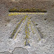
The term bench mark, or benchmark, originates from the chiseled horizontal marks that surveyor
Surveying
See Also: Public Land Survey SystemSurveying or land surveying is the technique, profession, and science of accurately determining the terrestrial or three-dimensional position of points and the distances and angles between them...
s made in stone structures, into which an angle-iron could be placed to form a "bench" for a leveling rod, thus ensuring that a leveling rod could be accurately repositioned in the same place in the future. These marks were usually indicated with a chiseled arrow below the horizontal line.
The term is generally applied to any item used to mark a point as an elevation reference. Frequently, bronze or aluminum disks are set in stone or concrete, or on rods driven deeply into the earth to provide a stable elevation point.
The height of a benchmark is calculated relative to the heights of nearby benchmarks in a network extending from a fundamental benchmark, a point with a precisely known relationship to the level datum of the area, typically mean sea level. The position and height of each benchmark is shown on large-scale maps.
The terms "height" and "elevation" are often used interchangeably, but in many jurisdictions they have specific meanings; "height" commonly refers to a local or relative difference in the vertical (such as the height of a building), whereas "elevation" refers to the difference from a nominated reference surface (such as sea-level, or a mathematical/geodetic concept near sea level known as the geoid
Geoid
The geoid is that equipotential surface which would coincide exactly with the mean ocean surface of the Earth, if the oceans were in equilibrium, at rest , and extended through the continents . According to C.F...
). Elevation may be specified as normal height
Normal height
Normal heights are heights above sea level, one of several types of height which are all computed slightly differently. Alternatives are: orthometric heights and dynamic heights....
(above a reference ellipsoid), orthometric height
Orthometric height
The orthometric height is the distance H along a line of force from a given point P at the physical surface of an object to the geoid.Orthometric heights are what are usually used in the US for ordinary engineering work. Values for measured points can be obtained from the National Geodetic Survey...
, or dynamic height
Dynamic height
Dynamic height is a way of specifying the height of a point above a reference, as opposed to orthometric height or normal height.Dynamic height is constant if one follows the same gravity potential as they move from place to place. Because of variations in gravity, surfaces having a constant...
which have slightly different definitions.
Other types of survey marks
Triangulation
In trigonometry and geometry, triangulation is the process of determining the location of a point by measuring angles to it from known points at either end of a fixed baseline, rather than measuring distances to the point directly...
points, also known as trig point
Trig point
A triangulation station, also known as a triangulation pillar, trigonometrical station, trigonometrical point, trig station, trig beacon or trig point, and sometimes informally as a trig, is a fixed surveying station, used in geodetic surveying and other surveying projects in its vicinity...
s, are marks with a precisely established horizontal position. These points may be marked by disks similar to benchmark disks, but set horizontally, and are also sometimes used as elevation benchmarks. Prominent features on buildings such as the tip of a church spire
Spire
A spire is a tapering conical or pyramidal structure on the top of a building, particularly a church tower. Etymologically, the word is derived from the Old English word spir, meaning a sprout, shoot, or stalk of grass....
or a chimney stack are also used as reference points for triangulation. In the United Kingdom
United Kingdom
The United Kingdom of Great Britain and Northern IrelandIn the United Kingdom and Dependencies, other languages have been officially recognised as legitimate autochthonous languages under the European Charter for Regional or Minority Languages...
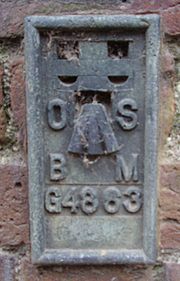
, triangulation points are often set in large concrete markers, which as well as functioning as a triangulation point, have a benchmark set into the side. With the increasing use of GPS and electronic distance measuring devices, the same techniques and equipment are used to fix the horizontal and vertical position of a survey marker at the same moment, and therefore the marks are usually regarded as "fixed in three dimensions".
Agencies responsible for benchmarks
Benchmarks are typically placed ("monumented") by a government agency or private survey firm, and many governments maintain a register of these marks so that the records are available to all. These records are usually in the form of a geographically searchable database (computer or map-based), with links to sketches, diagrams, photos of the marks, and any other technical details.Government agencies that place and maintain records of benchmarks include:
- CanadaCanadaCanada is a North American country consisting of ten provinces and three territories. Located in the northern part of the continent, it extends from the Atlantic Ocean in the east to the Pacific Ocean in the west, and northward into the Arctic Ocean...
- Natural Resources CanadaNatural Resources CanadaThe Department of Natural Resources , operating under the FIP applied title Natural Resources Canada , is the ministry of the government of Canada responsible for natural resources, energy, minerals and metals, forests, earth sciences, mapping and remote sensing...
Geodetic Survey Division (History of the Geodetic Survey Division)
- Natural Resources Canada
- FranceFranceThe French Republic , The French Republic , The French Republic , (commonly known as France , is a unitary semi-presidential republic in Western Europe with several overseas territories and islands located on other continents and in the Indian, Pacific, and Atlantic oceans. Metropolitan France...
- Institut Géographique National (IGN on Wiki FR)
- ItalyItalyItaly , officially the Italian Republic languages]] under the European Charter for Regional or Minority Languages. In each of these, Italy's official name is as follows:;;;;;;;;), is a unitary parliamentary republic in South-Central Europe. To the north it borders France, Switzerland, Austria and...
- JapanJapanJapan is an island nation in East Asia. Located in the Pacific Ocean, it lies to the east of the Sea of Japan, China, North Korea, South Korea and Russia, stretching from the Sea of Okhotsk in the north to the East China Sea and Taiwan in the south...
- Geographical Survey Institute (GSI)
- New ZealandNew ZealandNew Zealand is an island country in the south-western Pacific Ocean comprising two main landmasses and numerous smaller islands. The country is situated some east of Australia across the Tasman Sea, and roughly south of the Pacific island nations of New Caledonia, Fiji, and Tonga...
- Land Information New ZealandLand Information New ZealandLand Information New Zealand is a New Zealand government agency. The current Chief Executive is Colin MacDonald and the current Minister of Land Information is Maurice Williamson.- Nature and scope of functions :...
- Land Information New Zealand
- SpainSpainSpain , officially the Kingdom of Spain languages]] under the European Charter for Regional or Minority Languages. In each of these, Spain's official name is as follows:;;;;;;), is a country and member state of the European Union located in southwestern Europe on the Iberian Peninsula...
- Instituto Geográfico Nacional (IGN)Instituto Geográfico Nacional (Spain)The Instituto Geográfico Nacional , or National Geographic Institute is a Spanish government agency, dependent on the Spanish Ministry of Public Works...
- Instituto Geográfico Nacional (IGN)
- United KingdomUnited KingdomThe United Kingdom of Great Britain and Northern IrelandIn the United Kingdom and Dependencies, other languages have been officially recognised as legitimate autochthonous languages under the European Charter for Regional or Minority Languages...
- Ordnance SurveyOrdnance SurveyOrdnance Survey , an executive agency and non-ministerial government department of the Government of the United Kingdom, is the national mapping agency for Great Britain, producing maps of Great Britain , and one of the world's largest producers of maps.The name reflects its creation together with...
- Ordnance Survey
- United StatesUnited StatesThe United States of America is a federal constitutional republic comprising fifty states and a federal district...
- The National Geodetic SurveyU.S. National Geodetic SurveyNational Geodetic Survey, formerly called the U.S. Coast and Geodetic Survey , is a United States federal agency that defines and manages a national coordinate system, providing the foundation for transportation and communication; mapping and charting; and a large number of applications of science...
(NGS; formerly U.S. Coast & Geodetic Survey) - The United States Geological SurveyUnited States Geological SurveyThe United States Geological Survey is a scientific agency of the United States government. The scientists of the USGS study the landscape of the United States, its natural resources, and the natural hazards that threaten it. The organization has four major science disciplines, concerning biology,...
(USGS) - The United States Army Corps of EngineersUnited States Army Corps of EngineersThe United States Army Corps of Engineers is a federal agency and a major Army command made up of some 38,000 civilian and military personnel, making it the world's largest public engineering, design and construction management agency...
(USACE)
- The National Geodetic Survey
See also
- BenchmarkingBenchmarking (geolocating)Benchmarking is an activity in which individuals or teams of participants go out and find benchmarks . They typically then log their finds online...
—a recreational activity in which participants search for benchmarks using a handheld GPSGlobal Positioning SystemThe Global Positioning System is a space-based global navigation satellite system that provides location and time information in all weather, anywhere on or near the Earth, where there is an unobstructed line of sight to four or more GPS satellites...
receiver. - GeoidGeoidThe geoid is that equipotential surface which would coincide exactly with the mean ocean surface of the Earth, if the oceans were in equilibrium, at rest , and extended through the continents . According to C.F...