

Catskill High Peaks
Encyclopedia
Mountain
Image:Himalaya_annotated.jpg|thumb|right|The Himalayan mountain range with Mount Everestrect 58 14 160 49 Chomo Lonzorect 200 28 335 52 Makalurect 378 24 566 45 Mount Everestrect 188 581 920 656 Tibetan Plateaurect 250 406 340 427 Rong River...
s in New York
New York
New York is a state in the Northeastern region of the United States. It is the nation's third most populous state. New York is bordered by New Jersey and Pennsylvania to the south, and by Connecticut, Massachusetts and Vermont to the east...
's Catskill Mountains
Catskill Mountains
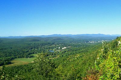
The Catskill Mountains, an area in New York State northwest of New York City and southwest of Albany, are a mature dissected plateau, an uplifted region that was subsequently eroded into sharp relief. They are an eastward continuation, and the highest representation, of the Allegheny Plateau...
above 3,500 ft (1,067 m) in elevation whose summits are separated either by one-half mile (805 m) or a vertical drop of at least 250 ft (76 m) between it and the next nearest separate summit. By usual standards, these mountains are rather low and rounded, and mostly covered by vegetation.
Unlike the Adirondack High Peaks, those in the Catskills are more evenly distributed around the eastern half of the range instead of being confined to one small area. All except Bearpen and Vly lie within the Catskill Park Blue Line
Blue Line (New York State)
The Blue Line is the term used in New York state for the boundaries of the Adirondack and Catskill parks, within which can be found the state's Forest Preserve...
.
Mohonk Mountain House
The Mohonk Mountain House also known as Lake Mohonk Mountain House, is a historic American resort hotel located on the Shawangunk Ridge in Ulster County, New York. Its prominent location in the town of New Paltz is just beyond the southern border of the Catskill Mountains on the western side of the...
and his fellow birders
Birdwatching
Birdwatching or birding is the observation of birds as a recreational activity. It can be done with the naked eye, through a visual enhancement device like binoculars and telescopes, or by listening for bird sounds. Birding often involves a significant auditory component, as many bird species are...
were trying to find the elusive Bicknell's Thrush
Bicknell's Thrush
The Bicknell's Thrush, Catharus bicknelli, is a medium-sized thrush, at 17.5 cm and 28 g . It was named after Eugene Bicknell, an American amateur ornithologist, who discovered the species on Slide Mountain in the Catskills in the late 19th century.Adults are olive-brown on the upperparts,...
, which prefers to nest and breed in the boreal forests that predominate above that elevation in the Catskills. They drew up a list nearly identical to the one below and published it in a naturalists' journal.
A decade later hikers interested in peak bagging
Peak bagging
Peak bagging is an activity in which hillwalkers and mountaineers attempt to reach the summit of some collection of peaks, usually those above some height in a particular region, or having a particular feature.Peak bagging can be distinguished from highpointing...
formed the Catskill Mountain 3500 Club
Catskill Mountain 3500 Club
The Catskill Mountain 3500 Club, incorporated as the Catskill 3500 Club and often just referred to as the 3500 Club, is a peakbagging organization for hikers in the Catskill Mountains of New York...
, an organization similar to the better-known Adirondack 46ers, to promote the climbing of 34 of the 35 peaks listed below ("Southwest Hunter" was added to the list in 1992). The club implemented the peak-separation rule, modeled on the one already in use by the Appalachian Mountain Club
Appalachian Mountain Club
The Appalachian Mountain Club is one of the United States' oldest outdoor groups. Created in 1876 to explore and preserve the White Mountains in New Hampshire, it has expanded throughout the northeastern U.S., with 12 chapters stretching from Maine to Washington, D.C...
. Prospective members are required to climb all (13 have no established route to the summit, requiring a bushwhack) and then do Slide, Blackhead, Balsam and Panther mountains again in wintertime.
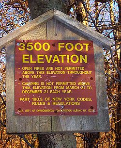
Today New York State’s Department of Environmental Conservation
New York State Department of Environmental Conservation
The New York State Department of Environmental Conservation is responsible for the conservation, improvement, and protection of natural resources within the U.S. state of New York. It was founded in 1970, replacing the previous Conservation Department...
enforces special rules for all the lands it manages in the Catskills above 3,500 feet (1,067 m), whether tiny plots such as on Rocky or vast ridgetops as on Plateau, Hunter and West Kill, due to the fragility of the ecosystems. In these areas, camping
Camping
Camping is an outdoor recreational activity. The participants leave urban areas, their home region, or civilization and enjoy nature while spending one or several nights outdoors, usually at a campsite. Camping may involve the use of a tent, caravan, motorhome, cabin, a primitive structure, or no...
is permitted only in dire emergencies except during winter, when snow shields the earth somewhat, and open fires are banned. Almost all were designated Bird Conservation Areas by Gov. George Pataki
George Pataki
George Elmer Pataki is an American politician who was the 53rd Governor of New York. A member of the Republican Party, Pataki served three consecutive four-year terms from January 1, 1995 until December 31, 2006.- Early life :...
in 1999, due to Bicknell's and other vulnerable species that return there in springtime to nest and breed.
Survey
Geophysical survey
Geophysical survey is the systematic collection of geophysical data for spatial studies. Geophysical surveys may use a great variety of sensing instruments, and data may be collected from above or below the Earth's surface or from aerial or marine platforms. Geophysical surveys have many...
s of the Catskills date to the 1940s at the newest, and exact elevations have never been officially determined for many of these peaks. In those cases, their elevations are indicated by the highest 20 foot (6 m) contour shown on the United States Geological Survey
United States Geological Survey
The United States Geological Survey is a scientific agency of the United States government. The scientists of the USGS study the landscape of the United States, its natural resources, and the natural hazards that threaten it. The organization has four major science disciplines, concerning biology,...
(USGS) quadrangle
Topographic map
A topographic map is a type of map characterized by large-scale detail and quantitative representation of relief, usually using contour lines in modern mapping, but historically using a variety of methods. Traditional definitions require a topographic map to show both natural and man-made features...
s with a plus (+) sign.
The high peaks
| Peak Name | Alt. Feet | Alt. Meters | Comments |
|---|---|---|---|
| Slide Mountain Slide Mountain (New York) Slide Mountain is the highest peak in the Catskills. It is located in the Town of Shandaken in Ulster County, in southern New York. While the contour line on topographic maps is generally accepted as its height, the exact elevation of the summit has never been officially determined by the U.S... |
4180 + | 1274 | |
| Hunter Mountain Hunter Mountain (New York) Hunter Mountain is in the towns of Hunter and Lexington, just south of the village of Hunter, in Greene County, New York, USA. At approximately 4,040 feet in elevation, it is the highest peak in the county and the second-highest peak in the Catskill Mountains.While the mountain is closely... |
4040 + | 1231 | |
| Black Dome Black Dome (New York) Black Dome is a mountain located in Greene County, New York.The mountain is the highest peak of the Blackhead Mountains range of the Catskills.Black Dome is flanked to the east by Blackhead, and to the west by Thomas Cole Mountain.... |
3980 + | 1213 | |
| Thomas Cole Thomas Cole Mountain Thomas Cole Mountain is a mountain located in Greene County, New York.The mountain named for Thomas Cole , an artist who lived in the area, and is regarded as the founder of the Hudson River School.... |
3940 + | 1201 | named after painter Thomas Cole Thomas Cole Thomas Cole was an English-born American artist. He is regarded as the founder of the Hudson River School, an American art movement that flourished in the mid-19th century... . |
| Blackhead | 3940 + | 1201 | |
| West Kill West Kill Mountain West Kill Mountain, or Westkill Mountain, is located in Greene County, New York.The mountain is named after the West Kill stream which flows along its northern side, and is part of the Devil's Path range of the Catskill Mountains.... |
3880 + | 1183 | |
| Graham Mountain | 3868 | 1179 | |
| Doubletop Mountain | 3860 + | 1177 | |
| Cornell Mountain | 3860 + | 1177 | |
| Table Mountain | 3847 | 1173 | |
| Peekamoose Mountain Peekamoose Mountain Peekamoose Mountain is a mountain located in Ulster County, New York.The mountain is part of the Catskill Mountains.Peekamoose Mountain is flanked to the north by Table Mountain.... |
3843 | 1171 | |
| Plateau Mountain | 3840 + | 1170 | |
| Sugarloaf Mountain | 3800 + | 1158 | |
| Wittenberg Mountain | 3780 + | 1152 | |
| "Southwest Hunter" | 3740 + | 1140 | unofficial name [1] |
| Balsam Lake Mountain Balsam Lake Mountain Balsam Lake Mountain is one of the Catskill Mountains, located in the Town of Hardenburgh, New York, United States. It is the westernmost of the range's 35 High Peaks... |
3723 | 1135 | |
| Lone Mountain | 3721 | 1134 | |
| Panther Mountain Panther Mountain (New York) Panther Mountain is one of the Catskill High Peaks, located in the Town of Shandaken in Ulster County, New York. At approximately 3,720 feet in elevation, it is the 18th highest in the range... |
3720 + | 1134 | |
| Big Indian Mountain Big Indian Mountain (New York) Big Indian Mountain is a mountain located in Ulster County, New York.The mountain is part of the Catskill Mountains.It is flanked to the northwest by Eagle Mountain, to the southeast by Fir Mountain, and to the southwest by Doubletop Mountain.... |
3700 + | 1128 | |
| Friday Mountain Friday Mountain Friday Mountain is a mountain located in Ulster County, New York.The mountain is part of the Catskill Mountains.Friday Mountain is flanked to the north by Cornell Mountain, and to the south by Balsam Cap.... |
3694 | 1126 | |
| Rusk Mountain Rusk Mountain Rusk Mountain is a peak located in the towns of Jewett and Lexington in Greene County, New York, USA. At 3,680 feet in elevation, it is the 20th-highest peak in the Catskill Mountains and considered a member of the Catskill High Peaks... |
3680 + | 1127 | |
| Kaaterskill High Peak Kaaterskill High Peak Kaaterskill High Peak is one of the Catskill Mountains, located in the Town of Hunter in Greene County, New York, USA. It was once believed to be the highest peak in the entire range, but its summit, at 3,655 feet in elevation, places it only 23rd among the Catskill High Peaks. It is, however,... |
3655 | 1114 | |
| Twin Mountain | 3640 + | 1109 | |
| Balsam Cap | 3623 | 1104 | |
| Fir Mountain | 3620 + | 1103 | |
| North Dome | 3610 | 1100 | |
| Eagle Mountain Eagle Mountain (Ulster County, New York) Eagle Mountain is a mountain located in Ulster County, New York.The mountain is part of the Catskill Mountains.Eagle Mountain is flanked to the north by Haynes Mountain, and to the southwest by Big Indian Mountain.... |
3600 + | 1097 | |
| Balsam Mountain Balsam Mountain (Ulster County, New York) Balsam Mountain is one of the High Peaks of the Catskill Mountains in the U.S. state of New York. Its exact height has not been determined, so the highest contour line, , is usually given as its elevation. It is located in western Ulster County, on the divide between the Hudson and Delaware... |
3600 + | 1097 | |
| Bearpen Mountain | 3600 + | 1097 | shared name [2] |
| Indian Head Indian Head Mountain (New York) Indian Head Mountain is a mountain located in the southeast corner of Greene County, New York.The mountain, named for the appearance of its profile, is part of the Devil's Path range of the Catskill Mountains.... |
3573 | 1089 | |
| Sherrill Mountain | 3540 + | 1079 | |
| Halcott Mountain Halcott Mountain Halcott Mountain is one of the Catskill Mountains of the U.S. state of New York. It is mostly located in Greene County, with some of its lower slopes in Delaware and Ulster counties. Its exact summit elevation has not been officially determined, but the highest contour line on the mountain is... |
3537 | 1078 | |
| Vly Mountain | 3529 | 1076 | |
| Windham High Peak Windham High Peak Windham High Peak is a mountain located in Greene County, New York.The mountain is part of the Catskill Mountains.Windham High Peak stands within the watershed of the Hudson River, which drains into New York Bay.... |
3524 | 1074 | |
| Rocky Mountain Rocky Mountain (Ulster County, New York) Rocky Mountain is a mountain located in Ulster County, New York.The mountain is part of the Catskill Mountains.Rocky Mountain is flanked to the west by Lone Mountain, and to the northeast by Balsam Cap.... |
3508 | 1069 |
-
- [1] The name is currently unofficial. It refers to the peak that rises between Hunter and West Kill on the USGS LexingtonLexington, New YorkLexington is a town in Greene County, New York, United States. The population was 805 at the 2010 census.The Town of Lexington is in the southwest part of Greene County.- History :The town was first settled around 1788....
quad
- [1] The name is currently unofficial. It refers to the peak that rises between Hunter and West Kill on the USGS Lexington
-
- [2] This refers not to "Bearpen Mountain" shown on the USGS PrattsvillePrattsville, New YorkPrattsville is a town in Greene County, New York, United States. The Town of Prattsville is in the northwest part of the county. As of the 2010 census, the city population was 700.- History :...
quad straddling the border between DelawareDelaware County, New YorkDelaware County is a county located in the U.S. state of New York. As of 2010 the population was 47,980. The county seat is Delhi. It is named after the Delaware River, which was named in honor of Thomas West, 3rd Baron De La Warr, appointed governor of Virginia in 1609.-History:When counties...
and GreeneGreene County, New YorkGreene County is a county located in the U.S. state of New York. Its name is in honor of the American Revolutionary War general Nathanael Greene. Its county seat is Catskill...
counties at 3,520 feet (1073 m), but rather the unnamed higher area approximately one-half mile (800 m) to the southeast in Greene County.
- [2] This refers not to "Bearpen Mountain" shown on the USGS Prattsville
Potential High Peaks
Without the aforementioned "AND" ruling of the Catskill 3500 Club, the unnamed summit west of Thomas Cole (unofficially referred to as "Camel's Hump") sits within the 3520 feet (1,072.9 m) contour and is more than the required distance from that peak's summit. No one has yet considered it a High Peak, however.The inexact nature of past USGS surveys of the region have led to speculation that two 3,480-foot (1,060 m) summits in the western Catskills might prove to be High Peaks if measurements were redone with more modern technology. GPS readings on some summits have consistently suggested higher elevations than those given on the maps.
Mill Brook Ridge, the named summit of the pair, would displace neighboring Balsam Lake as the westernmost Catskill High Peak were any of the land in its summit contour found to exceed 3,500 feet. However, much of that land is as flat as the map suggests and the peak may come close to that height but not over it.
The other is "East Schoolhouse Mountain," the unofficial name for the higher of the two peaks on the ridge between Balsam Lake and neighboring Graham. Digital Elevation Modeling (DEM) data in some mapping software suggests its summit may just exceed the limit.
There is also a tiny 3500 feet (1,066.8 m) contour indicated more than a half-mile east of West Kill's summit, right next to the drop into Diamond Notch, but exploration of that area has cast doubt on whether it actually exists.