
History of the Australian Capital Territory
Encyclopedia
The history of the Australian Capital Territory
(ACT) as an administrative division of Australia
began after the Federation of Australia
in 1901, when it was created in law as the site for Canberra
, Australia's capital city. The region has a long prior history of human habitation before the Territory's creation, with evidence of Indigenous Australian
settlement dating back at least 21,000 years. The area formed the traditional lands associated with the Ngambri People and several other linguistic groups
, an association known through both early European settler accounts and the oral histories
of the peoples themselves.
Following the colonisation of Australia by the British, the 19th century saw the initial European exploration and settlement of the area and their encounters with the local indigenous peoples, beginning with the first explorations in 1820 and shortly followed by the first European settlements in 1824. At the outset the region was dominated by large properties used for sheep and cattle grazing, which had been granted to free settlers that had arrived in Australia from the United Kingdom and other European countries. These large properties were later broken up and subdivided in accordance with changes to land tenure
arrangements, smaller farms and urban developments becoming more common.
In 1908, the region was selected as the site of the nation's future capital city. In 1909, New South Wales
formally ceded to the federal government
the territory and additional land at Jervis Bay
for the establishment of a sea port for the capital. The territory officially came under government control as the Federal Capital Territory on 1911. The planning and construction of Canberra followed, with the Parliament of Australia
moving there in 1927.
The Territory officially became the Australian Capital Territory in 1938. Canberra was built to accommodate the government, while the surrounding area was developed to support the city, including the construction of dams, the establishment of plantation forests and the creation of protected areas
. An advisory council was established in 1930, with some elected representation.
Initially, the growth of Canberra and the ACT was slow. The American architect Walter Burley Griffin
won the competition to design Australia's new capital and was appointed to oversee its construction. He was frequently dogged by disputes with Australian authorities and the onset of World War I
, which hindered progress. In 1921, Burley Griffin was fired, and multiple planning bodies were established, but achieved little, in part due to the Great Depression
.
In the period after World War II
, Prime Minister
Robert Menzies
regarded the state of Canberra as an embarrassment, and took it upon himself to champion its development. Under his leadership —which lasted more than a decade— the development of the capital was rapid. The National Capital Development Commission
was created in 1957 with more power than its predecessors, and ended four decades of disputes over the shape and design of Lake Burley Griffin
, the centrepiece of Canberra, and construction was completed in 1964 after four years of work.
This prompted the development of the Parliamentary Triangle
, a core part of Griffin's design, and since then various buildings of national importance were constructed on the lakefront. The Australian National University
was built, and sculptures and monuments were built. On average, the population of Canberra increased by more than 50% every five years between 1955 and 1975 as the development of the capital became more concerted, and new residential land was released through the creation of new town centres in the 1960s and 1970s.
In 1949, the territory gained its first representative in the Parliament, although at first with limited speaking and voting rights. In 1974 it gained a fully elected, but still advisory House of Assembly
. In 1988 it gained the trappings of self-government with a Legislative Assembly
with most of the powers and responsibilities of an Australian state, although subject to a federal right of veto, similar to the arrangements adopted for the Northern Territory
in 1978. The Legislative Assembly legalised some things that were prohibited in other parts of Australia, such as prostitution and X-rated pornography; in 2006, an attempt to allow civil unions for same-sex couples was overruled by the federal government.
 Indigenous Australian peoples have long inhabited what is now the ACT. Anthropologist Norman Tindale
has suggested the principal group occupying the region were the Ngunnawal people
, while the Ngarigo
and Walgalu
lived immediately to the south, the Wandandian to the east, the Gandangara to the north, and the Wiradjuri
to the north-west.
Archæological evidence from the Birrigai rock shelter in Tidbinbilla Nature Reserve
indicates habitation dating back at least 21,000 years. It is possible that the area was inhabited for considerably longer, with evidence of an Aboriginal presence in south-western New South Wales dating back around 40,000–62,000 years. Another site of significance in the reserve is the Bogong Rocks shelter, which contains the oldest evidence of Aboriginal occupation at a bogong moth
resting site. These insects were an important source of food for the Aboriginal peoples of the Southern Alps
and would accumulate by the thousands in caves and rock crevices, where they were collected and later roasted in sand or ashes, and then eaten whole.
Numerous other culturally significant and archæologically notable sites are known across the territory, including shelters, rock art sites, stone artefact scatters, scarred trees
and chert
quarries. Tidbinbilla Mountain is believed to have long been used for Aboriginal initiation ceremonies.
. Governor Lachlan Macquarie
supported expeditions to open up new lands to the south of the capital Sydney
, including one to find an overland route to Jervis Bay
, an area which would later be incorporated into the ACT as its only coastal possession. In 1818 Charles Throsby
, Hamilton Hume
, James Meehan
and William Kearns set out to find the route, a task accomplished that same year by Throsby and Kearns.
The 1820s saw further exploration in the Canberra area associated with the construction of a road from Sydney to the Goulburn
plains, supervised by Throsby and his overseer, Joseph Wild
. While working on the project, Throsby learned of a nearby lake and river from the local Aborigines, and he accordingly sent Wild to lead a small party to investigate the site. On 1820, Wild ventured off from his two companions, and later that day arrived at the north shore of what is now known as Lake George
. In Governor Macquarie visited the site, and while he was in attendance Throsby decided to push on to reach the river that he had been informed of. Accompanied by Wild and James Vaughan, he journeyed south in search of the Murrumbidgee
. The search was unsuccessful, but they did discover the Yass River
, and it is surmised that they would have set foot on part of the future ACT.
A second expedition was mounted shortly thereafter, and Throsby's nephew Charles Throsby Smith, Wild and Vaughan further explored the Molonglo
(Ngambri) and Queanbeyan
(Jullergung) Rivers, becoming the first Europeans to camp at the site. However, they failed to find the Murrumbidgee, and Smith declared that the river did not exist. The issue of the Murrumbidgee was solved in 1821, when Charles Throsby mounted a third expedition and successfully reached the watercourse, on the way providing the first detailed account of the land where Canberra now resides.
The next significant expedition to the region came in 1823, when Wild was employed by Brigade Major John Ovens and Captain Mark Currie to guide them to the Murrumbidgee. They travelled south along the river and named the area now known as Tuggeranong Isabella's Plain, after Isabella Maria Brisbane (1821–1849), the two-year-old daughter of Thomas Brisbane
, the then Governor of New South Wales. Unable to cross the river near the current site of Tharwa
, they continued on to the Monaro Plains. The last expedition in the region prior to settlement was undertaken by Allan Cunningham
in 1824. He reported that the region was suitable for grazing, and the settlement of the Limestone Plains followed immediately thereafter.
 When the boundaries for settlement
of New South Wales
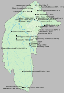
were determined, the Limestone Plains were opened up to settlers. The first land grant in the region was made to Joshua John Moore in 1823, and settlement in the area began in 1824 with the construction of a homestead by his stockmen on what is now the Acton Peninsula
. Moore formally purchased the site in 1826 and named the property Canberry, or Canberra, although he never visited it. His 4 km² (1.5 sq mi) claim covered much of the future North Canberra
.
Adjacent to the eastern boundary on Moore's claim was the settlement of Duntroon
, occupied by James Ainslie
on behalf of Robert Campbell. John Palmer was granted land in the region, which was taken up by his son George in 1826. He established Palmerville near Ginninderra Creek
in 1829, and the "Squire" at Gungahlin
was completed in 1861. Palmerville in the Ginninderra
district was the site of first school in the region, and operated from 1844 to 1848. The first school in the future Canberra opened on the Duntroon Estate, next door to St John's Church
in what would become the suburb of Reid in the 20th century. Canberra's first church, St John's, was consecrated and opened for use in 1845.
The Tuggeranong
Plains, situated 10 km (6.2 mi) south of the Molonglo River, were first settled in 1827 by Peter Murdoch. The Waniassa Homestead (also known as Tuggeranong Homestead) was established in 1836 by John McQuoid, and the first buildings of the Lanyon estate, owned by John Lanyon and James Wright, were built in 1838. Tharwa
was settled in 1834; the homestead in this area was Cuppacumbalong
, established by James Wright in 1839. Tharwa is the oldest official settlement in the ACT, having being proclaimed in 1862.
Settlers moved further south into what is now the Namadgi National Park
. William Herbert made a claim over part of the Orroral Valley at some point between 1826 and 1836, while during the 1830s Garrett Cotter
inhabited what would later be named the Cotter River
Valley, in his honour. From the late 1830s, the Boboyan Homestead and station were established. Gudgenby was settled in the early 1840s and the Gudgenby Homestead was erected around this time. By 1848 most of the major valleys of the Namadgi area had been settled.
Convict labour was widely used in the region, and the first bushranger
s in the area were runaway convicts. John Tennant, the earliest and best-known bushranger of the region, lived in a hideout on what is now known as Mount Tennant, behind Tharwa. From 1827 he raided the local homesteads, stealing stock, food and possessions until his arrest in 1828; He was later hung in Sydney for his crimes. The lawlessness of the region led to the appointment of the first resident magistrate on 1837 – Allured Tasker Faunce, who was also known as "Ironman Faunce" since his time as a magistrate at Brisbane Water
. The magistrate oversaw legal matters and issued liquor licenses to several establishments, the first being the Elmsall Inn on the Duntroon estate in 1841.
A significant influx of population and economic activity occurred around the 1850s goldrushes
, particularly the Kiandra rush of 1859–60. The goldrushes prompted the establishment of communication between Sydney and the region by way of the Cobb & Co
coaches, which transported mail and passengers. The first post offices opened in Ginninderra in 1859 and at Lanyon the following year. Bushranger activity continued with the goldrushes: Australian-born bandits Ben Hall and the Clarke brothers
were active in the area, targeting mail coach
es and gold transportation.
Terence Aubrey Murray was born in Ireland in 1810 and came to Sydney with his father, a retired redcoat army officer, and siblings in 1827. In 1837, he acquired the Yarralumla
sheep station, taking up residence in Yarralumla's Georgian-style homestead, which he extended. He was elected unopposed to represent the surrounding Counties of Murray
, King
and Georgiana
in the first partially elective Legislative Council
in 1843. With the establishment of responsible government
in 1856, Murray became a member of the first Legislative Assembly
, representing the electorate of Southern Boroughs
– which included nearby Queanbeyan
– and in 1859 he was elected to represent Argyle
– which included another of his pastoral properties, Winderradeen, in the Collector
area, north of Canberra.
The Robertson Land Acts
and the Closer Settlement Acts
altered the mechanism for granting land tenure
and precipitated the break-up of large properties in New South Wales. During the 1860s, in the wake of the new government legislation, small farmers nicknamed "selectors" moved into what would become the ACT, taking up parcels of (usually inferior) land which existed between the estates of the wealthy, established landholders.
During colonial times, prior to the establishment of the ACT, the European communities of Ginninderra, Molonglo
and Tuggeranong settled in and farmed the surrounding land, raising sheep in the main but also breeding horses and growing grain. The region was also called the Queanbeyan/Yass
district, after the two largest towns in the area. The villages of Ginninderra and Tharwa developed to service the local agrarian communities. In 1882, the first allotments in the village of Hall – named after early pastoralist Henry Hall – were sold. By 1901, it was an established town with a hotel, coachbuilder, blacksmith, butcher, shoemaker, saddler, dairy and two stores.
In 1886, the agronomist William Farrer
, established the research farm 'Lambrigg' on the banks of the Murrumbidgee south of present-day Tuggeranong. Farrer experimented with rust and drought-resistant wheat; the varieties he bred were widely used by Australian growers, and he was later credited with establishing Australia as a major producer. Tharwa Bridge, the oldest surviving bridge in the region, was opened in 1895 and was the first crossing over the Murrumbidgee River. By 1911, when the region came under federal control, the population had grown to 1,714 settlers.
in 1849 and attempted to set up a cattle farm. His livestock was slaughtered by the local Aborigines and he was driven back out of the mountains. The rush of prospectors into the Kiandra area through the Brindabellas and the mountains to the west of the ACT as a result of the Kiandra goldrush led to conflict with the Aboriginal people. By the time Franklin returned to the Brindabellas in 1863, the indigenous population had been significantly reduced.
Over the succeeding years, the Ngunnawal and other local Indigenous people effectively ceased to exist as cohesive and independent communities adhering to their traditional ways of life. Those who had not succumbed to disease and other predations either dispersed to the local settlements or were relocated to more distant Aboriginal reserves set up by the NSW government in the latter part of the 19th century. The children of mixed European-Aboriginal families were generally expected to assimilate into the settlement communities. The Ngunnawal people were subsequently often considered to be "extinct"; however, in a situation parallel to that of the Tasmanian Aborigines
, people with claims to Ngunnawal ancestry continue to identify themselves as such. However, there have been contemporary instances of dispute within the community itself over who is properly considered to be a member of the Ngunnawal people.
during the 19th century. Prior to 1840 Sydney
was the administrative centre for the colony, and thus it could be presupposed that any potential federal government would be seated there. However, this started to change when, buoyed by the Victorian Gold Rush
, Melbourne
grew rapidly, and by 1860 its population had overtaken that of Sydney. The discovery of gold also helped to increase Melbourne's financial base, to the point where at one stage "nearly 5% of all British imperial government revenue ... passed through [Melbourne's] port". Thus Melbourne soon possessed both the size and the economic clout to rival Sydney and to command additional administrative powers.
 When federation was first being discussed, views differed about the location of the capital. Early advocate for Australian federation, John Dunmore Lang
, backed Sydney, but Henry Parkes
, a prominent New South Wales politician and Premier, proposed the capital be founded on "neutral ground", nominating the town of Albury
as a location. (Albury was located in New South Wales, yet its position on the Murray River
placed it on the border between New South Wales and Victoria).
In 1898, a referendum on a proposed Constitution was held in four of the colonies – New South Wales, Victoria, South Australia
and Tasmania
. Although the referendum achieved a majority in all four colonies, the New South Wales referendum failed to gain the minimum number of votes needed for the bill to pass. Following this result, a meeting of the four Premiers in 1898 heard from George Reid
, the Premier of New South Wales, who argued that locating the future capital in New South Wales would be sufficient to ensure the passage of the Bill. This was accepted by the other three Premiers, and the proposed Australian Constitution
was modified so that Section 125 specified that the national capital must be "within the state of New South Wales". However, they also added the condition that it must be situated no less than 100 mi (160.9 km) from Sydney. In addition, if the bill passed, Melbourne would be the interim seat of government (but not referred to as the "capital") until a location for the new capital had been determined. The 1899 referendum on this revised bill was successful, passing with sufficient numbers.
 Nevertheless, this left open the question of where to locate the capital. Initially the Bombala
district in the far south of NSW was proposed, to which southern Monaro, (which incorporated Bombala), Orange
and Yass
were soon added. The NSW Premier, John See
, offered to provide any of the three recommended sites as a future capital territory. Edmund Barton
, the first Prime Minister
of the new Federal government, added another four sites to this list: Albury, Tamworth
, Armidale
and Tumut
, and members of the new government toured the various sites in 1902. The tour proved inconclusive, and upon their return the members decided to refer the problem to a Royal Commission
, with the Minister for Home Affairs, William Lyne
, pushing for Tumut or Albury as he preferred a site in his electorate. Subsequently, the Commission presented its report to parliament in 1903, recommending the sites of Albury
, Tumut
and Orange
, in that order. However, there continued to be problems, as the House of Representatives backed the Tumut option, while the Senate preferred the town of Bombala. As a result of this disagreement the bill lapsed, and it was left to the second Parliament to choose a location for the capital.
The new Parliament met in 1904 and reached a compromise, choosing Dalgety
, which, like Bombala, was located in the Monaro region. Thus, with the passage of the Seat of Government Act 1904
, it appeared that the matter had been settled. However, while the Federal Parliament supported Dalgety, the New South Wales government did not, and they proved unwilling to cede the amount of territory the federal government demanded.
 Finally, in 1906, New South Wales agreed to cede sufficient land, but on the condition that it was in the Yass
-Canberra
region, this site being closer to Sydney. Following a tour of the region by several Senators and Members of the Commonwealth Parliament, in 1908 a new ballot was called in the Federal Parliament with eleven sites nominated. Initially, Dalgety remained at the forefront, but by the eighth round Yass-Canberra had emerged as a new leader, and the site was confirmed in the ninth round of voting. Thus was passed the new Seat of Government Act 1908
, which repealed the 1904 Act and specified a capital in the Yass-Canberra region.
Government Surveyor Charles Scrivener
was deployed to the region in the same year in order to map out a specific site and, after an extensive search, settled upon the present location, about 300 km (186.4 mi) south-west of Sydney in the foothills of the Australian Alps.
 In 1909, New South Wales transferred the land for the creation of the Federal Capital Territory to federal control though two pieces of legislation, the Seat of Government Acceptance Act 1909
and the Seat of Government Surrender Act 1909
. The Act transferred Crown land
in the counties of Murray
and Cowley
to the Commonwealth, which amounted to an area about 2330 square kilometres (899.6 sq mi) and eight parcels of land near Jervis Bay
. All private land in the surrendered area had to be bought by the Commonwealth. The Seat of Government Acceptance Act also gave the Commonwealth rights to use and control the waters of the Queanbeyan and Molonglo River
s.
In 1910, the Seat of Government (Administration) Act 1910
created the legal framework for the Territory. The act specified that laws in the Territory could be made by the Commonwealth and that Ordinances could be made by the Governor-General, and placed the ACT under the jurisdiction of the New South Wales Supreme Court
. When the Act came into force on 1911, control of the Territory was officially assumed by the Commonwealth. This Act remained the constitutional basis for law-making in the ACT until the granting of self-government in 1989.
The Minister for Home Affairs
, King O'Malley
, who was responsible for the legislation creating the ACT, also introduced a bill in 1910 making the ACT an alcohol-free area; this bill was passed by the Federal parliament and the law was not repealed until 1928. Until that time local residents travelled to Queanbeyan
, just across the New South Wales border, to drink on Saturday. In 1938 the Territory was formally renamed the Australian Capital Territory.
The Jervis Bay Territory Acceptance Act 1915
and the New South Wales Seat of Government Surrender Act 1915
created a Territory of Jervis Bay
, which was administered as part of the Federal Capital Territory and with all laws of the Territory applicable.
Such was not the case. Legislation restricted land holdings in the new territory to leasehold, rather than freehold. This was intended to avoid land speculation and give the national government, as the lessor, greater control over development. Landowners were concerned that the legislation had a number of shortcomings: land valuations were fixed to the date when the Act passed ( 1908), there was no compensation for improvements made to the land, and owners were not given first right of refusal when their old land was offered for lease.
Along with the loss of their land, local residents discovered that they had been disenfranchised. Now a part of the ACT, they had lost their vote in the New South Wales government, and their numbers were too small to warrant a seat in the new federal parliament. As a result they had no representation in parliament through which to argue against the provisions of the legislation.
In response the residents formed the Vigilance Association with the intent of protecting their interests during the establishment of the new capital territory. Legal challenges to the resumption of the land were unsuccessful, but the Vigilance Association did win some concessions: the government agreed to pay for the improvements to the land, and did so at the value when the land was acquired; and the landowners gained the right of first refusal on their old properties when they were put up for lease. As of 2010 all residential land in the ACT is held on a 99-year crown lease.
One of the first federal facilities established in the Territory was the Royal Military College
, established on the Campbells' property Duntroon
, which opened in 1911. Prior to this, Australia's military lacked formally trained officers, who were needed due to changes to the Australian military model that had emerged after Federation.
In the same year, an international competition to design the future capital was held, which was won by the Chicago architect Walter Burley Griffin
in 1912. Griffin's proposal, rendered by his architect wife Marion Mahony Griffin
, had an abundance of geometric patterns, incorporated concentric hexagonal and octagonal streets emanating from several centres. It had as its centrepiece an elaborate lake composed of smaller bodies of water, with extensive natural vegetation around it. Griffin's proposal was "the grandest scheme submitted, yet it had an appealing simplicity and clarity". The lakes and geometry were deliberately designed so that their orientation was related to various natural topographical landmarks. It was further intended that buildings of national significance and natural landmarks would align with these geometric axes. Later, Scrivener, as part of a government committee, was responsible for modifying Griffin's winning design. He recommended a less elaborate and geometric shape, which Griffin opposed, saying that geometry was "one of the raison d'etre of the ornamental waters", but he was overruled. The new design was widely criticised as being ugly.
The official naming of Canberra occurred on 1913, and construction began immediately. After official indecision over the plan, revisions and their implementation, Griffin was invited to Canberra to discuss the matter. He arrived in and was appointed Federal Capital Director of Design and Construction for three years. Bureaucratic wrangling delayed Griffin's work; a Royal Commission in 1916 ruled his authority for executing the plan had been usurped by certain officials. Griffin had a strained working relationship with the Australian authorities, and a lack of federal government funding meant that by the time he left in 1920, little significant work had been done on the city. Prime Minister Billy Hughes
removed Griffin from his position. At the time of his removal, Griffin had revised his plan, overseen the earthworks of the major avenues, and established the Glenloch Cork Plantation.
 After Griffin's departure, the Federal Capital Advisory Committee
was established to advise the government of the construction efforts. The Committee had limited success meeting its goals; however, the chairman, John Sulman
, was instrumental in applying the ideas of the garden city movement
to Griffin's plan. The Committee was replaced in 1925 by the Federal Capital Commission
. The role of the FCC was to prepare Canberra for the transfer of the Commonwealth Parliament and the public service from Melbourne to Canberra. The Federal Government officially relocated to the ACT from Melbourne on the formal opening of the Provisional Parliament House
on 1927. Among the new Parliament's first acts was the repeal of the prohibition laws. At first the public service remained based in Melbourne, the various departments' headquarters only gradually moving to Canberra over the space of several years. From 1938 to 1957 the National Capital Planning and Development Committee
continued to plan the further expansion of Canberra; however, the NCPDC did not have executive power, and decisions were made on the development of Canberra without the Committee's consultation. A few major buildings were constructed during this period of NCPDC responsibility, such as the Australian War Memorial
, which opened in 1941. With the onset of the Great Depression
, followed by World War II, development of the new capital was slow, and in the decade after the end of the war, Canberra was criticised for resembling a village, and its disorganised collection of buildings was deemed ugly. Canberra was often derisively described as "several suburbs in search of a city". The Prime Minister, Robert Menzies
, regarded the state of the national capital as an embarrassment. Over time his attitude changed from one of contempt to that of championing its development. He fired two ministers charged with the development of the city, feeling that their performance lacked intensity. Menzies ruled for over a decade and in that time the development of the capital sped up rapidly.
 After World War II there was a shortage of housing and office space in Canberra, so a Senate Select Committee hearing was held in 1954 to address its development requirements. This Committee recommended the creation of a single planning body with executive power. Consequently, the NCPDC was replaced by the National Capital Development Commission
in 1957. The NCDC ended four decades of disputes over the shape and design of Lake Burley Griffin
, and construction was completed in 1964 after four years of work. The completion of the centrepiece of Griffin's design finally the laid the platform for the development of Griffin's Parliamentary Triangle
. In the four decades since the initial construction of the lake, various buildings of national importance were constructed on the lakefront. According to the policy plan of the government, "The lake is not only one of the centrepieces of Canberra's plan in its own right, but forms the immediate foreground of the National Parliamentary Area." The newly built Australian National University
, on the northern shores of the lake was expanded, and sculptures and monuments were built.
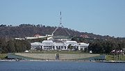
The completion of the central basin placed a waterway between Parliament House and the War Memorial and a landscaped boulevard was built along the land axis. A new National Library
was constructed within the Parliamentary Triangle, followed by the High Court of Australia
, the National Gallery
and finally a new Parliament House
in 1988. In 2001, the National Museum
was built on the former lakeside site of the Royal Canberra Hospital
.
On average, the population of Canberra increased by more than 50% every five years between 1955 and 1975 as the development of the capital became more concerted. To accommodate the influx of residents, the NCDC oversaw the release of new residential land though the creation of new town centres: Woden
opened in 1964, followed by Belconnen
in 1966, Weston Creek
in 1969 and Tuggeranong
in 1973. The NCDC was disbanded in 1988, its planning authority transferred to the newly created ACT government and the new National Capital Authority
, which was established to oversee Commonwealth interests in development of the national capital. Canberra has continued to grow with the further release of residential land in Gungahlin
in the 1990s.
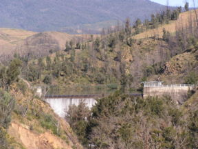 A significant priority for the establishment of Canberra was the construction of water storage facilities. Cotter Dam was the first dam built on the Cotter River
; construction on this 18.5 m (60.7 ft) concrete gravity dam started in 1912 and finished in 1915. Its height was raised to 31 m (101.7 ft) in 1951. Chlorination
of Canberra's water began at Cotter Dam in 1955; operations were moved to the Mount Stromlo Water Treatment Plant in .
Two additional dams were built on the Cotter: the Bendora Dam
, a double-curvature, concrete-arch structure, was completed in 1961; and the Corin Dam, an earth and rock-fill embankment dam, was built in 1968. In 1979 Googong Dam was built on the Queanbeyan River
in New South Wales.
Transport into and out of the ACT was an early development priority. In 1931 the Federal Highway
linking the ACT to Goulburn
was completed, and in 1936 an airfield was constructed at Duntroon. On 1940 Australia's chief military officer and three senior ministers in the Menzies Government, James Fairbairn
, Geoffrey Street
and Henry Somer Gullett, were killed when their plane crashed
on the southern approach to Canberra.
A 6.5 km (4 mi) branch from the Bombala railway line was built from Queanbeyan to Canberra station
in 1914 and extended to Civic in , but the bridge over the Molonglo River was washed away in 1922 and never rebuilt. Plans to build a railway to Yass were abandoned. A 1067 mm gauge construction railway was built in 1923 between the Yarralumla brickworks
and the provisional Parliament House. It was later extended to Civic, but the whole line was closed in . A railway connecting Canberra to Jervis Bay was planned, but never constructed. Several facilities were built in Jervis Bay including the Royal Australian Naval College (HMAS Creswell) erected in 1913, the Jervis Bay Air Base Range, and a Botanic Gardens.
The native forest of the ACT was composed almost wholly of eucalypt
species and provided a resource for fuel and domestic purposes, especially during the economic boom following World War II. By the early 1960s, logging had depleted the eucalypt, and concern about water quality in the Cotter River catchment led to the forests being closed. Interest in forestry had begun in 1915, when T. C. G. Weston
had commenced trials of a number of species including Pinus radiata
on the slopes of Mount Stromlo. Plantation forestry began in earnest in 1926 with 2 km² (0.77220431718507 sq mi) planted annually around Uriarra
and Pierce's Creek
.
By 1938 the area planted yearly was 4 km² (1.5 sq mi), with the favourable benefit of reducing erosion in the Cotter catchment. In 1967 the Australian Government approved a plan for a total 160 km² (61.8 sq mi) of plantation in the ACT, which was achieved in 1970. The ease of access to the plantations has made them popular recreation areas for Canberrans. Throughout the 20th century, significant areas of plantation forest were periodically lost to bushfires, with major fires occurring in 1939, 1952, 1979, 1983, 2001 and 2003
.
 In 1936 about 8.1 km² (3.1 sq mi) of forest was set aside to create the Tidbinbilla Nature Reserve
, and in 1939 a koala enclose was built by the Institute of Anatomy. The government acquired land to establish a national park and fauna reserve in 1962, expanding it to 36.3 km² (14 sq mi) and later, to its current size of 54.5 km² (21 sq mi). In 1969 the first wildlife displays were created, and the park was officially gazetted in 1971. In 1984 the Namadgi National Park
was declared. It is 1061 km² (409.7 sq mi) and takes up approximately 46% of the ACT's land.
In 1911, Mount Stromlo was assessed as a possible site for a Commonwealth Solar Observatory
, and it became the location of the facility in 1924. It was operated as a Commonwealth government facility until 1957, when it was transferred to the Australian National University (ANU). From 1944 to 1968 it was also the site of the national time-keeping service. By the early 1980s, Mount Stromlo, together with the ANU's Siding Spring observatory, was producing Australia's greatest astronomical research output.
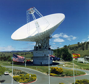
The Australian Government signed an agreement with the United States in 1960 for the establishment of satellite-tracking stations in the ACT. As a result of the agreement, three tracking stations were built in the ACT by NASA
. The Canberra Deep Space Communication Complex
was officially opened on 1965 by Prime Minister Menzies, and is the only station still in operation in the ACT, communicating with interplanetary spacecraft.
The Orroral Valley Tracking Station
, which was for orbiting satellite support, opened in in what is now part of Namadgi National Park
, was closed down in 1985. Honeysuckle Creek Tracking Station
, completed in , was a communications relay station for Project Apollo
, Skylab
and interplanetary spacecraft from 1967 until 1981, when its 26 m (85.3 ft) antenna was moved to the Canberra Deep Space Communication Complex. It was closed in and is now being dismantled.
was created in 1927, the same year the federal government moved to the ACT, with eleven officers. The size of the force grew over subsequent decades with the development of Canberra, and oversaw law and order in the territory until 1979. In that year, the ACT Police merged with the Commonwealth Police and the Federal Narcotics Bureau to form the Australian Federal Police
(AFP), which then took responsibility for law and order in Canberra. Since self-government was granted in 1988, the AFP has performed this under contract to the ACT government.
The ACT was given its first federal representation in 1949, when it gained a seat in the House of Representatives, the Division of Australian Capital Territory
, under the 1948 Representation Act which increased the size of the House of Representatives. The ACT member could only vote on matters directly affecting the Territory. In 1974, the ACT and the Northern Territory were each allocated two Senate seats. In 1974, the House of Representatives seat was divided into two, the Division of Canberra
and Division of Fraser
. A third, the Division of Namadgi
, was created in 1996, but was abolished in 1998 after an updated assessment of changes to the regional demographic distribution. Both House of Representatives seats have mostly been held by the Australian Labor Party
, while ALP and the Liberal Party of Australia
have always each held one Senate seat.
In 1930, the ACT Advisory Council was established to advise the Minister for Territories on the community's concerns and from 1934 the territory had its own Supreme Court
. In 1974 the Council became a fully elected Legislative Assembly
, advising the Minister of the Capital Territory, and in 1979 this renamed the House of Assembly.
 Although there was a push by residents of the ACT for a greater say in the management of the territory, this did not necessarily equate to a desire for self-governance. John Overall
, who served as the head of the NCDC from 1957 to 1972, summarised the distinction in "Canberra: Yesterday, Today and Tomorrow":
Nevertheless, there were many residents in Canberra who wanted self-government, and there were a number of forces pushing the territory in that direction.
The formation of the Legislative Assembly in 1974 was intended as the significant step towards self-government, but the Whitlam Government
, under whose auspices the Assembly was formed, tended to "override or ignore its wishes." Similarly, the subsequent 1975 Fraser Government
seemed uninterested in the Assembly. However, in February 1975, Tony Staley
accepted the post of Minister for the Capital Territory. Staley had been a supporter of self-government for the ACT, and he proposed a model whereby Canberrans would rapidly gain control of much of the territory's administration. The model found opposition, though, in part because it failed to adequately address the funding arrangements.
Although Staley's plan did not eventuate, the next person to run the Ministry, Robert Ellicott, chose to hold a referendum
on the issue. The 1978 referendum provided the residents of the territory with three options:
A clear majority voted for continuing with the status quo – 63.75%, as opposed to 5.72% in favour of the local government model and 30.54% supporting the "state style" self-government approach.
Overall identified a number of reasons why residents opposed self-government. Along with the previously mentioned fear of increases in taxation or decreases in services, he argued that those living in the ACT would have felt that they already had a voice in the governance of the territory, through federal electoral representation. Canberra also had a high proportion of public servants who felt that they were already a part of the government, and knew how to work with the system.
In spite of the result, the referendum failed to end the debate. There were a number of pressures that continued to push the ACT towards self-government, including:
In 1988, the new minister for the ACT, Gary Punch
, received a report recommending the abolition of the NCDC and the formation of a locally elected government. Punch recommended that the Hawke government
accept the report's recommendations, and subsequently Clyde Holding
introduced legislation to grant self-government to the Territory in October 1988.
. The first elections
were held 1989, and the inaugural 17-member Legislative Assembly
moved into former public service buildings at 1 Constitution Avenue
, Civic
on 1989. The Australian Labor Party
formed the ACT's first government, led by Chief Minister
Rosemary Follett
, who made history as Australia's first female head of government. Although since the commencement of self-government, ACT law has continued to apply in general to the Jervis Bay Territory
under section 4A of the Jervis Bay Territory Acceptance Act 1915
, the ACT as defined under the Self-Government Act 1988 does not include Jervis Bay, which continues to be administered by the Commonwealth. Since 1992, members of the Assembly have been elected by the Hare-Clark
proportional representation system from three multi-member electorates, which replaced the modified D'Hondt method
used in the inaugural election, in which the 17 representatives were elected from a territory-wide electorate.
Whereas the ACT's federal electorates have been mainly held by Labor, the Liberal Party has been able to gain some footing in the ACT Assembly, and were in government for just over eight of the Assembly's 21-year history. Most of this was during a period of six and half years from 1995 and 2001, which ended when Labor gained a 14.1% swing at the polls. In contrast to the state elections, Labor has polled at least seven percentage points more than the Liberals at every federal election since 1990, and their average lead since then has been 15 percentage points.
The initial years of self-government were difficult and unstable. A majority of ACT residents had opposed self-government and had it imposed upon them by the federal parliament, and at the first election, 4 of the 17 seats were won by anti-self-government single-issue parties due to a protest vote by disgruntled territorians, and a total of 8 were won by minor parties and independents. Follett and Labor won only four seats and had to form a minority government, as seven groups were represented in total. Some of the anti-self-government representatives sought to disrupt the territory's legislature from the inside, and a no-confidence motion toppled Labor after only seven months. Trevor Kaine
and the Liberals ruled for 18 months before being deposed, and Follett's Labor returned, the third government in 25 months. In 1992, Labor won eight seats, and the minor parties and independents won only three. Stability increased, and in 1995, Kate Carnell
became the first elected Liberal chief minister. In 1998 Carnell became the first chief minister to be re-elected. She was regarded as a proactive leader but resigned in 2000 after two independents who had supported her minority government withdrew their support. At the time, she had been embroiled in controversy over the funding of the Canberra Stadium
and an accidental fatality caused by the Royal Canberra Hospital implosion
. Labor have won the three elections since 2001, and in 2004 formed the first majority government in the territory, but after the 2008 election were forced into minority government with the Greens
.
In 2006, the majority Labor government made sweeping changes to the education system, shutting down 23 schools across the territory. These were made in the face of sustained public opposition, and since then, there have been campaigns from opposition parties and the community to re-open some of them. This included the 2008 election, where it was a major topic.
Since the 1993 creation of the National Native Title Tribunal, there have been four separate claims to Native Title
lodged over alienated lands in the ACT by representatives of the Ngunnawal communities
, in 1996, 1997, 1998 and 2002. The first two of these were discontinued after reaching a Federal Court hearing, and the third was rejected as not meeting applicable provisions. The fourth claim was dismissed.
In 2001, the ACT government entered into a cooperative agreement with the Aboriginal community over the management of Namadgi National Park
. The deal no longer exists.
In the 1990s, a number of activities which are or were illegal in other Australian states were legalised in the ACT. These include the sale of X-rated pornographic materials (1989) and prostitution in brothels (1992), although brothels are only permitted to operate in the suburbs of Hume
, Mitchell
and Fyshwick
. The personal use of cannabis
was decriminalised in 1992 and abortion was decriminalised in 2002. In 2006, the ACT Government attempted to introduce a law recognising civil unions, but it was overturned by the federal government.
 The first years of the 21st century saw a period of extended drought in the ACT region, accompanied by several bushfires that caused widespread devastation. Over the 2001 Christmas period, five separate bushfires burnt over 16 km² (6.2 sq mi) of forest in the ACT, including millions of dollars' worth of plantation pine forest.
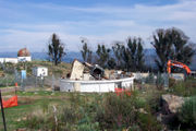
The drought conditions continued during the following years, and in 2003 the ACT burned again. The 2003 bushfires
damaged around 70% of the ACT's area, including 99% of the Tidbinbilla Nature Reserve and significant areas of government-owned pine plantation. Four people were killed and 67 rural houses were destroyed, including 16 houses at Uriarra, 12 at Pierces Creek; 414 houses in the outer suburbs of Canberra were razed.
More than 200 other houses were damaged, and numerous buildings of historical significance were lost, including the Mount Franklin Chalet, which was built in 1937–38 for the Canberra Alpine Club and was the first club-built ski lodge in mainland Australia, and many others in the Namadgi National Park. Nil Desperandum and Rock Valley Homestead, the two historic houses at Tidbinbilla, were destroyed. Most buildings of the Mount Stromlo Observatory
, operated by the Australian National University
, were destroyed, including the observatory's Oddie telescope and its dome, which had been built in 1911 and was the first federal building in the ACT.
Australian Capital Territory
The Australian Capital Territory, often abbreviated ACT, is the capital territory of the Commonwealth of Australia and is the smallest self-governing internal territory...
(ACT) as an administrative division of Australia
States and territories of Australia
The Commonwealth of Australia is a union of six states and various territories. The Australian mainland is made up of five states and three territories, with the sixth state of Tasmania being made up of islands. In addition there are six island territories, known as external territories, and a...
began after the Federation of Australia
Federation of Australia
The Federation of Australia was the process by which the six separate British self-governing colonies of New South Wales, Queensland, South Australia, Tasmania, Victoria and Western Australia formed one nation...
in 1901, when it was created in law as the site for Canberra
Canberra
Canberra is the capital city of Australia. With a population of over 345,000, it is Australia's largest inland city and the eighth-largest city overall. The city is located at the northern end of the Australian Capital Territory , south-west of Sydney, and north-east of Melbourne...
, Australia's capital city. The region has a long prior history of human habitation before the Territory's creation, with evidence of Indigenous Australian
Indigenous Australians
Indigenous Australians are the original inhabitants of the Australian continent and nearby islands. The Aboriginal Indigenous Australians migrated from the Indian continent around 75,000 to 100,000 years ago....
settlement dating back at least 21,000 years. The area formed the traditional lands associated with the Ngambri People and several other linguistic groups
Australian Aboriginal languages
The Australian Aboriginal languages comprise several language families and isolates native to the Australian Aborigines of Australia and a few nearby islands, but by convention excluding the languages of Tasmania and the Torres Strait Islanders...
, an association known through both early European settler accounts and the oral histories
Oral history
Oral history is the collection and study of historical information about individuals, families, important events, or everyday life using audiotapes, videotapes, or transcriptions of planned interviews...
of the peoples themselves.
Following the colonisation of Australia by the British, the 19th century saw the initial European exploration and settlement of the area and their encounters with the local indigenous peoples, beginning with the first explorations in 1820 and shortly followed by the first European settlements in 1824. At the outset the region was dominated by large properties used for sheep and cattle grazing, which had been granted to free settlers that had arrived in Australia from the United Kingdom and other European countries. These large properties were later broken up and subdivided in accordance with changes to land tenure
Land tenure
Land tenure is the name given, particularly in common law systems, to the legal regime in which land is owned by an individual, who is said to "hold" the land . The sovereign monarch, known as The Crown, held land in its own right. All private owners are either its tenants or sub-tenants...
arrangements, smaller farms and urban developments becoming more common.
In 1908, the region was selected as the site of the nation's future capital city. In 1909, New South Wales
New South Wales
New South Wales is a state of :Australia, located in the east of the country. It is bordered by Queensland, Victoria and South Australia to the north, south and west respectively. To the east, the state is bordered by the Tasman Sea, which forms part of the Pacific Ocean. New South Wales...
formally ceded to the federal government
Government of Australia
The Commonwealth of Australia is a federal constitutional monarchy under a parliamentary democracy. The Commonwealth of Australia was formed in 1901 as a result of an agreement among six self-governing British colonies, which became the six states...
the territory and additional land at Jervis Bay
Jervis Bay Territory
The Jervis Bay Territory is a territory of the Commonwealth of Australia. It was surrendered by the state of New South Wales to the Commonwealth Government in 1915 so that the Federal capital at Canberra would have "access to the sea"....
for the establishment of a sea port for the capital. The territory officially came under government control as the Federal Capital Territory on 1911. The planning and construction of Canberra followed, with the Parliament of Australia
Parliament of Australia
The Parliament of Australia, also known as the Commonwealth Parliament or Federal Parliament, is the legislative branch of the government of Australia. It is bicameral, largely modelled in the Westminster tradition, but with some influences from the United States Congress...
moving there in 1927.
The Territory officially became the Australian Capital Territory in 1938. Canberra was built to accommodate the government, while the surrounding area was developed to support the city, including the construction of dams, the establishment of plantation forests and the creation of protected areas
Protected areas of the Australian Capital Territory
The Australian Capital Territory contains 8 separate protected areas with a total land area of 1,230 km² . They are managed on territory level by Environment ACT.-Nature Reserves:*Bullen Range Nature Reserve*Canberra Nature Park...
. An advisory council was established in 1930, with some elected representation.
Initially, the growth of Canberra and the ACT was slow. The American architect Walter Burley Griffin
Walter Burley Griffin
Walter Burley Griffin was an American architect and landscape architect, who is best known for his role in designing Canberra, Australia's capital city...
won the competition to design Australia's new capital and was appointed to oversee its construction. He was frequently dogged by disputes with Australian authorities and the onset of World War I
World War I
World War I , which was predominantly called the World War or the Great War from its occurrence until 1939, and the First World War or World War I thereafter, was a major war centred in Europe that began on 28 July 1914 and lasted until 11 November 1918...
, which hindered progress. In 1921, Burley Griffin was fired, and multiple planning bodies were established, but achieved little, in part due to the Great Depression
Great Depression
The Great Depression was a severe worldwide economic depression in the decade preceding World War II. The timing of the Great Depression varied across nations, but in most countries it started in about 1929 and lasted until the late 1930s or early 1940s...
.
In the period after World War II
World War II
World War II, or the Second World War , was a global conflict lasting from 1939 to 1945, involving most of the world's nations—including all of the great powers—eventually forming two opposing military alliances: the Allies and the Axis...
, Prime Minister
Prime Minister of Australia
The Prime Minister of the Commonwealth of Australia is the highest minister of the Crown, leader of the Cabinet and Head of Her Majesty's Australian Government, holding office on commission from the Governor-General of Australia. The office of Prime Minister is, in practice, the most powerful...
Robert Menzies
Robert Menzies
Sir Robert Gordon Menzies, , Australian politician, was the 12th and longest-serving Prime Minister of Australia....
regarded the state of Canberra as an embarrassment, and took it upon himself to champion its development. Under his leadership —which lasted more than a decade— the development of the capital was rapid. The National Capital Development Commission
National Capital Development Commission
The National Capital Development Commission was an Australian Commonwealth Government body created to complete the establishment of Canberra as the seat of government. It was created in 1957 through the National Capital Development Commission Act 1957.Under the control of the NCDC Canberra grew...
was created in 1957 with more power than its predecessors, and ended four decades of disputes over the shape and design of Lake Burley Griffin
Lake Burley Griffin
Lake Burley Griffin is an artificial lake in the centre of Canberra, the capital of Australia. It was completed in 1963 after the Molonglo River—which ran between the city centre and Parliamentary Triangle—was dammed...
, the centrepiece of Canberra, and construction was completed in 1964 after four years of work.
This prompted the development of the Parliamentary Triangle
Parliamentary Triangle, Canberra
The Parliamentary Triangle is the ceremonial precinct of Canberra, containing some of Australia's most significant buildings. The triangle is formed by Commonwealth, Kings and Constitution avenues...
, a core part of Griffin's design, and since then various buildings of national importance were constructed on the lakefront. The Australian National University
Australian National University
The Australian National University is a teaching and research university located in the Australian capital, Canberra.As of 2009, the ANU employs 3,945 administrative staff who teach approximately 10,000 undergraduates, and 7,500 postgraduate students...
was built, and sculptures and monuments were built. On average, the population of Canberra increased by more than 50% every five years between 1955 and 1975 as the development of the capital became more concerted, and new residential land was released through the creation of new town centres in the 1960s and 1970s.
In 1949, the territory gained its first representative in the Parliament, although at first with limited speaking and voting rights. In 1974 it gained a fully elected, but still advisory House of Assembly
Australian Capital Territory House of Assembly
The Australian Capital Territory House of Assembly was the main elected representative body of the Australian Capital Territory between 1975 and 1986, when preparations began to be made for the granting of self-government to the Territory...
. In 1988 it gained the trappings of self-government with a Legislative Assembly
Australian Capital Territory Legislative Assembly
The Australian Capital Territory Legislative Assembly is the unicameral legislature of the Australian Capital Territory...
with most of the powers and responsibilities of an Australian state, although subject to a federal right of veto, similar to the arrangements adopted for the Northern Territory
Northern Territory
The Northern Territory is a federal territory of Australia, occupying much of the centre of the mainland continent, as well as the central northern regions...
in 1978. The Legislative Assembly legalised some things that were prohibited in other parts of Australia, such as prostitution and X-rated pornography; in 2006, an attempt to allow civil unions for same-sex couples was overruled by the federal government.
Pre-European history
Norman Tindale
Norman Barnett Tindale was an Australian anthropologist, archaeologist and entomologist. Born in Perth, his family moved to Tokyo from 1907 to 1915, where his father worked as an accountant at the Salvation Army mission in Japan. Soon after returning to Australia, Tindale got a job at the South...
has suggested the principal group occupying the region were the Ngunnawal people
Ngunnawal people
The Ngunnawal people are the Indigenous Australian inhabitants whose traditional lands encompass much of the area now occupied by the city of Canberra, Australia and the surrounding Australian Capital Territory...
, while the Ngarigo
Ngarigo
The Ngarigo is the Aboriginal people group whose traditional lands lie south-east of the Canberra area.According to Norman Tindale in his 1974 catalogue of Australian Aboriginal people groups, the specific areas lands of the Ngarigo are:...
and Walgalu
Walgalu
The Walgalu one of the two Aboriginal peoples who originally lived in the region now occupied by Canberra, the capital of Australia, and is officially recognised as the original indigenous australian custodian of country...
lived immediately to the south, the Wandandian to the east, the Gandangara to the north, and the Wiradjuri
Wiradjuri
The Wiradjuri are an Indigenous Australian group of central New South Wales.In the 21st century, major Wiradjuri groups live in Condobolin, Peak Hill, Narrandera and Griffith...
to the north-west.
Archæological evidence from the Birrigai rock shelter in Tidbinbilla Nature Reserve
Tidbinbilla Nature Reserve
Tidbinbilla Nature Reserve, on the fringe of Namadgi National Park, is a short drive from the city of Canberra, Australia. The reserve covers an area of approximately 54.50 km² and consists of a large valley floor, the Tidbinbilla Mountain and the Gibraltar range...
indicates habitation dating back at least 21,000 years. It is possible that the area was inhabited for considerably longer, with evidence of an Aboriginal presence in south-western New South Wales dating back around 40,000–62,000 years. Another site of significance in the reserve is the Bogong Rocks shelter, which contains the oldest evidence of Aboriginal occupation at a bogong moth
Bogong moth
The Bogong moth is a temperate species of night-flying moth notable for appearing in large numbers around major public buildings in Canberra, the capital city of Australia, during spring as it migrates to the High Plains. The moth's name 'Bogong' is the same as the mountain ranges on the High...
resting site. These insects were an important source of food for the Aboriginal peoples of the Southern Alps
Australian Alps
The Australian Alps are the highest mountain ranges of mainland Australia. They are located in southeastern Australia and straddle the Australian Capital Territory, south-eastern New South Wales and eastern Victoria...
and would accumulate by the thousands in caves and rock crevices, where they were collected and later roasted in sand or ashes, and then eaten whole.
Numerous other culturally significant and archæologically notable sites are known across the territory, including shelters, rock art sites, stone artefact scatters, scarred trees
Scarred trees
Scarred trees are trees which have had bark removed by indigenous Australians for the creation of canoes, shelters, shields and containers, such as coolamons. They are among the easiest to find archaeological sites in Australia....
and chert
Chert
Chert is a fine-grained silica-rich microcrystalline, cryptocrystalline or microfibrous sedimentary rock that may contain small fossils. It varies greatly in color , but most often manifests as gray, brown, grayish brown and light green to rusty red; its color is an expression of trace elements...
quarries. Tidbinbilla Mountain is believed to have long been used for Aboriginal initiation ceremonies.
19th century exploration
Following European settlement, the growth of the new colony of New South Wales led to an increasing demand for arable landArable land
In geography and agriculture, arable land is land that can be used for growing crops. It includes all land under temporary crops , temporary meadows for mowing or pasture, land under market and kitchen gardens and land temporarily fallow...
. Governor Lachlan Macquarie
Lachlan Macquarie
Major-General Lachlan Macquarie CB , was a British military officer and colonial administrator. He served as the last autocratic Governor of New South Wales, Australia from 1810 to 1821 and had a leading role in the social, economic and architectural development of the colony...
supported expeditions to open up new lands to the south of the capital Sydney
Sydney
Sydney is the most populous city in Australia and the state capital of New South Wales. Sydney is located on Australia's south-east coast of the Tasman Sea. As of June 2010, the greater metropolitan area had an approximate population of 4.6 million people...
, including one to find an overland route to Jervis Bay
Jervis Bay Territory
The Jervis Bay Territory is a territory of the Commonwealth of Australia. It was surrendered by the state of New South Wales to the Commonwealth Government in 1915 so that the Federal capital at Canberra would have "access to the sea"....
, an area which would later be incorporated into the ACT as its only coastal possession. In 1818 Charles Throsby
Charles Throsby
Charles Throsby was an Australian explorer, pioneer and parliamentarian. He opened up much new land beyond the Blue Mountains for colonial settlement. He was a grazier, and became a prominent member of New South Wales society.- Early life :...
, Hamilton Hume
Hamilton Hume
Hamilton Hume was the first Australian born explorer. Along with Hovell in 1824, Hume was part of an expedition that first took an overland route from Sydney to Port Phillip near the site of present day Melbourne...
, James Meehan
James Meehan
James Meehan was an Irish-Australian explorer and surveyor.Meehan was born in Ireland in 1774, and was one of a number of political prisoners who arrived in Australia in February 1800. Two months later he became an assistant to Charles Grimes, the surveyor-general, and went with him to explore the...
and William Kearns set out to find the route, a task accomplished that same year by Throsby and Kearns.
The 1820s saw further exploration in the Canberra area associated with the construction of a road from Sydney to the Goulburn
Goulburn, New South Wales
Goulburn is a provincial city in the Southern Tablelands of New South Wales, Australia in Goulburn Mulwaree Council Local Government Area. It is located south-west of Sydney on the Hume Highway and above sea-level. On Census night 2006, Goulburn had a population of 20,127 people...
plains, supervised by Throsby and his overseer, Joseph Wild
Joseph Wild
Joseph Wild was an early explorer of Australia. He was sentenced on 21 August 1793 in Chester for burglary, together with his brother, George. Both were transported to Australia as convicts in 1797, arriving in Port Jackson on the ship the Ganges on 2 June...
. While working on the project, Throsby learned of a nearby lake and river from the local Aborigines, and he accordingly sent Wild to lead a small party to investigate the site. On 1820, Wild ventured off from his two companions, and later that day arrived at the north shore of what is now known as Lake George
Lake George (New South Wales)
Lake George is a lake in south-eastern New South Wales, Australia about 30 minutes drive north-east of Canberra along the Federal Highway en route to Sydney.-Geography / Geology:...
. In Governor Macquarie visited the site, and while he was in attendance Throsby decided to push on to reach the river that he had been informed of. Accompanied by Wild and James Vaughan, he journeyed south in search of the Murrumbidgee
Murrumbidgee River
The Murrumbidgee River is a major river in the state of New South Wales, Australia, and the Australian Capital Territory . A major tributary of the Murray River, the Murrumbidgee flows in a west-northwesterly direction from the foot of Peppercorn Hill in the Fiery Range of the Snowy Mountains,...
. The search was unsuccessful, but they did discover the Yass River
Yass River
The Yass River is a river in the state of New South Wales, Australia. The town of Yass is located on the Yass River a short distance from its confluence with the Murrumbidgee River.There are two competing theories as to the origin of the name Yass...
, and it is surmised that they would have set foot on part of the future ACT.
A second expedition was mounted shortly thereafter, and Throsby's nephew Charles Throsby Smith, Wild and Vaughan further explored the Molonglo
Molonglo River
The Molonglo River rises on the western side of the Great Dividing Range of eastern Australia in the state of New South Wales. Its source is on the other side of the mountain range from where the Shoalhaven River rises, in Tallaganda state forest at ~1200 metres altitude...
(Ngambri) and Queanbeyan
Queanbeyan River
The Queanbeyan River is a tributary of the Molonglo River and part of Murray-Darling Basin. The river is 70 kilometres in length and the river catchment is 96,000 hectares in size...
(Jullergung) Rivers, becoming the first Europeans to camp at the site. However, they failed to find the Murrumbidgee, and Smith declared that the river did not exist. The issue of the Murrumbidgee was solved in 1821, when Charles Throsby mounted a third expedition and successfully reached the watercourse, on the way providing the first detailed account of the land where Canberra now resides.
The next significant expedition to the region came in 1823, when Wild was employed by Brigade Major John Ovens and Captain Mark Currie to guide them to the Murrumbidgee. They travelled south along the river and named the area now known as Tuggeranong Isabella's Plain, after Isabella Maria Brisbane (1821–1849), the two-year-old daughter of Thomas Brisbane
Thomas Brisbane
Major-General Sir Thomas Makdougall Brisbane, 1st Baronet GCH, GCB, FRS, FRSE was a British soldier, colonial Governor and astronomer.-Early life:...
, the then Governor of New South Wales. Unable to cross the river near the current site of Tharwa
Tharwa, Australian Capital Territory
Tharwa is a small village within the Australian Capital Territory, south of Canberra, the capital city of Australia. At the 2006 census, Tharwa had a population of 109....
, they continued on to the Monaro Plains. The last expedition in the region prior to settlement was undertaken by Allan Cunningham
Allan Cunningham (botanist)
Allan Cunningham was an English botanist and explorer, primarily known for his travels in New South Wales to collect plants.- Early life :...
in 1824. He reported that the region was suitable for grazing, and the settlement of the Limestone Plains followed immediately thereafter.
Early Settlement
Nineteen Counties
The Nineteen Counties were the limits of location in the colony of New South Wales defined by the Governor of New South Wales Sir Ralph Darling in 1826 in accordance with a government order from Lord Bathurst, the secretary of State. Counties had been used since the first year of settlement, with...
of New South Wales
New South Wales
New South Wales is a state of :Australia, located in the east of the country. It is bordered by Queensland, Victoria and South Australia to the north, south and west respectively. To the east, the state is bordered by the Tasman Sea, which forms part of the Pacific Ocean. New South Wales...
were determined, the Limestone Plains were opened up to settlers. The first land grant in the region was made to Joshua John Moore in 1823, and settlement in the area began in 1824 with the construction of a homestead by his stockmen on what is now the Acton Peninsula
Acton Peninsula
The Acton Peninsula is located on the northern shore of Lake Burley Griffin, in the centre of Canberra, the capital of Australia.It was created when the lake was artificially built by damming the Molonglo River and excavating around it to create the desired shape.The Royal Canberra Hospital used to...
. Moore formally purchased the site in 1826 and named the property Canberry, or Canberra, although he never visited it. His 4 km² (1.5 sq mi) claim covered much of the future North Canberra
North Canberra
North Canberra, also known as the Inner North, is a district of Canberra, the capital city of Australia, comprising 14 suburbs with 19,115 dwellings housing 42,113 people of the 324,034 people in the Australian Capital Territory...
.
Adjacent to the eastern boundary on Moore's claim was the settlement of Duntroon
Duntroon, Australian Capital Territory
Duntroon is a suburb of the city of Canberra in the Australian Capital Territory.-History:Robert Campbell's property Duntroon was situated on the limestone plains of New South Wales in the area that is now covered by the ACT....
, occupied by James Ainslie
James Ainslie (pastoralist)
James Ainslie was a Scottish pastoralist, best known as the first overseer of the property known as Duntroon in the Australian Capital Territory, he increased the size of the property's sheep flock from 700 to 20,000 in 12 years. He lived in a relationship with an Aboriginal woman and she bore him...
on behalf of Robert Campbell. John Palmer was granted land in the region, which was taken up by his son George in 1826. He established Palmerville near Ginninderra Creek
Ginninderra Creek
Ginninderra Creek is a water course that flows across the Ginninderra Plain through the Gungahlin and Belconnen regions in Canberra, Australia....
in 1829, and the "Squire" at Gungahlin
Gungahlin
Gungahlin is a name of a district and the northernmost town centre of Canberra, Australia. Gungahlin is situated 10 km north of Canberra's city centre and is one of five satellites of Canberra including Woden, Tuggeranong, Weston Creek and Belconnen. Currently Gungahlin comprises 11 suburbs,...
was completed in 1861. Palmerville in the Ginninderra
Ginninderra
Ginninderra is the name of the former agricultural lands surrendered to urban development on the western and north-western fringes of Canberra, Australia's National Capital...
district was the site of first school in the region, and operated from 1844 to 1848. The first school in the future Canberra opened on the Duntroon Estate, next door to St John's Church
St John the Baptist Church, Reid
St John the Baptist Church is the oldest church in Canberra, Australia, and also the oldest building within Canberra's city precinct. It is sited at the corner of ANZAC Parade and Constitution Avenue in the suburb of Reid.-Construction:...
in what would become the suburb of Reid in the 20th century. Canberra's first church, St John's, was consecrated and opened for use in 1845.
The Tuggeranong
Tuggeranong
Tuggeranong is the southernmost town centre of Canberra, the capital city of Australia. It comprises 19 suburbs with a total of 31,819 dwellings, housing 87,119 people of the 324,034 people in the Australian Capital Territory . The district occupies 117 square kilometres to the east of the...
Plains, situated 10 km (6.2 mi) south of the Molonglo River, were first settled in 1827 by Peter Murdoch. The Waniassa Homestead (also known as Tuggeranong Homestead) was established in 1836 by John McQuoid, and the first buildings of the Lanyon estate, owned by John Lanyon and James Wright, were built in 1838. Tharwa
Tharwa, Australian Capital Territory
Tharwa is a small village within the Australian Capital Territory, south of Canberra, the capital city of Australia. At the 2006 census, Tharwa had a population of 109....
was settled in 1834; the homestead in this area was Cuppacumbalong
Cuppacumbalong Homestead
Cuppacumbalong is an historic homestead located near the southern outskirts of Canberra in the Australian Capital Territory. It is also the name of a former sheep and cattle grazing property that surrounded the homestead near the junction of the Murrumbidgee and Gudgenby Rivers. The word...
, established by James Wright in 1839. Tharwa is the oldest official settlement in the ACT, having being proclaimed in 1862.
Settlers moved further south into what is now the Namadgi National Park
Namadgi National Park
Namadgi National Park is located in the southwestern part of the Australian Capital Territory, bordering Kosciuszko National Park in New South Wales. It lies approximately 40 km southwest of Canberra, and makes up approximately 46% of the ACT's land area....
. William Herbert made a claim over part of the Orroral Valley at some point between 1826 and 1836, while during the 1830s Garrett Cotter
Garrett Cotter
Garrett Cotter was an Australian convict. The Cotter River in the Australian Capital Territory is named after him.From circa 1827, Garret Cotter inhabited the Cotter Valley and the Cotter River received its name by association. Cotter was born in 1802 in County Cork. He had been a ploughman and...
inhabited what would later be named the Cotter River
Cotter River
The Cotter River is a fresh water river in the Australian Capital Territory. It is a tributary of the Murrumbidgee River and part of Murray-Darling Basin. The Cotter River is one of two rivers—the Queanbeyan River is the other—that meet the water supply needs of the Canberra and...
Valley, in his honour. From the late 1830s, the Boboyan Homestead and station were established. Gudgenby was settled in the early 1840s and the Gudgenby Homestead was erected around this time. By 1848 most of the major valleys of the Namadgi area had been settled.
Convict labour was widely used in the region, and the first bushranger
Bushranger
Bushrangers, or bush rangers, originally referred to runaway convicts in the early years of the British settlement of Australia who had the survival skills necessary to use the Australian bush as a refuge to hide from the authorities...
s in the area were runaway convicts. John Tennant, the earliest and best-known bushranger of the region, lived in a hideout on what is now known as Mount Tennant, behind Tharwa. From 1827 he raided the local homesteads, stealing stock, food and possessions until his arrest in 1828; He was later hung in Sydney for his crimes. The lawlessness of the region led to the appointment of the first resident magistrate on 1837 – Allured Tasker Faunce, who was also known as "Ironman Faunce" since his time as a magistrate at Brisbane Water
Brisbane Water
Brisbane Water is the northern arm of Broken Bay on the east coast of New South Wales Australia. Brisbane Water is named after Sir Thomas Brisbane, Governor of New South Wales between 1820 and 1825...
. The magistrate oversaw legal matters and issued liquor licenses to several establishments, the first being the Elmsall Inn on the Duntroon estate in 1841.
A significant influx of population and economic activity occurred around the 1850s goldrushes
Australian gold rushes
The Australian gold rush started in 1851 when prospector Edward Hammond Hargraves claimed the discovery of payable gold near Bathurst, New South Wales, at a site Edward Hargraves called Ophir.Eight months later, gold was found in Victoria...
, particularly the Kiandra rush of 1859–60. The goldrushes prompted the establishment of communication between Sydney and the region by way of the Cobb & Co
Cobb and Co
Cobb and Co is the name of a transportation company in Australia. It was prominent in the late 19th century when it operated stagecoaches to many areas in the outback and at one point in several other countries, as well....
coaches, which transported mail and passengers. The first post offices opened in Ginninderra in 1859 and at Lanyon the following year. Bushranger activity continued with the goldrushes: Australian-born bandits Ben Hall and the Clarke brothers
Clarke brothers
The Clarke brothers were Australian bushrangers active in New South Wales the late 19th century.The Clarke brothers, Thomas and John and James, were from Braidwood, New South Wales. From 1865 they were active around the area that became the Australian Capital Territory, where they held up stations,...
were active in the area, targeting mail coach
Mail coach
In Great Britain, the mail coach or post coach was a horse-drawn carriage that carried mail deliveries, from 1784. In Ireland, the first mail coach began service from Dublin in 1789. The coach was drawn by four horses and had seating for four passengers inside. Further passengers were later allowed...
es and gold transportation.
Terence Aubrey Murray was born in Ireland in 1810 and came to Sydney with his father, a retired redcoat army officer, and siblings in 1827. In 1837, he acquired the Yarralumla
Government House, Canberra
Government House, Canberra, commonly known as Yarralumla, is the official residence of the Governor-General of Australia. It is located in the suburb of Yarralumla, in the City of Canberra, in the Australian Capital Territory....
sheep station, taking up residence in Yarralumla's Georgian-style homestead, which he extended. He was elected unopposed to represent the surrounding Counties of Murray
Murray County, New South Wales
Murray County was one of the original Nineteen Counties in New South Wales and is now one of the 141 Lands administrative divisions of New South Wales. It included the area which is now part of Canberra and as far north as Lake George and Yass. It was originally bounded on the west by the...
, King
King County, New South Wales
King County was one of the original Nineteen Counties in New South Wales and is now one of the 141 Cadastral divisions of New South Wales. It is in the area to the east of Yass. The northern part of it lies between the Lachlan River and the Boorowa River, including the locations of Frogmore,...
and Georgiana
Georgiana County, New South Wales
Georgiana County was one of the original Nineteen Counties in New South Wales and is now one of the 141 Cadastral divisions of New South Wales. It lies in the area about halfway between Bathurst and Goulburn. The Lachlan River is the western boundary, with the Crookwell River the southern boundary....
in the first partially elective Legislative Council
New South Wales Legislative Council
The New South Wales Legislative Council, or upper house, is one of the two chambers of the parliament of New South Wales in Australia. The other is the Legislative Assembly. Both sit at Parliament House in the state capital, Sydney. The Assembly is referred to as the lower house and the Council as...
in 1843. With the establishment of responsible government
Responsible government
Responsible government is a conception of a system of government that embodies the principle of parliamentary accountability which is the foundation of the Westminster system of parliamentary democracy...
in 1856, Murray became a member of the first Legislative Assembly
Members of the New South Wales Legislative Assembly, 1856–1858
This is a list of members of the New South Wales Legislative Assembly from 1856 to 1858:This is a list of members of the New South Wales Legislative Assembly from 1856 to 1858:...
, representing the electorate of Southern Boroughs
Electoral district of Southern Boroughs
Southern Boroughs was a former electoral district for the Legislative Assembly in the Australian state of New South Wales created in 1856. It included the towns of Goulburn, Braidwood, Yass and Queanbeyan, while the surrounding rural area were in the electoral districts of Argyle, United Counties...
– which included nearby Queanbeyan
Queanbeyan, New South Wales
Queanbeyan is a regional centre in the Southern Tablelands in south-eastern New South Wales adjacent to the Australian Capital Territory. The city's mixed economy is based on light construction, high technology, manufacturing, service, retail and agriculture. It is the council seat of the...
– and in 1859 he was elected to represent Argyle
Electoral district of Argyle
Argyle was an electoral district for the Legislative Assembly in the Australian State of New South Wales from 1856 to 1904, including Argyle County surrounding Goulburn...
– which included another of his pastoral properties, Winderradeen, in the Collector
Collector, New South Wales
Collector is a small village on the Federal Highway in New South Wales, Australia halfway between Goulburn and the Australian Capital Territory. It is seven kilometres north of Lake George...
area, north of Canberra.
The Robertson Land Acts
Robertson Land Acts
The Crown Lands Acts 1861 were introduced by the New South Wales Premier, John Robertson, in 1861 to reform land holdings and in particular to break the squatters' domination of land tenure...
and the Closer Settlement Acts
Closer Settlement Acts
The Closer Settlement Acts were introduced by the New South Wales parliament between 1901 and 1909 to reform land holdings and in particular to break the squatters' domination of land tenure....
altered the mechanism for granting land tenure
Land tenure
Land tenure is the name given, particularly in common law systems, to the legal regime in which land is owned by an individual, who is said to "hold" the land . The sovereign monarch, known as The Crown, held land in its own right. All private owners are either its tenants or sub-tenants...
and precipitated the break-up of large properties in New South Wales. During the 1860s, in the wake of the new government legislation, small farmers nicknamed "selectors" moved into what would become the ACT, taking up parcels of (usually inferior) land which existed between the estates of the wealthy, established landholders.
During colonial times, prior to the establishment of the ACT, the European communities of Ginninderra, Molonglo
Molonglo Plains
The Molonglo Plain generally refers to the flood plain of the Molonglo River and specifically the one located in the Australian Capital Territory that was inundated during the mid 1960s in order to create Lake Burley Griffin...
and Tuggeranong settled in and farmed the surrounding land, raising sheep in the main but also breeding horses and growing grain. The region was also called the Queanbeyan/Yass
Yass, New South Wales
Yass is a town in the Southern Tablelands of New South Wales, Australia in Yass Valley Shire. The name appears to have been derived from an Aboriginal word, "Yarrh" , said to mean 'running water'....
district, after the two largest towns in the area. The villages of Ginninderra and Tharwa developed to service the local agrarian communities. In 1882, the first allotments in the village of Hall – named after early pastoralist Henry Hall – were sold. By 1901, it was an established town with a hotel, coachbuilder, blacksmith, butcher, shoemaker, saddler, dairy and two stores.
In 1886, the agronomist William Farrer
William Farrer
William James Farrer was a leading Australian agronomist and plant breeder. Farrer is best remembered as the originator of the "Federation" strain of wheat, distributed in 1903...
, established the research farm 'Lambrigg' on the banks of the Murrumbidgee south of present-day Tuggeranong. Farrer experimented with rust and drought-resistant wheat; the varieties he bred were widely used by Australian growers, and he was later credited with establishing Australia as a major producer. Tharwa Bridge, the oldest surviving bridge in the region, was opened in 1895 and was the first crossing over the Murrumbidgee River. By 1911, when the region came under federal control, the population had grown to 1,714 settlers.
Relations with indigenous people
During the first 20 years of settlement, there was only limited contact between the settlers and Aborigines. Joseph Franklin purchased land in the BrindabellasBrindabella Ranges
The Brindabella Range is a mountain range located on the border between New South Wales and the Australian Capital Territory, Australia. The ranges rise to the west of Canberra, the capital city of Australia, and include the Namadgi National Park in the A.C.T. and Bimberi Nature Reserve and...
in 1849 and attempted to set up a cattle farm. His livestock was slaughtered by the local Aborigines and he was driven back out of the mountains. The rush of prospectors into the Kiandra area through the Brindabellas and the mountains to the west of the ACT as a result of the Kiandra goldrush led to conflict with the Aboriginal people. By the time Franklin returned to the Brindabellas in 1863, the indigenous population had been significantly reduced.
Over the succeeding years, the Ngunnawal and other local Indigenous people effectively ceased to exist as cohesive and independent communities adhering to their traditional ways of life. Those who had not succumbed to disease and other predations either dispersed to the local settlements or were relocated to more distant Aboriginal reserves set up by the NSW government in the latter part of the 19th century. The children of mixed European-Aboriginal families were generally expected to assimilate into the settlement communities. The Ngunnawal people were subsequently often considered to be "extinct"; however, in a situation parallel to that of the Tasmanian Aborigines
Tasmanian Aborigines
The Tasmanian Aborigines were the indigenous people of the island state of Tasmania, Australia. Before British colonisation in 1803, there were an estimated 3,000–15,000 Parlevar. A number of historians point to introduced disease as the major cause of the destruction of the full-blooded...
, people with claims to Ngunnawal ancestry continue to identify themselves as such. However, there have been contemporary instances of dispute within the community itself over who is properly considered to be a member of the Ngunnawal people.
Search for a capital city location
The district's change from a New South Wales rural area to the national capital began with the debates over FederationFederation of Australia
The Federation of Australia was the process by which the six separate British self-governing colonies of New South Wales, Queensland, South Australia, Tasmania, Victoria and Western Australia formed one nation...
during the 19th century. Prior to 1840 Sydney
Sydney
Sydney is the most populous city in Australia and the state capital of New South Wales. Sydney is located on Australia's south-east coast of the Tasman Sea. As of June 2010, the greater metropolitan area had an approximate population of 4.6 million people...
was the administrative centre for the colony, and thus it could be presupposed that any potential federal government would be seated there. However, this started to change when, buoyed by the Victorian Gold Rush
Victorian gold rush
The Victorian gold rush was a period in the history of Victoria, Australia approximately between 1851 and the late 1860s. In 10 years the Australian population nearly tripled.- Overview :During this era Victoria dominated the world's gold output...
, Melbourne
Melbourne
Melbourne is the capital and most populous city in the state of Victoria, and the second most populous city in Australia. The Melbourne City Centre is the hub of the greater metropolitan area and the Census statistical division—of which "Melbourne" is the common name. As of June 2009, the greater...
grew rapidly, and by 1860 its population had overtaken that of Sydney. The discovery of gold also helped to increase Melbourne's financial base, to the point where at one stage "nearly 5% of all British imperial government revenue ... passed through [Melbourne's] port". Thus Melbourne soon possessed both the size and the economic clout to rival Sydney and to command additional administrative powers.
John Dunmore Lang
John Dunmore Lang , Australian Presbyterian clergyman, writer, politician and activist, was the first prominent advocate of an independent Australian nation and of Australian republicanism.-Background and Family:...
, backed Sydney, but Henry Parkes
Henry Parkes
Sir Henry Parkes, GCMG was an Australian statesman, the "Father of Federation." As the earliest advocate of a Federal Council of the colonies of Australia, a precursor to the Federation of Australia, he was the most prominent of the Australian Founding Fathers.Parkes was described during his...
, a prominent New South Wales politician and Premier, proposed the capital be founded on "neutral ground", nominating the town of Albury
Albury, New South Wales
Albury is a major regional city in New South Wales, Australia, located on the Hume Highway on the northern side of the Murray River. It is located wholly within the boundaries of the City of Albury Local Government Area...
as a location. (Albury was located in New South Wales, yet its position on the Murray River
Murray River
The Murray River is Australia's longest river. At in length, the Murray rises in the Australian Alps, draining the western side of Australia's highest mountains and, for most of its length, meanders across Australia's inland plains, forming the border between New South Wales and Victoria as it...
placed it on the border between New South Wales and Victoria).
In 1898, a referendum on a proposed Constitution was held in four of the colonies – New South Wales, Victoria, South Australia
South Australia
South Australia is a state of Australia in the southern central part of the country. It covers some of the most arid parts of the continent; with a total land area of , it is the fourth largest of Australia's six states and two territories.South Australia shares borders with all of the mainland...
and Tasmania
Tasmania
Tasmania is an Australian island and state. It is south of the continent, separated by Bass Strait. The state includes the island of Tasmania—the 26th largest island in the world—and the surrounding islands. The state has a population of 507,626 , of whom almost half reside in the greater Hobart...
. Although the referendum achieved a majority in all four colonies, the New South Wales referendum failed to gain the minimum number of votes needed for the bill to pass. Following this result, a meeting of the four Premiers in 1898 heard from George Reid
George Reid (Australian politician)
Sir George Houstoun Reid, GCB, GCMG, KC was an Australian politician, Premier of New South Wales and the fourth Prime Minister of Australia....
, the Premier of New South Wales, who argued that locating the future capital in New South Wales would be sufficient to ensure the passage of the Bill. This was accepted by the other three Premiers, and the proposed Australian Constitution
Constitution of Australia
The Constitution of Australia is the supreme law under which the Australian Commonwealth Government operates. It consists of several documents. The most important is the Constitution of the Commonwealth of Australia...
was modified so that Section 125 specified that the national capital must be "within the state of New South Wales". However, they also added the condition that it must be situated no less than 100 mi (160.9 km) from Sydney. In addition, if the bill passed, Melbourne would be the interim seat of government (but not referred to as the "capital") until a location for the new capital had been determined. The 1899 referendum on this revised bill was successful, passing with sufficient numbers.
Bombala, New South Wales
Bombala is a town in the Monaro region of south-eastern New South Wales, Australia, in Bombala Council. It is located approximately south of the state capital, Sydney, and south of the town of Cooma. The name derives from an Aboriginal word meaning "Meeting of the waters". The town lies on the...
district in the far south of NSW was proposed, to which southern Monaro, (which incorporated Bombala), Orange
Orange, New South Wales
Orange is a city in the Central West region of New South Wales, Australia. It is west of the state capital, Sydney, at an altitude of . Orange has an estimated population of 39,329 and the city is a major provincial centre....
and Yass
Yass, New South Wales
Yass is a town in the Southern Tablelands of New South Wales, Australia in Yass Valley Shire. The name appears to have been derived from an Aboriginal word, "Yarrh" , said to mean 'running water'....
were soon added. The NSW Premier, John See
John See
Sir John See, KCMG was a member of the New South Wales Legislature from 26 November 1880 to 15 June 1901, and was then Premier of New South Wales from 1901 to 1904....
, offered to provide any of the three recommended sites as a future capital territory. Edmund Barton
Edmund Barton
Sir Edmund Barton, GCMG, KC , Australian politician and judge, was the first Prime Minister of Australia and a founding justice of the High Court of Australia....
, the first Prime Minister
Prime Minister of Australia
The Prime Minister of the Commonwealth of Australia is the highest minister of the Crown, leader of the Cabinet and Head of Her Majesty's Australian Government, holding office on commission from the Governor-General of Australia. The office of Prime Minister is, in practice, the most powerful...
of the new Federal government, added another four sites to this list: Albury, Tamworth
Tamworth, New South Wales
Tamworth is a city in the New England region of New South Wales, Australia. Straddling the Peel River, Tamworth, which contains an estimated population of 47,595 people, is the major regional centre for southern New England and in the local government area of Tamworth Regional Council. The city...
, Armidale
Armidale, New South Wales
Armidale is a city in the Northern Tablelands, New South Wales, Australia. Armidale Dumaresq Shire had a population of 19,485 people according to the 2006 census. It is the administrative centre for the Northern Tablelands region...
and Tumut
Tumut, New South Wales
Tumut is a town in the Riverina region of New South Wales, Australia, situated on the banks of the Tumut River. Tumut is at the foothills of the Snowy Mountains and is referred to as the gateway to the Snowy Mountains Scheme...
, and members of the new government toured the various sites in 1902. The tour proved inconclusive, and upon their return the members decided to refer the problem to a Royal Commission
Royal Commission
In Commonwealth realms and other monarchies a Royal Commission is a major ad-hoc formal public inquiry into a defined issue. They have been held in various countries such as the United Kingdom, Australia, Canada, New Zealand, and Saudi Arabia...
, with the Minister for Home Affairs, William Lyne
William Lyne
Sir William John Lyne KCMG , Australian politician, was Premier of New South Wales and a member of the first federal ministry.-Early life:...
, pushing for Tumut or Albury as he preferred a site in his electorate. Subsequently, the Commission presented its report to parliament in 1903, recommending the sites of Albury
Albury, New South Wales
Albury is a major regional city in New South Wales, Australia, located on the Hume Highway on the northern side of the Murray River. It is located wholly within the boundaries of the City of Albury Local Government Area...
, Tumut
Tumut, New South Wales
Tumut is a town in the Riverina region of New South Wales, Australia, situated on the banks of the Tumut River. Tumut is at the foothills of the Snowy Mountains and is referred to as the gateway to the Snowy Mountains Scheme...
and Orange
Orange, New South Wales
Orange is a city in the Central West region of New South Wales, Australia. It is west of the state capital, Sydney, at an altitude of . Orange has an estimated population of 39,329 and the city is a major provincial centre....
, in that order. However, there continued to be problems, as the House of Representatives backed the Tumut option, while the Senate preferred the town of Bombala. As a result of this disagreement the bill lapsed, and it was left to the second Parliament to choose a location for the capital.
The new Parliament met in 1904 and reached a compromise, choosing Dalgety
Dalgety, New South Wales
Dalgety is a small town in New South Wales Australia, on the banks of the Snowy River between Melbourne and Sydney.The town is located at what was once an important river crossing along the Travelling Stock route from Gippsland to the Snowy Mountains High Country dating from the 1840s.- History...
, which, like Bombala, was located in the Monaro region. Thus, with the passage of the Seat of Government Act 1904
Seat of Government Act 1904
The Seat of Government Act 1904 was an Australian Commonwealth Government Act selecting the Area around Dalgety, New South Wales as the site for the Federal Capital Territory ....
, it appeared that the matter had been settled. However, while the Federal Parliament supported Dalgety, the New South Wales government did not, and they proved unwilling to cede the amount of territory the federal government demanded.
Yass, New South Wales
Yass is a town in the Southern Tablelands of New South Wales, Australia in Yass Valley Shire. The name appears to have been derived from an Aboriginal word, "Yarrh" , said to mean 'running water'....
-Canberra
Canberra
Canberra is the capital city of Australia. With a population of over 345,000, it is Australia's largest inland city and the eighth-largest city overall. The city is located at the northern end of the Australian Capital Territory , south-west of Sydney, and north-east of Melbourne...
region, this site being closer to Sydney. Following a tour of the region by several Senators and Members of the Commonwealth Parliament, in 1908 a new ballot was called in the Federal Parliament with eleven sites nominated. Initially, Dalgety remained at the forefront, but by the eighth round Yass-Canberra had emerged as a new leader, and the site was confirmed in the ninth round of voting. Thus was passed the new Seat of Government Act 1908
Seat of Government Act 1908
The Seat of Government Act 1908 was enacted by the Australian Government on 14 December 1908. The act selected the Yass-Queanbeyan region as the site for Canberra, the new capital city of Australia....
, which repealed the 1904 Act and specified a capital in the Yass-Canberra region.
Government Surveyor Charles Scrivener
Charles Scrivener
Charles Robert Scrivener was an Australian surveyor, and the person who surveyed numerous sites in New South Wales for the selection of a site for the Australian Capital Territory and Australia's capital city, Canberra....
was deployed to the region in the same year in order to map out a specific site and, after an extensive search, settled upon the present location, about 300 km (186.4 mi) south-west of Sydney in the foothills of the Australian Alps.
Establishment of the Territory in law (1910)
Seat of Government Acceptance Act 1909
The Seat of Government Acceptance Act 1909 is an Australian Commonwealth Government act, that in conjunction with the Seat of Government Surrender Act 1909 transferred land from the state of New South Wales to the Commonwealth for the creation of the Federal Capital Territory .The act was signed on...
and the Seat of Government Surrender Act 1909
Seat of Government Surrender Act 1909
The Seat of Government Surrender Act 1909 was an Act of the New South Wales Parliament which completed the transfer of land from New South Wales to establish the Federal Capital Territory as the seat of Commonwealth government...
. The Act transferred Crown land
Crown land
In Commonwealth realms, Crown land is an area belonging to the monarch , the equivalent of an entailed estate that passed with the monarchy and could not be alienated from it....
in the counties of Murray
Murray County, New South Wales
Murray County was one of the original Nineteen Counties in New South Wales and is now one of the 141 Lands administrative divisions of New South Wales. It included the area which is now part of Canberra and as far north as Lake George and Yass. It was originally bounded on the west by the...
and Cowley
Cowley County, New South Wales
Cowley County is one of the 141 Cadastral divisions of New South Wales. It contains the locality of Cavan. It was originally bordered on the north, east and part of the south by the Murrumbidgee River, and on the west by the Goodradigbee River...
to the Commonwealth, which amounted to an area about 2330 square kilometres (899.6 sq mi) and eight parcels of land near Jervis Bay
Jervis Bay Territory
The Jervis Bay Territory is a territory of the Commonwealth of Australia. It was surrendered by the state of New South Wales to the Commonwealth Government in 1915 so that the Federal capital at Canberra would have "access to the sea"....
. All private land in the surrendered area had to be bought by the Commonwealth. The Seat of Government Acceptance Act also gave the Commonwealth rights to use and control the waters of the Queanbeyan and Molonglo River
Molonglo River
The Molonglo River rises on the western side of the Great Dividing Range of eastern Australia in the state of New South Wales. Its source is on the other side of the mountain range from where the Shoalhaven River rises, in Tallaganda state forest at ~1200 metres altitude...
s.
In 1910, the Seat of Government (Administration) Act 1910
Seat of Government (Administration) Act 1910
The Seat of Government Act 1910 is an Australian Commonwealth Government act. The act established the Federal Capital Territory's laws based on the laws of New South Wales up until 1911. From 1911 onwards the laws of the territory would be created by the Commonwealth and Governor-General...
created the legal framework for the Territory. The act specified that laws in the Territory could be made by the Commonwealth and that Ordinances could be made by the Governor-General, and placed the ACT under the jurisdiction of the New South Wales Supreme Court
Supreme Court of New South Wales
The Supreme Court of New South Wales is the highest state court of the Australian State of New South Wales...
. When the Act came into force on 1911, control of the Territory was officially assumed by the Commonwealth. This Act remained the constitutional basis for law-making in the ACT until the granting of self-government in 1989.
The Minister for Home Affairs
Minister for Home Affairs (Australia)
The Australian Minister for Home Affairs has been Brendan O'Connor since 6 June 2009. The Home Affairs portfolio brings together agencies such as the Australian Customs Service , the Australian Federal Police and the Australian Security Intelligence Organisation, which were previously the...
, King O'Malley
King O'Malley
King O'Malley was an Australian politician. He was a member in the South Australian House of Assembly from 1896 to 1899, and the Australian House of Representatives from 1901 to 1917. O'Malley was also Minister for Home Affairs in the second and third Fisher Labor ministry...
, who was responsible for the legislation creating the ACT, also introduced a bill in 1910 making the ACT an alcohol-free area; this bill was passed by the Federal parliament and the law was not repealed until 1928. Until that time local residents travelled to Queanbeyan
Queanbeyan, New South Wales
Queanbeyan is a regional centre in the Southern Tablelands in south-eastern New South Wales adjacent to the Australian Capital Territory. The city's mixed economy is based on light construction, high technology, manufacturing, service, retail and agriculture. It is the council seat of the...
, just across the New South Wales border, to drink on Saturday. In 1938 the Territory was formally renamed the Australian Capital Territory.
The Jervis Bay Territory Acceptance Act 1915
Jervis Bay Territory Acceptance Act 1915
The Jervis Bay Territory Acceptance Act 1915 was an Act of the Parliament of Australia which followed the New South Wales, Seat of Government Surrender Act 1915. The Act created the Territory of Jervis Bay, as a part of the Federal Capital Territory and with all laws of the FCT...
and the New South Wales Seat of Government Surrender Act 1915
Seat of Government Surrender Act 1915
The Seat of Government Surrender Act 1915 was an Act of the New South Wales Parliament transferring land from New South Wales to establish the Jervis Bay Territory as part of the Federal Capital Territory. The Jervis Bay Territory Acceptance Act 1915 was the corresponding Commonwealth Act accepting...
created a Territory of Jervis Bay
Jervis Bay Territory
The Jervis Bay Territory is a territory of the Commonwealth of Australia. It was surrendered by the state of New South Wales to the Commonwealth Government in 1915 so that the Federal capital at Canberra would have "access to the sea"....
, which was administered as part of the Federal Capital Territory and with all laws of the Territory applicable.
Resumption and disenfranchisement
Prior to the final decision on the location of the new capital territory, the local landowners and residents of Queanbeyan looked favourably on the possibility of having the territory located nearby. Such a result, it was hoped, would bring improvements to local infrastructure, increase the demand for local goods and services, and raise land values. It was assumed that the existing freehold arrangements would remain, and that those whose land was not required for the city itself would be in a position to capitalise on the new circumstances.Such was not the case. Legislation restricted land holdings in the new territory to leasehold, rather than freehold. This was intended to avoid land speculation and give the national government, as the lessor, greater control over development. Landowners were concerned that the legislation had a number of shortcomings: land valuations were fixed to the date when the Act passed ( 1908), there was no compensation for improvements made to the land, and owners were not given first right of refusal when their old land was offered for lease.
Along with the loss of their land, local residents discovered that they had been disenfranchised. Now a part of the ACT, they had lost their vote in the New South Wales government, and their numbers were too small to warrant a seat in the new federal parliament. As a result they had no representation in parliament through which to argue against the provisions of the legislation.
In response the residents formed the Vigilance Association with the intent of protecting their interests during the establishment of the new capital territory. Legal challenges to the resumption of the land were unsuccessful, but the Vigilance Association did win some concessions: the government agreed to pay for the improvements to the land, and did so at the value when the land was acquired; and the landowners gained the right of first refusal on their old properties when they were put up for lease. As of 2010 all residential land in the ACT is held on a 99-year crown lease.
20th century development of Canberra
One of the first federal facilities established in the Territory was the Royal Military College
Royal Military College, Duntroon
The Royal Military College, Duntroon is the Australian Army's officer training establishment. It was founded at Duntroon, in the Australian Capital Territory, in 1911 and is situated on picturesque grounds at the foot of Mount Pleasant near Lake Burley Griffin, close to the Department of Defence...
, established on the Campbells' property Duntroon
Duntroon, Australian Capital Territory
Duntroon is a suburb of the city of Canberra in the Australian Capital Territory.-History:Robert Campbell's property Duntroon was situated on the limestone plains of New South Wales in the area that is now covered by the ACT....
, which opened in 1911. Prior to this, Australia's military lacked formally trained officers, who were needed due to changes to the Australian military model that had emerged after Federation.
In the same year, an international competition to design the future capital was held, which was won by the Chicago architect Walter Burley Griffin
Walter Burley Griffin
Walter Burley Griffin was an American architect and landscape architect, who is best known for his role in designing Canberra, Australia's capital city...
in 1912. Griffin's proposal, rendered by his architect wife Marion Mahony Griffin
Marion Mahony Griffin
Marion Griffin was an American architect and artist. She was one of the first licenced female architects in the world, and is considered an original member of the Prairie School.-Biography:...
, had an abundance of geometric patterns, incorporated concentric hexagonal and octagonal streets emanating from several centres. It had as its centrepiece an elaborate lake composed of smaller bodies of water, with extensive natural vegetation around it. Griffin's proposal was "the grandest scheme submitted, yet it had an appealing simplicity and clarity". The lakes and geometry were deliberately designed so that their orientation was related to various natural topographical landmarks. It was further intended that buildings of national significance and natural landmarks would align with these geometric axes. Later, Scrivener, as part of a government committee, was responsible for modifying Griffin's winning design. He recommended a less elaborate and geometric shape, which Griffin opposed, saying that geometry was "one of the raison d'etre of the ornamental waters", but he was overruled. The new design was widely criticised as being ugly.
The official naming of Canberra occurred on 1913, and construction began immediately. After official indecision over the plan, revisions and their implementation, Griffin was invited to Canberra to discuss the matter. He arrived in and was appointed Federal Capital Director of Design and Construction for three years. Bureaucratic wrangling delayed Griffin's work; a Royal Commission in 1916 ruled his authority for executing the plan had been usurped by certain officials. Griffin had a strained working relationship with the Australian authorities, and a lack of federal government funding meant that by the time he left in 1920, little significant work had been done on the city. Prime Minister Billy Hughes
Billy Hughes
William Morris "Billy" Hughes, CH, KC, MHR , Australian politician, was the seventh Prime Minister of Australia from 1915 to 1923....
removed Griffin from his position. At the time of his removal, Griffin had revised his plan, overseen the earthworks of the major avenues, and established the Glenloch Cork Plantation.
Federal Capital Advisory Committee
The Federal Capital Advisory Committee was a body of the Australian government which oversaw the construction of Canberra from 1921 to 1924 following the termination of the contract of architect Walter Burley Griffin....
was established to advise the government of the construction efforts. The Committee had limited success meeting its goals; however, the chairman, John Sulman
John Sulman
Sir John Sulman was an Australian architect. Born in Greenwich, England, he emigrated to Sydney, Australia in 1885. From 1921 to 1924 he was chairman of the Federal Capital Advisory Committee and influenced the development of Canberra.-Early life:Sulman was born in was born at Greenwich, England...
, was instrumental in applying the ideas of the garden city movement
Garden city movement
The garden city movement is a method of urban planning that was initiated in 1898 by Sir Ebenezer Howard in the United Kingdom. Garden cities were intended to be planned, self-contained communities surrounded by "greenbelts" , containing proportionate areas of residences, industry and...
to Griffin's plan. The Committee was replaced in 1925 by the Federal Capital Commission
Federal Capital Commission
The Federal Capital Commission was an agency of the Australian government formed to construct and administer Canberra from 1 January 1925. The Chief Commissioner of the body was Sir John Butters....
. The role of the FCC was to prepare Canberra for the transfer of the Commonwealth Parliament and the public service from Melbourne to Canberra. The Federal Government officially relocated to the ACT from Melbourne on the formal opening of the Provisional Parliament House
Old Parliament House, Canberra
Old Parliament House, known formerly as the Provisional Parliament House, was the house of the Parliament of Australia from 1927 to 1988. The building began operation on 9 May 1927 as a temporary base for the Commonwealth Parliament after its relocation from Melbourne to the new capital, Canberra,...
on 1927. Among the new Parliament's first acts was the repeal of the prohibition laws. At first the public service remained based in Melbourne, the various departments' headquarters only gradually moving to Canberra over the space of several years. From 1938 to 1957 the National Capital Planning and Development Committee
National Capital Planning and Development Committee
The National Capital Planning and Development Committee was a body of the Australian government formed in 1938 to oversee the development of Canberra. The NCPDC was to advise the Minister of the Interior to safeguard the Griffin plan and maintain high aesthetic and architectural standards worthy...
continued to plan the further expansion of Canberra; however, the NCPDC did not have executive power, and decisions were made on the development of Canberra without the Committee's consultation. A few major buildings were constructed during this period of NCPDC responsibility, such as the Australian War Memorial
Australian War Memorial
The Australian War Memorial is Australia's national memorial to the members of all its armed forces and supporting organisations who have died or participated in the wars of the Commonwealth of Australia...
, which opened in 1941. With the onset of the Great Depression
Great Depression
The Great Depression was a severe worldwide economic depression in the decade preceding World War II. The timing of the Great Depression varied across nations, but in most countries it started in about 1929 and lasted until the late 1930s or early 1940s...
, followed by World War II, development of the new capital was slow, and in the decade after the end of the war, Canberra was criticised for resembling a village, and its disorganised collection of buildings was deemed ugly. Canberra was often derisively described as "several suburbs in search of a city". The Prime Minister, Robert Menzies
Robert Menzies
Sir Robert Gordon Menzies, , Australian politician, was the 12th and longest-serving Prime Minister of Australia....
, regarded the state of the national capital as an embarrassment. Over time his attitude changed from one of contempt to that of championing its development. He fired two ministers charged with the development of the city, feeling that their performance lacked intensity. Menzies ruled for over a decade and in that time the development of the capital sped up rapidly.
National Capital Development Commission
The National Capital Development Commission was an Australian Commonwealth Government body created to complete the establishment of Canberra as the seat of government. It was created in 1957 through the National Capital Development Commission Act 1957.Under the control of the NCDC Canberra grew...
in 1957. The NCDC ended four decades of disputes over the shape and design of Lake Burley Griffin
Lake Burley Griffin
Lake Burley Griffin is an artificial lake in the centre of Canberra, the capital of Australia. It was completed in 1963 after the Molonglo River—which ran between the city centre and Parliamentary Triangle—was dammed...
, and construction was completed in 1964 after four years of work. The completion of the centrepiece of Griffin's design finally the laid the platform for the development of Griffin's Parliamentary Triangle
Parliamentary Triangle, Canberra
The Parliamentary Triangle is the ceremonial precinct of Canberra, containing some of Australia's most significant buildings. The triangle is formed by Commonwealth, Kings and Constitution avenues...
. In the four decades since the initial construction of the lake, various buildings of national importance were constructed on the lakefront. According to the policy plan of the government, "The lake is not only one of the centrepieces of Canberra's plan in its own right, but forms the immediate foreground of the National Parliamentary Area." The newly built Australian National University
Australian National University
The Australian National University is a teaching and research university located in the Australian capital, Canberra.As of 2009, the ANU employs 3,945 administrative staff who teach approximately 10,000 undergraduates, and 7,500 postgraduate students...
, on the northern shores of the lake was expanded, and sculptures and monuments were built.
The completion of the central basin placed a waterway between Parliament House and the War Memorial and a landscaped boulevard was built along the land axis. A new National Library
National Library of Australia
The National Library of Australia is the largest reference library of Australia, responsible under the terms of the National Library Act for "maintaining and developing a national collection of library material, including a comprehensive collection of library material relating to Australia and the...
was constructed within the Parliamentary Triangle, followed by the High Court of Australia
High Court of Australia
The High Court of Australia is the supreme court in the Australian court hierarchy and the final court of appeal in Australia. It has both original and appellate jurisdiction, has the power of judicial review over laws passed by the Parliament of Australia and the parliaments of the States, and...
, the National Gallery
National Gallery of Australia
The National Gallery of Australia is the national art gallery of Australia, holding more than 120,000 works of art. It was established in 1967 by the Australian government as a national public art gallery.- Establishment :...
and finally a new Parliament House
Parliament House, Canberra
Parliament House is the meeting facility of the Parliament of Australia located in Canberra, the capital of Australia. The building was designed by Mitchell/Giurgola Architects and opened on 1988 by Elizabeth II, Queen of Australia...
in 1988. In 2001, the National Museum
National Museum of Australia
The National Museum of Australia was formally established by the National Museum of Australia Act 1980. The National Museum preserves and interprets Australia's social history, exploring the key issues, people and events that have shaped the nation....
was built on the former lakeside site of the Royal Canberra Hospital
Royal Canberra Hospital
Royal Canberra Hospital was the first hospital in Canberra, the capital of Australia. It opened in 1914 on the Acton Peninsula, as the Canberra Community Hospital. It grew to become the major hospital in Canberra before being closed in 1991 and later demolished in 1997.- Early Years 1912–1939 :In...
.
On average, the population of Canberra increased by more than 50% every five years between 1955 and 1975 as the development of the capital became more concerted. To accommodate the influx of residents, the NCDC oversaw the release of new residential land though the creation of new town centres: Woden
Woden Valley
Woden Valley is a district of Canberra, the capital city of Australia. Its name is taken from the name of a nearby homestead owned by Dr James Murray who named the homestead after the Old English god Woden in October 1837. He named it this as he was to spend his life in the pursuit of wisdom and...
opened in 1964, followed by Belconnen
Belconnen
Belconnen is a district of Canberra, the capital city of Australia, comprising 25 suburbs with 29,900 dwellings housing 82,247 people of the 311,518 people in the Australian Capital Territory ....
in 1966, Weston Creek
Weston Creek
Weston Creek is a residential district of Canberra, Australian Capital Territory, Australia, situated to the west of the Woden Valley district and approximately 13 km southwest of the Canberra city centre...
in 1969 and Tuggeranong
Tuggeranong
Tuggeranong is the southernmost town centre of Canberra, the capital city of Australia. It comprises 19 suburbs with a total of 31,819 dwellings, housing 87,119 people of the 324,034 people in the Australian Capital Territory . The district occupies 117 square kilometres to the east of the...
in 1973. The NCDC was disbanded in 1988, its planning authority transferred to the newly created ACT government and the new National Capital Authority
National Capital Authority
The National Capital Authority is a body of the Australian Government that was established to manage the Commonwealth's interest in the planning and development of Canberra as the capital city of Australia....
, which was established to oversee Commonwealth interests in development of the national capital. Canberra has continued to grow with the further release of residential land in Gungahlin
Gungahlin
Gungahlin is a name of a district and the northernmost town centre of Canberra, Australia. Gungahlin is situated 10 km north of Canberra's city centre and is one of five satellites of Canberra including Woden, Tuggeranong, Weston Creek and Belconnen. Currently Gungahlin comprises 11 suburbs,...
in the 1990s.
20th century development outside of Canberra
Cotter River
The Cotter River is a fresh water river in the Australian Capital Territory. It is a tributary of the Murrumbidgee River and part of Murray-Darling Basin. The Cotter River is one of two rivers—the Queanbeyan River is the other—that meet the water supply needs of the Canberra and...
; construction on this 18.5 m (60.7 ft) concrete gravity dam started in 1912 and finished in 1915. Its height was raised to 31 m (101.7 ft) in 1951. Chlorination
Chlorination
Chlorination is the process of adding the element chlorine to water as a method of water purification to make it fit for human consumption as drinking water...
of Canberra's water began at Cotter Dam in 1955; operations were moved to the Mount Stromlo Water Treatment Plant in .
Two additional dams were built on the Cotter: the Bendora Dam
Bendora Dam
The Bendora Dam is a thin-wall, double curvature concrete dam, completed in 1961 on the Cotter River in the Australian Capital Territory to supply water to Canberra, via the Bendora Gravity Main. It was the first dam of its type built in Australia. It is 47.2 metres high.-References:* Canberra's...
, a double-curvature, concrete-arch structure, was completed in 1961; and the Corin Dam, an earth and rock-fill embankment dam, was built in 1968. In 1979 Googong Dam was built on the Queanbeyan River
Queanbeyan River
The Queanbeyan River is a tributary of the Molonglo River and part of Murray-Darling Basin. The river is 70 kilometres in length and the river catchment is 96,000 hectares in size...
in New South Wales.
Transport into and out of the ACT was an early development priority. In 1931 the Federal Highway
Federal Highway (Australia)
The Federal Highway is a short highway in New South Wales and the Australian Capital Territory in Australia. It is a part of the Sydney-Canberra National Highway link....
linking the ACT to Goulburn
Goulburn, New South Wales
Goulburn is a provincial city in the Southern Tablelands of New South Wales, Australia in Goulburn Mulwaree Council Local Government Area. It is located south-west of Sydney on the Hume Highway and above sea-level. On Census night 2006, Goulburn had a population of 20,127 people...
was completed, and in 1936 an airfield was constructed at Duntroon. On 1940 Australia's chief military officer and three senior ministers in the Menzies Government, James Fairbairn
James Fairbairn
James Valentine Fairbairn was a pastoralist, aviator, Australian politician and cabinet minister who was killed in the Canberra air disaster....
, Geoffrey Street
Geoffrey Street
Geoffrey Austin Street MC was an Australian Cabinet Minister and member of the House of Representatives, representing the Division of Corangamite from 1934 until his death in 1940....
and Henry Somer Gullett, were killed when their plane crashed
Canberra air disaster, 1940
The 1940 Canberra air disaster was a plane crash that occurred near Canberra, the capital of Australia, on 13 August 1940, during World War II. The six passengers, including three members of the Australian Cabinet and the Chief of the General Staff, and the four crew were all killed...
on the southern approach to Canberra.
A 6.5 km (4 mi) branch from the Bombala railway line was built from Queanbeyan to Canberra station
Canberra railway station
Canberra railway station is located in Kingston, Australian Capital Territory. The station is the terminus for CountryLink rail services from Sydney...
in 1914 and extended to Civic in , but the bridge over the Molonglo River was washed away in 1922 and never rebuilt. Plans to build a railway to Yass were abandoned. A 1067 mm gauge construction railway was built in 1923 between the Yarralumla brickworks
Yarralumla brickworks
The Yarralumla brickworks, also known as the Commonwealth Brickworks, was one of the earliest construction projects in Canberra, Australia. It was built in the suburb of Yarralumla to produce the bricks used to build many of Canberra's early buildings. It opened in around 1913 and operated until...
and the provisional Parliament House. It was later extended to Civic, but the whole line was closed in . A railway connecting Canberra to Jervis Bay was planned, but never constructed. Several facilities were built in Jervis Bay including the Royal Australian Naval College (HMAS Creswell) erected in 1913, the Jervis Bay Air Base Range, and a Botanic Gardens.
The native forest of the ACT was composed almost wholly of eucalypt
Eucalyptus
Eucalyptus is a diverse genus of flowering trees in the myrtle family, Myrtaceae. Members of the genus dominate the tree flora of Australia...
species and provided a resource for fuel and domestic purposes, especially during the economic boom following World War II. By the early 1960s, logging had depleted the eucalypt, and concern about water quality in the Cotter River catchment led to the forests being closed. Interest in forestry had begun in 1915, when T. C. G. Weston
Thomas Weston (horticulturalist)
Thomas Charles George Weston MBE was an Australian horticulturist and was responsible for the afforestation of Canberra....
had commenced trials of a number of species including Pinus radiata
Monterey Pine
The Monterey Pine, Pinus radiata, family Pinaceae, also known as the Insignis Pine or Radiata Pine is a species of pine native to the Central Coast of California....
on the slopes of Mount Stromlo. Plantation forestry began in earnest in 1926 with 2 km² (0.77220431718507 sq mi) planted annually around Uriarra
Uriarra, Australian Capital Territory
Uriarra is a settlement in the Australian Capital Territory. It had been a forestry settlement from the 1920s to the 1980s.The 2003 bushfires destroyed 16 houses in Uriarra, with only 6 houses still standing afterwards...
and Pierce's Creek
Pierces Creek, Australian Capital Territory
Pierces Creek, a forestry settlement in the Australian Capital Territory. The ACT government agreed to redevelop this rural settlement in 2003.In 1991, a bushfire destroyed $1.5 million worth of pine trees at Pierces Creek....
.
By 1938 the area planted yearly was 4 km² (1.5 sq mi), with the favourable benefit of reducing erosion in the Cotter catchment. In 1967 the Australian Government approved a plan for a total 160 km² (61.8 sq mi) of plantation in the ACT, which was achieved in 1970. The ease of access to the plantations has made them popular recreation areas for Canberrans. Throughout the 20th century, significant areas of plantation forest were periodically lost to bushfires, with major fires occurring in 1939, 1952, 1979, 1983, 2001 and 2003
2003 Canberra bushfires
The Canberra bushfires of 2003 caused severe damage to the outskirts of Canberra, the Australian capital city. Almost 70% of the Australian Capital Territory’s pasture, forests and nature parks were severely damaged, and most of the renowned Mount Stromlo Observatory was destroyed...
.
Tidbinbilla Nature Reserve
Tidbinbilla Nature Reserve, on the fringe of Namadgi National Park, is a short drive from the city of Canberra, Australia. The reserve covers an area of approximately 54.50 km² and consists of a large valley floor, the Tidbinbilla Mountain and the Gibraltar range...
, and in 1939 a koala enclose was built by the Institute of Anatomy. The government acquired land to establish a national park and fauna reserve in 1962, expanding it to 36.3 km² (14 sq mi) and later, to its current size of 54.5 km² (21 sq mi). In 1969 the first wildlife displays were created, and the park was officially gazetted in 1971. In 1984 the Namadgi National Park
Namadgi National Park
Namadgi National Park is located in the southwestern part of the Australian Capital Territory, bordering Kosciuszko National Park in New South Wales. It lies approximately 40 km southwest of Canberra, and makes up approximately 46% of the ACT's land area....
was declared. It is 1061 km² (409.7 sq mi) and takes up approximately 46% of the ACT's land.
In 1911, Mount Stromlo was assessed as a possible site for a Commonwealth Solar Observatory
Mount Stromlo Observatory
Mount Stromlo Observatory located just outside of Canberra, Australia, is part of the Research School of Astronomy and Astrophysics at the Australian National University .-History:...
, and it became the location of the facility in 1924. It was operated as a Commonwealth government facility until 1957, when it was transferred to the Australian National University (ANU). From 1944 to 1968 it was also the site of the national time-keeping service. By the early 1980s, Mount Stromlo, together with the ANU's Siding Spring observatory, was producing Australia's greatest astronomical research output.
The Australian Government signed an agreement with the United States in 1960 for the establishment of satellite-tracking stations in the ACT. As a result of the agreement, three tracking stations were built in the ACT by NASA
NASA
The National Aeronautics and Space Administration is the agency of the United States government that is responsible for the nation's civilian space program and for aeronautics and aerospace research...
. The Canberra Deep Space Communication Complex
Canberra Deep Space Communication Complex
The Canberra Deep Space Communication Complex is a ground station that is located in Australia at Tidbinbilla in the Paddys River valley, about half an hour's drive out of Canberra in the Australian Capital Territory. The complex is part of the Deep Space Network run by NASA's Jet Propulsion...
was officially opened on 1965 by Prime Minister Menzies, and is the only station still in operation in the ACT, communicating with interplanetary spacecraft.
The Orroral Valley Tracking Station
Orroral Valley Tracking Station
The Orroral Valley tracking station supported Earth-orbiting satellites, as part of NASA's Spacecraft Tracking and Data Acquisition Network . It is located approximately 50 kilometres south of Canberra, Australian Capital Territory...
, which was for orbiting satellite support, opened in in what is now part of Namadgi National Park
Namadgi National Park
Namadgi National Park is located in the southwestern part of the Australian Capital Territory, bordering Kosciuszko National Park in New South Wales. It lies approximately 40 km southwest of Canberra, and makes up approximately 46% of the ACT's land area....
, was closed down in 1985. Honeysuckle Creek Tracking Station
Honeysuckle Creek Tracking Station
Honeysuckle Creek was a NASA tracking station near Canberra, Australia, which played an important role in supporting Project Apollo. The station was opened in 1967 and closed in 1981....
, completed in , was a communications relay station for Project Apollo
Project Apollo
The Apollo program was the spaceflight effort carried out by the United States' National Aeronautics and Space Administration , that landed the first humans on Earth's Moon. Conceived during the Presidency of Dwight D. Eisenhower, Apollo began in earnest after President John F...
, Skylab
Skylab
Skylab was a space station launched and operated by NASA, the space agency of the United States. Skylab orbited the Earth from 1973 to 1979, and included a workshop, a solar observatory, and other systems. It was launched unmanned by a modified Saturn V rocket, with a mass of...
and interplanetary spacecraft from 1967 until 1981, when its 26 m (85.3 ft) antenna was moved to the Canberra Deep Space Communication Complex. It was closed in and is now being dismantled.
Government and the ACT
The Australian Capital Territory PoliceAustralian Capital Territory Police
ACT Policing is the portfolio of the Australian Federal Police responsible for providing policing services to the Australian Capital Territory...
was created in 1927, the same year the federal government moved to the ACT, with eleven officers. The size of the force grew over subsequent decades with the development of Canberra, and oversaw law and order in the territory until 1979. In that year, the ACT Police merged with the Commonwealth Police and the Federal Narcotics Bureau to form the Australian Federal Police
Australian Federal Police
The Australian Federal Police is the federal police agency of the Commonwealth of Australia. Although the AFP was created by the amalgamation in 1979 of three Commonwealth law enforcement agencies, it traces its history from Commonwealth law enforcement agencies dating back to the federation of...
(AFP), which then took responsibility for law and order in Canberra. Since self-government was granted in 1988, the AFP has performed this under contract to the ACT government.
The ACT was given its first federal representation in 1949, when it gained a seat in the House of Representatives, the Division of Australian Capital Territory
Division of Australian Capital Territory
The Division of Australian Capital Territory was an Australian electoral division in the Territory of the same name. The division was created in 1949 and included the whole of the city of Canberra and surrounding rural areas....
, under the 1948 Representation Act which increased the size of the House of Representatives. The ACT member could only vote on matters directly affecting the Territory. In 1974, the ACT and the Northern Territory were each allocated two Senate seats. In 1974, the House of Representatives seat was divided into two, the Division of Canberra
Division of Canberra
The Division of Canberra is an Australian Electoral Division in the Australian Capital Territory. The division was created in 1974 from the southern half of the old Division of Australian Capital Territory...
and Division of Fraser
Division of Fraser
The Division of Fraser is an Australian Electoral Division in the Australian Capital Territory. It also covers the Jervis Bay Territory.The division was created in 1974 and is named for James Fraser, who was member for Australian Capital Territory 1951-70...
. A third, the Division of Namadgi
Division of Namadgi
The Division of Namadgi was an Australian Electoral Division in the Australian Capital Territory. It was located in the southern suburbs of Canberra, and included the suburbs of Conder, Kambah, Mawson and Tuggeranong....
, was created in 1996, but was abolished in 1998 after an updated assessment of changes to the regional demographic distribution. Both House of Representatives seats have mostly been held by the Australian Labor Party
Australian Labor Party
The Australian Labor Party is an Australian political party. It has been the governing party of the Commonwealth of Australia since the 2007 federal election. Julia Gillard is the party's federal parliamentary leader and Prime Minister of Australia...
, while ALP and the Liberal Party of Australia
Liberal Party of Australia
The Liberal Party of Australia is an Australian political party.Founded a year after the 1943 federal election to replace the United Australia Party, the centre-right Liberal Party typically competes with the centre-left Australian Labor Party for political office...
have always each held one Senate seat.
In 1930, the ACT Advisory Council was established to advise the Minister for Territories on the community's concerns and from 1934 the territory had its own Supreme Court
Supreme Court of the Australian Capital Territory
The Supreme Court of the Australian Capital Territory is the superior court for the ACT. It has unlimited jurisdiction within the territory in civil matters , and hears the most serious criminal matters...
. In 1974 the Council became a fully elected Legislative Assembly
Australian Capital Territory House of Assembly
The Australian Capital Territory House of Assembly was the main elected representative body of the Australian Capital Territory between 1975 and 1986, when preparations began to be made for the granting of self-government to the Territory...
, advising the Minister of the Capital Territory, and in 1979 this renamed the House of Assembly.
Movements towards self-governance
John Overall (architect)
Sir John Wallace Overall CBE, MC & Bar was an Australian World War II veteran and architect.Overall served as an officer in the Australian Imperial Force during the Second World War, where he was awarded the Military Cross for "great courage, devotion and initiative" in 1941 for his service during...
, who served as the head of the NCDC from 1957 to 1972, summarised the distinction in "Canberra: Yesterday, Today and Tomorrow":
Nevertheless, there were many residents in Canberra who wanted self-government, and there were a number of forces pushing the territory in that direction.
The formation of the Legislative Assembly in 1974 was intended as the significant step towards self-government, but the Whitlam Government
Whitlam Government
The Whitlam Government refers to the federal Executive Government of Australia led by Prime Minister Gough Whitlam. It was made up of members of the Australian Labor Party in the Australian Parliament from 1972 to 1975.-Background:...
, under whose auspices the Assembly was formed, tended to "override or ignore its wishes." Similarly, the subsequent 1975 Fraser Government
Fraser Government
The Fraser Government refers to the federal Executive Government of Australia led by Prime Minister Malcolm Fraser. It was made up of members of a Liberal Party of Australia-Country Party of Australia coalition in the Australian Parliament from November 1975 to March 1983...
seemed uninterested in the Assembly. However, in February 1975, Tony Staley
Tony Staley
Anthony Allan Staley, AO is an Australian politician, member of parliament and businessman....
accepted the post of Minister for the Capital Territory. Staley had been a supporter of self-government for the ACT, and he proposed a model whereby Canberrans would rapidly gain control of much of the territory's administration. The model found opposition, though, in part because it failed to adequately address the funding arrangements.
Although Staley's plan did not eventuate, the next person to run the Ministry, Robert Ellicott, chose to hold a referendum
Referendum
A referendum is a direct vote in which an entire electorate is asked to either accept or reject a particular proposal. This may result in the adoption of a new constitution, a constitutional amendment, a law, the recall of an elected official or simply a specific government policy. It is a form of...
on the issue. The 1978 referendum provided the residents of the territory with three options:
- That self-government be granted to the Territory by delegating functions to a locally elected legislative body.
- That a locally elected legislative body be established in the Territory with local government-type legislative and executive functions.
- That the present arrangements for governing the Territory should continue for the time being.
A clear majority voted for continuing with the status quo – 63.75%, as opposed to 5.72% in favour of the local government model and 30.54% supporting the "state style" self-government approach.
Overall identified a number of reasons why residents opposed self-government. Along with the previously mentioned fear of increases in taxation or decreases in services, he argued that those living in the ACT would have felt that they already had a voice in the governance of the territory, through federal electoral representation. Canberra also had a high proportion of public servants who felt that they were already a part of the government, and knew how to work with the system.
In spite of the result, the referendum failed to end the debate. There were a number of pressures that continued to push the ACT towards self-government, including:
- National consistency of governance. In 1978 the Northern TerritoryNorthern TerritoryThe Northern Territory is a federal territory of Australia, occupying much of the centre of the mainland continent, as well as the central northern regions...
achieved self-government. The ACT was the only other mainland territory, with a population greater than that of the Northern Territory that was growing faster, so it was suggested that if self-government was appropriate for the Northern Territory, then it must also be appropriate for the ACT. - The re-enfranchisement of the community. Two inquiries had recommended that the ACT needed to provide the community with "the same sort of representative institutions that have been established in other parts of Australia".
- Financial pressures. The ACT had enjoyed high quality services through Federal Government funding, to the extent that the Federal Grants Commission report that Australia was subsiding the residents "to the tune of over $200 for every man, woman and child in the Territory." Self-government would allow the ACT to be placed on the same financial footing as that of the other states and the Northern Territory. This was identified by Bill Harris, the head of the ACT Administration just prior to self-government, as the "fundamental reason" for the eventual realisation of self-government in the Territory.
In 1988, the new minister for the ACT, Gary Punch
Gary Punch
Gary Francis Punch is a former Australian politician and government minister.Punch was born in Arncliffe, New South Wales and educated at Hurstville Boys High School and subsequently obtained a commerce degree. He was an industrial relations and personnel manager before entering parliament...
, received a report recommending the abolition of the NCDC and the formation of a locally elected government. Punch recommended that the Hawke government
Bob Hawke
Robert James Lee "Bob" Hawke AC GCL was the 23rd Prime Minister of Australia from March 1983 to December 1991 and therefore longest serving Australian Labor Party Prime Minister....
accept the report's recommendations, and subsequently Clyde Holding
Clyde Holding
Allan Clyde Holding Australian politician, was Leader of the Opposition in Victoria for ten years, and was later a federal minister.-Early life and education:...
introduced legislation to grant self-government to the Territory in October 1988.
Self-government
On 6 December 1988, the ACT was granted full self-government with the passage of the Australian Capital Territory (Self-Government) Act 1988Australian Capital Territory (Self-Government) Act 1988
The Australian Capital Territory Act 1988 is an Act of the Parliament of Australia enacted on 6 December 1988, that establishes ‘a body politic under the Crown by the name of the Australian Capital Territory’ and is the Territory’s constitutional foundation.From 1930 the ACT was administered by...
. The first elections
Australian Capital Territory legislative election, 1989
Elections to the Australian Capital Territory Legislative Assembly were held on Saturday, 4 March 1989. This was the first direct election by voters in the Australian Capital Territory for their own legislative body....
were held 1989, and the inaugural 17-member Legislative Assembly
Australian Capital Territory Legislative Assembly
The Australian Capital Territory Legislative Assembly is the unicameral legislature of the Australian Capital Territory...
moved into former public service buildings at 1 Constitution Avenue
Constitution Avenue, Canberra
Constitution Avenue in a street in Canberra, the capital of Australia.It forms the municipal axis of Walter Burley Griffin's geometric design for the city, and lies on the northern side of Lake Burley Griffin. It is one of the three sides that make up the boundary of the Parliamentary Triangle....
, Civic
City Centre, Australian Capital Territory
The central business district of Canberra, Australia's capital city, is officially named City . However it is also referred to as Civic, Civic Centre, City Centre, Canberra City and Canberra ....
on 1989. The Australian Labor Party
Australian Labor Party
The Australian Labor Party is an Australian political party. It has been the governing party of the Commonwealth of Australia since the 2007 federal election. Julia Gillard is the party's federal parliamentary leader and Prime Minister of Australia...
formed the ACT's first government, led by Chief Minister
Chief Minister of the Australian Capital Territory
The Chief Minister of the Australian Capital Territory is the head of government of the Australian Capital Territory. The leader of party with the largest representation of seats in the unicameral Australian Capital Territory Legislative Assembly usually takes on the role...
Rosemary Follett
Rosemary Follett
Rosemary Follett AO , Australian politician, was the first Chief Minister of the Australian Capital Territory. She was the first woman to become head of government in an Australian state or territory....
, who made history as Australia's first female head of government. Although since the commencement of self-government, ACT law has continued to apply in general to the Jervis Bay Territory
Jervis Bay Territory
The Jervis Bay Territory is a territory of the Commonwealth of Australia. It was surrendered by the state of New South Wales to the Commonwealth Government in 1915 so that the Federal capital at Canberra would have "access to the sea"....
under section 4A of the Jervis Bay Territory Acceptance Act 1915
Jervis Bay Territory Acceptance Act 1915
The Jervis Bay Territory Acceptance Act 1915 was an Act of the Parliament of Australia which followed the New South Wales, Seat of Government Surrender Act 1915. The Act created the Territory of Jervis Bay, as a part of the Federal Capital Territory and with all laws of the FCT...
, the ACT as defined under the Self-Government Act 1988 does not include Jervis Bay, which continues to be administered by the Commonwealth. Since 1992, members of the Assembly have been elected by the Hare-Clark
Single transferable vote
The single transferable vote is a voting system designed to achieve proportional representation through preferential voting. Under STV, an elector's vote is initially allocated to his or her most preferred candidate, and then, after candidates have been either elected or eliminated, any surplus or...
proportional representation system from three multi-member electorates, which replaced the modified D'Hondt method
D'Hondt method
The d'Hondt method is a highest averages method for allocating seats in party-list proportional representation. The method described is named after Belgian mathematician Victor D'Hondt who described it in 1878...
used in the inaugural election, in which the 17 representatives were elected from a territory-wide electorate.
Whereas the ACT's federal electorates have been mainly held by Labor, the Liberal Party has been able to gain some footing in the ACT Assembly, and were in government for just over eight of the Assembly's 21-year history. Most of this was during a period of six and half years from 1995 and 2001, which ended when Labor gained a 14.1% swing at the polls. In contrast to the state elections, Labor has polled at least seven percentage points more than the Liberals at every federal election since 1990, and their average lead since then has been 15 percentage points.
The initial years of self-government were difficult and unstable. A majority of ACT residents had opposed self-government and had it imposed upon them by the federal parliament, and at the first election, 4 of the 17 seats were won by anti-self-government single-issue parties due to a protest vote by disgruntled territorians, and a total of 8 were won by minor parties and independents. Follett and Labor won only four seats and had to form a minority government, as seven groups were represented in total. Some of the anti-self-government representatives sought to disrupt the territory's legislature from the inside, and a no-confidence motion toppled Labor after only seven months. Trevor Kaine
Trevor Kaine
Trevor Thomas Kaine , an Australian politician, was Chief Minister of the Australian Capital Territory from 1989 to 1991, and was elected a multi-member single electorate first unicameral Australian Capital Territory Legislative Assembly, from 1989 to 2001, initially as a member of the Liberal...
and the Liberals ruled for 18 months before being deposed, and Follett's Labor returned, the third government in 25 months. In 1992, Labor won eight seats, and the minor parties and independents won only three. Stability increased, and in 1995, Kate Carnell
Kate Carnell
Anne Katherine Carnell AO was the third Chief Minister of the Australian Capital Territory, serving from 1995 to 2000. She is currently Chief Executive Officer of the Australian Food and Grocery Council.-Pharmacy career:...
became the first elected Liberal chief minister. In 1998 Carnell became the first chief minister to be re-elected. She was regarded as a proactive leader but resigned in 2000 after two independents who had supported her minority government withdrew their support. At the time, she had been embroiled in controversy over the funding of the Canberra Stadium
Canberra Stadium
Canberra Stadium is a facility primarily used for rugby league and rugby union games, located adjacent to the Australian Institute of Sport in Canberra, the capital of Australia...
and an accidental fatality caused by the Royal Canberra Hospital implosion
Royal Canberra Hospital implosion
The Royal Canberra Hospital implosion was a failed building implosion with lethal consequences. The implosion occurred on 13 July 1997, when the city's superseded hospital buildings at Acton Peninsula on Lake Burley Griffin were demolished to make way for the National Museum of...
. Labor have won the three elections since 2001, and in 2004 formed the first majority government in the territory, but after the 2008 election were forced into minority government with the Greens
Australian Greens
The Australian Greens, commonly known as The Greens, is an Australian green political party.The party was formed in 1992; however, its origins can be traced to the early environmental movement in Australia and the formation of the United Tasmania Group , the first Green party in the world, which...
.
In 2006, the majority Labor government made sweeping changes to the education system, shutting down 23 schools across the territory. These were made in the face of sustained public opposition, and since then, there have been campaigns from opposition parties and the community to re-open some of them. This included the 2008 election, where it was a major topic.
Since the 1993 creation of the National Native Title Tribunal, there have been four separate claims to Native Title
Native title
Native title is the Australian version of the common law doctrine of aboriginal title.Native title is "the recognition by Australian law that some Indigenous people have rights and interests to their land that come from their traditional laws and customs"...
lodged over alienated lands in the ACT by representatives of the Ngunnawal communities
Ngunnawal people
The Ngunnawal people are the Indigenous Australian inhabitants whose traditional lands encompass much of the area now occupied by the city of Canberra, Australia and the surrounding Australian Capital Territory...
, in 1996, 1997, 1998 and 2002. The first two of these were discontinued after reaching a Federal Court hearing, and the third was rejected as not meeting applicable provisions. The fourth claim was dismissed.
In 2001, the ACT government entered into a cooperative agreement with the Aboriginal community over the management of Namadgi National Park
Namadgi National Park
Namadgi National Park is located in the southwestern part of the Australian Capital Territory, bordering Kosciuszko National Park in New South Wales. It lies approximately 40 km southwest of Canberra, and makes up approximately 46% of the ACT's land area....
. The deal no longer exists.
In the 1990s, a number of activities which are or were illegal in other Australian states were legalised in the ACT. These include the sale of X-rated pornographic materials (1989) and prostitution in brothels (1992), although brothels are only permitted to operate in the suburbs of Hume
Hume, Australian Capital Territory
Hume is a suburb of Canberra in the district of Tuggeranong. The suburb is named after the explorer Hamilton Hume and streets are named after Australian industrialists and businessmen. Hume is a light-industrial suburb and there is no significant housing development...
, Mitchell
Mitchell, Australian Capital Territory
Mitchell is a light-industrial estate of Canberra, Australia in the district of Gungahlin. Mitchell was named in honour of Major Sir Thomas Livingston Mitchell, an explorer of inland New South Wales and Surveyor-General of New South Wales. The streets in Mitchell are named after Australian...
and Fyshwick
Fyshwick, Australian Capital Territory
Fyshwick is an industrial suburb of Canberra, located east of the South Canberra district. On Census night 2006, Fyshwick had a population of 54 people....
. The personal use of cannabis
Cannabis
Cannabis is a genus of flowering plants that includes three putative species, Cannabis sativa, Cannabis indica, and Cannabis ruderalis. These three taxa are indigenous to Central Asia, and South Asia. Cannabis has long been used for fibre , for seed and seed oils, for medicinal purposes, and as a...
was decriminalised in 1992 and abortion was decriminalised in 2002. In 2006, the ACT Government attempted to introduce a law recognising civil unions, but it was overturned by the federal government.
2000s
The drought conditions continued during the following years, and in 2003 the ACT burned again. The 2003 bushfires
2003 Canberra bushfires
The Canberra bushfires of 2003 caused severe damage to the outskirts of Canberra, the Australian capital city. Almost 70% of the Australian Capital Territory’s pasture, forests and nature parks were severely damaged, and most of the renowned Mount Stromlo Observatory was destroyed...
damaged around 70% of the ACT's area, including 99% of the Tidbinbilla Nature Reserve and significant areas of government-owned pine plantation. Four people were killed and 67 rural houses were destroyed, including 16 houses at Uriarra, 12 at Pierces Creek; 414 houses in the outer suburbs of Canberra were razed.
More than 200 other houses were damaged, and numerous buildings of historical significance were lost, including the Mount Franklin Chalet, which was built in 1937–38 for the Canberra Alpine Club and was the first club-built ski lodge in mainland Australia, and many others in the Namadgi National Park. Nil Desperandum and Rock Valley Homestead, the two historic houses at Tidbinbilla, were destroyed. Most buildings of the Mount Stromlo Observatory
Mount Stromlo Observatory
Mount Stromlo Observatory located just outside of Canberra, Australia, is part of the Research School of Astronomy and Astrophysics at the Australian National University .-History:...
, operated by the Australian National University
Australian National University
The Australian National University is a teaching and research university located in the Australian capital, Canberra.As of 2009, the ANU employs 3,945 administrative staff who teach approximately 10,000 undergraduates, and 7,500 postgraduate students...
, were destroyed, including the observatory's Oddie telescope and its dome, which had been built in 1911 and was the first federal building in the ACT.
General references
- National Capital Authority. History of the Authority