

Tuggeranong
Encyclopedia
Canberra
Canberra is the capital city of Australia. With a population of over 345,000, it is Australia's largest inland city and the eighth-largest city overall. The city is located at the northern end of the Australian Capital Territory , south-west of Sydney, and north-east of Melbourne...
, the capital city
Capital City
Capital City was a television show produced by Euston Films which focused on the lives of investment bankers in London living and working on the corporate trading floor for the fictional international bank Shane-Longman....
of Australia
Australia
Australia , officially the Commonwealth of Australia, is a country in the Southern Hemisphere comprising the mainland of the Australian continent, the island of Tasmania, and numerous smaller islands in the Indian and Pacific Oceans. It is the world's sixth-largest country by total area...
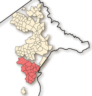
. It comprises 19 suburbs with a total of 31,819 dwellings, housing 87,119 people of the 324,034 people in the Australian Capital Territory
Australian Capital Territory
The Australian Capital Territory, often abbreviated ACT, is the capital territory of the Commonwealth of Australia and is the smallest self-governing internal territory...
(2006 Census
Census
A census is the procedure of systematically acquiring and recording information about the members of a given population. It is a regularly occurring and official count of a particular population. The term is used mostly in connection with national population and housing censuses; other common...
). The district occupies 117 square kilometres to the east of the Murrumbidgee River
Murrumbidgee River
The Murrumbidgee River is a major river in the state of New South Wales, Australia, and the Australian Capital Territory . A major tributary of the Murray River, the Murrumbidgee flows in a west-northwesterly direction from the foot of Peppercorn Hill in the Fiery Range of the Snowy Mountains,...
. From the earliest colonial times, the plain extending south into the centre of the present-day territory was referred to as Tuggeranong. The name is derived from an Aboriginal expression meaning "cold plains".
History
Cave paintingCave painting
Cave paintings are paintings on cave walls and ceilings, and the term is used especially for those dating to prehistoric times. The earliest European cave paintings date to the Aurignacian, some 32,000 years ago. The purpose of the paleolithic cave paintings is not known...
s and Aboriginal
Indigenous Australians
Indigenous Australians are the original inhabitants of the Australian continent and nearby islands. The Aboriginal Indigenous Australians migrated from the Indian continent around 75,000 to 100,000 years ago....
artifacts discovered in the area confirm that the Tuggeranong region has been occupied by the original inhabitants, the Ngunnawal people
Ngunnawal people
The Ngunnawal people are the Indigenous Australian inhabitants whose traditional lands encompass much of the area now occupied by the city of Canberra, Australia and the surrounding Australian Capital Territory...
, for over 21,000 years. The first Europeans arrived in the Canberra
Canberra
Canberra is the capital city of Australia. With a population of over 345,000, it is Australia's largest inland city and the eighth-largest city overall. The city is located at the northern end of the Australian Capital Territory , south-west of Sydney, and north-east of Melbourne...
region in 1820 and a year later, a third expedition led by Charles Throsby
Charles Throsby
Charles Throsby was an Australian explorer, pioneer and parliamentarian. He opened up much new land beyond the Blue Mountains for colonial settlement. He was a grazier, and became a prominent member of New South Wales society.- Early life :...
reached the Murrumbidgee River
Murrumbidgee River
The Murrumbidgee River is a major river in the state of New South Wales, Australia, and the Australian Capital Territory . A major tributary of the Murray River, the Murrumbidgee flows in a west-northwesterly direction from the foot of Peppercorn Hill in the Fiery Range of the Snowy Mountains,...
near the present-day Pine Island
Pine Island (Canberra)
Pine Island Reserve is a reserve on the Murrumbidgee River where the river flows through the Canberra district of Tuggeranong, Australia.Pine Island is not a permanent island, but exists when the area floods...
and the valley now occupied by the Tuggeranong district. In 1823 Joseph Wild was employed by Brigade Major John Ovens and Captain Mark Currie to guide them to the Murrumbidgee. They travelled south along the river and named the area now known as Tuggeranong Isabella's Plain in honour of Governor Brisbane's
Thomas Brisbane
Major-General Sir Thomas Makdougall Brisbane, 1st Baronet GCH, GCB, FRS, FRSE was a British soldier, colonial Governor and astronomer.-Early life:...
infant daughter. Unable to cross the river near the current site of Tharwa
Tharwa, Australian Capital Territory
Tharwa is a small village within the Australian Capital Territory, south of Canberra, the capital city of Australia. At the 2006 census, Tharwa had a population of 109....
, they continued on to the Monaro Plains.
Allan Cunningham (botanist)
Allan Cunningham was an English botanist and explorer, primarily known for his travels in New South Wales to collect plants.- Early life :...
in 1824. Cunningham's reports verified that the region was suitable for grazing, and the settlement of the Limestone Plains
Limestone Plains
The Limestone Plains were broad, frost-hollow floodplains through which the Molonglo River flowed. Early settlers named this floodplain after the occasional small outcrops of limestone found on it. The Limestone Plains were the area Australia's capital city Canberra was built on...
followed immediately thereafter.
In 1828, the bushranger
Bushranger
Bushrangers, or bush rangers, originally referred to runaway convicts in the early years of the British settlement of Australia who had the survival skills necessary to use the Australian bush as a refuge to hide from the authorities...
John Tennant
John Tennant
John Tennant was an Australian bushranger who was active around the Canberra district in the 1820s. Mount Tennent is named after him as it was on the slopes of this steep mountain behind the village of Tharwa where he would hide....
, known as the 'Terror of Argyle', was captured by James Ainslie
James Ainslie (pastoralist)
James Ainslie was a Scottish pastoralist, best known as the first overseer of the property known as Duntroon in the Australian Capital Territory, he increased the size of the property's sheep flock from 700 to 20,000 in 12 years. He lived in a relationship with an Aboriginal woman and she bore him...
and two others near the Murrumbidgee River in Tuggeranong. Tennant had been a convict assigned to Joshua John Moore
Joshua John Moore
Joshua John Moore , a grazier and large owner of land by occupation, was born to John Moore, yeoman farmer, at Horningsea, Cambridgeshire, England....
at Canberry, a property in the present day inner north Canberra
North Canberra
North Canberra, also known as the Inner North, is a district of Canberra, the capital city of Australia, comprising 14 suburbs with 19,115 dwellings housing 42,113 people of the 324,034 people in the Australian Capital Territory...
. Mount Tennent
Mount Tennent
Mount Tennent is a mountain in the southern part of the Australian Capital Territory. At the base of the mountain flows the Gudgenby River and this is a site for the proposed Mount Tennent Dam....
, behind Tharwa, is named after the bushranger (note the difference in spelling).
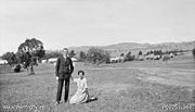
The first authorised settler was James Murdoch. In 1824 he was offered a land grant on a small plain known by the natives as 'Togranong' meaning 'cold plains'. He took up the grant in 1827. Lanyon station
Lanyon Homestead
Lanyon is an historic homestead and grazing property located on the southern outskirts of Canberra in the Australian Capital Territory.-History:...
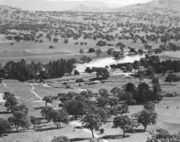
was established in 1835 and originally owned by James Wright and John Lanyon. Wright bought the property from Lanyon, who had only remained in Australia for three years. Wright sold to the Cunningham family in 1848. In 1835 Colonel Thomas Hiah Macquoid, then Sheriff of the New South Wales Supreme Court bought Tuggeranong station
Tuggeranong Homestead
Tuggeranong Homestead is located in the Australian Capital Territory in the area now covered by the suburb of Richardson.The first authorised landowner of the Tuggeranong area following white settlement was Peter Murdoch, aide-de-camp of Thomas Brisbane, who was awarded a grant of 2,000 acres in...
then known as Waniassa property (sic). The rural depression of 1840 hit hard and Macquoid committed suicide in order to avoid bankruptcy. His son took over the estate and creditors allowed him to continue to operate it until it was sold by the Macquoid family in 1858 to the Cunningham family, owners of the neighbouring Lanyon property. They renamed Waniassa to Tuggranong. The whole area was part of the Tuggeranong parish
Tuggeranong Parish, Murray
Tuggeranong Parish, Murray County is a parish of Murray County, New South Wales, a cadastral unit for use on land titles. It is now about a third of the size it was in the nineteenth century, after most of the land in the parish was transferred to the Australian Capital Territory in 1911...
in the late nineteenth century. Tuggranong homestead was rebuilt by the Cunningham family in 1908. In 1917 it was resumed by the Commonwealth Government for military purposes. The Cunningham family remained at Lanyon until 1926. Charles Bean
Charles Bean
Charles Edwin Woodrow Bean , usually identified as C.E.W. Bean, was an Australian schoolmaster, judge's associate, barrister journalist, war correspondent and historian....
, together with his staff, wrote the first two volumes of the twelve volume official history of Australia's involvement in World War I
Official History of Australia in the War of 1914-1918
The Official History of Australia in the War of 1914-1918 is a 12-volume series covering Australian involvement in the First World War. The series was edited by C.E.W. Bean, who also wrote six of the volumes, and was published between 1920 and 1942...
at the homestead from 1919 to 1925. The Tuggeranong property was leased as a grazing property by the McCormack family from 1927 to 1976.
In 1973, the third of the new towns planned for Canberra was inaugurated at Tuggeranong on 21 February. It was originally planned to house between 180,000 to 220,000 people. Planning for the new town had begun in 1969. The first families moved in to the suburb of Kambah
Kambah, Australian Capital Territory
Kambah is the northernmost suburb in the district of Tuggeranong, Canberra. It is located just south of the Mount Taylor in the Canberra Nature Park. It is located north of the suburbs of Greenway and Wanniassa...
in 1974.
The fifth Canberra fire station opened at Kambah in 1979 to service the new developing satellite city.
On December 1, 2011, Tuggeranong made history and became the first place in the world to sell Mario Kart 7, two days before it's official Australian release date. A Target employee who is apparently a "big Mario Kart fan" was at the heart of it all. Millions of Nintendo fans now look to Tuggeranong as a place of inspiration and where dreams become reality. Tourism is expected to pick up drastically and worldwide Mario Kart competitions are already being planned.
Urban structure
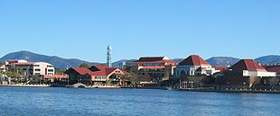
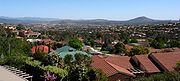
Lake Tuggeranong
Lake Tuggeranong is an artificial lake in the Canberra district of Tuggeranong. The lake was created by the construction of a dam in 1987 coinciding with urban development in the district. The lake was built as a sediment trap to stop sediment from entering the Murrumbidgee River.The lake is a...
which was created by the construction of a dam on a tributary of the Murrumbidgee river in 1987. On the edge of the lake are a number of community facilities, including Lake Tuggeranong College
Lake Tuggeranong College
Lake Tuggeranong College is an Australian Capital Territory public school catering to Year 11 and 12 students . It is located in the Tuggeranong, Canberra, close to Tuggeranong Town Centre and on the shores of Lake Tuggeranong in Greenway. The current principal is Dr...
, a school catering to years 11 and 12 (16 – 18 years old); a Library, which is part of ACT Library and Information Services, a Community Centre, two fast food outlets, and the Tuggeranong Arts Centre
Tuggeranong Arts Centre
Tuggeranong Arts Centre is a purpose-built centre located on the shores of Lake Tuggeranong, in the town centre of Tuggeranong, a southern suburb of Canberra, Australian Capital Territory. It is an organisation providing a wide range of arts activities for community participation, development and...
.
The Tuggeranong Town Centre
Tuggeranong Town Centre
Tuggeranong Town Centre services the southernmost Canberra district of Tuggeranong. It is located on the south-western side of Lake Tuggeranong and composed of a large three-storey mall, the Tuggeranong Hyperdome, as well as a smaller shopping complex, the Homeworld, and many other buildings and...
is to the west of the lake. It includes a major shopping centre, known as the Tuggeranong Hyperdome
Tuggeranong Hyperdome
The Tuggeranong Hyperdome is a two-storey regional shopping centre located in Greenway, Australian Capital Territory, servicing the district of Tuggeranong.-Ownership:...
(referring to the architectural use of semi-opaque domes in the roof) or by the newer name Centro Tuggeranong Hyperdome. Centro Tuggeranong Hyperdome is managed, developed and part owned by Centro Properties Group
Centro Properties Group
Centro Properties Group, commonly known as 'Centro', is an Australian company which provides retail property ownership and management services. It is a listed company with securities traded on the Australian Securities Exchange. The multinational company owns and operates shopping centres in...
. It is surrounded by offices of the Australian and ACT Governments, and a light industrial area.
Places of interest
- Tuggeranong Arts CentreTuggeranong Arts CentreTuggeranong Arts Centre is a purpose-built centre located on the shores of Lake Tuggeranong, in the town centre of Tuggeranong, a southern suburb of Canberra, Australian Capital Territory. It is an organisation providing a wide range of arts activities for community participation, development and...
- a community facility including workshops, gallery, dance studio and theatre. - Tuggeranong HillTuggeranong HillTuggeranong Hill is located in Tuggeranong, Canberra. It is sometimes referred to as Mount Tuggeranong due to its prominence.Lanyon Valley is almost completely surrounded by hills and mountains and consequently television transmissions from Black Mountain are affected. To overcome this, there is a...
- a large mountainMountainImage:Himalaya_annotated.jpg|thumb|right|The Himalayan mountain range with Mount Everestrect 58 14 160 49 Chomo Lonzorect 200 28 335 52 Makalurect 378 24 566 45 Mount Everestrect 188 581 920 656 Tibetan Plateaurect 250 406 340 427 Rong River...
overlooking the valley. - Lanyon HomesteadLanyon HomesteadLanyon is an historic homestead and grazing property located on the southern outskirts of Canberra in the Australian Capital Territory.-History:...
- a historic grazing property that also has the Nolan Gallery - Tuggeranong HomesteadTuggeranong HomesteadTuggeranong Homestead is located in the Australian Capital Territory in the area now covered by the suburb of Richardson.The first authorised landowner of the Tuggeranong area following white settlement was Peter Murdoch, aide-de-camp of Thomas Brisbane, who was awarded a grant of 2,000 acres in...
- a historic homestead now operated as a caféCaféA café , also spelled cafe, in most countries refers to an establishment which focuses on serving coffee, like an American coffeehouse. In the United States, it may refer to an informal restaurant, offering a range of hot meals and made-to-order sandwiches...
and function or event centre. - Centro Tuggeranong Hyperdome - large regional shopping centre
- Tuggeranong Town CentreTuggeranong Town CentreTuggeranong Town Centre services the southernmost Canberra district of Tuggeranong. It is located on the south-western side of Lake Tuggeranong and composed of a large three-storey mall, the Tuggeranong Hyperdome, as well as a smaller shopping complex, the Homeworld, and many other buildings and...
- the town centre - Tuggeranong Hometown - the hometown of the late Craig Shotland
Suburbs
| Suburb | Population (in 2006) |
Median age (in 2001) |
Mean household size (in 2001) |
Area (km²) |
Density (/km²) |
Date first settled as a suburb |
Gazetted as a Division Name |
Median property prices 2005 _ |
|---|---|---|---|---|---|---|---|---|
| Banks Banks, Australian Capital Territory Banks is a suburb in the Canberra, Australia district of Tuggeranong. It is the most southerly suburb of Canberra. The suburb is named after Sir Joseph Banks , the botanist who accompanied Captain James Cook to the Pacific Ocean on which he entered Botany Bay in 1770. The suburb was gazetted on 12... |
4,907 |
28 years | 2.8 persons | 2.24 | 1,619 | 1992 | 12 March 1987 | $308,000 _ |
| Bonython Bonython, Australian Capital Territory Bonython is a suburb of Tuggeranong, a township in southern Canberra, capital city of Australia.-History:The suburb is named after Sir John Langdon Bonython, the owner of The Advertiser who promoted Federation, and was a member of the first Australian parliament. Original concept plans for... |
3,363 |
30 years | 2.9 persons | 2.90 | 1,200 | 1989 | 17 October 1986 | $346,000 _ |
| Calwell Calwell, Australian Capital Territory Calwell is a medium sized suburb of Canberra, Australia in the district of Tuggeranong. Tuggeranong Hill is on its southern border and the Tuggeranong Homestead is to the north... |
5,929 |
30 years | 3 persons | 3.87 | 1,560 | 1986 | 5 August 1975 | $310,000 _ |
| Chisholm Chisholm, Australian Capital Territory Chisholm is a suburb in the Canberra, Australia district of Tuggeranong, named after Caroline Chisholm.It was gazetted on 5 August 1975, and streets are named after notable women.... |
5,378 |
29 years | 3.1 persons | 3.11 | 1,823 | 1982 | 5 August 1975 | $305,000 _ |
| Conder Conder, Australian Capital Territory Conder is one of three suburbs in the Lanyon Valley in Canberra, Australia. It lies in the district of Tuggeranong. The three suburbs are presently the southernmost suburbs of the city, although the small settlement of Tharwa exists only a short distance further south.Named after artist Charles... - Lanyon Market Place Lanyon Market Place Lanyon Marketplace is a group centre in district of Tuggeranong in the city of Canberra. The centre primarily services the Lanyon Valley at the southern end of Tuggeranong, consisting of the suburbs of Conder, Gordon and Banks; the centre also services other suburbs to the north and Tharwa to the... |
5,051 |
28 years | 3.2 persons | 4.51 | 966 | 1991 | 12 March 1987 | $300,000 _ |
| Fadden Fadden, Australian Capital Territory Fadden is a suburb in the Canberra, Australia district of Tuggeranong. The postcode is 2904. The suburb is named after Sir Arthur Fadden, Prime Minister of Australia briefly in 1941. It was gazetted on 5 August 1975. Its streets are named after Queensland politicians... |
3,215 |
35 years | 3.3 persons | 3.11 | 1,064 | 1981 | 5 August 1975 | $480,000 _ |
| Gilmore Gilmore, Australian Capital Territory Gilmore is a suburb in the Canberra, Australia district of Tuggeranong. The postcode is 2905. The suburb is named after the poet and journalist, Dame Mary Gilmore. It was gazetted on 5 August 1975... |
2,905 |
28 years | 3.3 persons | 2.10 | 1,415 | 1985 | 5 August 1975 | $325,000 _ |
| Gordon Gordon, Australian Capital Territory Gordon is a suburb in the Canberra, Australia district of Tuggeranong. The postcode is 2906. The suburb is named after the poet Adam Lindsay Gordon . It was gazetted on 12 March 1987... |
7,869 |
29 years | 3 persons | 4.47 | 1,667 | 1990 | 12 March 1987 | $300,000 _ |
| Gowrie Gowrie, Australian Capital Territory Gowrie is a suburb of Canberra, Australia, located in the northern end of the Tuggeranong Valley. Tuggeranong suburbs are the southernmost of Australia's capital city... |
3,226 |
31 years | 3.1 persons | 1.93 | 1,702 | 1981 | 5 August 1975 | $352,000 _ |
| Greenway Greenway, Australian Capital Territory Greenway is a suburb in the Canberra, Australia district of Tuggeranong. The postcode is 2900. The suburb is named after the architect, Francis Greenway . It was gazetted on 17 October 1986. The streets are named after architects... - Tuggeranong Town Centre Tuggeranong Town Centre Tuggeranong Town Centre services the southernmost Canberra district of Tuggeranong. It is located on the south-western side of Lake Tuggeranong and composed of a large three-storey mall, the Tuggeranong Hyperdome, as well as a smaller shopping complex, the Homeworld, and many other buildings and... |
1,129 | 34 years | 2.2 persons | 5.35 | 181 | 1988 | 17 October 1986 | $408,000 _ |
| Hume Hume, Australian Capital Territory Hume is a suburb of Canberra in the district of Tuggeranong. The suburb is named after the explorer Hamilton Hume and streets are named after Australian industrialists and businessmen. Hume is a light-industrial suburb and there is no significant housing development... |
6 |
~ | ~ | 8.80 | ~ | 22 March 1982 | $292,000 _ | |
| Isabella Plains Isabella Plains, Australian Capital Territory Isabella Plains is a suburb in the Canberra, Australia district of Tuggeranong. The postcode is 2905. The suburb is indirectly named after Isabella Maria Brisbane , who was the daughter of Thomas Brisbane the colonial Governor of New South Wales when the area was first explored by white settlers... |
4,317 | 29 years | 2.9 persons | 2.49 | 1,761 | 1985 | 5 August 1975 | $295,000 _ |
| Kambah Kambah, Australian Capital Territory Kambah is the northernmost suburb in the district of Tuggeranong, Canberra. It is located just south of the Mount Taylor in the Canberra Nature Park. It is located north of the suburbs of Greenway and Wanniassa... - Kambah Village Centre |
15,579 |
33 years | 2.8 persons | 11.30 | 1,428 | 1974 | 22 March 1973 | $310,000 _ |
| Macarthur Macarthur, Australian Capital Territory Macarthur is a suburb in the Canberra district of Tuggeranong. The suburb is named after John Macarthur, one of the founders of Australia's Merino wool industry. It was gazetted on 22 March 1982 and first settled in 1983. The wool industry is the theme for street names. The suburb has an area of... |
1,582 |
32 years | 3.3 persons | 1.27 | 1,251 | 1983 | 22 March 1982 | $375,000 _ |
| Monash Monash, Australian Capital Territory Monash is a suburb in the district of Tuggeranong, Canberra, Australia. The suburb is named after General Sir John Monash, , who commanded the Australian Army in France in the First World War. It was gazetted on 1 August 1975 and first settled in 1978. The suburb has an area of 3.41 km²... |
5,550 |
32 years | 3 persons | 3.41 | 1,688 | 1978 | 5 August 1975 | $332,000 _ |
| Oxley Oxley, Australian Capital Territory Oxley is the smallest suburb in Canberra. It is located in the district of Tuggeranong. The suburb is named after the explorer John Joseph William Molesworth Oxley , who explored parts of New South Wales. It was gazetted on 22 March 1982 and first settled in 1985... |
1,788 |
31 years | 3 persons | 1.08 | 1,700 | 1985 | 22 March 1982 | $366,000 _ |
| Richardson Richardson, Australian Capital Territory Richardson is a suburb in the Canberra, Australia, district of Tuggeranong. The postcode is 2905. The suburb is named after the author Henry Handel Richardson, nom de plume of Ethel Florence Lindesay Richardson . It was gazetted on 5 May 1975. Streets are named after writers, especially female... |
3,233 |
29 years | 3 persons | 2.24 | 1,493 | 1981 | 5 May 1975 | $278,000 _ |
| Theodore Theodore, Australian Capital Territory Theodore is a suburb in the Canberra, Australia district of Tuggeranong. The postcode is 2905. The suburb is named after Edward Glanville Theodore , a Queensland premier and deputy Prime Minister. It was gazetted on 5 August 1975. Streets are named after people involved with the civilian war... |
4,109 |
28 years | 3.1 persons | 3.13 | 1,330 | 1986 | 5 August 1975 | $303,000 _ |
| Wanniassa Wanniassa, Australian Capital Territory Wanniassa is a suburb in the Canberra, Australia district of Tuggeranong. It is located towards the north of the district. The suburb takes its name from a pastoral property granted to Thomas McQuoid in 1835, which he named after Wanajassa in West Java, Indonesia, where McQuoid had previously... - Erindale Centre Erindale Centre The Erindale Centre is a designated group centre located in the Canberra suburb of Wanniassa. It stands on the former site of the Erindale Homestead for which it is named, and serves the suburbs of Wanniassa, Monash, Gowrie, Fadden and Oxley... |
7,933 |
33 years | 2.9 persons | 5.43 | 1,513 | 1975 | 21 May 1974 | $330,000 _ |
External links
- Tuggeranong suburbs map - links to ACT Government street-level maps.
- Canberra region map - all districts
- Australian Bureau of Statistics
- Tuggeranong Homestead
- Lanyon Homestead
- Nolan Gallery
- Google Maps Satellite Image of Tuggeranong