

Seat of Government Acceptance Act 1909
Encyclopedia
The Seat of Government Acceptance Act 1909 is an Australia
n Commonwealth Government
act, that in conjunction with the Seat of Government Surrender Act 1909
transferred land from the state of New South Wales
to the Commonwealth for the creation of the Federal Capital Territory (now Australian Capital Territory
).
The act was signed on 13 December 1909 by the Governor-General
Lord Dudley
. The Seat of Government Surrender Act 1909
was passed by the New South Wales government the following day, creating a site for the national capital in law.
 The act specified the land to be surrendered to the Commonwealth as being bounded by (described in clockwise direction):
, which became the Jervis Bay Territory
in 1915:
Australia
Australia , officially the Commonwealth of Australia, is a country in the Southern Hemisphere comprising the mainland of the Australian continent, the island of Tasmania, and numerous smaller islands in the Indian and Pacific Oceans. It is the world's sixth-largest country by total area...
n Commonwealth Government
Government of Australia
The Commonwealth of Australia is a federal constitutional monarchy under a parliamentary democracy. The Commonwealth of Australia was formed in 1901 as a result of an agreement among six self-governing British colonies, which became the six states...
act, that in conjunction with the Seat of Government Surrender Act 1909
Seat of Government Surrender Act 1909
The Seat of Government Surrender Act 1909 was an Act of the New South Wales Parliament which completed the transfer of land from New South Wales to establish the Federal Capital Territory as the seat of Commonwealth government...
transferred land from the state of New South Wales
New South Wales
New South Wales is a state of :Australia, located in the east of the country. It is bordered by Queensland, Victoria and South Australia to the north, south and west respectively. To the east, the state is bordered by the Tasman Sea, which forms part of the Pacific Ocean. New South Wales...
to the Commonwealth for the creation of the Federal Capital Territory (now Australian Capital Territory
Australian Capital Territory
The Australian Capital Territory, often abbreviated ACT, is the capital territory of the Commonwealth of Australia and is the smallest self-governing internal territory...
).
The act was signed on 13 December 1909 by the Governor-General
Governor-General of Australia
The Governor-General of the Commonwealth of Australia is the representative in Australia at federal/national level of the Australian monarch . He or she exercises the supreme executive power of the Commonwealth...
Lord Dudley
William Ward, 2nd Earl of Dudley
William Humble Ward, 2nd Earl of Dudley, KP, GCB, GCMG, GCVO, KStJ, PC, TD, DL , styled Viscount Ednam before 1885, was a British Conservative politician...
. The Seat of Government Surrender Act 1909
Seat of Government Surrender Act 1909
The Seat of Government Surrender Act 1909 was an Act of the New South Wales Parliament which completed the transfer of land from New South Wales to establish the Federal Capital Territory as the seat of Commonwealth government...
was passed by the New South Wales government the following day, creating a site for the national capital in law.
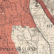
Boundaries
- The Goulburn to Cooma railway line in the east,
- Part of the Parish of Keewong in the County of MurrayMurray County, New South WalesMurray County was one of the original Nineteen Counties in New South Wales and is now one of the 141 Lands administrative divisions of New South Wales. It included the area which is now part of Canberra and as far north as Lake George and Yass. It was originally bounded on the west by the...
to the Murrumbidgee RiverMurrumbidgee RiverThe Murrumbidgee River is a major river in the state of New South Wales, Australia, and the Australian Capital Territory . A major tributary of the Murray River, the Murrumbidgee flows in a west-northwesterly direction from the foot of Peppercorn Hill in the Fiery Range of the Snowy Mountains,...
, down the river a short distance (to the north), and then portions of the Parish of Cuppacumbalong in the County of CowleyCowley County, New South WalesCowley County is one of the 141 Cadastral divisions of New South Wales. It contains the locality of Cavan. It was originally bordered on the north, east and part of the south by the Murrumbidgee River, and on the west by the Goodradigbee River...
. - The eastern watershed of the Gudgenby RiverGudgenby RiverThe Gudgenby River is a river in the Australian Capital Territory that flows predominantly through the forests of the Namadgi National Park. The river catchment contains ecologically significant alpine wetlands...
- The eastern and southern watersheds of Naas Creek
- The southern and western watersheds of the Cotter RiverCotter RiverThe Cotter River is a fresh water river in the Australian Capital Territory. It is a tributary of the Murrumbidgee River and part of Murray-Darling Basin. The Cotter River is one of two rivers—the Queanbeyan River is the other—that meet the water supply needs of the Canberra and...
(which passes through Bimberi PeakBimberi PeakBimberi Peak or Mount Bimberi is the highest mountain in the Australian Capital Territory at 1912 metres. It is located on the border between New South Wales and the ACT, the NSW portion in Kosciuszko National Park and the ACT portion in Namadgi National Park...
), and north to Mount CoreeMount CoreeMount Coree is a mountain located on the border between the Australian Capital Territory and New South Wales, Australia. It is located in Brindabella National Park on the NSW side, and Namadgi National Park on the ACT side. It has an elevation of 1421 metres... - A line north-east from Mount Coree to One-Tree Trigonometrical Station
- The watershed of the Molonglo RiverMolonglo RiverThe Molonglo River rises on the western side of the Great Dividing Range of eastern Australia in the state of New South Wales. Its source is on the other side of the mountain range from where the Shoalhaven River rises, in Tallaganda state forest at ~1200 metres altitude...
south-east to where it meets the railway line.
Jervis Bay
The Act also described the territories to be granted to the Commonwealth in Jervis BayJervis Bay
Jervis Bay is a large bay bounded by the state of New South Wales, the Jervis Bay Territory, and a detached enclave of the Australian Capital Territory. HMAS Creswell is located between Jervis Bay Village and Greenpatch in the Jervis Bay Territory.-History:...
, which became the Jervis Bay Territory
Jervis Bay Territory
The Jervis Bay Territory is a territory of the Commonwealth of Australia. It was surrendered by the state of New South Wales to the Commonwealth Government in 1915 so that the Federal capital at Canberra would have "access to the sea"....
in 1915:
- Separate portions of land in the Eastern DivisionEastern Division (New South Wales)The Eastern Division of New South Wales is one of the three divisions of New South Wales along with the Central and Western divisions, established under the Crown Lands Act of 1884 for the purposes of land management. It is the most populated of the divisions, including Sydney and large coastal...
, Land District of Nowra, County of St. VincentSt. Vincent County, New South WalesSt Vincent County was one of the original Nineteen Counties in New South Wales and is now one of the 141 Cadastral divisions of New South Wales. It included the south coast area encompassing Batemans Bay, Ulladulla, Jervis Bay and inland to Braidwood. The Shoalhaven River is the boundary to the...
, in several different parishes: in the Parish of Bherwerre parcels of land of 2 mi2, 132 acre (0.53418552 km²), 412 acres (1.7 km²); in the Parish of Beecroft parcels of 520 acres (2.1 km²), 531 acres (2.1 km²), 424 acres (1.7 km²); in the Parish of Farnham 103 acre (0.41682658 km²); in the Parish of Nowra 180 acre (0.7284348 km²).