
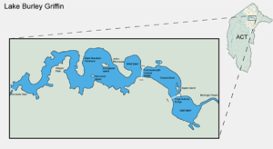
Lake Burley Griffin
Encyclopedia
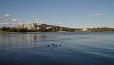
Lake Burley Griffin is an artificial lake in the centre of Canberra
, the capital of Australia
. It was completed in 1963 after the Molonglo River
—which ran between the city centre and Parliamentary Triangle—was dammed. It is named after Walter Burley Griffin
, the American architect who won the competition to design the city of Canberra.
Griffin designed the lake with many geometric motifs, so that the axes of his design lined up with natural geographical landmarks in the area. However, government authorities changed his original plans and no substantial work was completed before he left Australia in 1920. His scheme remained unfulfilled as the Great Depression
and World War II
intervened, and it was not until the 1950s that planning resumed. After much political dispute over several proposed variations, excavation work began in 1960 with the energetic backing of Prime Minister
Robert Menzies
. After the completion of the bridges and dams, the dams were locked in September 1963. However, a drought meant that the target water level was not reached until April 1964. It was formally inaugurated on 17 October 1964.
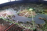
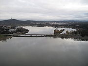
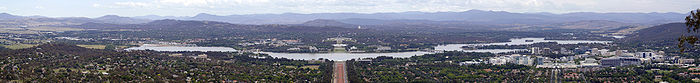
The lake is located in the approximate geographic centre of the city, and is the centrepiece of the capital in accordance with Griffin's original designs. Numerous important institutions, such as the National Gallery
, National Museum
, National Library
, Australian National University
and the High Court
were built on its shores, and Parliament House
is a short distance away. Its surrounds, consisting mainly of parklands, are popular with recreational users, particularly in the warmer months. Though swimming in the lake is uncommon, it is used for a wide variety of other activities, such as rowing, fishing, and sailing.
The lake is an ornamental body with a length of 11 kilometres (6.8 mi); at its widest, it measures 1.2 kilometre (0.745647283979768 mi). It has an average depth of 4 metres (13.1 ft) and a maximum depth of about 18 metres (59.1 ft) near the Scrivener Dam
. Its flow is regulated by the 33 metres (108.3 ft) tall Scrivener Dam, designed to handle floods that occur once in 5,000 years. In times of drought, water levels can be maintained through the release of water from Googong Dam, located on an upstream tributary of the Molonglo River.
 Charles Robert Scrivener
(1855–1923) recommended the site for Canberra in 1909, which was to be a planned capital city for the country. One of the reasons for the location's selection was its ability to store water "for ornamental purposes at reasonable cost"; Scrivener's work had demonstrated that the topography could be used to create a lake through flooding.
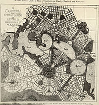
In 1911, a competition for the design of Canberra was launched, and Scrivener's detailed survey of the area was supplied to the competing architects. The Molonglo River
flowed through the site, which was a flood plain and Scrivener's survey showed in grey an area clearly representing an artificial lake—similar to the lake later created—and four possible locations for a dam to create it. Most of the proposals took the hint and included artificial bodies of water.
won the contest and was invited to Australia to oversee the construction of the nation's new capital after the judges' decision was ratified by King O'Malley
, the Minister for Home Affairs. Griffin's proposal, which had an abundance of geometric patterns, incorporated concentric hexagonal and octagonal streets emanating from several radii.
His lake design was at the heart of the city and consisted of a Central Basin in the shape of circular segment, a West and East Basin, which were both approximately circular, and a West and East Lake, which were much larger and irregularly shaped, at either side of the system. The East Lake was supposed to be 6 metres (19.7 ft) higher than the remaining components. Griffin's proposal was "the grandest scheme submitted, yet it had an appealing simplicity and clarity.
 The lakes were deliberately designed so that their orientation was related to various topographical landmarks in Canberra. The lakes stretched from east to west and divided the city in two; a land axis perpendicular to the central basin stretched from Capital Hill
—the future location of the new Parliament House
on a mound on the southern side—north northeast across the central basin to the northern banks along Anzac Parade
to the Australian War Memorial
(although a casino was originally planned in its place). This was designed so that looking from Capital Hill, the War Memorial stood directly at the foot of Mount Ainslie. At the southwestern end of the land axis was Bimberi Peak
.
The straight edge of the circular segment that formed the central basin was designated the water axis, and it extended northwest towards Black Mountain
, the highest point in Canberra. A line parallel to the water axis, on the northern side of the city, was designated the municipal axis. The municipal axis became the location of Constitution Avenue
, which linked City Hill
in Civic Centre and Market Centre. Commonwealth Avenue
and Kings Avenue
were to run from the southern side from Capital Hill to City Hill and Market Centre on the north respectively, and they formed the western and eastern edges of the central basin. The area enclosed by the three avenues was known as the Parliamentary Triangle, and was to form the centrepiece of Griffin's work.
 Later, Scrivener, as part of a government design committee, was responsible for modifying Griffin's winning design. He recommended changing the shape of the lake from Griffin's very geometric shapes to a much more organic one using a single dam, unlike Griffin's series of weir
s. Griffin lobbied for the retention of the pure geometry, saying that they were "one of the reasons d'etre of the ornamental waters", but he was overruled. The new design included elements from several of the best design submissions and was widely criticised as being ugly. The new plan for the lake retained Griffin's three formal basins: east, central, and west, though in a more relaxed form.
Griffin entered into correspondence with the government over the plan and its alternatives, and he was invited to Canberra to discuss the matter. Griffin arrived in August 1913 and was appointed Federal Capital Director of Design and Construction for three years.
The plans were varied again in the following years, but the design of Lake Burley Griffin remained based largely on the original committee's plan. It was later gazetted and legally protected by the federal parliament in 1926, based on a 1918 plan. However, Griffin had a strained working relationship with the Australian authorities and a lack of federal government funding meant that by the time he left in 1920, little significant work had been done on the city. A 1920s proposal to reduce West Lake into a ribbon of water was made on the basis of flood safety. However, the Owen and Peake report of 1929 ruled that the original design was hydrologically sound.
, followed by World War II
, development of the new capital was slow, and in the decade after the end of the war, Canberra was criticised for resembling a village, and its disorganised collection of buildings was deemed ugly. Canberra was often derisively described as "several suburbs in search of a city".
During this time, the Molonglo River flowed through the flood basin, with only a small fraction of the water envisaged in Griffin's plan. The centre of his capital city consisted of mostly farmland, with small settlements—mostly wooden, temporary and ad hoc—on either side. There was little evidence that Canberra was planned, and the lake and Parliamentary Triangle at the heart of Griffin's plan was but a paddock. Royal Canberra Golf Course, and Acton Racecourse and a sports ground were located on the pastoral land that was to become the West Lake, and people had to disperse the livestock before playing sport. A rubbish dump stood on the northern banks of the location of central basin, and no earth had been moved since Griffin's departure three decades earlier.
In 1950, the East Lake—the largest component—was eliminated upon the advice of the National Capital Planning and Development Committee (NCPDC). Today, what would have been the East Lake corresponds to the suburb of Fyshwick. The rationale given was that around 1700 acres (688 ha) of farmland would be submerged and that the Molonglo would have insufficient water to keep the lake filled.
In 1953, the NCPDC excised the West Lake from its plans and replaced it with a winding stream, which was 110 metres (360.9 ft) wide and covered around a fifth of the original area. As the NCPDC had only advisory powers, this change was attributed to the influence of senior officials in the Department of the Interior who felt that Griffin's plan was too grandiose. Advocates of watered-down scheme thought it was more economical and saved 350 hectares (864.9 acre) of land for development. However, according to engineering reports that were ignored, the smaller plan would actually cost more money and require a more complicated structure of dams that would in any case be less able to prevent flooding.
Initially, there was little opposition during the consultation period before the alterations were made. However, opposition to the reduction of the water area grew. The process that resulted in the alteration was criticised for being non-transparent and sneaky. Some organisations complained that they were not given an opportunity to express their opinion before the change was gazetted, and many politicians and the chief town planner were not informed. Critics bitterly insinuated that politically influential members of the Royal Canberra Golf Club
, whose course was situated on the location of the proposed West Lake, were responsible for the change in policy.
The Parliamentary Public Works Committee advised the Parliament to restore the West Lake. After an inquiry in late 1954, it concluded that:
The Prime Minister
, Robert Menzies
, regarded the state of the national capital as an embarrassment. Over time his attitude changed from one of contempt to that of championing its development. He fired two ministers charged with the development of the city, feeling that their performance lacked intensity.
In 1958, the newly created National Capital Development Commission
(NCDC), which had been created and given more power by Menzies following a 1955 Senate inquiry, restored the West Lake to its plans, and it was formally gazetted in October 1959. The NCDC also blocked a plan by the Department of Works to build a bridge across the lake along the land axis between Parliament House and the War Memorial contrary to Griffin's plans.
A powerful Senate Select Committee oversaw the NCDC and renowned British architect Sir William Holford was brought in to fine-tune Griffin's original plans. He changed the central basin's geometry so that it was no longer a segment of circle; he converted the southern straight edge into a polygonal shape with three edges and inserted a gulf on the northern shore. The result was closer to Scrivener's modified design some decades earlier.
The lake is relatively shallow; the maximum depth is 17.6 metres (57.7 ft) near the Scrivener Dam, and the average depth is 4 metres (13.1 ft). The shallowest part of the complex in the East Basin, which has an average depth of 1.9 metres (6.2 ft). The minimum depth of the water at the walls is around 0.5 metres (1.6 ft) and rock is placed at the toe of the wall to inhibit aquatic plant growth.
Lake Burley Griffin contains six islands, three unnamed small islands and three larger named islands. Of the larger islands, Aspen Island
is located in Central Basin while Springbank
and Spinnaker
Island are located in the West Lake. Aspen Island is connected to dry land by a footbridge, and is the site of the Australian National Carillon.
In February 1959, formal authority for beginning construction was granted. However, while Menzies was on holidays, some officials from the Department of Treasury convinced ministers to withhold money needed for the lake, so the start of the construction was delayed. Once it started, progress was fast. At its peak, the number of people physically working on the construction in the lakes was between 400 and 500. John Overall
, the Commissioner of the NCDC, promised Menzies that the work would be finished within four years, and he succeeded, despite the Prime Minister's scepticism. Equipment was quickly requisitioned.
After the lengthy political wrangling over the design had passed, the criticism of the scheme died down. Menzies strongly denounced the "moaning" by opponents of the lake. Most critics decried the project as a waste of money that should have been spent on essential services across Australia. Less strident concerns centred on the potentially negative effects of the lake, such as mosquitoes, ecological degeneration, siltation and the possibility that the lake would create fog. The latter of these concerns has proven to be unfounded.
 The excavation of Lake Burley Griffin began in 1960 with the clearing of vegetation from the floodplain of the Molonglo River. The trees on the golf course and along the river were pulled up, along with the various sports grounds and houses.
During major earthworks, at least 382000 cubic metres (499,637.1 cu yd) of topsoil was excavated. It was collected for use at several public parks and gardens, including the future Commonwealth Park on the northern shore. It was also used to create the six artificial islands including Springbank Island. The island was named after the former Springbank Farm that was situated there. Land excavated to create a sailing course at Yarralumla
was used for the thematically named Spinnaker Island to its north, while excavated stone was moved beside the Kings Avenue Bridge at the eastern edge of the central basin from Aspen Island.
Care was taken to excavate the entire lake floor to a depth of at least 2 metres (6.6 ft) to provide sufficient clearance for boat keels. Another reason given for this was that mosquitoes would not breed nor would weeds grow at such a depth. A soil conservation program was launched in the catchment and bed load traps were installed to minimise loss of earth. The traps have been used as a source of sand and gravel for building sites. Drainage blankets were used to prevent the loss of groundwater
beneath the lake.
During the following phase of work, four types of lake margin were constructed. On the southern side of the Central Basin, low reinforced concrete retaining walls were used, while on the eastern side, grouted rock wall can be seen near Commonwealth Park, as well as much of the East Basin. Sand and gravel beaches were built to cater for lakeside recreational pursuits. These are mostly prevalent on the western half of the lake complex. Rocky outcrops, steeply sloping stable shores with water vegetation such as bullrushes were also used. This treatment is evident in the West Lake in Yarralumla. William Holford and Partners were responsible for the foreshore landscaping, and over 55,000 trees were planted in accordance with a detailed scheme. Eucalypt
s were preferred so as to maintain the natural colour of the city landscape.
Bridge (310 metres (1,017.1 ft)), Kings Avenue
Bridge (270 metres (885.8 ft)) and a roadway over Scrivener Dam
. The two bridges were constructed before the lake was filled, and replaced wooden structures.
 Site testing for both the Commonwealth Avenue and Kings Avenue bridges took place during late 1959 to early 1960. The construction of the Kings Avenue Bridge began in 1960, followed by Commonwealth Avenue Bridge the year after. Fortunately for the builders, Canberra was in a drought and the ground remained dry during construction. Both bridges use post-tensioned concrete, reinforced with rustproof steel cables.
Both bridges are made of concrete and steel and are dual-carriageway; Commonwealth Avenue has three lanes in each direction while Kings Avenue has two. Instead of traditional lamp post lighting, Kings Avenue Bridge was illuminated by a series of fluorescent tubes on the handrails, a concept known as "integral lighting". The design was deemed a success, so it was introduced to the Commonwealth Avenue Bridge also. Both structures won awards from the Illumination Engineering Society.
Kings Avenue Bridge opened on 10 March 1962. Prime Minister Menzies unlocked a ceremonial chain before the motorcade and pageant crossed the lake in front of a large crowd. Commonwealth Avenue Bridge opened in 1963 without an official ceremony. Menzies called it "the finest building in the national capital".
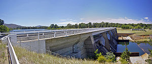 The dam that holds back the waters of Lake Burley Griffin was named Scrivener Dam
after Charles Robert Scrivener
. The dam was designed and built by Rheinstahl Union Bruckenbau in West Germany
, and utilised state-of-the-art post-tensioning techniques to cope with any problems or movements in the riverbed. This was required because of the quartz porphery and geological faulting upon which the dam sits. About 55000 cubic metres (71,937.3 cu yd) of concrete was used in its construction. The dam is 33 metres (108.3 ft) high and 319 metres (1,046.6 ft) long with a maximum wall thickness of 19.7 metres (64.6 ft). The dam is designed to handle a once in 5,000 year flood event. Construction began in September 1960 and the dam was locked in September 1963.
The dam has five bay spillway
controlled by 30.5 metres (100.1 ft) wide, hydraulically
operated fish-belly flap gates. The fish-belly gates allow for a precise control of water level, reducing the dead area on the banks between high and low water levels. The five gates have only been opened simultaneously once in the dam's history, during heavy flooding in 1976. The gates hold two thirds of the lake's volume. They were designed to allow easy flow of debris out of the lake.
The dam has the capacity to allow a flow of 5600 m3/s but can withstand up to 8600 m3/s before "catastrophic damage" results; A flow of 2830 m3/s can be dealt with without any substantial change in the water level. The highest recorded flow in the Molonglo was 3400 m3/s during an earlier flood.
Lady Denman Drive, a roadway atop the dam wall, provides a third road crossing for the lake. It consists of a roadway and a bicycle path, and allows residents in western Canberra to cross the lake. This was possible because the dam gates are closed by pushing up from below, unlike most previous designs that wherein the gates were lifted from above.
; Menzies was absent due to ill health. Several months on, with no rain in sight, mosquito-infested pools of water were the only visible sign of the lake filling. With the eventual breaking of the drought, the lake reached the planned level on 29 April 1964. On 17 October 1964, Menzies (by now Sir Robert) commemorated the filling of the lake and the completion of stage one with an opening ceremony amid the backdrop of sailing craft. The ceremony was accompanied by fireworks display, and Griffin's lake had finally come to fruition after five decades, at the cost of AUD5,039,050. Freeth suggested that Menzies had "been in a material sense the father of the lake" and that the lake should be named after him. Menzies insisted that the lake should be named after Griffin.
In times of severe drought, Lake Burley Griffin's water level can fall unacceptably low. When this happens, a release of water from Googong Dam located upstream can be scheduled to top up and restore the lake water level. The Googong Dam is located on the Queanbeyan River
which is a tributary of the Molonglo River. The dam whose construction was finished in 1979 is one of three dams—the Cotter and Corin Dams are the others—that meet the water supply needs of the Canberra and Queanbeyan
region. The Googong Dam's water carrying capacity is 124500000 cubic metre.
 Griffin's design made the lake a focal point of the city. In the four decades since the initial construction of the lake, various buildings of national importance were added. According to the policy plan of the government, "The lake is not only one of the centrepieces of Canberra's plan in its own right, but forms the immediate foreground of the National Parliamentary Area."
The creation of the lake also gave a water frontage to many prominent institutions that were previously landlocked. The Royal Canberra Hospital
was located on the Acton Peninsula
between the West Lake and the West Basin on the north shore until its demolition. Government House
, the historic Blundell's Cottage
—which was built over 50 years before construction of Canberra began—and the newly built Australian National University
, on the southern and northern shores of the West Lake, both gained a waterfront.
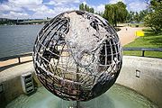
In 1970, two tourist attractions were added to the middle of Central Basin. The Captain James Cook Memorial
was built by the government to commemorate the Bicentenary of (then Lieutenant) James Cook
's first sighting of the east coast of Australia. It includes a water jet fountain located in the central basin (based on the Jet d'eau
in Geneva) and a skeleton globe sculpture at Regatta Point showing the paths of Cook's expeditions. On 25 April 1970, Queen Elizabeth II
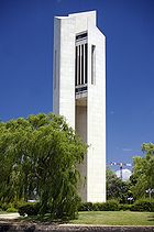
officially inaugurated the memorial. As part of the same ceremony, Queen Elizabeth also opened the National Carillon on Aspen Island, a set of 53 bronze bells donated by the British Government to commemorate the city's 50th anniversary.
 The completion of the central basin placed a waterway between Parliament House and the War Memorial and a landscaped boulevard was built along the land axis. Later, various buildings of national importance were built along the land axis in the late-1960s through to the early 1980s. The National Library
was opened on the western side of the axis in April 1968. Building of the High Court
and National Gallery
occurred in the late-1970s and the buildings were opened in May 1980 and October 1982 respectively. The latter two buildings lie on the eastern side of the axis and are connected by an aerial bridge. In 1988, the new Parliament House was built on Capital Hill, thereby completing the most important structure in the Parliamentary Triangle.
The current home of the National Museum
was built on the former site of the Royal Canberra Hospital in 2001. This occurred after the public were encouraged to watch the controlled demolition of the hospital
in 1997, but a girl was killed by flying debris, leading to criticism of the ACT Government.
At the start of the 21st century, the layout of the lake was significantly altered for the first time since its construction, through the Kingston Foreshores Redevelopment on southern shore of the East Basin, which was planned in 1997. A bidding process was enacted, multi-million dollar luxury apartment complexes were built in the suburb of Kingston
, driving property values to record-breaking levels. After a dispute over the environmental impact of the development, building works commenced on the previously industrial lakeside area of the suburb. In 2007, work started to reclaim land from the lakebed to form a harbour, which is expected to turn the area into an entertainment hub.
The Kingston Powerhouse
, which used to provide the city's power supply, was converted into the Canberra Glassworks
in 2007, 50 years after the electricity generators stopped. A 22 metres (72.2 ft) high tower of glass and light named Touching Lightly, will be built at Kingston after being approved by the government in April 2009. An environmentally friendly structure, it is expected to be completed in mid-2009.
In 2007, the government unveiled a proposal to redevelop the area surrounding the historic Albert Hall
into a tourist and dining precinct. This included the building of an eight-storey building and the rezoning of some waterfront land currently designated as cultural to commercial. It was met with widespread hostility from heritage activists and the general community, which submitted more than 3,300 signatories in a petition against the scheme. One of the criticisms was that the project was tilted too heavily towards business, and neglected the arts and community events. The proposal was scrapped in 2009.
It has been proposed that a footbridge, to be named Immigration Bridge
, be built between the National Museum of Australia
and Lennox Gardens on the south shore, in recognition of the contributions that immigrants have made to Australia. The proposal has mostly received negative feedback. An inquiry recommended that the bridge be redesigned or moved to accommodate the needs of other lake users.
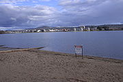
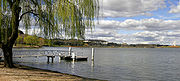
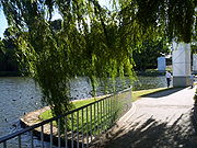 The surrounds of Lake Burley Griffin are very popular recreational areas. Public parks exist along most of the shore line, with free electric barbecue facilities, fenced-in swimming areas, picnic tables and toilets. These parklands form a large part of the area around the lake, and occupy 3.139 km² (775.7 acre) in total. Some of the parks reserved for public recreation include Commonwealth, Weston
, Kings
and Grevillea Parks, Lennox Gardens
and Commonwealth Place. Commonwealth and Kings Park on the northern shore of the Central Basin are among the two most popular. The former is an urban horticultural park and is the location of the Canberra Festival. Commonwealth Park is the location of Floriade, an annual flower festival that is held for around a month in spring and attracts upwards of 300,000 visitors, a number comparable to the city population. The largest flower festival in Australia, the event is a major tourist attraction for the city, and legal action was threatened after another festival in Australia wanted to use the same name. An expansion is being planned to coincide with the centenary of the national capital. The Weston Park to the west is known for its woodland and conifers, while Black Mountain Peninsula is known as a picnicking site with eucalypts. Grevillea and Bowen Parks on the East Basin tend to be little used.
Owing to the proliferation of beaches, boat ramps and jetties, the West Lake is the area most used by swimmers and vessels. A bike path also surrounds the lake, and riding, walking or jogging around the lake are a popular activity on the weekends. Fireworks are often held over the lake on New Year's Eve
, and a large show called Skyfire
has been held at the lake since 1988.
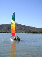
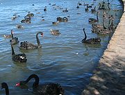 Lake Burley Griffin, apart from being ornamental, is used for many recreational activities. Canoeing, sailing, paddleboating and windsurfing are popular. A rowing course is set up at the western end of the lake. The National Championships were held in the lake in 1964, but high winds have deterred organisers. On one occasion, winds swept a boat into a bridge pylon. While not particularly popular, opportunities for swimming have been limited recently because of increasingly frequent lake closures due to concerns about water quality; another deterrent against swimming is the generally cold water temperature. During summer, the lake is used for the swim leg of numerous triathlon and aquathlon events including the Sri Chinmoy Triathlon Festival.
Generally, powerboat use on the lake is not permitted. Permits are available for the use of powered boats on the lake for use in rescue, training, commercial purposes or special interest (such as historic steam powered boats). Molonglo Reach, an area of the Molonglo River just before it enters the east basin is set aside for water skiing, although it is currently suspended due to a blue-green algae outbreak. Powerboats may be used in this limited area.
 The lake is patrolled by the Australian Federal Police
water police
. The water police give assistance to lake users, helping to right boats and towing crippled craft to shore.
At most swimming locations around Lake Burley Griffin there are fenced-in swimming areas for safety. In the more popular areas, there are also safety lockers with life belts and emergency phones for requesting help. Between 1962 and 1991, seven people died from drowning.
For safety and water quality reasons, the lake has different zones for different activities. The eastern extremity is zoned for primary contact water activities such as swimming and water skiing. The East and Central Basins, closer to populated areas, are zoned for secondary contact water sports such as sailing or rowing. West Lake and Tarcoola Reach, which covers the area between Commonwealth Avenue and Kurrajong Point, is the primary recreational area of the lake, and both primary and secondary contact water sports are permitted. Yarramundi Reach near Scrivener Dam has a marked rowing course, and is zoned as secondary, although primary contact activities are also allowed.
 Toxic blue-green algae blooms are a reasonably common occurrence in the lake. Warnings about coming into contact with the water are released when an algal bloom
is detected. Attempts are being made to limit the amount of phosphate
s entering the lake in the hope of improving its water quality. Blue-green algae (more correctly cyanobacteria) produce toxin
s, which can be harmful for humans and any other animals that come in contact with the contaminated water. There have been several cases of dogs being affected after playing in and drinking the lake water.
The water also appears murky due to a high level of turbidity
; however, this is not usually a health risk. However, the turbidity, which is caused by wind, prevents photosynthetic stabilisation. Siltation is not considered a major problem and is only a factor in the East Basin, but dredging is not required. The problem has eased with the construction of the Googong Dam, and the spectre of heavy metal pollution has receded, partly due to the closure of some lead mines upstream. However, leaching and groundwater leakage still causes some pollution. Rubbish, oil and sediment traps have been set up at the incoming openings to the lake to minimise pollution.
. Annual monitoring is carried out to determine fish populations. However, a number of less common species also inhabit the lake, including native Murray cod
, western carp gudgeon
and silver perch
, as well as introduced goldfish
, Gambusia
, rainbow trout
and brown trout
.
 The lake has been stocked annually with a variety of introduced and native species and over half a million fish have been released since 1981. There have been many changes to the fish populations in the lake as well as stocking practices since it was first filled.
Regular stocking since the start of the 1980s have re-established reasonable populations of golden perch and Murray cod; native fish that were indigenous to the Molonglo River before the lake was built, but had been lost to mining pollution of the Molonglo River in the first half of the 20th century. The main reason for stocking is to boost fish stocks along the Molonglo, which have been depleted by overfishing, introduced species and habitat destruction. One of the motives for raising the level of Murray cod and golden perch is to balance the ecosystem by having them act as native predators of other fish.
Silver perch and brown trout were released in 1981–83 and 1987–89 respectively, but have not been stocked since. Rainbow trout have been released sporadically, approximately once a decade, but have not been released since 2002–04, due to unacceptably low survival rates. According to a government report, the reason for the low survival rate is unknown, but the dominance of carp in the competition for food is one prominent theory. Golden perch and Murray cod have accounted for around four fifths of the released fish in the last three decades and have been the only fish stocked in the last five years. The government plans to stock only these two species for the five years leading up to 2014.
Canberra
Canberra is the capital city of Australia. With a population of over 345,000, it is Australia's largest inland city and the eighth-largest city overall. The city is located at the northern end of the Australian Capital Territory , south-west of Sydney, and north-east of Melbourne...
, the capital of Australia
Australia
Australia , officially the Commonwealth of Australia, is a country in the Southern Hemisphere comprising the mainland of the Australian continent, the island of Tasmania, and numerous smaller islands in the Indian and Pacific Oceans. It is the world's sixth-largest country by total area...
. It was completed in 1963 after the Molonglo River
Molonglo River
The Molonglo River rises on the western side of the Great Dividing Range of eastern Australia in the state of New South Wales. Its source is on the other side of the mountain range from where the Shoalhaven River rises, in Tallaganda state forest at ~1200 metres altitude...
—which ran between the city centre and Parliamentary Triangle—was dammed. It is named after Walter Burley Griffin
Walter Burley Griffin
Walter Burley Griffin was an American architect and landscape architect, who is best known for his role in designing Canberra, Australia's capital city...
, the American architect who won the competition to design the city of Canberra.
Griffin designed the lake with many geometric motifs, so that the axes of his design lined up with natural geographical landmarks in the area. However, government authorities changed his original plans and no substantial work was completed before he left Australia in 1920. His scheme remained unfulfilled as the Great Depression
Great Depression
The Great Depression was a severe worldwide economic depression in the decade preceding World War II. The timing of the Great Depression varied across nations, but in most countries it started in about 1929 and lasted until the late 1930s or early 1940s...
and World War II
World War II
World War II, or the Second World War , was a global conflict lasting from 1939 to 1945, involving most of the world's nations—including all of the great powers—eventually forming two opposing military alliances: the Allies and the Axis...
intervened, and it was not until the 1950s that planning resumed. After much political dispute over several proposed variations, excavation work began in 1960 with the energetic backing of Prime Minister
Prime Minister of Australia
The Prime Minister of the Commonwealth of Australia is the highest minister of the Crown, leader of the Cabinet and Head of Her Majesty's Australian Government, holding office on commission from the Governor-General of Australia. The office of Prime Minister is, in practice, the most powerful...
Robert Menzies
Robert Menzies
Sir Robert Gordon Menzies, , Australian politician, was the 12th and longest-serving Prime Minister of Australia....
. After the completion of the bridges and dams, the dams were locked in September 1963. However, a drought meant that the target water level was not reached until April 1964. It was formally inaugurated on 17 October 1964.
The lake is located in the approximate geographic centre of the city, and is the centrepiece of the capital in accordance with Griffin's original designs. Numerous important institutions, such as the National Gallery
National Gallery of Australia
The National Gallery of Australia is the national art gallery of Australia, holding more than 120,000 works of art. It was established in 1967 by the Australian government as a national public art gallery.- Establishment :...
, National Museum
National Museum of Australia
The National Museum of Australia was formally established by the National Museum of Australia Act 1980. The National Museum preserves and interprets Australia's social history, exploring the key issues, people and events that have shaped the nation....
, National Library
National Library of Australia
The National Library of Australia is the largest reference library of Australia, responsible under the terms of the National Library Act for "maintaining and developing a national collection of library material, including a comprehensive collection of library material relating to Australia and the...
, Australian National University
Australian National University
The Australian National University is a teaching and research university located in the Australian capital, Canberra.As of 2009, the ANU employs 3,945 administrative staff who teach approximately 10,000 undergraduates, and 7,500 postgraduate students...
and the High Court
High Court of Australia
The High Court of Australia is the supreme court in the Australian court hierarchy and the final court of appeal in Australia. It has both original and appellate jurisdiction, has the power of judicial review over laws passed by the Parliament of Australia and the parliaments of the States, and...
were built on its shores, and Parliament House
Parliament House, Canberra
Parliament House is the meeting facility of the Parliament of Australia located in Canberra, the capital of Australia. The building was designed by Mitchell/Giurgola Architects and opened on 1988 by Elizabeth II, Queen of Australia...
is a short distance away. Its surrounds, consisting mainly of parklands, are popular with recreational users, particularly in the warmer months. Though swimming in the lake is uncommon, it is used for a wide variety of other activities, such as rowing, fishing, and sailing.
The lake is an ornamental body with a length of 11 kilometres (6.8 mi); at its widest, it measures 1.2 kilometre (0.745647283979768 mi). It has an average depth of 4 metres (13.1 ft) and a maximum depth of about 18 metres (59.1 ft) near the Scrivener Dam
Scrivener Dam
Scrivener Dam is a concrete gravity dam in Canberra, Australia. It was completed in 1963 across the Molonglo River to create Lake Burley Griffin in the middle of Canberra. It was named in honour of the surveyor Charles Scrivener. The dam is located at . It was engineered to withstand a...
. Its flow is regulated by the 33 metres (108.3 ft) tall Scrivener Dam, designed to handle floods that occur once in 5,000 years. In times of drought, water levels can be maintained through the release of water from Googong Dam, located on an upstream tributary of the Molonglo River.
Design history
Charles Scrivener
Charles Robert Scrivener was an Australian surveyor, and the person who surveyed numerous sites in New South Wales for the selection of a site for the Australian Capital Territory and Australia's capital city, Canberra....
(1855–1923) recommended the site for Canberra in 1909, which was to be a planned capital city for the country. One of the reasons for the location's selection was its ability to store water "for ornamental purposes at reasonable cost"; Scrivener's work had demonstrated that the topography could be used to create a lake through flooding.
In 1911, a competition for the design of Canberra was launched, and Scrivener's detailed survey of the area was supplied to the competing architects. The Molonglo River
Molonglo River
The Molonglo River rises on the western side of the Great Dividing Range of eastern Australia in the state of New South Wales. Its source is on the other side of the mountain range from where the Shoalhaven River rises, in Tallaganda state forest at ~1200 metres altitude...
flowed through the site, which was a flood plain and Scrivener's survey showed in grey an area clearly representing an artificial lake—similar to the lake later created—and four possible locations for a dam to create it. Most of the proposals took the hint and included artificial bodies of water.
Walter Burley Griffin's design
The American architect Walter Burley GriffinWalter Burley Griffin
Walter Burley Griffin was an American architect and landscape architect, who is best known for his role in designing Canberra, Australia's capital city...
won the contest and was invited to Australia to oversee the construction of the nation's new capital after the judges' decision was ratified by King O'Malley
King O'Malley
King O'Malley was an Australian politician. He was a member in the South Australian House of Assembly from 1896 to 1899, and the Australian House of Representatives from 1901 to 1917. O'Malley was also Minister for Home Affairs in the second and third Fisher Labor ministry...
, the Minister for Home Affairs. Griffin's proposal, which had an abundance of geometric patterns, incorporated concentric hexagonal and octagonal streets emanating from several radii.
His lake design was at the heart of the city and consisted of a Central Basin in the shape of circular segment, a West and East Basin, which were both approximately circular, and a West and East Lake, which were much larger and irregularly shaped, at either side of the system. The East Lake was supposed to be 6 metres (19.7 ft) higher than the remaining components. Griffin's proposal was "the grandest scheme submitted, yet it had an appealing simplicity and clarity.
Capital Hill, Australian Capital Territory
Capital Hill , is the location of Parliament House, Canberra, at the south apex of the land axis of the Parliamentary Triangle....
—the future location of the new Parliament House
Parliament House, Canberra
Parliament House is the meeting facility of the Parliament of Australia located in Canberra, the capital of Australia. The building was designed by Mitchell/Giurgola Architects and opened on 1988 by Elizabeth II, Queen of Australia...
on a mound on the southern side—north northeast across the central basin to the northern banks along Anzac Parade
ANZAC Parade, Canberra
This article is about the road in Canberra. For other uses, see Anzac Parade .ANZAC Parade, a significant road and thoroughfare in the Australian capital Canberra, is used for ceremonial occasions and is the site of many major military memorials.Named in honour of the Australian and New Zealand...
to the Australian War Memorial
Australian War Memorial
The Australian War Memorial is Australia's national memorial to the members of all its armed forces and supporting organisations who have died or participated in the wars of the Commonwealth of Australia...
(although a casino was originally planned in its place). This was designed so that looking from Capital Hill, the War Memorial stood directly at the foot of Mount Ainslie. At the southwestern end of the land axis was Bimberi Peak
Bimberi Peak
Bimberi Peak or Mount Bimberi is the highest mountain in the Australian Capital Territory at 1912 metres. It is located on the border between New South Wales and the ACT, the NSW portion in Kosciuszko National Park and the ACT portion in Namadgi National Park...
.
The straight edge of the circular segment that formed the central basin was designated the water axis, and it extended northwest towards Black Mountain
Black Mountain (Australian Capital Territory)
Black Mountain is situated close to the central business district of Australia's capital city Canberra. Like all major hills in Canberra it is protected from development by the Canberra Nature Park. It is covered in native bushland and is a haven to native wildlife.With its peak at 811.987m AHD,...
, the highest point in Canberra. A line parallel to the water axis, on the northern side of the city, was designated the municipal axis. The municipal axis became the location of Constitution Avenue
Constitution Avenue, Canberra
Constitution Avenue in a street in Canberra, the capital of Australia.It forms the municipal axis of Walter Burley Griffin's geometric design for the city, and lies on the northern side of Lake Burley Griffin. It is one of the three sides that make up the boundary of the Parliamentary Triangle....
, which linked City Hill
City Hill, Canberra
City Hill is a park located in Canberra, Australia on one of the points of the Parliamentary Triangle, a feature of Walter Burley Griffin's plan for the city. The park is surrounded by Vernon Circle, at the south end of Northbourne Avenue but the precinct extends to London Circuit and is an...
in Civic Centre and Market Centre. Commonwealth Avenue
Commonwealth Avenue, Canberra
Commonwealth Avenue is a major road in Canberra, Australian Capital Territory, Australia. It connects Civic with South Canberra. Specifically, it runs between City Hill and Capital Hill....
and Kings Avenue
Kings Avenue, Canberra
Kings Avenue is a road in Canberra which goes between New Parliament House , across Lake Burley Griffin at the Kings Avenue Bridge , to Russell near the Australian-American Monument ....
were to run from the southern side from Capital Hill to City Hill and Market Centre on the north respectively, and they formed the western and eastern edges of the central basin. The area enclosed by the three avenues was known as the Parliamentary Triangle, and was to form the centrepiece of Griffin's work.
Weir
A weir is a small overflow dam used to alter the flow characteristics of a river or stream. In most cases weirs take the form of a barrier across the river that causes water to pool behind the structure , but allows water to flow over the top...
s. Griffin lobbied for the retention of the pure geometry, saying that they were "one of the reasons d'etre of the ornamental waters", but he was overruled. The new design included elements from several of the best design submissions and was widely criticised as being ugly. The new plan for the lake retained Griffin's three formal basins: east, central, and west, though in a more relaxed form.
Griffin entered into correspondence with the government over the plan and its alternatives, and he was invited to Canberra to discuss the matter. Griffin arrived in August 1913 and was appointed Federal Capital Director of Design and Construction for three years.
The plans were varied again in the following years, but the design of Lake Burley Griffin remained based largely on the original committee's plan. It was later gazetted and legally protected by the federal parliament in 1926, based on a 1918 plan. However, Griffin had a strained working relationship with the Australian authorities and a lack of federal government funding meant that by the time he left in 1920, little significant work had been done on the city. A 1920s proposal to reduce West Lake into a ribbon of water was made on the basis of flood safety. However, the Owen and Peake report of 1929 ruled that the original design was hydrologically sound.
Political disputes and modifications
With the onset of the Great DepressionGreat Depression
The Great Depression was a severe worldwide economic depression in the decade preceding World War II. The timing of the Great Depression varied across nations, but in most countries it started in about 1929 and lasted until the late 1930s or early 1940s...
, followed by World War II
World War II
World War II, or the Second World War , was a global conflict lasting from 1939 to 1945, involving most of the world's nations—including all of the great powers—eventually forming two opposing military alliances: the Allies and the Axis...
, development of the new capital was slow, and in the decade after the end of the war, Canberra was criticised for resembling a village, and its disorganised collection of buildings was deemed ugly. Canberra was often derisively described as "several suburbs in search of a city".
During this time, the Molonglo River flowed through the flood basin, with only a small fraction of the water envisaged in Griffin's plan. The centre of his capital city consisted of mostly farmland, with small settlements—mostly wooden, temporary and ad hoc—on either side. There was little evidence that Canberra was planned, and the lake and Parliamentary Triangle at the heart of Griffin's plan was but a paddock. Royal Canberra Golf Course, and Acton Racecourse and a sports ground were located on the pastoral land that was to become the West Lake, and people had to disperse the livestock before playing sport. A rubbish dump stood on the northern banks of the location of central basin, and no earth had been moved since Griffin's departure three decades earlier.
In 1950, the East Lake—the largest component—was eliminated upon the advice of the National Capital Planning and Development Committee (NCPDC). Today, what would have been the East Lake corresponds to the suburb of Fyshwick. The rationale given was that around 1700 acres (688 ha) of farmland would be submerged and that the Molonglo would have insufficient water to keep the lake filled.
In 1953, the NCPDC excised the West Lake from its plans and replaced it with a winding stream, which was 110 metres (360.9 ft) wide and covered around a fifth of the original area. As the NCPDC had only advisory powers, this change was attributed to the influence of senior officials in the Department of the Interior who felt that Griffin's plan was too grandiose. Advocates of watered-down scheme thought it was more economical and saved 350 hectares (864.9 acre) of land for development. However, according to engineering reports that were ignored, the smaller plan would actually cost more money and require a more complicated structure of dams that would in any case be less able to prevent flooding.
Initially, there was little opposition during the consultation period before the alterations were made. However, opposition to the reduction of the water area grew. The process that resulted in the alteration was criticised for being non-transparent and sneaky. Some organisations complained that they were not given an opportunity to express their opinion before the change was gazetted, and many politicians and the chief town planner were not informed. Critics bitterly insinuated that politically influential members of the Royal Canberra Golf Club
Royal Canberra Golf Club
The Canberra Golf Club, later known as the Royal Canberra Golf Club, was formed in 1926. Its original grounds were behind the Hotel Canberra on the river flats on both sides of the Molonglo River....
, whose course was situated on the location of the proposed West Lake, were responsible for the change in policy.
The Parliamentary Public Works Committee advised the Parliament to restore the West Lake. After an inquiry in late 1954, it concluded that:
The Prime Minister
Prime Minister of Australia
The Prime Minister of the Commonwealth of Australia is the highest minister of the Crown, leader of the Cabinet and Head of Her Majesty's Australian Government, holding office on commission from the Governor-General of Australia. The office of Prime Minister is, in practice, the most powerful...
, Robert Menzies
Robert Menzies
Sir Robert Gordon Menzies, , Australian politician, was the 12th and longest-serving Prime Minister of Australia....
, regarded the state of the national capital as an embarrassment. Over time his attitude changed from one of contempt to that of championing its development. He fired two ministers charged with the development of the city, feeling that their performance lacked intensity.
In 1958, the newly created National Capital Development Commission
National Capital Development Commission
The National Capital Development Commission was an Australian Commonwealth Government body created to complete the establishment of Canberra as the seat of government. It was created in 1957 through the National Capital Development Commission Act 1957.Under the control of the NCDC Canberra grew...
(NCDC), which had been created and given more power by Menzies following a 1955 Senate inquiry, restored the West Lake to its plans, and it was formally gazetted in October 1959. The NCDC also blocked a plan by the Department of Works to build a bridge across the lake along the land axis between Parliament House and the War Memorial contrary to Griffin's plans.
A powerful Senate Select Committee oversaw the NCDC and renowned British architect Sir William Holford was brought in to fine-tune Griffin's original plans. He changed the central basin's geometry so that it was no longer a segment of circle; he converted the southern straight edge into a polygonal shape with three edges and inserted a gulf on the northern shore. The result was closer to Scrivener's modified design some decades earlier.
Final layout
The lake contains 33000000 cubic metre of water with a surface area of 6.64 square kilometres (2.6 sq mi). It is 11 kilometres (6.8 mi) long, 1.2 kilometre (0.745647283979768 mi) wide at its widest point, has a shoreline of 40.5 kilometres (25.2 mi) and a water level of 555.93 metres (1,823.9 ft) above sea level.The lake is relatively shallow; the maximum depth is 17.6 metres (57.7 ft) near the Scrivener Dam, and the average depth is 4 metres (13.1 ft). The shallowest part of the complex in the East Basin, which has an average depth of 1.9 metres (6.2 ft). The minimum depth of the water at the walls is around 0.5 metres (1.6 ft) and rock is placed at the toe of the wall to inhibit aquatic plant growth.
Lake Burley Griffin contains six islands, three unnamed small islands and three larger named islands. Of the larger islands, Aspen Island
Aspen Island
Aspen Island is a man-made island located in the central basin of Lake Burley Griffin, in the centre of Canberra, Australia's federal capital city where the Australian National Carillon is situated. The island is linked to the mainland by a footbridge which is named after John Douglas Gordon, who...
is located in Central Basin while Springbank
Springbank Island
Springbank Island is an island within Lake Burley Griffin, in the centre of Canberra, Australia. It was named after the rural property that now composes part of the island....
and Spinnaker
Spinnaker Island (Lake Burley Griffin)
Spinnaker Island is an island within Lake Burley Griffin, in the centre of Canberra, Australia's federal capital city. In total there are six islands in the lake, but only three are named....
Island are located in the West Lake. Aspen Island is connected to dry land by a footbridge, and is the site of the Australian National Carillon.
Construction
In 1958, engineers conducted studies into the hydrology and structural requirements needed for the building of the dam. Further studies were done to model water quality, siltation, climate effects and change in land quality. Modelling based on the data collection suggested that the water level could be kept within a metre of the intended level of 556 metres (1,824.1 ft) above sea level in the case of a flood.In February 1959, formal authority for beginning construction was granted. However, while Menzies was on holidays, some officials from the Department of Treasury convinced ministers to withhold money needed for the lake, so the start of the construction was delayed. Once it started, progress was fast. At its peak, the number of people physically working on the construction in the lakes was between 400 and 500. John Overall
John Overall (architect)
Sir John Wallace Overall CBE, MC & Bar was an Australian World War II veteran and architect.Overall served as an officer in the Australian Imperial Force during the Second World War, where he was awarded the Military Cross for "great courage, devotion and initiative" in 1941 for his service during...
, the Commissioner of the NCDC, promised Menzies that the work would be finished within four years, and he succeeded, despite the Prime Minister's scepticism. Equipment was quickly requisitioned.
After the lengthy political wrangling over the design had passed, the criticism of the scheme died down. Menzies strongly denounced the "moaning" by opponents of the lake. Most critics decried the project as a waste of money that should have been spent on essential services across Australia. Less strident concerns centred on the potentially negative effects of the lake, such as mosquitoes, ecological degeneration, siltation and the possibility that the lake would create fog. The latter of these concerns has proven to be unfounded.
Lakes, islands and foreshore
During major earthworks, at least 382000 cubic metres (499,637.1 cu yd) of topsoil was excavated. It was collected for use at several public parks and gardens, including the future Commonwealth Park on the northern shore. It was also used to create the six artificial islands including Springbank Island. The island was named after the former Springbank Farm that was situated there. Land excavated to create a sailing course at Yarralumla
Yarralumla, Australian Capital Territory
Yarralumla is a large inner south suburb of Canberra, the capital city of Australia. Located approximately south-west of the city, Yarralumla extends along the south-west bank of Lake Burley Griffin...
was used for the thematically named Spinnaker Island to its north, while excavated stone was moved beside the Kings Avenue Bridge at the eastern edge of the central basin from Aspen Island.
Care was taken to excavate the entire lake floor to a depth of at least 2 metres (6.6 ft) to provide sufficient clearance for boat keels. Another reason given for this was that mosquitoes would not breed nor would weeds grow at such a depth. A soil conservation program was launched in the catchment and bed load traps were installed to minimise loss of earth. The traps have been used as a source of sand and gravel for building sites. Drainage blankets were used to prevent the loss of groundwater
Groundwater
Groundwater is water located beneath the ground surface in soil pore spaces and in the fractures of rock formations. A unit of rock or an unconsolidated deposit is called an aquifer when it can yield a usable quantity of water. The depth at which soil pore spaces or fractures and voids in rock...
beneath the lake.
During the following phase of work, four types of lake margin were constructed. On the southern side of the Central Basin, low reinforced concrete retaining walls were used, while on the eastern side, grouted rock wall can be seen near Commonwealth Park, as well as much of the East Basin. Sand and gravel beaches were built to cater for lakeside recreational pursuits. These are mostly prevalent on the western half of the lake complex. Rocky outcrops, steeply sloping stable shores with water vegetation such as bullrushes were also used. This treatment is evident in the West Lake in Yarralumla. William Holford and Partners were responsible for the foreshore landscaping, and over 55,000 trees were planted in accordance with a detailed scheme. Eucalypt
Eucalypt
Eucalypts are woody plants belonging to three closely related genera:Eucalyptus, Corymbia and Angophora.In 1995 new evidence, largely genetic, indicated that some prominent Eucalyptus species were actually more closely related to Angophora than to the other eucalypts; they were split off into the...
s were preferred so as to maintain the natural colour of the city landscape.
Bridges
Lake Burley Griffin is crossed by Commonwealth AvenueCommonwealth Avenue, Canberra
Commonwealth Avenue is a major road in Canberra, Australian Capital Territory, Australia. It connects Civic with South Canberra. Specifically, it runs between City Hill and Capital Hill....
Bridge (310 metres (1,017.1 ft)), Kings Avenue
Kings Avenue, Canberra
Kings Avenue is a road in Canberra which goes between New Parliament House , across Lake Burley Griffin at the Kings Avenue Bridge , to Russell near the Australian-American Monument ....
Bridge (270 metres (885.8 ft)) and a roadway over Scrivener Dam
Scrivener Dam
Scrivener Dam is a concrete gravity dam in Canberra, Australia. It was completed in 1963 across the Molonglo River to create Lake Burley Griffin in the middle of Canberra. It was named in honour of the surveyor Charles Scrivener. The dam is located at . It was engineered to withstand a...
. The two bridges were constructed before the lake was filled, and replaced wooden structures.
Both bridges are made of concrete and steel and are dual-carriageway; Commonwealth Avenue has three lanes in each direction while Kings Avenue has two. Instead of traditional lamp post lighting, Kings Avenue Bridge was illuminated by a series of fluorescent tubes on the handrails, a concept known as "integral lighting". The design was deemed a success, so it was introduced to the Commonwealth Avenue Bridge also. Both structures won awards from the Illumination Engineering Society.
Kings Avenue Bridge opened on 10 March 1962. Prime Minister Menzies unlocked a ceremonial chain before the motorcade and pageant crossed the lake in front of a large crowd. Commonwealth Avenue Bridge opened in 1963 without an official ceremony. Menzies called it "the finest building in the national capital".
Dam
Scrivener Dam
Scrivener Dam is a concrete gravity dam in Canberra, Australia. It was completed in 1963 across the Molonglo River to create Lake Burley Griffin in the middle of Canberra. It was named in honour of the surveyor Charles Scrivener. The dam is located at . It was engineered to withstand a...
after Charles Robert Scrivener
Charles Scrivener
Charles Robert Scrivener was an Australian surveyor, and the person who surveyed numerous sites in New South Wales for the selection of a site for the Australian Capital Territory and Australia's capital city, Canberra....
. The dam was designed and built by Rheinstahl Union Bruckenbau in West Germany
West Germany
West Germany is the common English, but not official, name for the Federal Republic of Germany or FRG in the period between its creation in May 1949 to German reunification on 3 October 1990....
, and utilised state-of-the-art post-tensioning techniques to cope with any problems or movements in the riverbed. This was required because of the quartz porphery and geological faulting upon which the dam sits. About 55000 cubic metres (71,937.3 cu yd) of concrete was used in its construction. The dam is 33 metres (108.3 ft) high and 319 metres (1,046.6 ft) long with a maximum wall thickness of 19.7 metres (64.6 ft). The dam is designed to handle a once in 5,000 year flood event. Construction began in September 1960 and the dam was locked in September 1963.
The dam has five bay spillway
Spillway
A spillway is a structure used to provide the controlled release of flows from a dam or levee into a downstream area, typically being the river that was dammed. In the UK they may be known as overflow channels. Spillways release floods so that the water does not overtop and damage or even destroy...
controlled by 30.5 metres (100.1 ft) wide, hydraulically
Hydraulic machinery
Hydraulic machines are machinery and tools that use liquid fluid power to do simple work. Heavy equipment is a common example.In this type of machine, hydraulic fluid is transmitted throughout the machine to various hydraulic motors and hydraulic cylinders and which becomes pressurised according to...
operated fish-belly flap gates. The fish-belly gates allow for a precise control of water level, reducing the dead area on the banks between high and low water levels. The five gates have only been opened simultaneously once in the dam's history, during heavy flooding in 1976. The gates hold two thirds of the lake's volume. They were designed to allow easy flow of debris out of the lake.
The dam has the capacity to allow a flow of 5600 m3/s but can withstand up to 8600 m3/s before "catastrophic damage" results; A flow of 2830 m3/s can be dealt with without any substantial change in the water level. The highest recorded flow in the Molonglo was 3400 m3/s during an earlier flood.
Lady Denman Drive, a roadway atop the dam wall, provides a third road crossing for the lake. It consists of a roadway and a bicycle path, and allows residents in western Canberra to cross the lake. This was possible because the dam gates are closed by pushing up from below, unlike most previous designs that wherein the gates were lifted from above.
Lake filling
A prolonged drought coincided with and eased work on the lake's construction. The valves on the Scrivener Dam were closed on 20 September 1963 by Minister for the Interior, Gordon FreethGordon Freeth
Sir Gordon Freeth KBE was an Australian politician.Freeth was born in Angaston, South Australia, the son of Robert Freeth and Gladys Mary Snashall...
; Menzies was absent due to ill health. Several months on, with no rain in sight, mosquito-infested pools of water were the only visible sign of the lake filling. With the eventual breaking of the drought, the lake reached the planned level on 29 April 1964. On 17 October 1964, Menzies (by now Sir Robert) commemorated the filling of the lake and the completion of stage one with an opening ceremony amid the backdrop of sailing craft. The ceremony was accompanied by fireworks display, and Griffin's lake had finally come to fruition after five decades, at the cost of AUD5,039,050. Freeth suggested that Menzies had "been in a material sense the father of the lake" and that the lake should be named after him. Menzies insisted that the lake should be named after Griffin.
In times of severe drought, Lake Burley Griffin's water level can fall unacceptably low. When this happens, a release of water from Googong Dam located upstream can be scheduled to top up and restore the lake water level. The Googong Dam is located on the Queanbeyan River
Queanbeyan River
The Queanbeyan River is a tributary of the Molonglo River and part of Murray-Darling Basin. The river is 70 kilometres in length and the river catchment is 96,000 hectares in size...
which is a tributary of the Molonglo River. The dam whose construction was finished in 1979 is one of three dams—the Cotter and Corin Dams are the others—that meet the water supply needs of the Canberra and Queanbeyan
Queanbeyan, New South Wales
Queanbeyan is a regional centre in the Southern Tablelands in south-eastern New South Wales adjacent to the Australian Capital Territory. The city's mixed economy is based on light construction, high technology, manufacturing, service, retail and agriculture. It is the council seat of the...
region. The Googong Dam's water carrying capacity is 124500000 cubic metre.
Later history and development
The creation of the lake also gave a water frontage to many prominent institutions that were previously landlocked. The Royal Canberra Hospital
Canberra Hospital
The Canberra Hospital is a public hospital located in Garran, Canberra. It is a tertiary level centre with 500 beds and caters to a population of about 520,000...
was located on the Acton Peninsula
Acton Peninsula
The Acton Peninsula is located on the northern shore of Lake Burley Griffin, in the centre of Canberra, the capital of Australia.It was created when the lake was artificially built by damming the Molonglo River and excavating around it to create the desired shape.The Royal Canberra Hospital used to...
between the West Lake and the West Basin on the north shore until its demolition. Government House
Government House, Canberra
Government House, Canberra, commonly known as Yarralumla, is the official residence of the Governor-General of Australia. It is located in the suburb of Yarralumla, in the City of Canberra, in the Australian Capital Territory....
, the historic Blundell's Cottage
Blundell's Cottage
Blundell's Cottage is a five-roomed stone cottage located on the Southern shore of Lake Burley Griffin, in Canberra, Australia. When it was built this was the Molonglo River floodplain....
—which was built over 50 years before construction of Canberra began—and the newly built Australian National University
Australian National University
The Australian National University is a teaching and research university located in the Australian capital, Canberra.As of 2009, the ANU employs 3,945 administrative staff who teach approximately 10,000 undergraduates, and 7,500 postgraduate students...
, on the southern and northern shores of the West Lake, both gained a waterfront.
In 1970, two tourist attractions were added to the middle of Central Basin. The Captain James Cook Memorial
Captain James Cook Memorial
The Captain James Cook Memorial was built by the Commonwealth Government to commemorate the Bicentenary of Captain James Cook's first sighting of the east coast of Australia. The memorial includes a water jet located in the central basin and a skeleton globe sculpture at Regatta Point of Lake...
was built by the government to commemorate the Bicentenary of (then Lieutenant) James Cook
James Cook
Captain James Cook, FRS, RN was a British explorer, navigator and cartographer who ultimately rose to the rank of captain in the Royal Navy...
's first sighting of the east coast of Australia. It includes a water jet fountain located in the central basin (based on the Jet d'eau
Jet d'Eau
The Jet d'Eau is a large fountain in Geneva, Switzerland, and is one of the city's most famous landmarks, being featured on the city's official tourism web site and on the official logo for Geneva's hosting of the 2008 UEFA Championships. It is also one of the largest fountains in the world...
in Geneva) and a skeleton globe sculpture at Regatta Point showing the paths of Cook's expeditions. On 25 April 1970, Queen Elizabeth II
Elizabeth II of the United Kingdom
Elizabeth II is the constitutional monarch of 16 sovereign states known as the Commonwealth realms: the United Kingdom, Canada, Australia, New Zealand, Jamaica, Barbados, the Bahamas, Grenada, Papua New Guinea, the Solomon Islands, Tuvalu, Saint Lucia, Saint Vincent and the Grenadines, Belize,...
officially inaugurated the memorial. As part of the same ceremony, Queen Elizabeth also opened the National Carillon on Aspen Island, a set of 53 bronze bells donated by the British Government to commemorate the city's 50th anniversary.
National Library of Australia
The National Library of Australia is the largest reference library of Australia, responsible under the terms of the National Library Act for "maintaining and developing a national collection of library material, including a comprehensive collection of library material relating to Australia and the...
was opened on the western side of the axis in April 1968. Building of the High Court
High Court of Australia
The High Court of Australia is the supreme court in the Australian court hierarchy and the final court of appeal in Australia. It has both original and appellate jurisdiction, has the power of judicial review over laws passed by the Parliament of Australia and the parliaments of the States, and...
and National Gallery
National Gallery of Australia
The National Gallery of Australia is the national art gallery of Australia, holding more than 120,000 works of art. It was established in 1967 by the Australian government as a national public art gallery.- Establishment :...
occurred in the late-1970s and the buildings were opened in May 1980 and October 1982 respectively. The latter two buildings lie on the eastern side of the axis and are connected by an aerial bridge. In 1988, the new Parliament House was built on Capital Hill, thereby completing the most important structure in the Parliamentary Triangle.
The current home of the National Museum
National Museum of Australia
The National Museum of Australia was formally established by the National Museum of Australia Act 1980. The National Museum preserves and interprets Australia's social history, exploring the key issues, people and events that have shaped the nation....
was built on the former site of the Royal Canberra Hospital in 2001. This occurred after the public were encouraged to watch the controlled demolition of the hospital
Royal Canberra Hospital implosion
The Royal Canberra Hospital implosion was a failed building implosion with lethal consequences. The implosion occurred on 13 July 1997, when the city's superseded hospital buildings at Acton Peninsula on Lake Burley Griffin were demolished to make way for the National Museum of...
in 1997, but a girl was killed by flying debris, leading to criticism of the ACT Government.
At the start of the 21st century, the layout of the lake was significantly altered for the first time since its construction, through the Kingston Foreshores Redevelopment on southern shore of the East Basin, which was planned in 1997. A bidding process was enacted, multi-million dollar luxury apartment complexes were built in the suburb of Kingston
Kingston, Australian Capital Territory
Kingston is the oldest and most densely populated suburb of Canberra, Australian Capital Territory, Australia. The suburb is named after Charles Cameron Kingston, the former Premier of South Australia and minister in the first Australian Commonwealth Government. It is adjacent to the suburbs of...
, driving property values to record-breaking levels. After a dispute over the environmental impact of the development, building works commenced on the previously industrial lakeside area of the suburb. In 2007, work started to reclaim land from the lakebed to form a harbour, which is expected to turn the area into an entertainment hub.
The Kingston Powerhouse
Kingston Powerhouse
The Kingston Powerhouse is a disused power plant in Canberra, the capital of Australia. It is located in the suburb of Kingston, Australian Capital Territory....
, which used to provide the city's power supply, was converted into the Canberra Glassworks
Canberra Glassworks
Canberra Glassworks is an Australian gallery and glass art studio open to the general public to view the glass artists working. Opened in May 2007 by Jon Stanhope, it is the largest dedicated glass studio facility in Australia.- Planning and building :...
in 2007, 50 years after the electricity generators stopped. A 22 metres (72.2 ft) high tower of glass and light named Touching Lightly, will be built at Kingston after being approved by the government in April 2009. An environmentally friendly structure, it is expected to be completed in mid-2009.
In 2007, the government unveiled a proposal to redevelop the area surrounding the historic Albert Hall
Albert Hall, Canberra
The Albert Hall is a hall in Canberra, Australia, used for entertainment. It is on Commonwealth Avenue between Commonwealth Bridge and the Hotel Canberra in the suburb of Yarralumla.- Overview :...
into a tourist and dining precinct. This included the building of an eight-storey building and the rezoning of some waterfront land currently designated as cultural to commercial. It was met with widespread hostility from heritage activists and the general community, which submitted more than 3,300 signatories in a petition against the scheme. One of the criticisms was that the project was tilted too heavily towards business, and neglected the arts and community events. The proposal was scrapped in 2009.
It has been proposed that a footbridge, to be named Immigration Bridge
Immigration Bridge
The Immigration Bridge was a proposed footbridge in Canberra, the capital of Australia. It was proposed that it be built between the National Museum of Australia and Lennox Gardens on the south shore of the West Basin of Lake Burley Griffin, in the centre of the city.The non-profit organisation...
, be built between the National Museum of Australia
National Museum of Australia
The National Museum of Australia was formally established by the National Museum of Australia Act 1980. The National Museum preserves and interprets Australia's social history, exploring the key issues, people and events that have shaped the nation....
and Lennox Gardens on the south shore, in recognition of the contributions that immigrants have made to Australia. The proposal has mostly received negative feedback. An inquiry recommended that the bridge be redesigned or moved to accommodate the needs of other lake users.
Lakeside recreation
Weston Park, Canberra
Weston Park is a park located on a peninsula on the western side of Lake Burley Griffin in Canberra, Australia. In 1963 the park was named after Charles Weston, who had founded the nearby Yarralumla Nursery in 1914. On the western side of the peninsula is Yarramundi Reach and on the eastern side is...
, Kings
Kings Park, Canberra
Kings Park is a park in Canberra, Australia on the shore of Lake Burley Griffin.Kings Park is near Kings Avenue bridge on the North side of Lake Burley Griffin's Central Basin. It is bounded to the north by Parkes Way. The best known feature is the Carillon which is located on Aspen Island, just...
and Grevillea Parks, Lennox Gardens
Lennox Gardens, Canberra
Lennox Gardens, a park in Canberra, Australia, lying on the south side of Lake Burley Griffin, close to Commonwealth Avenue Bridge and Albert Hall in the suburb of Yarralumla. Before the construction of Lake Burley Griffin a road ran through the present garden, this road being one of two main...
and Commonwealth Place. Commonwealth and Kings Park on the northern shore of the Central Basin are among the two most popular. The former is an urban horticultural park and is the location of the Canberra Festival. Commonwealth Park is the location of Floriade, an annual flower festival that is held for around a month in spring and attracts upwards of 300,000 visitors, a number comparable to the city population. The largest flower festival in Australia, the event is a major tourist attraction for the city, and legal action was threatened after another festival in Australia wanted to use the same name. An expansion is being planned to coincide with the centenary of the national capital. The Weston Park to the west is known for its woodland and conifers, while Black Mountain Peninsula is known as a picnicking site with eucalypts. Grevillea and Bowen Parks on the East Basin tend to be little used.
Owing to the proliferation of beaches, boat ramps and jetties, the West Lake is the area most used by swimmers and vessels. A bike path also surrounds the lake, and riding, walking or jogging around the lake are a popular activity on the weekends. Fireworks are often held over the lake on New Year's Eve
New Year's Eve
New Year's Eve is observed annually on December 31, the final day of any given year in the Gregorian calendar. In modern societies, New Year's Eve is often celebrated at social gatherings, during which participants dance, eat, consume alcoholic beverages, and watch or light fireworks to mark the...
, and a large show called Skyfire
Skyfire (Canberra)
104.7 Skyfire is an annual fireworks show held over Lake Burley Griffin in Canberra, Australia which began in 1988. The fireworks are synchronised to music played by local radio station 104.7. It is usually held in March. 104.7 Skyfire 21 was held on 21 March 2009. It was held on a pleasant...
has been held at the lake since 1988.
Water sports
Generally, powerboat use on the lake is not permitted. Permits are available for the use of powered boats on the lake for use in rescue, training, commercial purposes or special interest (such as historic steam powered boats). Molonglo Reach, an area of the Molonglo River just before it enters the east basin is set aside for water skiing, although it is currently suspended due to a blue-green algae outbreak. Powerboats may be used in this limited area.
Safety
Australian Federal Police
The Australian Federal Police is the federal police agency of the Commonwealth of Australia. Although the AFP was created by the amalgamation in 1979 of three Commonwealth law enforcement agencies, it traces its history from Commonwealth law enforcement agencies dating back to the federation of...
water police
Water police
Water police, also called harbour patrols, port police, marine/maritime police, nautical patrols, bay constables or river police, are police officers, usually a department of a larger police organisation, who patrol in water craft...
. The water police give assistance to lake users, helping to right boats and towing crippled craft to shore.
At most swimming locations around Lake Burley Griffin there are fenced-in swimming areas for safety. In the more popular areas, there are also safety lockers with life belts and emergency phones for requesting help. Between 1962 and 1991, seven people died from drowning.
For safety and water quality reasons, the lake has different zones for different activities. The eastern extremity is zoned for primary contact water activities such as swimming and water skiing. The East and Central Basins, closer to populated areas, are zoned for secondary contact water sports such as sailing or rowing. West Lake and Tarcoola Reach, which covers the area between Commonwealth Avenue and Kurrajong Point, is the primary recreational area of the lake, and both primary and secondary contact water sports are permitted. Yarramundi Reach near Scrivener Dam has a marked rowing course, and is zoned as secondary, although primary contact activities are also allowed.
Water quality
Algal bloom
An algal bloom is a rapid increase or accumulation in the population of algae in an aquatic system. Algal blooms may occur in freshwater as well as marine environments. Typically, only one or a small number of phytoplankton species are involved, and some blooms may be recognized by discoloration...
is detected. Attempts are being made to limit the amount of phosphate
Phosphate
A phosphate, an inorganic chemical, is a salt of phosphoric acid. In organic chemistry, a phosphate, or organophosphate, is an ester of phosphoric acid. Organic phosphates are important in biochemistry and biogeochemistry or ecology. Inorganic phosphates are mined to obtain phosphorus for use in...
s entering the lake in the hope of improving its water quality. Blue-green algae (more correctly cyanobacteria) produce toxin
Toxin
A toxin is a poisonous substance produced within living cells or organisms; man-made substances created by artificial processes are thus excluded...
s, which can be harmful for humans and any other animals that come in contact with the contaminated water. There have been several cases of dogs being affected after playing in and drinking the lake water.
The water also appears murky due to a high level of turbidity
Turbidity
Turbidity is the cloudiness or haziness of a fluid caused by individual particles that are generally invisible to the naked eye, similar to smoke in air. The measurement of turbidity is a key test of water quality....
; however, this is not usually a health risk. However, the turbidity, which is caused by wind, prevents photosynthetic stabilisation. Siltation is not considered a major problem and is only a factor in the East Basin, but dredging is not required. The problem has eased with the construction of the Googong Dam, and the spectre of heavy metal pollution has receded, partly due to the closure of some lead mines upstream. However, leaching and groundwater leakage still causes some pollution. Rubbish, oil and sediment traps have been set up at the incoming openings to the lake to minimise pollution.
Aquatic life and fishing
Fishing is quite popular in the lake. The most common species caught is the illegally introduced carpCommon carp
The Common carp is a widespread freshwater fish of eutrophic waters in lakes and large rivers in Europe and Asia. The wild populations are considered vulnerable to extinction, but the species has also been domesticated and introduced into environments worldwide, and is often considered an invasive...
. Annual monitoring is carried out to determine fish populations. However, a number of less common species also inhabit the lake, including native Murray cod
Murray Cod
The Murray cod is a large Australian predatory freshwater fish of the Maccullochella genus and the Percichthyidae family. Although the species is a called cod in the vernacular, it is not related to the northern hemisphere marine cod species...
, western carp gudgeon
Western Carp Gudgeon
The western carp gudgeon, Hypseleotris klunzingeri, is a carp gudgeon of the Eleotridae family. Carp gudgeons are small perciform fish found in the Australian Murray-Darling river system, mainly in lowland environments, but some have been observed in upland environments...
and silver perch
Silver Perch
Silver perch is a medium sized freshwater fish endemic to the Murray-Darling river system in south-eastern Australia. The scientific name comes from an aboriginal name for the species recorded by Major Mitchell on his 1832 expedition. It is not a perch, being a grunter in the family Terapontidae...
, as well as introduced goldfish
Goldfish
The goldfish is a freshwater fish in the family Cyprinidae of order Cypriniformes. It was one of the earliest fish to be domesticated, and is one of the most commonly kept aquarium fish....
, Gambusia
Gambusia
Gambusia is a large genus of fish in family Poeciliidae . Gambusia contains over 40 species, most of which are principally found in freshwater habitats, though some species may also be found in brackish or saltwater habitats. The type species is the Cuban gambusia, Gambusia punctata)...
, rainbow trout
Rainbow trout
The rainbow trout is a species of salmonid native to tributaries of the Pacific Ocean in Asia and North America. The steelhead is a sea run rainbow trout usually returning to freshwater to spawn after 2 to 3 years at sea. In other words, rainbow trout and steelhead trout are the same species....
and brown trout
Brown trout
The brown trout and the sea trout are fish of the same species....
.
Regular stocking since the start of the 1980s have re-established reasonable populations of golden perch and Murray cod; native fish that were indigenous to the Molonglo River before the lake was built, but had been lost to mining pollution of the Molonglo River in the first half of the 20th century. The main reason for stocking is to boost fish stocks along the Molonglo, which have been depleted by overfishing, introduced species and habitat destruction. One of the motives for raising the level of Murray cod and golden perch is to balance the ecosystem by having them act as native predators of other fish.
Silver perch and brown trout were released in 1981–83 and 1987–89 respectively, but have not been stocked since. Rainbow trout have been released sporadically, approximately once a decade, but have not been released since 2002–04, due to unacceptably low survival rates. According to a government report, the reason for the low survival rate is unknown, but the dominance of carp in the competition for food is one prominent theory. Golden perch and Murray cod have accounted for around four fifths of the released fish in the last three decades and have been the only fish stocked in the last five years. The government plans to stock only these two species for the five years leading up to 2014.
External links
- Lake Burley Griffin Heritage Assessment with "Lake Burley Griffin and Adjacent Lands Draft Heritage Management Plan"