
Ginninderra
Encyclopedia
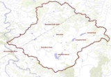
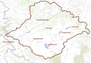
Ginninderra Creek
Ginninderra Creek is a water course that flows across the Ginninderra Plain through the Gungahlin and Belconnen regions in Canberra, Australia....
, which is now in part occupied by the Canberra districts of Belconnen
Belconnen
Belconnen is a district of Canberra, the capital city of Australia, comprising 25 suburbs with 29,900 dwellings housing 82,247 people of the 311,518 people in the Australian Capital Territory ....
and Gungahlin
Gungahlin
Gungahlin is a name of a district and the northernmost town centre of Canberra, Australia. Gungahlin is situated 10 km north of Canberra's city centre and is one of five satellites of Canberra including Woden, Tuggeranong, Weston Creek and Belconnen. Currently Gungahlin comprises 11 suburbs,...
.
The word 'Ginninderra' is one of several - Molonglo, Gold Creek and Monaro are others - that hold longstanding connections to Canberra's local history. The Ginninderra Cricket Club, Ginninderra District High School and Ginninderra Labor Club are examples. One of the local ACT electorates is called Ginninderra
Ginninderra electorate
The Ginninderra electorate is one of the three electorates for the unicameral 17-member Australian Capital Territory Legislative Assembly. It has five seats, and is the smallest of the electorates in geographic area.-History:...
. The name is celebrated through the place name Ginninderra Drive, an arterial road that traverses the Canberra district of Belconnen
Belconnen
Belconnen is a district of Canberra, the capital city of Australia, comprising 25 suburbs with 29,900 dwellings housing 82,247 people of the 311,518 people in the Australian Capital Territory ....
.
Ginninderra Plain
Ginninderra Creek
Ginninderra Creek is a water course that flows across the Ginninderra Plain through the Gungahlin and Belconnen regions in Canberra, Australia....
, which empties into the Murrumbidgee River
Murrumbidgee River
The Murrumbidgee River is a major river in the state of New South Wales, Australia, and the Australian Capital Territory . A major tributary of the Murray River, the Murrumbidgee flows in a west-northwesterly direction from the foot of Peppercorn Hill in the Fiery Range of the Snowy Mountains,...
and forms part of the Murray-Darling Basin
Murray-Darling Basin
The Murray-Darling basin is a large geographical area in the interior of southeastern Australia, whose name is derived from its two major rivers, the Murray River and the Darling River. It drains one-seventh of the Australian land mass, and is currently by far the most significant agricultural...
. The urban environs of the city of Canberra
Canberra
Canberra is the capital city of Australia. With a population of over 345,000, it is Australia's largest inland city and the eighth-largest city overall. The city is located at the northern end of the Australian Capital Territory , south-west of Sydney, and north-east of Melbourne...
straddle the Ginninderra Plain, Molonglo Plains
Molonglo Plains
The Molonglo Plain generally refers to the flood plain of the Molonglo River and specifically the one located in the Australian Capital Territory that was inundated during the mid 1960s in order to create Lake Burley Griffin...
, the Limestone Plain, and the Tuggeranong Plain
Tuggeranong
Tuggeranong is the southernmost town centre of Canberra, the capital city of Australia. It comprises 19 suburbs with a total of 31,819 dwellings, housing 87,119 people of the 324,034 people in the Australian Capital Territory . The district occupies 117 square kilometres to the east of the...
(Isabellas Plain).
History
Earliest written reference to the area use the spelling 'Ginninginderry' though by mid 19th century the 'Ginninderra' variation was in general use. The name Ginninderra is derived from the Aboriginal word for the creek which flows through the district of Ginin-ginin-derry which is said to mean sparkling or throwing out little rays of light.George Palmers established his Palmerville Estate in 1826 in Ginninginderry with a homestead located on the banks of Ginninderra Creek adjacent to the presentday suburb of Giralang
Giralang, Australian Capital Territory
Giralang is a suburb of Canberra, Australia in the district of Belconnen. The suburb is named after the word in the language of the Wiradhuri Aboriginal tribe of the Central West of New South Wales, meaning star. The suburb name was gazetted on 15 January 1974...
. The estate encompassed much of what is now Belconnen
Belconnen
Belconnen is a district of Canberra, the capital city of Australia, comprising 25 suburbs with 29,900 dwellings housing 82,247 people of the 311,518 people in the Australian Capital Territory ....
and southern Gungahlin
Gungahlin
Gungahlin is a name of a district and the northernmost town centre of Canberra, Australia. Gungahlin is situated 10 km north of Canberra's city centre and is one of five satellites of Canberra including Woden, Tuggeranong, Weston Creek and Belconnen. Currently Gungahlin comprises 11 suburbs,...
. It adjoined the Charnwood Estate to the west and Yarralumla Estate to the east. The combined area of the Ginninderra and Charnwood Estates was nearly 20,150 acres (8155 ha). Between the years 1830 and 1836, the colonial surveyor Robert Hoddle
Robert Hoddle
Robert Hoddle was a surveyor of Port Phillip in the 1830s, and the creator of the Hoddle Grid, the street grid system upon which inner city Melbourne is based. He was also an accomplished artist and depicted scenes of the Port Philip region as well as New South Wales...
made several visits to the district, to survey property boundaries. He captured Ginninderra's wild beauty in watercolour and ink. The property was sold to William Davis, also from a prominent local family, and it continued to prosper.
The second wave of Ginninderra settlement began in the early 1850s with free settlers such as the Rolfe, Shumack, Gillespie and Gribble families. These settlers established wheat and sheep properties such as 'Weetangara', 'Gold Creek'
Gold Creek Homestead
Gold Creek Homestead is a 140-year old stone and brick building located off Gungahlin Drive in Ngunnawal a north-western suburb of Canberra, the Australian Capital Territory, Australia....
,'The Valley' and 'Tea Gardens'. During the mid 19th century Ginninderra was predominantly a wheat growing district especially for the smaller landholders. Much of the local produce supplied the large workforce at the region's goldfields located at Braidwood
Braidwood
-Places:* Braidwood, New South Wales, Australia* Braidwood, South Lanarkshire, Scotland* Braidwood, Illinois, United States of America-People:* Thomas Braidwood , founder of a school for the deaf in Scotland...
and Major's Creek.
During the first half of the twentieth century Ginninderra developed a reputation for high quality merino wool. Henry ‘Babe’ Curran of Deasland near Ginninderra Village achieved a world record price at auction. That year’s record auction prices helped perpetuate the myth that the country’s woolgrowers were all millionaires. The centre of the local wool industry was the Ginninderra Woolshed, the district’s largest, (the site of which was located close to the presentday intersection of William Slim Drive and Baldwin Drive in the suburb of Giralang
Giralang, Australian Capital Territory
Giralang is a suburb of Canberra, Australia in the district of Belconnen. The suburb is named after the word in the language of the Wiradhuri Aboriginal tribe of the Central West of New South Wales, meaning star. The suburb name was gazetted on 15 January 1974...
. The structure was demolished in the early 1970s to make way for the urban development of Belconnen.
Key events in Gininnderra:
| Year | Event |
|---|---|
| 1859 | Ginninderra Post Office opens |
| 1869 | Telegraph service commences |
| 1872 | St Francis Church opens |
| 1905 | Bushfire destroys Ginninderra General Store |
| 1914 | Crickets Arms Hotel destroyed by fire |
| 1950 | Ginniderra residents connected to the electricity supply |
| 1962 | Ginninderra Post Office and Ginninderra Schoolhouse close |
| 1967 | Foundation stone laid for establishment of Belconnen district |
| 1990 | Ginninderra Village renamed Gold Creek Village |
| 1992 | Palmerston, first suburb in Gungahlin district established |
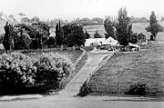
Ginninderra Village
This collection of buildings became known as Ginninderra Village.- The General Store survived until 1905 when it was destroyed by a bushfire.
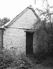
- Ginninderra Blacksmith. Today this wood and corrugated iron structure represents one of the best-preserved examples of its type in Australia.
- Farmers' Union. This building was transported to the Hall Showground where it now serves as a sports pavilion
- Ginninderra Schoolhouse
- Police Station
- Ginnninderra Post Office. With the closure of the Ginninderra Post Office in the 1962, local commerce within Ginninderra shifted completely to the village of HallHall, Australian Capital TerritoryHall is a small town in the north of the Australian Capital Territory , Australia. It was founded in 1882, named after the first landholder in the area, Henry Hall. In 1911 Hall was included within the boundary of the land allocated for the Australian Capital Territory, close to the north western...
.
- St Francis of Ginninderra Church. In 1872, the doors of St Francis of Ginninderra, a Roman Catholic Church opened to Sunday worship. This very modest bluestone building was located near the Ginninderra post office. St Francis also served for a time as a public school. The church closed when its congregation moved to St Francis Xavier Church located in Hall after it opened in April 1910.
- Old Tree Hill Sports Ground
- Cricketers Arm Hotel
Decline
In 1962, with the retirement of local schoolteacher and postmaster, Richard O’Sullivan, the last of the Ginninderra Village original buildings, the post office and the Ginninderra Public School permanently closed. Students moved to the nearby Hall public School. The few remaining buildings in the former village are a timber hall (the former St Francis Church) and the Ginninderra Schoolhouse which are both located today within the tourist precinct of the Gold Creek Village in the suburb of NichollsNicholls, Australian Capital Territory
Nicholls is a suburb in the Canberra, Australia district of Gungahlin is named after Sir Douglas Nicholls , a former Governor of South Australia. It was gazetted on 18 October 1991. Streets are named after sportsmen and sportswomen....
.
Further reading
- McDonald, J. Kay (1985) Exploring the ACT and Southeast New South Wales, Kangaroo Press, Sydney, ISBN 0-86417-049-1
Gillespie L, (1992), Ginninderra, Forerunner to Canberra: a history of the Ginninderra district, ACT Heritage Unit, ISBN 0959025510