
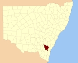
Murray County, New South Wales
Encyclopedia

Nineteen Counties
The Nineteen Counties were the limits of location in the colony of New South Wales defined by the Governor of New South Wales Sir Ralph Darling in 1826 in accordance with a government order from Lord Bathurst, the secretary of State. Counties had been used since the first year of settlement, with...
in New South Wales
New South Wales
New South Wales is a state of :Australia, located in the east of the country. It is bordered by Queensland, Victoria and South Australia to the north, south and west respectively. To the east, the state is bordered by the Tasman Sea, which forms part of the Pacific Ocean. New South Wales...
and is now one of the 141 Lands administrative divisions of New South Wales. It included the area which is now part of Canberra
Canberra
Canberra is the capital city of Australia. With a population of over 345,000, it is Australia's largest inland city and the eighth-largest city overall. The city is located at the northern end of the Australian Capital Territory , south-west of Sydney, and north-east of Melbourne...
and as far north as Lake George
Lake George (New South Wales)
Lake George is a lake in south-eastern New South Wales, Australia about 30 minutes drive north-east of Canberra along the Federal Highway en route to Sydney.-Geography / Geology:...
and Yass
Yass, New South Wales
Yass is a town in the Southern Tablelands of New South Wales, Australia in Yass Valley Shire. The name appears to have been derived from an Aboriginal word, "Yarrh" , said to mean 'running water'....
. It was originally bounded on the west by the Murrumbidgee River
Murrumbidgee River
The Murrumbidgee River is a major river in the state of New South Wales, Australia, and the Australian Capital Territory . A major tributary of the Murray River, the Murrumbidgee flows in a west-northwesterly direction from the foot of Peppercorn Hill in the Fiery Range of the Snowy Mountains,...
, on the east by the Shoalhaven River
Shoalhaven River
The Shoalhaven River is a river rising from the Southern Tablelands and flowing into the ocean near Nowra on the South Coast of New South Wales, Australia.- History :...
and on the north by the Yass River
Yass River
The Yass River is a river in the state of New South Wales, Australia. The town of Yass is located on the Yass River a short distance from its confluence with the Murrumbidgee River.There are two competing theories as to the origin of the name Yass...
. A large area of the county was transferred to the Commonwealth government in 1909 in the Seat of Government Acceptance Act
Seat of Government Acceptance Act 1909
The Seat of Government Acceptance Act 1909 is an Australian Commonwealth Government act, that in conjunction with the Seat of Government Surrender Act 1909 transferred land from the state of New South Wales to the Commonwealth for the creation of the Federal Capital Territory .The act was signed on...
to make part of the Australian Capital Territory
Australian Capital Territory
The Australian Capital Territory, often abbreviated ACT, is the capital territory of the Commonwealth of Australia and is the smallest self-governing internal territory...
, along with land in Cowley County
Cowley County, New South Wales
Cowley County is one of the 141 Cadastral divisions of New South Wales. It contains the locality of Cavan. It was originally bordered on the north, east and part of the south by the Murrumbidgee River, and on the west by the Goodradigbee River...
. Since then, the ACT border is now part of the western boundary. Part of the ACT border is determined by property boundaries in the Parish of Keewong, in the County of Murray; specifically the southern end of portions 177, 218, 211, 36, and 38. This is mentioned in the Seat of Government Acceptance Act of 1909
Murray County is named in honour of Lieutenant-Governor, Sir George Murray
George Murray (Lieutenant-Governor)
Sir George Murray, GCB, GCH, FRS was a Scottish soldier and politician.-Background and education:Murray was born in Perth, the second son of Sir William Murray, of Ochtertyre, 5th Baronet , and was educated at the Royal High School, Edinburgh and the University of Edinburgh.-Military career:In...
(1772-1846). The electoral district of United Counties of Murray and St Vincent was the first electoral district for the area, between 1856 and 1859.
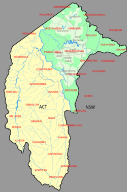
Parishes within this county
The four parishes of Canberra, Yarrolumla, Narrabundah and Gigerline became part of the Australian Capital TerritoryAustralian Capital Territory
The Australian Capital Territory, often abbreviated ACT, is the capital territory of the Commonwealth of Australia and is the smallest self-governing internal territory...
in 1911. Some of the other parishes are smaller than they were in the nineteenth century, due to land being taken out of them for the ACT; this includes Tuggeranong, Queanbeyan, Amungula, Pialligo, Goorooyarroo, Ginninderra and Weetangera.
Alterations to parishes on the ACT/NSW border, listed clockwise from the north-west:
- Nearly all of the Parish of Weetangera becomes part of the ACT except for the small section near Ginninderra falls at 35°12′22"S 148°57′35"E
- A small portion of the Parish of Wallaroo becomes part of the ACT at 35°11′54"S 149°00′00"E (located to the north-west of Ginninderra Creek)
- About half of the Parish of Ginninderra joins the ACT (including Hall)
- A minuscule portion of the Parish of Bedulluck joins the ACT, near the northern tip of the territory.
- Two non-continuous parts of the Parish of Goorooyarroo join the ACT, which make up about two fifths of the parish area in total. (Northern GungahlinGungahlinGungahlin is a name of a district and the northernmost town centre of Canberra, Australia. Gungahlin is situated 10 km north of Canberra's city centre and is one of five satellites of Canberra including Woden, Tuggeranong, Weston Creek and Belconnen. Currently Gungahlin comprises 11 suburbs,...
area) - Nearly all of the Parish of Pialligo becomes part of the ACT (includes the current airportCanberra International AirportCanberra International Airport , now trading as Canberra Airport, is the airport serving Australia's capital city, Canberra, and the city of Queanbeyan, NSW. Located at the eastern edge of North Canberra, it is the 8th busiest airport in Australia. The airport is the main hub for Brindabella Airlines...
and land to the east of Mount MajuraMount MajuraMount Majura, is a small mountain located in Canberra, Australia. Mount Majura lies close to the more prominent Mount Ainslie and at 888 metres is the highest point in Canberra...
), except for a small point at 35°13′22"S 149°12′29"E (located between the two parts of Goorooyarroo that became part of the territory. - Most of the Parish of Amungula joins the ACT, leaving two non-contiguous segments on either side of the "arm" of the territory in the north-east; the northern section around 35°15′50"S 149°17′29"E; the southern around 35°20′48"S 149°19′49"E
- About a quarter of the Parish of Majura becomes part of the ACT, this leaves a tiny area separate from the main part of the parish, at 35°21′03"S 149°22′00"E
- A small section of the Parish of Carwoola becomes part of the ACT, this is located between the Molonglo RiverMolonglo RiverThe Molonglo River rises on the western side of the Great Dividing Range of eastern Australia in the state of New South Wales. Its source is on the other side of the mountain range from where the Shoalhaven River rises, in Tallaganda state forest at ~1200 metres altitude...
and the Goulburn-Queanbeyan railway line at 35°19′42"S 149°17′45"E - About half of the Parish of Queanbeyan joins the ACT (modern FyshwickFyshwick, Australian Capital TerritoryFyshwick is an industrial suburb of Canberra, located east of the South Canberra district. On Census night 2006, Fyshwick had a population of 54 people....
HumeHume, Australian Capital TerritoryHume is a suburb of Canberra in the district of Tuggeranong. The suburb is named after the explorer Hamilton Hume and streets are named after Australian industrialists and businessmen. Hume is a light-industrial suburb and there is no significant housing development...
) - A small portion of the Parish of Keewong which is to the east of the Murrumbidgee RiverMurrumbidgee RiverThe Murrumbidgee River is a major river in the state of New South Wales, Australia, and the Australian Capital Territory . A major tributary of the Murray River, the Murrumbidgee flows in a west-northwesterly direction from the foot of Peppercorn Hill in the Fiery Range of the Snowy Mountains,...
at 35°34′40"S 149°07′28"E joins the ACT.
Parish list
A full list of parishes found within this county (including the four former parishes of Canberra, Yarrolumla, Narrabundah and Gigerline which are now wholly in the ACT ); their current LGA and mapping coordinates to the approximate centre of each location is as follows:| Parish | LGA | Coordinates |
|---|---|---|
| Amungula | Palerang Council Palerang Council The Palerang Council is a Local Government Area in the Southern Tablelands Region of New South Wales, Australia. It is on the Kings Highway and the Sydney-Canberra railway.... |
35°16′54"S 149°18′04"E |
| Ballallaba | Palerang Council Palerang Council The Palerang Council is a Local Government Area in the Southern Tablelands Region of New South Wales, Australia. It is on the Kings Highway and the Sydney-Canberra railway.... |
35°33′54"S 149°28′04"E |
| Barnet | Palerang Council Palerang Council The Palerang Council is a Local Government Area in the Southern Tablelands Region of New South Wales, Australia. It is on the Kings Highway and the Sydney-Canberra railway.... |
35°13′54"S 149°42′04"E |
| Bedulluck | Yass Valley Council | 35°03′54"S 149°05′04"E |
| Boambolo | Yass Valley Council | 34°59′54"S 148°54′04"E |
| Bullongong | Palerang Council Palerang Council The Palerang Council is a Local Government Area in the Southern Tablelands Region of New South Wales, Australia. It is on the Kings Highway and the Sydney-Canberra railway.... |
35°34′54"S 149°24′04"E |
| Burra | Palerang Council Palerang Council The Palerang Council is a Local Government Area in the Southern Tablelands Region of New South Wales, Australia. It is on the Kings Highway and the Sydney-Canberra railway.... |
35°31′54"S 149°13′04"E |
| Butmaroo | Palerang Council Palerang Council The Palerang Council is a Local Government Area in the Southern Tablelands Region of New South Wales, Australia. It is on the Kings Highway and the Sydney-Canberra railway.... |
35°22′54"S 149°30′04"E |
| Bywong | Palerang Council Palerang Council The Palerang Council is a Local Government Area in the Southern Tablelands Region of New South Wales, Australia. It is on the Kings Highway and the Sydney-Canberra railway.... |
35°09′54"S 149°20′04"E |
| Canberra(former) | Australian Capital Territory Australian Capital Territory The Australian Capital Territory, often abbreviated ACT, is the capital territory of the Commonwealth of Australia and is the smallest self-governing internal territory... |
35°14′20"S 149°5′49"E |
| Carwoola | City of Queanbeyan | 35°22′54"S 149°18′04"E |
| Currandooly | Palerang Council Palerang Council The Palerang Council is a Local Government Area in the Southern Tablelands Region of New South Wales, Australia. It is on the Kings Highway and the Sydney-Canberra railway.... |
35°14′54"S 149°30′04"E |
| Ellenden | Palerang Council Palerang Council The Palerang Council is a Local Government Area in the Southern Tablelands Region of New South Wales, Australia. It is on the Kings Highway and the Sydney-Canberra railway.... |
35°07′54"S 149°30′04"E |
| Fairy Meadow | Palerang Council Palerang Council The Palerang Council is a Local Government Area in the Southern Tablelands Region of New South Wales, Australia. It is on the Kings Highway and the Sydney-Canberra railway.... |
35°14′54"S 149°37′04"E |
| Gigerline(former) | Australian Capital Territory Australian Capital Territory The Australian Capital Territory, often abbreviated ACT, is the capital territory of the Commonwealth of Australia and is the smallest self-governing internal territory... |
35°29′00"S 149°06′00"E |
| Ginninderra | Yass Valley Council | 35°09′54"S 149°04′04"E |
| Googong | City of Queanbeyan | 35°25′54"S 149°14′04"E |
| Goorooyarroo | Palerang Council Palerang Council The Palerang Council is a Local Government Area in the Southern Tablelands Region of New South Wales, Australia. It is on the Kings Highway and the Sydney-Canberra railway.... |
35°10′54"S 149°14′04"E |
| Gundaroo Gundaroo, New South Wales Gundaroo is a small village in the Southern Tablelands of New South Wales, Australia and in Yass Valley Council. It is situated to the east of the Yass River, about north of Sutton, about west of the Lake George range. At the 2006 census, Gundaroo had a population of 331.The explorers Charles... |
Yass Valley Council | 35°01′54"S 149°20′04"E |
| Hume | Yass Valley Council | 34°53′54"S 148°55′04"E |
| Jeir | Yass Valley Council | 35°02′54"S 148°59′04"E |
| Jinero | Palerang Council Palerang Council The Palerang Council is a Local Government Area in the Southern Tablelands Region of New South Wales, Australia. It is on the Kings Highway and the Sydney-Canberra railway.... |
35°31′54"S 149°36′04"E |
| Jinglemoney | Palerang Council Palerang Council The Palerang Council is a Local Government Area in the Southern Tablelands Region of New South Wales, Australia. It is on the Kings Highway and the Sydney-Canberra railway.... |
35°25′54"S 149°39′04"E |
| Jinjera | Palerang Council Palerang Council The Palerang Council is a Local Government Area in the Southern Tablelands Region of New South Wales, Australia. It is on the Kings Highway and the Sydney-Canberra railway.... |
35°41′54"S 149°29′04"E |
| Keewong | Palerang Council Palerang Council The Palerang Council is a Local Government Area in the Southern Tablelands Region of New South Wales, Australia. It is on the Kings Highway and the Sydney-Canberra railway.... |
35°35′54"S 149°12′04"E |
| Krawarree | Palerang Council Palerang Council The Palerang Council is a Local Government Area in the Southern Tablelands Region of New South Wales, Australia. It is on the Kings Highway and the Sydney-Canberra railway.... |
35°41′54"S 149°37′04"E |
| Lake George | Palerang Council Palerang Council The Palerang Council is a Local Government Area in the Southern Tablelands Region of New South Wales, Australia. It is on the Kings Highway and the Sydney-Canberra railway.... |
35°05′54"S 149°25′04"E |
| Larbert | Palerang Council Palerang Council The Palerang Council is a Local Government Area in the Southern Tablelands Region of New South Wales, Australia. It is on the Kings Highway and the Sydney-Canberra railway.... |
35°14′54"S 149°47′04"E |
| Majura | Palerang Council Palerang Council The Palerang Council is a Local Government Area in the Southern Tablelands Region of New South Wales, Australia. It is on the Kings Highway and the Sydney-Canberra railway.... |
35°18′54"S 149°25′04"E |
| Merigan | Goulburn Mulwaree Council Goulburn Mulwaree Council Goulburn Mulwaree Council is a Local Government Area of New South Wales, Australia. The council was formed as the Greater Argyle Council in 2004 as an amalgamation of Goulburn City and parts of the former Mulwaree Shire. It was renamed in 2005 following objections from the community... |
35°07′54"S 149°37′04"E |
| Molonglo | Palerang Council Palerang Council The Palerang Council is a Local Government Area in the Southern Tablelands Region of New South Wales, Australia. It is on the Kings Highway and the Sydney-Canberra railway.... |
35°24′54"S 149°29′04"E |
| Monkellan | Cooma-Monaro Shire | 35°39′54"S 149°12′04"E |
| Mulloon | Palerang Council Palerang Council The Palerang Council is a Local Government Area in the Southern Tablelands Region of New South Wales, Australia. It is on the Kings Highway and the Sydney-Canberra railway.... |
35°19′54"S 149°36′04"E |
| Murrumbateman | Yass Valley Council | 34°53′54"S 149°01′04"E |
| Nanima | Yass Valley Council | 34°57′54"S 149°02′04"E |
| Narrabundah(former) | Australian Capital Territory Australian Capital Territory The Australian Capital Territory, often abbreviated ACT, is the capital territory of the Commonwealth of Australia and is the smallest self-governing internal territory... |
35°19′51"S 149°05′46"E |
| Ollalulla | Palerang Council Palerang Council The Palerang Council is a Local Government Area in the Southern Tablelands Region of New South Wales, Australia. It is on the Kings Highway and the Sydney-Canberra railway.... |
35°38′54"S 149°33′04"E |
| Oronmear | Palerang Council Palerang Council The Palerang Council is a Local Government Area in the Southern Tablelands Region of New South Wales, Australia. It is on the Kings Highway and the Sydney-Canberra railway.... |
35°46′54"S 149°33′04"E |
| Palerang Council | Palerang Council Palerang Council The Palerang Council is a Local Government Area in the Southern Tablelands Region of New South Wales, Australia. It is on the Kings Highway and the Sydney-Canberra railway.... |
35°25′54"S 149°34′04"E |
| Pialligo | Palerang Council Palerang Council The Palerang Council is a Local Government Area in the Southern Tablelands Region of New South Wales, Australia. It is on the Kings Highway and the Sydney-Canberra railway.... |
35°13′22"S 149°12′29"E |
| Purrorumba | Yass Valley Council | 35°04′54"S 149°20′04"E |
| Queanbeyan | Palerang Council Palerang Council The Palerang Council is a Local Government Area in the Southern Tablelands Region of New South Wales, Australia. It is on the Kings Highway and the Sydney-Canberra railway.... |
35°20′54"S 149°15′04"E |
| Talagandra | Yass Valley Council | 35°04′54"S 149°12′04"E |
| Tantangera | Cooma-Monaro Shire | 35°38′54"S 149°17′04"E |
| Thurralilly | Palerang Council Palerang Council The Palerang Council is a Local Government Area in the Southern Tablelands Region of New South Wales, Australia. It is on the Kings Highway and the Sydney-Canberra railway.... |
35°28′54"S 149°31′04"E |
| Toual | Yass Valley Council | 34°59′54"S 149°11′04"E |
| Tuggeranong | City of Queanbeyan | 35°25′54"S 149°10′04"E |
| Urialla | Palerang Council Palerang Council The Palerang Council is a Local Government Area in the Southern Tablelands Region of New South Wales, Australia. It is on the Kings Highway and the Sydney-Canberra railway.... |
35°33′54"S 149°18′04"E |
| Wallaroo | Yass Valley Council | 35°08′54"S 148°58′04"E |
| Wamboin | Palerang Council Palerang Council The Palerang Council is a Local Government Area in the Southern Tablelands Region of New South Wales, Australia. It is on the Kings Highway and the Sydney-Canberra railway.... |
35°14′59"S 149°22′04"E |
| Warri | Palerang Council Palerang Council The Palerang Council is a Local Government Area in the Southern Tablelands Region of New South Wales, Australia. It is on the Kings Highway and the Sydney-Canberra railway.... |
35°21′54"S 149°40′04"E |
| Warroo | Yass Valley Council | 34°52′54"S 148°49′04"E |
| Weetangera | Yass Valley Council | 35°12′54"S 148°59′04"E |
| Werriwa | Palerang Council Palerang Council The Palerang Council is a Local Government Area in the Southern Tablelands Region of New South Wales, Australia. It is on the Kings Highway and the Sydney-Canberra railway.... |
35°04′54"S 149°31′04"E |
| Yanununbeyan | Palerang Council Palerang Council The Palerang Council is a Local Government Area in the Southern Tablelands Region of New South Wales, Australia. It is on the Kings Highway and the Sydney-Canberra railway.... |
35°29′54"S 149°24′04"E |
| Yarrolumla(former) | Australian Capital Territory Australian Capital Territory The Australian Capital Territory, often abbreviated ACT, is the capital territory of the Commonwealth of Australia and is the smallest self-governing internal territory... |
35°19′00"S 148°59′13"E |
| Yarrow | Palerang Council Palerang Council The Palerang Council is a Local Government Area in the Southern Tablelands Region of New South Wales, Australia. It is on the Kings Highway and the Sydney-Canberra railway.... |
35°27′54"S 149°19′04"E |
| Yass Yass, New South Wales Yass is a town in the Southern Tablelands of New South Wales, Australia in Yass Valley Shire. The name appears to have been derived from an Aboriginal word, "Yarrh" , said to mean 'running water'.... |
Yass Valley Council | 34°50′14"S 148°53′44"E |
External links
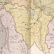
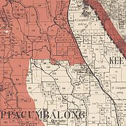
- A map of the County of Murray, Baker's Australian county atlas. 1843-1846
- Map of Murray county. W. & F. Ford, 1848