

Murrumbidgee River
Encyclopedia
The Murrumbidgee River is a major river in the state of New South Wales
, Australia, and the Australian Capital Territory
(ACT). A major tributary
of the Murray River
, the Murrumbidgee flows 900 kilometres (559 mi) in a west-northwesterly direction from the foot of Peppercorn Hill in the Fiery Range of the Snowy Mountains
, through the ACT, and to a confluence with the Murray.
The word Murrumbidgee means "big water" in the Wiradjuri language
, the local Aboriginal
language.
(ACT) are now affected by the complete elimination of large spring snow melt flows and a reduction of average annual flows of almost 50%, due to Tantangara Dam. Tantangara Dam was completed in 1960 on the headwaters of Murrumbidgee River and diverts approximately 99% of the river's flow at that point into Lake Eucumbene
. This had extremely serious effects on native fish populations and other native aquatic life and has led to serious habitat loss. It is said that the Murrumbidgee River through the ACT is only half the river it used to be.
The mainstream of the river system flows for 900 km (559 mi). The river's headwaters arise from the wet heath and bog at the foot of Peppercorn Hill situated along Long Plain which is within the Fiery Range of the Snowy Mountains
; and about 50 kilometres north of Kiandra
. From its headwaters it flows to its confluence with the Murray River
. The river flows for 66 km (41 mi) through the Australian Capital Territory
near Canberra
, picking up the important tributaries of the Molonglo
and Cotter River
s. The Murrumbidgee drains much of southern New South Wales and all of the Australian Capital Territory
, and is an important source of irrigation water for the Riverina
farming area.
The river system's current channels are relatively new with the Upper Murrumbidgee being an anabranch
of the Tumut River
(that once continued north along Mutta Mutta Creek) when geological uplift near Adaminaby
diverted its flow. The contemporary Murrumbidgee starts at Gundagai
but generally the stream that now includes the Upper Murrumbidgee is described as being part of the full river.
In June 2008 the Murray-Darling Basin Commission
released a report on the condition of the Murray-Darling basin
, with the Goulburn
and Murrumbidgee Rivers rated in a very poor condition in the Murray-Darling basin with fish stocks in both rivers were also rated as extremely poor, with 13 of the 22 native fish species found in the Murrumbidgee River.
informed the Governor of New South Wales that he anticipated finding "a considerable river of salt water (except at very wet seasons), called by the natives Mur-rum-big-gee". In the expedition journal, Throsby wrote as a marginal note: "This river or stream is called by the natives Yeal-am-bid-gie ...". The river he had stumbled upon was in fact the Molonglo River
, Throsby reached the actual river in April 1821.
In 1823, Brigade-Major John Ovens and Captain Mark Currie
reached the upper Murrumbidgee when exploring south of Lake George
. In 1829, Charles Sturt
and his party rowed and sailed down the length of the river from Narrandera to the Murray, and then down the Murray to the sea. They also rowed, sailing when possible, back up against the current. The Murrumbidgee basin was opened to settlement in the 1830s and soon became an important farming area.
 Ernest Favenc
, when writing on Australian exploration, commented on the relatively tardy European discovery of the river and that the river retained a name used by Indigenous Australians
:
from 1907 has significantly reduced flooding but, despite the dam, there were major floods in 1925 and 1974.
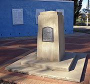
The most notable flood was in 1852 when the town of Gundagai
was swept away and 89 people, a third of the town's population, were killed. The town was rebuilt on higher ground.
In 1925, four people died and the flooding lasted for eight days.
The reduction in floods has consequences for wildlife, birds and trees. There has been a decline in bird populations and black box
flood plain eucalypt forest trees are starting to lose their crowns.

New South Wales
New South Wales is a state of :Australia, located in the east of the country. It is bordered by Queensland, Victoria and South Australia to the north, south and west respectively. To the east, the state is bordered by the Tasman Sea, which forms part of the Pacific Ocean. New South Wales...
, Australia, and the Australian Capital Territory
Australian Capital Territory
The Australian Capital Territory, often abbreviated ACT, is the capital territory of the Commonwealth of Australia and is the smallest self-governing internal territory...
(ACT). A major tributary
Tributary
A tributary or affluent is a stream or river that flows into a main stem river or a lake. A tributary does not flow directly into a sea or ocean...
of the Murray River
Murray River
The Murray River is Australia's longest river. At in length, the Murray rises in the Australian Alps, draining the western side of Australia's highest mountains and, for most of its length, meanders across Australia's inland plains, forming the border between New South Wales and Victoria as it...
, the Murrumbidgee flows 900 kilometres (559 mi) in a west-northwesterly direction from the foot of Peppercorn Hill in the Fiery Range of the Snowy Mountains
Snowy Mountains
The Snowy Mountains, known informally as "The Snowies", are the highest Australian mountain range and contain the Australian mainland's highest mountain, Mount Kosciuszko, which reaches 2,228 metres AHD, approximately 7310 feet....
, through the ACT, and to a confluence with the Murray.
The word Murrumbidgee means "big water" in the Wiradjuri language
Wiradjuri language
Wiradjuri is a Pama–Nyungan language of the Wiradhuric subgroup. It was the traditional language of the Wiradjuri people of Australia, but is no longer in general use. The process of reclaiming the language was greatly assisted by the publication in 2005 of A First Wiradjuri Dictionary by elder...
, the local Aboriginal
Indigenous Australians
Indigenous Australians are the original inhabitants of the Australian continent and nearby islands. The Aboriginal Indigenous Australians migrated from the Indian continent around 75,000 to 100,000 years ago....
language.
Flow
The reaches of the Murrumbidgee in the Australian Capital TerritoryAustralian Capital Territory
The Australian Capital Territory, often abbreviated ACT, is the capital territory of the Commonwealth of Australia and is the smallest self-governing internal territory...
(ACT) are now affected by the complete elimination of large spring snow melt flows and a reduction of average annual flows of almost 50%, due to Tantangara Dam. Tantangara Dam was completed in 1960 on the headwaters of Murrumbidgee River and diverts approximately 99% of the river's flow at that point into Lake Eucumbene
Lake Eucumbene
Lake Eucumbene is a man-made lake on the Eucumbene River in the Snowy Mountains of Southern New South Wales in Australia. The lake was created by the damming of the river as part of the Snowy Mountains Scheme. The dam was built between 1956 and 1958....
. This had extremely serious effects on native fish populations and other native aquatic life and has led to serious habitat loss. It is said that the Murrumbidgee River through the ACT is only half the river it used to be.
The mainstream of the river system flows for 900 km (559 mi). The river's headwaters arise from the wet heath and bog at the foot of Peppercorn Hill situated along Long Plain which is within the Fiery Range of the Snowy Mountains
Snowy Mountains
The Snowy Mountains, known informally as "The Snowies", are the highest Australian mountain range and contain the Australian mainland's highest mountain, Mount Kosciuszko, which reaches 2,228 metres AHD, approximately 7310 feet....
; and about 50 kilometres north of Kiandra
Kiandra, New South Wales
Kiandra is an abandoned gold mining town and the birthplace of Australian skiing. The town is situated in the Snowy Mountains of New South Wales, Australia, in the Snowy River Shire inside the Kosciuszko National Park. Its name is a corruption of Aboriginal 'Gianderra' for 'sharp stones for...
. From its headwaters it flows to its confluence with the Murray River
Murray River
The Murray River is Australia's longest river. At in length, the Murray rises in the Australian Alps, draining the western side of Australia's highest mountains and, for most of its length, meanders across Australia's inland plains, forming the border between New South Wales and Victoria as it...
. The river flows for 66 km (41 mi) through the Australian Capital Territory
Australian Capital Territory
The Australian Capital Territory, often abbreviated ACT, is the capital territory of the Commonwealth of Australia and is the smallest self-governing internal territory...
near Canberra
Canberra
Canberra is the capital city of Australia. With a population of over 345,000, it is Australia's largest inland city and the eighth-largest city overall. The city is located at the northern end of the Australian Capital Territory , south-west of Sydney, and north-east of Melbourne...
, picking up the important tributaries of the Molonglo
Molonglo River
The Molonglo River rises on the western side of the Great Dividing Range of eastern Australia in the state of New South Wales. Its source is on the other side of the mountain range from where the Shoalhaven River rises, in Tallaganda state forest at ~1200 metres altitude...
and Cotter River
Cotter River
The Cotter River is a fresh water river in the Australian Capital Territory. It is a tributary of the Murrumbidgee River and part of Murray-Darling Basin. The Cotter River is one of two rivers—the Queanbeyan River is the other—that meet the water supply needs of the Canberra and...
s. The Murrumbidgee drains much of southern New South Wales and all of the Australian Capital Territory
Australian Capital Territory
The Australian Capital Territory, often abbreviated ACT, is the capital territory of the Commonwealth of Australia and is the smallest self-governing internal territory...
, and is an important source of irrigation water for the Riverina
Riverina
The Riverina is an agricultural region of south-western New South Wales , Australia. The Riverina is distinguished from other Australian regions by the combination of flat plains, warm to hot climate and an ample supply of water for irrigation. This combination has allowed the Riverina to develop...
farming area.
The river system's current channels are relatively new with the Upper Murrumbidgee being an anabranch
Anabranch
An anabranch is a section of a river or stream that diverts from the main channel or stem of the watercourse and rejoins the main stem downstream. Local anabranches can be the result of small islands in the watercourse...
of the Tumut River
Tumut River
The Tumut River is a river in New South Wales, Australia.The Tumut River rises on the northern face of Mount Jagungal in the Snowy Mountains of southern New South Wales. It flows about 145km before joining the Murrumbidgee River, at Darbalara near the town of Gundagai...
(that once continued north along Mutta Mutta Creek) when geological uplift near Adaminaby
Adaminaby, New South Wales
Adaminaby is a small town near the Snowy Mountains located north-west of Cooma, New South Wales, Australia, in the Snowy River Shire.The historic town, of about 234 people, is a trout fishing centre and winter sports destination situated at above sea level. It is one of the highest towns in...
diverted its flow. The contemporary Murrumbidgee starts at Gundagai
Gundagai, New South Wales
Gundagai is a town in New South Wales, Australia. Although a small town, Gundagai is a popular topic for writers and has become a representative icon of a typical Australian country town...
but generally the stream that now includes the Upper Murrumbidgee is described as being part of the full river.
In June 2008 the Murray-Darling Basin Commission
Murray-Darling Basin Commission
The Murray-Darling Basin Authority is the principal government agency in charge of managing the Murray-Darling Basin in an integrated and sustainable manner. The Authority is the statutory agency that manages, in conjunction with the Basin states, the Murray–Darling Basin’s water resources in the...
released a report on the condition of the Murray-Darling basin
Murray-Darling Basin
The Murray-Darling basin is a large geographical area in the interior of southeastern Australia, whose name is derived from its two major rivers, the Murray River and the Darling River. It drains one-seventh of the Australian land mass, and is currently by far the most significant agricultural...
, with the Goulburn
Goulburn River (Victoria)
The Goulburn River is a major inland river in Victoria, Australia.The headwaters of the Goulburn River rise in the western end of the Victoria Alps, near Mount Buller. The Eildon Dam creates Lake Eildon, a major storage of water for irrigation...
and Murrumbidgee Rivers rated in a very poor condition in the Murray-Darling basin with fish stocks in both rivers were also rated as extremely poor, with 13 of the 22 native fish species found in the Murrumbidgee River.
Exploration
The Murrumbidgee River was known to Europeans before it was actually discovered by them. In 1820 the explorer Charles ThrosbyCharles Throsby
Charles Throsby was an Australian explorer, pioneer and parliamentarian. He opened up much new land beyond the Blue Mountains for colonial settlement. He was a grazier, and became a prominent member of New South Wales society.- Early life :...
informed the Governor of New South Wales that he anticipated finding "a considerable river of salt water (except at very wet seasons), called by the natives Mur-rum-big-gee". In the expedition journal, Throsby wrote as a marginal note: "This river or stream is called by the natives Yeal-am-bid-gie ...". The river he had stumbled upon was in fact the Molonglo River
Molonglo River
The Molonglo River rises on the western side of the Great Dividing Range of eastern Australia in the state of New South Wales. Its source is on the other side of the mountain range from where the Shoalhaven River rises, in Tallaganda state forest at ~1200 metres altitude...
, Throsby reached the actual river in April 1821.
In 1823, Brigade-Major John Ovens and Captain Mark Currie
Mark John Currie
Captain Mark John Currie RN played a significant role in the exploration of Australia and the foundation of the Swan River Colony, later named 'Western Australia'....
reached the upper Murrumbidgee when exploring south of Lake George
Lake George (New South Wales)
Lake George is a lake in south-eastern New South Wales, Australia about 30 minutes drive north-east of Canberra along the Federal Highway en route to Sydney.-Geography / Geology:...
. In 1829, Charles Sturt
Charles Sturt
Captain Charles Napier Sturt was an English explorer of Australia, and part of the European Exploration of Australia. He led several expeditions into the interior of the continent, starting from both Sydney and later from Adelaide. His expeditions traced several of the westward-flowing rivers,...
and his party rowed and sailed down the length of the river from Narrandera to the Murray, and then down the Murray to the sea. They also rowed, sailing when possible, back up against the current. The Murrumbidgee basin was opened to settlement in the 1830s and soon became an important farming area.
Ernest Favenc
Ernest Favenc was an explorer of Australia, a journalist and historian.-Personal life:Favenc was born in Walworth, Surrey, England. Of Huguenot descent, he was the son of Abraham George Favenc, merchant, and his wife Emma, née Jones...
, when writing on Australian exploration, commented on the relatively tardy European discovery of the river and that the river retained a name used by Indigenous Australians
Indigenous Australians
Indigenous Australians are the original inhabitants of the Australian continent and nearby islands. The Aboriginal Indigenous Australians migrated from the Indian continent around 75,000 to 100,000 years ago....
:
Here we may remark on the tenacity with which the Murrumbidgee River long eluded the eye of the white man. It is scarcely probable that Meehan and Hume, who on this occasion were within comparatively easy reach of the head waters, could have seen a new inland river at that time without mentioning the fact, but there is no record traceable anywhere as to the date of its discovery, or the name of its finder. When in 1823 Captain Currie and Major Ovens were led along its bank on to the beautiful Maneroo country by Joseph Wild, the stream was then familiar to the early settlers and called the Morumbidgee. Even in 1821, when Hume found the Yass Plains, almost on its bank, he makes no special mention of the river. From all this we may deduce the extremely probable fact that the position of the river was shown to some stockrider by a native, who also confided the aboriginal name, and so it gradually worked the knowledge of its identity into general belief. This theory is the more feasible as the river has retained its native name. If a white man of any known position had made the discovery, it would at once have received the name of some person holding official sway.
Floods
The river has risen above 7 metres (23 ft) at Gundagai nine times between 1852 and 2010, an average of just under once every eleven years. Since 1925, flooding has been minor with the exception of floods in 1974 and in December 2010, when the river rose to 10.2 metres (33 ft) at Gundagai. In the 1852 disaster, the river rose to just over 12.2 m (40 ft). The following year the river again rose to just over 12.5 m (41 ft). The construction of Burrinjuck DamBurrinjuck Dam
Burrinjuck Dam is a high, concrete gravity dam on the Murrumbidgee River approximately 60 km from Yass, New South Wales, Australia. The Yass and Goodradigbee Rivers flow into the dam. The dam divides the upper and lower catchment of the Murrumbidgee and is the headwater storage for the...
from 1907 has significantly reduced flooding but, despite the dam, there were major floods in 1925 and 1974.
The most notable flood was in 1852 when the town of Gundagai
Gundagai, New South Wales
Gundagai is a town in New South Wales, Australia. Although a small town, Gundagai is a popular topic for writers and has become a representative icon of a typical Australian country town...
was swept away and 89 people, a third of the town's population, were killed. The town was rebuilt on higher ground.
In 1925, four people died and the flooding lasted for eight days.
The reduction in floods has consequences for wildlife, birds and trees. There has been a decline in bird populations and black box
Eucalyptus largiflorens
Eucalyptus largiflorens, or Black Box, is a species of Eucalyptus which is endemic to Australia. It is a tree grows up to 20 metres in height...
flood plain eucalypt forest trees are starting to lose their crowns.
Wetlands
Major wetlands along the Murrumbidgee or associated with the Murrumbidgee catchment include:- Lowbidgee FloodplainLowbidgee FloodplainThe Lowbidgee Floodplain extends from Balranald to near Waradgery Station, about 20 km west of Hay, in south-western New South Wales. It comprises an extensive floodplain of the lower Murrumbidgee River and its tributaries, including the confluence of the Murrumbidgee with the Lachlan River,...
, 2000 square kilometres (772 sq mi) between Maude and Balranald - Mid-Murrumbidgee Wetlands along the river from Narrandera to Carathool
- Fivebough and Tuckerbil SwampsFivebough and Tuckerbil SwampsFivebough and Tuckerbil Swamps are two swamps lying close to the Riverina town of Leeton in New South Wales, Australia. They lie on Crown Land within the Murrumbidgee Irrigation Area...
- Tomneys Plain
- Micalong Swamp
- Lake GeorgeLake George (New South Wales)Lake George is a lake in south-eastern New South Wales, Australia about 30 minutes drive north-east of Canberra along the Federal Highway en route to Sydney.-Geography / Geology:...
- Yaouk Swamp
- Black Swamp & Coopers Swamp
- Big Badja Swamp
Major tributaries
- Gudgenby RiverGudgenby RiverThe Gudgenby River is a river in the Australian Capital Territory that flows predominantly through the forests of the Namadgi National Park. The river catchment contains ecologically significant alpine wetlands...
- Naas RiverNaas RiverThe Naas River rises in the southern ranges of the Australian Capital Territory within Namadgi National Park. Its watershed boundary defines the southern border of the A.C.T. with New South Wales. It flows into the Gudgenby River near Tharwa village, to the south of Canberra....
(Naas flows into Gudgenby before Murrumbidgee despite what appears on the 1:100000 topographic map)
- Naas River
- Molonglo RiverMolonglo RiverThe Molonglo River rises on the western side of the Great Dividing Range of eastern Australia in the state of New South Wales. Its source is on the other side of the mountain range from where the Shoalhaven River rises, in Tallaganda state forest at ~1200 metres altitude...
- Queanbeyan RiverQueanbeyan RiverThe Queanbeyan River is a tributary of the Molonglo River and part of Murray-Darling Basin. The river is 70 kilometres in length and the river catchment is 96,000 hectares in size...
- Queanbeyan River
- Cotter RiverCotter RiverThe Cotter River is a fresh water river in the Australian Capital Territory. It is a tributary of the Murrumbidgee River and part of Murray-Darling Basin. The Cotter River is one of two rivers—the Queanbeyan River is the other—that meet the water supply needs of the Canberra and...
- Tumut RiverTumut RiverThe Tumut River is a river in New South Wales, Australia.The Tumut River rises on the northern face of Mount Jagungal in the Snowy Mountains of southern New South Wales. It flows about 145km before joining the Murrumbidgee River, at Darbalara near the town of Gundagai...
- Yass RiverYass RiverThe Yass River is a river in the state of New South Wales, Australia. The town of Yass is located on the Yass River a short distance from its confluence with the Murrumbidgee River.There are two competing theories as to the origin of the name Yass...
- Lachlan RiverLachlan River- Course :The river rises in the central highland of New South Wales, part of the Great Dividing Range, 13 km east of Gunning. Its major headwaters, the Carcoar River, the Belubula River and the Abercrombie River converge near the town of Cowra. Minor tributaries include the Morongla Creek...
- Abercrombie RiverAbercrombie RiverThe Abercrombie River is a river in New South Wales, Australia, flowing from Mount Werong westward to the Wyangala Dam near Cowra. The river is a tributary of the Lachlan, which it joins at Wyangala lake....
- Abercrombie River
Population centres
- TharwaTharwa, Australian Capital TerritoryTharwa is a small village within the Australian Capital Territory, south of Canberra, the capital city of Australia. At the 2006 census, Tharwa had a population of 109....
- CanberraCanberraCanberra is the capital city of Australia. With a population of over 345,000, it is Australia's largest inland city and the eighth-largest city overall. The city is located at the northern end of the Australian Capital Territory , south-west of Sydney, and north-east of Melbourne...
particularly TuggeranongTuggeranongTuggeranong is the southernmost town centre of Canberra, the capital city of Australia. It comprises 19 suburbs with a total of 31,819 dwellings, housing 87,119 people of the 324,034 people in the Australian Capital Territory . The district occupies 117 square kilometres to the east of the... - JugiongJugiong, New South WalesJugiong is a village community on the banks of the Murrumbidgee River, in the central east part of the Riverina. It is situated just off the Hume Highway, by road, about 30 kilometres southwest from Bookham and 40 kilometres northeast from Gundagai...
- GundagaiGundagai, New South WalesGundagai is a town in New South Wales, Australia. Although a small town, Gundagai is a popular topic for writers and has become a representative icon of a typical Australian country town...
- WantabadgeryWantabadgery, New South WalesWantabadgery is a village community in the central eastern part of the Riverina and situated about 35 kilometres east from Wagga Wagga and 19 kilometres west from Nangus...
- Wagga WaggaWagga Wagga, New South WalesWagga Wagga is a city in New South Wales, Australia. Straddling the Murrumbidgee River, and with an urban population of 46,735 people, Wagga Wagga is the state's largest inland city, as well as an important agricultural, military, and transport hub of Australia...
- NarranderaNarrandera, New South Wales-Transport:Narrandera is well served for transport. The Sturt Highway and the Newell Highways cross, just south of Narrandera. Greyhound buses pass daily - note that the destination can be listed as Jillenbah....
- YancoYanco, New South WalesYanco is a village with a population of 572 in Leeton Shire in South Western New South Wales, Australia. Yanco is a Wiradjuri aboriginal language word meaning the sound of running water. Yanco is located three kilometres from Leeton along the Irrigation Way...
- LeetonLeeton, New South WalesLeeton is a town in the Riverina region of New South Wales, Australia. Leeton is situated approximately 550 km west of Sydney and 450 km north of Melbourne in the productive Murrumbidgee Irrigation Area. Leeton is administered by Leeton Shire Council...
- Darlington PointDarlington Point, New South WalesDarlington Point is a small town on the banks of the Murrumbidgee River in the Riverina district of western New South Wales, Australia. It is part of the Murrumbidgee Shire local government area. The township centre is four kilometres from the Sturt Highway, along Kidman Way. ...
- HayHay, New South WalesHay is a town in the western Riverina region of south western New South Wales , Australia. It is the administrative centre of Hay Shire Local Government Area and the centre of a prosperous and productive agricultural district on the wide Hay Plains....
- BalranaldBalranald, New South WalesBalranald is a town and local government area in the Riverina district of New South Wales, Australia. At the 2006 census the population was 1,216....
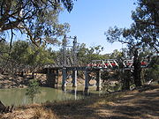
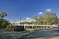
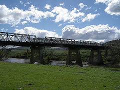
River crossings
The list below notes past and present bridges that cross over the Murrumbidgee River. There were numerous other crossings before the bridges were constructed and many of these still exist today.Downstream from Wagga Wagga
| Crossing | Image | Coordinates | Built | Location | Description | Notes |
|---|---|---|---|---|---|---|
| Balranald Bridge | 1973 | Balranald Balranald, New South Wales Balranald is a town and local government area in the Riverina district of New South Wales, Australia. At the 2006 census the population was 1,216.... |
Sturt Highway Sturt Highway The Sturt Highway is an Australian highway in New South Wales, Victoria, and South Australia. It is part of the Auslink National network and is part of the main highway route between Sydney and Adelaide.-Route:... |
|||
| Matthews Bridge | Maude Maude, New South Wales Maude is a village on the north bank of the Murrumbidgee River in New South Wales, Australia. It is in between Hay and Balranald in Hay Shire. It is located 55 kilometres downstream from Hay and 25 kilometres upstream from the junction of the Lachlan River with the Murrumbidgee. At the 2006... |
|||||
| Hay Bridge | 1973 | Hay Hay, New South Wales Hay is a town in the western Riverina region of south western New South Wales , Australia. It is the administrative centre of Hay Shire Local Government Area and the centre of a prosperous and productive agricultural district on the wide Hay Plains.... |
Cobb Highway Cobb Highway The Cobb Highway is a State highway in western New South Wales, Australia. From north to south the Cobb Highway begins at its junction with the Barrier Highway near Wilcannia and runs south through the townships of Ivanhoe, Booligal, Hay and Deniliquin. It ends at Moama where the... |
|||
| Carrathool Bridge | 1924 | Carrathool Carrathool, New South Wales Carrathool is a village in the western Riverina region of New South Wales, Australia, located in the Carrathool Shire. In 2006, Carrathool had a population of 325 people. It is about north of the Sturt Highway between Darlington Point and Hay... |
||||
| Darlington Point Bridge | Darlington Point Darlington Point, New South Wales Darlington Point is a small town on the banks of the Murrumbidgee River in the Riverina district of western New South Wales, Australia. It is part of the Murrumbidgee Shire local government area. The township centre is four kilometres from the Sturt Highway, along Kidman Way. ... |
Kidman Way Kidman Way The Kidman Way is an important highway in New South Wales , Australia, which is designated as State Highway 87. It is named after Sir Sidney Kidman, Australian cattle king and philanthropist who owned a large number of cattle stations along the path, many still owned by his descendants. It is an... |
||||
| Euroley Bridge | 2003 | Yanco Yanco, New South Wales Yanco is a village with a population of 572 in Leeton Shire in South Western New South Wales, Australia. Yanco is a Wiradjuri aboriginal language word meaning the sound of running water. Yanco is located three kilometres from Leeton along the Irrigation Way... |
||||
| Narrandera Rail Bridge | Narrandera Narrandera, New South Wales -Transport:Narrandera is well served for transport. The Sturt Highway and the Newell Highways cross, just south of Narrandera. Greyhound buses pass daily - note that the destination can be listed as Jillenbah.... |
Tocumwal railway line Tocumwal railway line, New South Wales The Tocumwal railway line is a closed railway line in New South Wales, Australia. The line branched from the still open Junee - Hay line at Narrandera station and then headed south west to Tocumwal station where there was a break-of-gauge with the Victorian Railways Goulburn Valley line from... |
||||
| Narrandera Bridge | Newell Highway Newell Highway The Newell Highway is the longest highway in New South Wales, Australia. It runs parallel to the eastern coast about 400 kilometres inland, and is the main inland direct road link from Victoria to Queensland, bypassing the more congested coastal areas of New South Wales... |
|||||
| Collingullie Bridge | Collingullie Collingullie, New South Wales Collingullie is a village north-west of Wagga Wagga in the Riverina region of New South Wales, Australia. The village is located on the Sturt Highway, between Wagga Wagga and Narrandera, at the crossroads with the road to Lockhart.... |
Wagga Wagga to Burrinjuck
| Crossing | Image | Coordinates | Built | Location | Description | Notes |
|---|---|---|---|---|---|---|
| Gobbagombalin Bridge | 1997 | Wagga Wagga | Olympic Highway | |||
| Wirajuri Bridge | 1995 | Hampden Avenue, replaced the Hampden Bridge | ||||
| Hampden Bridge Hampden Bridge (Wagga Wagga) Hampden Bridge is a wooden Allan Truss bridge over the Murrumbidgee River in Wagga Wagga, New South Wales which opened to traffic on 11 November 1895 and was closed in October 1995 when the Wiradjuri Bridge opened. The bridge is long with each of the 3 truss spans long. Hampden Bridge was the... |
1895 | disused | ||||
| Murrumbidgee River Rail Bridge |
 |
2006 | Main Southern railway line Main Southern railway line, New South Wales The Main Southern Railway is a major railway in New South Wales, Australia. It runs through the Southern Highlands, Southern Tablelands, South West Slopes and the Riverina regions.- Description of route :... . Replaced the previous bridge built in 1881 |
|||
| Eunony Bridge | Eunony Bridge Road | |||||
| Low Bridge | Mundarlo Mundarlo, New South Wales Mundarlo is a farming community in the central east part of the Riverina and situated about 13 kilometres south east from Wantabadgery and 18 kilometres north west from Tumblong... |
|||||
| Sheahan Bridge | 1977 | Gundagai Gundagai, New South Wales Gundagai is a town in New South Wales, Australia. Although a small town, Gundagai is a popular topic for writers and has become a representative icon of a typical Australian country town... |
Hume Freeway | |||
| Gundagai Rail Bridge | 1902 | Tumut railway line Tumut and Kunama railway lines, New South Wales The Tumut and Kunama railway lines are disused railway lines in the south of New South Wales, Australia. The Tumut line was a 104 km long branch of the Main South line, branching southwards from it at Cootamundra and heading to the town of Tumut... , now disused |
||||
| Prince Alfred Bridge | 1867 | Prince Alfred Road, former Hume Highway. | ||||
| Gobarralong Bridge | Gobarralong Gobarralong, New South Wales Gobarralong is a rural community in the central east part of the Riverina. It is situated about 16 kilometres south east from Coolac and 27 kilometres north west from Adjungbilly.... |
|||||
| Jugiong Bridge | Jugiong Jugiong, New South Wales Jugiong is a village community on the banks of the Murrumbidgee River, in the central east part of the Riverina. It is situated just off the Hume Highway, by road, about 30 kilometres southwest from Bookham and 40 kilometres northeast from Gundagai... |
|||||
Upstream from Burrinjuck
| Crossing | Image | Coordinates | Location | Description | Notes | |
|---|---|---|---|---|---|---|
| Taemas Bridge | Wee Jasper | 1930 | ||||
| Uriarra Crossing | Uriarra | Uriarra Road | ||||
| Cotter Road bridge |  |
Australian Capital Territory Australian Capital Territory The Australian Capital Territory, often abbreviated ACT, is the capital territory of the Commonwealth of Australia and is the smallest self-governing internal territory... |
Cotter Road, near the confluence with the Cotter River Cotter River The Cotter River is a fresh water river in the Australian Capital Territory. It is a tributary of the Murrumbidgee River and part of Murray-Darling Basin. The Cotter River is one of two rivers—the Queanbeyan River is the other—that meet the water supply needs of the Canberra and... |
|||
| Point Hut crossing | Gordon Gordon, Australian Capital Territory Gordon is a suburb in the Canberra, Australia district of Tuggeranong. The postcode is 2906. The suburb is named after the poet Adam Lindsay Gordon . It was gazetted on 12 March 1987... |
Point Hut Road | ||||
| Tharwa Bridge Tharwa Bridge Tharwa Bridge is a four span Allan truss bridge which provides a high-level crossing point across the Murrumbidgee River, allowing traffic between Canberra and Tharwa village. It is the oldest surviving bridge in the Australian Capital Territory.- History :... |
 |
Tharwa | 1895 | Tharwa Drive, 4 span Allen truss bridge | ||
| Angle Crossing | Williamsdale | Angle Crossing Road, a ford Ford (crossing) A ford is a shallow place with good footing where a river or stream may be crossed by wading or in a vehicle. A ford is mostly a natural phenomenon, in contrast to a low water crossing, which is an artificial bridge that allows crossing a river or stream when water is low.The names of many towns... |
||||
| Billilingra Bridge | Billilingra | Billilingra Road | ||||
| Binjura Bridge | Binjura | Mittagang-Shannons Flat Road | ||||
| Bolaro Bridge | Bolaro | Bolaro Road | ||||
| Yaouk Bridge | Yaouk | Yaouk Road | ||||
| Tantangara Bridge | Tantangara | Tantangara Road, immediately downstream from the Tantangara Reservoir Tantangara Reservoir Tantangara Reservoir is a dam constructed as part of the Snowy Mountains Scheme in New South Wales, Australia.... wall |
Distances along the river
- GundagaiGundagai, New South WalesGundagai is a town in New South Wales, Australia. Although a small town, Gundagai is a popular topic for writers and has become a representative icon of a typical Australian country town...
to Wagga WaggaWagga Wagga, New South WalesWagga Wagga is a city in New South Wales, Australia. Straddling the Murrumbidgee River, and with an urban population of 46,735 people, Wagga Wagga is the state's largest inland city, as well as an important agricultural, military, and transport hub of Australia...
- 138 km (86 mi) - Wagga Wagga to Yarragundy - 37 km (23 mi)
- Yarragundy to Yiorkibitto - 77 km (48 mi)
- Yiorkibitto to Grong GrongGrong Grong, New South WalesGrong Grong is a small town in New South Wales, Australia on the Newell Highway, east of Narrandera in Narrandera Shire. At the 2006 census, Grong Grong had a population of 537 people....
- 58 km (36 mi) - Grong Grong to NarranderaNarrandera, New South Wales-Transport:Narrandera is well served for transport. The Sturt Highway and the Newell Highways cross, just south of Narrandera. Greyhound buses pass daily - note that the destination can be listed as Jillenbah....
- 21 km (13 mi) - Narrandera to YancoYanco, New South WalesYanco is a village with a population of 572 in Leeton Shire in South Western New South Wales, Australia. Yanco is a Wiradjuri aboriginal language word meaning the sound of running water. Yanco is located three kilometres from Leeton along the Irrigation Way...
or Bedithera - 18 km (11 mi) - Yanco to Yanco Station - 29 km (18 mi)
- Yanco to GogeldrieGogeldrie, New South WalesGogeldrie is a town community in the central north part of the Riverina and situated about 11 kilometres west from Leeton and 11 kilometres east from Whitton. At the 2006 census, Gogeldrie had a population of 144 people....
- 21 km (13 mi) - Gogeldrie to Tubbo - 24 km (15 mi)
- Tubbo to Cararburry - 55 km (34 mi)
- Cararbury to Currathool - 66 km (41 mi)
- Currathool to Burrabogie - 56 km (35 mi)
- Burrabogie to IllilliwaIllilliwa, New South WalesIllilliwa is a locality in the central part of the Riverina, in New South Wales, Australia. It is situated by road, about 18 kilometres north east from Hay and 48 kilometres south west from Gunbar....
- 42 km (26 mi) - Illilliwa to HayHay, New South WalesHay is a town in the western Riverina region of south western New South Wales , Australia. It is the administrative centre of Hay Shire Local Government Area and the centre of a prosperous and productive agricultural district on the wide Hay Plains....
- 22 km (14 mi) - Hay to Toogambie - 63 km (39 mi)
- Toogambie to MaudeMaude, New South WalesMaude is a village on the north bank of the Murrumbidgee River in New South Wales, Australia. It is in between Hay and Balranald in Hay Shire. It is located 55 kilometres downstream from Hay and 25 kilometres upstream from the junction of the Lachlan River with the Murrumbidgee. At the 2006...
- 40 km (25 mi) - Maude to Lachlan Junction - 71 km (44 mi)
- Lachlan Junction to BalranaldBalranald, New South WalesBalranald is a town and local government area in the Riverina district of New South Wales, Australia. At the 2006 census the population was 1,216....
- 137 km (85 mi) - Balranald to Canally - 42 km (26 mi)
- Canally to Weimby, Murray Junction - 61 km (38 mi)
- Total distance from Gundagai to Murrumbidgee Junction - 1078 km (670 mi)