

Molonglo Plains
Encyclopedia
Molonglo River
The Molonglo River rises on the western side of the Great Dividing Range of eastern Australia in the state of New South Wales. Its source is on the other side of the mountain range from where the Shoalhaven River rises, in Tallaganda state forest at ~1200 metres altitude...
and specifically the one located in the Australian Capital Territory
Australian Capital Territory
The Australian Capital Territory, often abbreviated ACT, is the capital territory of the Commonwealth of Australia and is the smallest self-governing internal territory...
that was inundated during the mid 1960s in order to create Lake Burley Griffin
Lake Burley Griffin
Lake Burley Griffin is an artificial lake in the centre of Canberra, the capital of Australia. It was completed in 1963 after the Molonglo River—which ran between the city centre and Parliamentary Triangle—was dammed...
. This plain was one of fours plains - the Ginninderra Plain
Ginninderra
Ginninderra is the name of the former agricultural lands surrendered to urban development on the western and north-western fringes of Canberra, Australia's National Capital...
, the Limestone Plain, and the Tuggeranong Plain
Tuggeranong
Tuggeranong is the southernmost town centre of Canberra, the capital city of Australia. It comprises 19 suburbs with a total of 31,819 dwellings, housing 87,119 people of the 324,034 people in the Australian Capital Territory . The district occupies 117 square kilometres to the east of the...
(Isabella's Plain) are the others, upon which the city of Canberra is situated.
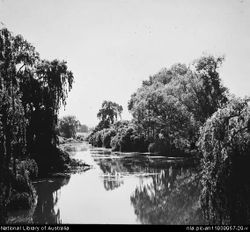
The term Molonglo Plains refers collectively to the flood plains along the entire length of the Molonglo River
Molonglo River
The Molonglo River rises on the western side of the Great Dividing Range of eastern Australia in the state of New South Wales. Its source is on the other side of the mountain range from where the Shoalhaven River rises, in Tallaganda state forest at ~1200 metres altitude...
, including the flood plain located north-east of Queanbeyan on the Molonglo River. The upper Molonglo Plain sometimes referred to as the Hoskinstown Plain is bordered to the east by the low ridges of the Turallo Range, Forbes Creek Ridge and Thurralilly Hill before the steep rise up to the top of the Great Dividing Range.
Upper Molonglo Plain
Some of the Queanbeyan district's most successful rural stations specifically 'Gidleigh', 'Foxlow', 'Carwoola' and 'Primrose Valley' were located on the Molonglo flood plain. 'Foxlow' was established by HC Antill who relinquished the grant to J Hoskins after whom the village of Hoskinstown is named.Lower Molonglo Plain
Prior to Lake Burley Griffin's inception the fertile soils of the Molonglo plain were some of most productive in the Canberra region. John Joshua Moore was the first pastoralist to occupy land on the present site of Canberra, preceding Robert Campbell by about a year. It was, however, only an outstation formed by an overseer and a few convict stockmen. Moore's property took in the present sites of the hospital, of Civic Centre and of the Australian National University and the portions of the Molonglo PlainIn 1843 during a depression he sold the land to Lieutenant Lieutenant Arthur Jeffreys
Acton, Australian Capital Territory
Acton is a suburb of Canberra, Australia. Acton covers an area west of the CBD, bordered by Black Mountain to the west and Lake Burley Griffin in the south...
, R.N., son-in-law of Robert Campbell.
Of the original buildings situated on the former Molonglo Plain, only 'Blundells cottage'
Blundell's Cottage
Blundell's Cottage is a five-roomed stone cottage located on the Southern shore of Lake Burley Griffin, in Canberra, Australia. When it was built this was the Molonglo River floodplain....
remains today. It was constructed in the year 1858 by Robert's son George Campbell for the use of his ploughman William Ginn at a point above the natural flood level, about 400 metres north of the course of the Molonglo River. A number of others building situated near to or on the Molonglo Plain have been lost to Canberra's urban development over the past 70 years. The Klensendorlffe villa is one of the most impressive, a substantial oblong stone ten-roomed stone house, which stood until the mid-1920s near the present site of Albert Hall. The Acton homestead established in about 1843 by Lieutenant Arthur Jeffreys survived until 1941 when it was demolished to make way for the Canberra Community Hospital..
River flow changes
The viability of the floods plains relies of regular flood events that deposit soil and other water borne nutrients onto the plain.The Googong Dam was constructed in 1979 on the Queanbeyan River at a point about 5 km above Queanbeyan. This structure regulates river flows below the junction of the Queanbeyan and Molonglo River. The lower Molonglo River experienced its last major flooding event in 1971.