
Rhinogydd
Encyclopedia
The Rhinogydd are a range of mountain
s located east of Harlech
in North Wales
.
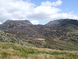
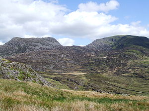 The Rhinogydd are notably rocky and heather
-clad towards the northern end of the range, especially around Rhinog Fawr
, Rhinog Fach
and towards Moel Ysgyfarnogod
. The southern end of the range around Y Llethr
, Diffwys
and the Ysgethin Valley has a more pleasant, grassy character.
A healthy population of wild goat
s can also be found in the range. The name Rhinogydd derives from the names of two of the more famous peaks, Rhinog Fawr
and Rhinog Fach
, although the greatest elevation
in the range is reached by Y Llethr
, 756 m.
Over 30 km²
of the range are protected as a Special Area of Conservation
and a National Nature Reserve
.
age and the area is known geologically as the Harlech dome. This name is derived from the folded, mountainous structure which once extended from Snowdon
in the north to Cader Idris in the south. This dome has long since been eroded, leaving the valleys and peaks of the Rhinogydd visible today. The legacy of this structure can be seen in the slopes of Snowdon and Cader Idris: Snowdon's south face is far steeper than its north face, whilst Cader Idris' north face is steeper than the south.
began work in the area in 1846 and their first maps were published in 1855. With the discovery of gold
in the area in 1846, the state of geological knowledge increased dramatically. At least a dozen major publications appeared between 1844 and 1939.
, Carneddau
and the Snowdon
massif
itself. This is due to the rugged nature of the landscape in the Rhinogydd and the fame of Snowdon
as the highest peak in Wales
. The Rhinog mountains are popular with hillwalkers
looking for a more isolated, wilder walking experience.
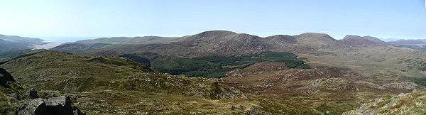
The peaks of the range are most easily accessed from the west
side. Two valleys - Cwm Nantcol
(valley of the Nantcol River) and Cwm Bychan (small valley) - lead deep into the mountains and may be reached from the village of Llanbedr
.
The most popular walking route in this area begins at the Roman Steps at
52°51′16.76"N 4°0′18.43"W, which leads from Cwm Bychan through Bwlch Tyddiad and around Rhinog Fawr
. Despite the name, these steps are not Roman and are in fact the well preserved remains of a medieval pack horse trail leading from Chester
to Harlech Castle
. At the top of the Roman Steps, the route curves around the eastern end of Rhinog Fawr and enters Cwm Nantcol via Bwlch Drws Ardudwy (The Pass of the Doorway of Ardudwy). A different path leads from Cwm Nantcol, passing around the western end of Rhinog Fawr back to Cwm Bychan via Gloywlyn (Gleaming Lake), completing a circular route that can easily be completed in a day.
:
the following Hewitts:
and the following Nuttalls:
Mountain
Image:Himalaya_annotated.jpg|thumb|right|The Himalayan mountain range with Mount Everestrect 58 14 160 49 Chomo Lonzorect 200 28 335 52 Makalurect 378 24 566 45 Mount Everestrect 188 581 920 656 Tibetan Plateaurect 250 406 340 427 Rong River...
s located east of Harlech
Harlech
Harlech is a town and seaside resort in Gwynedd, within the historical boundaries of Merionethshire in northwest Wales. Lying on Tremadog Bay and within the Snowdonia National Park, it has a population of 1,952, of whom 59% speak Welsh...
in North Wales
North Wales
North Wales is the northernmost unofficial region of Wales. It is bordered to the south by the counties of Ceredigion and Powys in Mid Wales and to the east by the counties of Shropshire in the West Midlands and Cheshire in North West England...
.
Calluna
Calluna vulgaris is the sole species in the genus Calluna in the family Ericaceae. It is a low-growing perennial shrub growing to tall, or rarely to and taller, and is found widely in Europe and Asia Minor on acidic soils in open sunny situations and in moderate shade...
-clad towards the northern end of the range, especially around Rhinog Fawr
Rhinog Fawr
Rhinog Fawr is a mountain in Snowdonia, North Wales and forms part of the Rhinogydd range. It is the third highest summit of the Rhinogydd, losing out to Y Llethr and Diffwys respectively...
, Rhinog Fach
Rhinog Fach
Rhinog Fach is a mountain in Snowdonia, North Wales and forms part of the Rhinogydd. Technically, Rhinog Fach is a subsidiary summit of Y Llethr, missing Marilyn status by 3m. Thus making it a sub Marilyn along with Diffwys...
and towards Moel Ysgyfarnogod
Moel Ysgyfarnogod
Moel Ysgyfarnogod is a mountain in Snowdonia, North Wales and is the northernmost of the Rhinogydd. Rhinog Fawr lies directly south....
. The southern end of the range around Y Llethr
Y Llethr
Y Llethr is the highest mountain in the Rhinogydd range of Snowdonia, in north Wales. The summit consists of a flat grassy top marked only by a small cairn...
, Diffwys
Diffwys
Diffwys is a mountain in Snowdonia, North Wales, near Barmouth and forms part of the Rhinogydd. On the north side is an exposure of the Caerdion Syncline. It is technically a subsidiary summit of Y Llethr, missing Marilyn status by 2m. It is therefore like Rhinog Fach a sub Marilyn.The summit has a...
and the Ysgethin Valley has a more pleasant, grassy character.
A healthy population of wild goat
Goat
The domestic goat is a subspecies of goat domesticated from the wild goat of southwest Asia and Eastern Europe. The goat is a member of the Bovidae family and is closely related to the sheep as both are in the goat-antelope subfamily Caprinae. There are over three hundred distinct breeds of...
s can also be found in the range. The name Rhinogydd derives from the names of two of the more famous peaks, Rhinog Fawr
Rhinog Fawr
Rhinog Fawr is a mountain in Snowdonia, North Wales and forms part of the Rhinogydd range. It is the third highest summit of the Rhinogydd, losing out to Y Llethr and Diffwys respectively...
and Rhinog Fach
Rhinog Fach
Rhinog Fach is a mountain in Snowdonia, North Wales and forms part of the Rhinogydd. Technically, Rhinog Fach is a subsidiary summit of Y Llethr, missing Marilyn status by 3m. Thus making it a sub Marilyn along with Diffwys...
, although the greatest elevation
Elevation
The elevation of a geographic location is its height above a fixed reference point, most commonly a reference geoid, a mathematical model of the Earth's sea level as an equipotential gravitational surface ....
in the range is reached by Y Llethr
Y Llethr
Y Llethr is the highest mountain in the Rhinogydd range of Snowdonia, in north Wales. The summit consists of a flat grassy top marked only by a small cairn...
, 756 m.
Over 30 km²
1 E7 m²
To help compare sizes of different geographic regions, we list here areas between 10 km2 and 100 km2...
of the range are protected as a Special Area of Conservation
Special Area of Conservation
A Special Area of Conservation is defined in the European Union's Habitats Directive , also known as the Directive on the Conservation of Natural Habitats and of Wild Fauna and Flora...
and a National Nature Reserve
National Nature Reserve
For details of National nature reserves in the United Kingdom see:*National Nature Reserves in England*National Nature Reserves in Northern Ireland*National Nature Reserves in Scotland*National Nature Reserves in Wales...
.
Geology
The Rhinogydd are formed of hard sedimentary rock of CambrianCambrian
The Cambrian is the first geological period of the Paleozoic Era, lasting from Mya ; it is succeeded by the Ordovician. Its subdivisions, and indeed its base, are somewhat in flux. The period was established by Adam Sedgwick, who named it after Cambria, the Latin name for Wales, where Britain's...
age and the area is known geologically as the Harlech dome. This name is derived from the folded, mountainous structure which once extended from Snowdon
Snowdon
Snowdon is the highest mountain in Wales, at an altitude of above sea level, and the highest point in the British Isles outside Scotland. It is located in Snowdonia National Park in Gwynedd, and has been described as "probably the busiest mountain in Britain"...
in the north to Cader Idris in the south. This dome has long since been eroded, leaving the valleys and peaks of the Rhinogydd visible today. The legacy of this structure can be seen in the slopes of Snowdon and Cader Idris: Snowdon's south face is far steeper than its north face, whilst Cader Idris' north face is steeper than the south.
History of Geological Investigations
The geology of the area was first characterised by Sedwick and Murchinson in 1835. The British Geological SurveyBritish Geological Survey
The British Geological Survey is a partly publicly funded body which aims to advance geoscientific knowledge of the United Kingdom landmass and its continental shelf by means of systematic surveying, monitoring and research. The BGS headquarters are in Keyworth, Nottinghamshire, but other centres...
began work in the area in 1846 and their first maps were published in 1855. With the discovery of gold
Gold
Gold is a chemical element with the symbol Au and an atomic number of 79. Gold is a dense, soft, shiny, malleable and ductile metal. Pure gold has a bright yellow color and luster traditionally considered attractive, which it maintains without oxidizing in air or water. Chemically, gold is a...
in the area in 1846, the state of geological knowledge increased dramatically. At least a dozen major publications appeared between 1844 and 1939.
Hillwalking in the Rhinogydd
The Rhinogydd are far less well known than the areas to the north of the Snowdonia National Park, such as the GlyderauGlyderau
The Glyderau are a mountain group in Snowdonia, North Wales. The name derives from the highest peaks in the range, Glyder Fawr and Glyder Fach....
, Carneddau
Carneddau
The Carneddau , are a group of mountains in Snowdonia, Wales. It includes the largest contiguous areas of high ground in Wales and England, as well as six or seven of the highest peaks in the country—the Fourteen Peaks...
and the Snowdon
Snowdon
Snowdon is the highest mountain in Wales, at an altitude of above sea level, and the highest point in the British Isles outside Scotland. It is located in Snowdonia National Park in Gwynedd, and has been described as "probably the busiest mountain in Britain"...
massif
Massif
In geology, a massif is a section of a planet's crust that is demarcated by faults or flexures. In the movement of the crust, a massif tends to retain its internal structure while being displaced as a whole...
itself. This is due to the rugged nature of the landscape in the Rhinogydd and the fame of Snowdon
Snowdon
Snowdon is the highest mountain in Wales, at an altitude of above sea level, and the highest point in the British Isles outside Scotland. It is located in Snowdonia National Park in Gwynedd, and has been described as "probably the busiest mountain in Britain"...
as the highest peak in Wales
Wales
Wales is a country that is part of the United Kingdom and the island of Great Britain, bordered by England to its east and the Atlantic Ocean and Irish Sea to its west. It has a population of three million, and a total area of 20,779 km²...
. The Rhinog mountains are popular with hillwalkers
Hiking
Hiking is an outdoor activity which consists of walking in natural environments, often in mountainous or other scenic terrain. People often hike on hiking trails. It is such a popular activity that there are numerous hiking organizations worldwide. The health benefits of different types of hiking...
looking for a more isolated, wilder walking experience.
The peaks of the range are most easily accessed from the west
West
West is a noun, adjective, or adverb indicating direction or geography.West is one of the four cardinal directions or compass points. It is the opposite of east and is perpendicular to north and south.By convention, the left side of a map is west....
side. Two valleys - Cwm Nantcol
Cwm Nantcol
Cwm Nantcol is a valley in the Ardudwy area of the county of Gwynedd in Wales.It lies in the Rhinogydd range of mountains in Snowdonia and carries the Afon Cwmnantcol. At the head of Cwn Nantcol is the Bwlch Drws Ardudwy pass, from where it is possible to negotiate the summits of Rhinog Fawr and...
(valley of the Nantcol River) and Cwm Bychan (small valley) - lead deep into the mountains and may be reached from the village of Llanbedr
Llanbedr
Llanbedr is a village in the Ardudwy area of Gwynedd, Wales.The village originally grew around the slate quarrying industry. Attractions in Llanbedr include Neolithic standing stones and Bronze Age hut circles. The Morfa Dyffryn sand dunes and Mochras lie nearby...
.
The most popular walking route in this area begins at the Roman Steps at
52°51′16.76"N 4°0′18.43"W, which leads from Cwm Bychan through Bwlch Tyddiad and around Rhinog Fawr
Rhinog Fawr
Rhinog Fawr is a mountain in Snowdonia, North Wales and forms part of the Rhinogydd range. It is the third highest summit of the Rhinogydd, losing out to Y Llethr and Diffwys respectively...
. Despite the name, these steps are not Roman and are in fact the well preserved remains of a medieval pack horse trail leading from Chester
Chester
Chester is a city in Cheshire, England. Lying on the River Dee, close to the border with Wales, it is home to 77,040 inhabitants, and is the largest and most populous settlement of the wider unitary authority area of Cheshire West and Chester, which had a population of 328,100 according to the...
to Harlech Castle
Harlech Castle
Harlech Castle, located in Harlech, Gwynedd, Wales, is a concentric castle, constructed atop a cliff close to the Irish Sea. Architecturally, it is particularly notable for its massive gatehouse....
. At the top of the Roman Steps, the route curves around the eastern end of Rhinog Fawr and enters Cwm Nantcol via Bwlch Drws Ardudwy (The Pass of the Doorway of Ardudwy). A different path leads from Cwm Nantcol, passing around the western end of Rhinog Fawr back to Cwm Bychan via Gloywlyn (Gleaming Lake), completing a circular route that can easily be completed in a day.
Main peaks
The range contains the following MarilynsMarilyn (hill)
A Marilyn is a mountain or hill in the United Kingdom, Republic of Ireland or Isle of Man with a relative height of at least 150 metres , regardless of absolute height or other merit...
:
- Y LlethrY LlethrY Llethr is the highest mountain in the Rhinogydd range of Snowdonia, in north Wales. The summit consists of a flat grassy top marked only by a small cairn...
756 m - Rhinog FawrRhinog FawrRhinog Fawr is a mountain in Snowdonia, North Wales and forms part of the Rhinogydd range. It is the third highest summit of the Rhinogydd, losing out to Y Llethr and Diffwys respectively...
720 m - Y GarnY Garn (Rhinogydd)For other hills of the same name, see Y Garn .Y Garn is a mountain in the southern Snowdonia, Wales, north of Dolgellau. It is an outlier of the Rhinogydd range, rising above the Coed-y-Brenin forest and the Rhaeadr Du waterfalls. An abandoned gold mine lies on its eastern slopes.-References:...
629 m - Moel YsgyfarnogodMoel YsgyfarnogodMoel Ysgyfarnogod is a mountain in Snowdonia, North Wales and is the northernmost of the Rhinogydd. Rhinog Fawr lies directly south....
623 m - MoelfreMoelfre (hill)Moelfre is a hill in Wales on the far western edge of the Snowdonia National Park, 3 miles from the village of Dyffryn Ardudwy, 5 miles from the village of Llanbedr and about 10 miles from the town of Harlech. It forms part of the Rhinogydd range. Moelfre reaches a height of...
589 m
the following Hewitts:
- Rhinog FachRhinog FachRhinog Fach is a mountain in Snowdonia, North Wales and forms part of the Rhinogydd. Technically, Rhinog Fach is a subsidiary summit of Y Llethr, missing Marilyn status by 3m. Thus making it a sub Marilyn along with Diffwys...
712 m - DiffwysDiffwysDiffwys is a mountain in Snowdonia, North Wales, near Barmouth and forms part of the Rhinogydd. On the north side is an exposure of the Caerdion Syncline. It is technically a subsidiary summit of Y Llethr, missing Marilyn status by 2m. It is therefore like Rhinog Fach a sub Marilyn.The summit has a...
750 m
and the following Nuttalls:
- Crib-y-rhiwCrib-y-rhiwCrib-y-rhiw is a top of Y Llethr and a ridge in the Rhinogydd of Snowdonia, north Wales. The summit stradles a thin ridge connecting Y Llethr to Diffwys....
670 m - Diffwys West TopDiffwys West TopDiffwys West Top is a top of Diffwys in Snowdonia, North Wales, near Barmouth and forms part of the Rhinogydd. It is a gassy summit found on the west ridge. The summit is marked with a pile of stones, below which is the crags of Craig Bodlyn and the glacial lake, Llyn Bodlyn. Moelfre is to the...
642 m - Foel PenolauFoel PenolauFoel Penolau is a top of Moel Ysgyfarnogod in Snowdonia, North Wales and is the northernmost summit of the Rhinogydd. It overlooks Llyn Trawsfynydd, and from the summit it is possible to see the towns of Porthmadog and Blaenau Ffestiniog....
614 m