

Cambrian Mountains
Encyclopedia
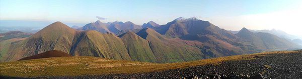
Mountain range
A mountain range is a single, large mass consisting of a succession of mountains or narrowly spaced mountain ridges, with or without peaks, closely related in position, direction, formation, and age; a component part of a mountain system or of a mountain chain...
s in Wales
Wales
Wales is a country that is part of the United Kingdom and the island of Great Britain, bordered by England to its east and the Atlantic Ocean and Irish Sea to its west. It has a population of three million, and a total area of 20,779 km²...
, reaching from, and including, the South Wales
South Wales
South Wales is an area of Wales bordered by England and the Bristol Channel to the east and south, and Mid Wales and West Wales to the north and west. The most densely populated region in the south-west of the United Kingdom, it is home to around 2.1 million people and includes the capital city of...
mountains of the Brecon Beacons
Brecon Beacons
The Brecon Beacons is a mountain range in South Wales. In a narrow sense, the name refers to the range of popular peaks south of Brecon, including South Wales' highest mountain, Pen y Fan, and which together form the central section of the Brecon Beacons National Park...
, north Carmarthenshire
Carmarthenshire
Carmarthenshire is a unitary authority in the south west of Wales and one of thirteen historic counties. It is the 3rd largest in Wales. Its three largest towns are Llanelli, Carmarthen and Ammanford...
and Ceredigion
Ceredigion
Ceredigion is a county and former kingdom in mid-west Wales. As Cardiganshire , it was created in 1282, and was reconstituted as a county under that name in 1996, reverting to Ceredigion a day later...
, the Black Mountains
Black Mountains, Wales
The Black Mountains are a group of hills spread across parts of Powys and Monmouthshire in southeast Wales, and extending across the national border into Herefordshire, England. They are the easternmost of the four ranges of hills that comprise the Brecon Beacons National Park, and are frequently...
of eastern Wales, to Snowdonia
Snowdonia
Snowdonia is a region in north Wales and a national park of in area. It was the first to be designated of the three National Parks in Wales, in 1951.-Name and extent:...
in North Wales
North Wales
North Wales is the northernmost unofficial region of Wales. It is bordered to the south by the counties of Ceredigion and Powys in Mid Wales and to the east by the counties of Shropshire in the West Midlands and Cheshire in North West England...
. They range in height up to more than 3000 feet in Snowdonia, while the southern ranges are of lesser height. They include volcanic rock
Volcanic rock
Volcanic rock is a rock formed from magma erupted from a volcano. In other words, it is an igneous rock of volcanic origin...
s in Snowdonia, while the southern mountains are mainly of sedimentary origin, such as red sandstone
Sandstone
Sandstone is a sedimentary rock composed mainly of sand-sized minerals or rock grains.Most sandstone is composed of quartz and/or feldspar because these are the most common minerals in the Earth's crust. Like sand, sandstone may be any colour, but the most common colours are tan, brown, yellow,...
and carboniferous limestone
Carboniferous limestone
Carboniferous Limestone is a term used to describe a variety of different types of limestone occurring widely across Great Britain and Ireland which were deposited during the Dinantian epoch of the Carboniferous period. They were formed between 363 and 325 million years ago...
. All the ranges are popular with hillwalkers and scrambler
Scrambler
In telecommunications, a scrambler is a device that transposes or inverts signals or otherwise encodes a message at the transmitter to make the message unintelligible at a receiver not equipped with an appropriately set descrambling device...
s.
Since they face the predominant westerly air stream coming in from the Atlantic ocean
Atlantic Ocean
The Atlantic Ocean is the second-largest of the world's oceanic divisions. With a total area of about , it covers approximately 20% of the Earth's surface and about 26% of its water surface area...
, they exhibit high rainfall and are the source of numerous rivers, among which the Severn river is by far the largest. It rises in central Wales.
Central Region
Wales
Wales is a country that is part of the United Kingdom and the island of Great Britain, bordered by England to its east and the Atlantic Ocean and Irish Sea to its west. It has a population of three million, and a total area of 20,779 km²...
. Since the 1950s, its application has become increasingly (and arguably illogically) localised to the geographically homogeneous Mid Wales uplands known in the Welsh language
Welsh language
Welsh is a member of the Brythonic branch of the Celtic languages spoken natively in Wales, by some along the Welsh border in England, and in Y Wladfa...
as the Elenydd
Elenydd
Elenydd is a Site of Special Scientific Interest in Ceredigion, west Wales....
(which extend from Pumlumon to Mynydd Mallaen).
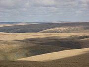
This barren and sparsely populated wilderness is often referred to affectionately as the Desert of Wales
Desert of Wales
The Desert of Wales is a term coined to describe a large area in central Wales, so called because of its lack of roads and towns and its inaccessibility. The term was invented by English travel writers in the nineteenth century and its equivalent is not found in the Welsh language...
.
The highest point of the range is Pumlumon. The area includes the source of the River Severn
River Severn
The River Severn is the longest river in Great Britain, at about , but the second longest on the British Isles, behind the River Shannon. It rises at an altitude of on Plynlimon, Ceredigion near Llanidloes, Powys, in the Cambrian Mountains of mid Wales...
and River Wye
River Wye
The River Wye is the fifth-longest river in the UK and for parts of its length forms part of the border between England and Wales. It is important for nature conservation and recreation.-Description:...
, and has been proposed as a National Park
National parks of England and Wales
The national parks of England and Wales are areas of relatively undeveloped and scenic landscape that are designated under the National Parks and Access to the Countryside Act 1949...
. It is the type of locality of the Cambrian
Cambrian
The Cambrian is the first geological period of the Paleozoic Era, lasting from Mya ; it is succeeded by the Ordovician. Its subdivisions, and indeed its base, are somewhat in flux. The period was established by Adam Sedgwick, who named it after Cambria, the Latin name for Wales, where Britain's...
period of the Paleozoic era (542-488Ma).
The Cambrian Mountains can also be seen to be continuous into parts of England
England
England is a country that is part of the United Kingdom. It shares land borders with Scotland to the north and Wales to the west; the Irish Sea is to the north west, the Celtic Sea to the south west, with the North Sea to the east and the English Channel to the south separating it from continental...
, across the Anglo-Welsh border in parts of Shropshire, particularly around the Shropshire Hills AONB
Shropshire Hills AONB
The Shropshire Hills area is designated as an Area of Outstanding Natural Beauty , in the English county of Shropshire, close to its border with Wales. Designated in 1958 , the area encompasses of land primarily in south-west Shropshire...
, Black Mountain (hill)
Black Mountain (hill)
Twyn Llech also known as Black Mountain is a mountain in the Black Mountains . It is the only Marilyn to fall exactly on the Welsh-English border, straddling Powys and Herefordshire...
, Clun Forest
Clun Forest
Clun Forest is a remote, rural area of open pastures, moorland and mixed deciduous/coniferous woodland in the southwest part of the English county of Shropshire and also just over the border into Powys, Wales....
and the Long Mynd
Long Mynd
The Long Mynd in Shropshire, England, is a part of the Shropshire Hills Area of Outstanding Natural Beauty. It is south of the county town Shrewsbury, and has an area of over 22 square kilometres , most of which takes the form of a heathland plateau. Most of the land on the Long Mynd is owned by...
areas.

Dams and Wind Farms
Cefn CroesCefn Croes
Cefn Croes is a wind farm in Ceredigion, Wales. It is located in the Cambrian Mountains, just south of the A44 road between Aberystwyth and Llangurig, in west Wales. The construction of the wind farm commenced in February 2004, and was completed in the spring of 2005 when the 39 wind turbines...
, the site of a controversial wind farm
Wind farm
A wind farm is a group of wind turbines in the same location used to produce electric power. A large wind farm may consist of several hundred individual wind turbines, and cover an extended area of hundreds of square miles, but the land between the turbines may be used for agricultural or other...
project, is in the Cambrian Mountains, just south of the A44 road
A44 road
The A44 is a major road in the United Kingdom that runs from Oxford in southern England to Aberystwyth in west Wales.-History:The original route of the A44 was Chipping Norton to Aberystwyth. No changes were made to the route of the A44 in the early years...
between Aberystwyth
Aberystwyth
Aberystwyth is a historic market town, administrative centre and holiday resort within Ceredigion, Wales. Often colloquially known as Aber, it is located at the confluence of the rivers Ystwyth and Rheidol....
and Llangurig
Llangurig
Llangurig is a village in Powys, within the historic county boundaries of Montgomeryshire, mid Wales, lying on the River Wye. The population is 670.Llangurig is reputed to be the highest village in Wales at an altitude of 1000 feet...
.http://www.power-technology.com/projects/cefn_croes/, http://www.power-technology.com/projects/cefn_croes/cefn_croes5.html,http://www.users.globalnet.co.uk/~hills/cc/
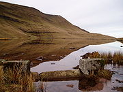
The Cambrian Mountains host the Elan Valley Reservoirs
Elan Valley Reservoirs
The Elan Valley Reservoirs are a chain of man-made lakes and reservoirs in the Elan Valley in Powys, Mid Wales , using the rivers Elan and Claerwen...
and Llyn Brianne
Llyn Brianne
Llyn Brianne is a man-made lake or reservoir in the headwaters of the River Tywi in central Wales.-Construction:The reservoir was constructed by Wimpey Construction in the late 1960s and early 1970s in order to regulate the flow in the River Tywi to support large potable water abstraction at...
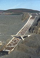
reservoir, which provide water for the English West Midlands and for South Wales respectively. They include the Clywedog Reservoir
Clywedog reservoir
The Clywedog reservoir is a reservoir in the Welsh county of Powys, located off the B4518 road near the town of Llanidloes.The reservoir was formed by damming the Afon Clywedog, a tributary of the River Severn. Its concrete buttress dam is the tallest concrete dam in the United Kingdom, with a...
and Nant y Moch
Nant y Moch
Nant-y-moch Reservoir is situated in the Cambrian Mountains in northern Ceredigion, Wales. The reservoir which flooded a part of the valley of the River Rheidol and its headwaters derives its name from a stream, the Nant-y-moch , which formerly flowed into the River Rheidol at this spot. The dam...
Reservoir.
Principal Cambrian Mountain Summits
- Pen Pumlumon Fawr [Plynlimon] 752m
- Pen Pumlumon ArwystliPen Pumlumon ArwystliPen Pumlumon Arwystli is the second highest point on the Plynlimon massif, a part of the Cambrian Mountains in the county of Ceredigion, Wales.The summit is grassy, and is marked by 3 large ancient cairns...
741m - Pen Pumlumon Llygad-bychanPen Pumlumon Llygad-bychanPen Pumlumon Llygad-bychan is a subsidiary summit of Pen Pumlumon Fawr and the third highest point on the Plynlimon massif, a part of the Cambrian Mountains in the county of Ceredigion, Wales.The summit is boggy, and is marked by a few stones...
727m - Y GarnY Garn (Plynlimon)Y Garn is a subsidiary summit of Pen Pumlumon Fawr and the fourth highest peak on the Plynlimon massif, a part of the Cambrian Mountains in the county of Ceredigion, Wales.The summit is marked by a large shelter cairn, hollowed out from an ancient burial cairn...
684m - Pumlumon FachPumlumon FachPumlumon Fach is a top of Pen Pumlumon Fawr on the Plynlimon massif, a part of the Cambrian Mountains in the county of Ceredigion, Wales. It lies on small ridge heading north-west from the summit of Pen Pumlumon Fawr....
668m - Great Rhos 660m
- Black MixenBlack MixenBlack Mixen is a subsidiary summit of Rhos Fawr or Great Rhos, in the Radnor Forest. The summit is large peat bog plateau. The summit is marked with a cairn, and is next to a radio transmitter and its building....
650m - Drygarn FawrDrygarn FawrDrygarn Fawr is a mountain in the county of Powys, Wales. It is one of the highest summits in Mid Wales standing at 645 metres above sea level. Rising above the remote moorland plateau of the Cambrian Mountains, the summit is topped by two distinctive, large cairns. The mountain has a gentle,...
645m - GorllwynGorllwynGorllwyn is a subsidiary summit of Drygarn Fawr, located on a remote moorland plateau of the Cambrian Mountains. The summit is grassy and is surrounded by peat bog. There is a shelter cairn and a trig point....
613m - Bache HillBache HillBache Hill is a subsidiary summit of Rhos Fawr or Great Rhos, in the Radnor Forest in Wales. It is located to the east of Black Mixen. The summit is marked by a trig point built on an ancient burial mound....
610m - Pen y GarnPen y GarnPen y Garn is one of the highest mountains in Mid Wales standing at 610 metres above sea level. It is one of the Cambrian Mountains.It tops a 500–600 m high plateau situated on which is the controversial Cefn Coch wind farm. The summit has a very large shelter cairn hollowed out from the...
610m - Y Gamriw 604m
- Llan Ddu FawrLlan Ddu FawrLlan Ddu Fawr is one of the highest summits in Ceredigion, Wales, at . It is located about 10 miles south of Plynlimon. The surrounding land can be very boggy. There is a trig point at the summit....
593m - Pegwn MawrPegwn MawrPegwn Mawr is a mountain in Powys, Mid Wales, east of Llanidloes. It is 586 m high. It is surrounded by a wind farm....
586m
See also
- The Cambrian WayCambrian WayThe Cambrian Way is a long distance footpath in Wales running from Cardiff to Conwy.-The route:The route is not waymarked. It therefore requires advanced map reading and navigational experience...
high level long-distance footpath