
Moel Siabod
Encyclopedia
Moel Siabod is a mountain
in Snowdonia
, North Wales
, which sits isolated above the villages of Betws-y-Coed
and Capel Curig
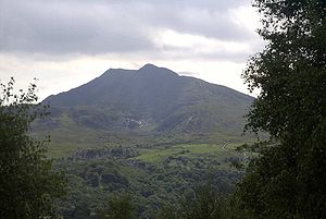
. At 872m it is the highest peak in the Moelwynion
mountain range. The UK National Mountain Centre, Plas-y-Brenin, is located at the foot of Moel Siabod. From the top of the mountain, it is reputedly possible to see 13 of the 14 highest peaks in Wales
on a clear day without turning one's head. The words Moel Siabod translate from Welsh as Scabby Hill.
and nearby Pont Cyfyng (by a separate but similar path) and from the south via Dolwyddelan
.
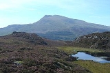
The north-west side of the main ridge is relatively gentle and supports a variety of flora and has numerous paths. The south-east side has many sharp drops down to a hanging valley. This valley, fenced in on two sides by the main ridge and the ridge running east from the summit, is at roughly 500 m above sea level and contains Llyn-y-foel
(Welsh
for lake of the mountain). There is both a steep descent, following a stream
that emerges from the lake to the south-east, and a gentle descent, to the north-east, from this valley.
map. All of the paths below, excluding the route from Llyn-y-foel directly onto the minor ridge, are marked on the 'Snowdonia Snowdon and the Moelwynion' Harvey SuperWalker map.
, and is therefore used for guided excursions. It is the gentlest of the three most common routes and is the only one marked on the OS maps.
Leaving the centre, you crosses the river Llygwy via the ancient bridge "Pont-y-Bala", the path almost immediately enters Forestry Commission
land and follows a variety of dirt tracks and footpaths before exiting onto open access land and continuing south up the grassy northern side of the mountain.
 A well marked in the village of Pont Cyfyng onto a very steep tarmacked road marks the beginning of this path, Not the one with the pedestrian sign by it, with a footpath leaving the road after about 100 m. This footpath forks, with one route taking a sharp ascent onto the main ridge and one a more gentle route up through an abandoned slate
mine and up to Llyn-y-foel
(see above) from which there are several paths to the summit not marked on the OS map via the minor ridge to the east of the summit. See below - paths from Llyn-y-foel to the summit
land to the north of Dolwyddelan
and the south of the mountain. Along the dirt tracks through this land there is a fork signposted "Moel Siabod" (left) or "Capel Curig" (right). The latter path leads first of all to Pont Cyfyng, where it is possible to join the path above, or continue to Capel Curig and join the first route. The former path is a more direct route to the summit. This path continues on dirt tracks for a while before heading onto a footpath through the forest and thence onto access land. At this point, the path - which occasionally requires the use of hands to get up the rocky path - follows a stream which originates at Llyn-y-foel.
directly onto the ridge from the lake.
Mountain
Image:Himalaya_annotated.jpg|thumb|right|The Himalayan mountain range with Mount Everestrect 58 14 160 49 Chomo Lonzorect 200 28 335 52 Makalurect 378 24 566 45 Mount Everestrect 188 581 920 656 Tibetan Plateaurect 250 406 340 427 Rong River...
in Snowdonia
Snowdonia
Snowdonia is a region in north Wales and a national park of in area. It was the first to be designated of the three National Parks in Wales, in 1951.-Name and extent:...
, North Wales
Wales
Wales is a country that is part of the United Kingdom and the island of Great Britain, bordered by England to its east and the Atlantic Ocean and Irish Sea to its west. It has a population of three million, and a total area of 20,779 km²...
, which sits isolated above the villages of Betws-y-Coed
Betws-y-Coed
Betws-y-Coed is a village and community in the Conwy valley in Conwy County Borough, Wales. It has a population of 534. The name Betws or Bettws is generally thought to be derived from the Anglo-Saxon Old English 'bed-hus' - i.e. a bead-house - a house of prayer, or oratory...
and Capel Curig
Capel Curig
Capel Curig is a village and community in Conwy County Borough, in Wales. It lies in the heart of Snowdonia, on the River Llugwy, and has a population of 226...
. At 872m it is the highest peak in the Moelwynion
Moelwynion
The Moelwynion are a group of mountains in central Snowdonia. They extend from the north-east of Porthmadog to Moel Siabod, the highest of the group...
mountain range. The UK National Mountain Centre, Plas-y-Brenin, is located at the foot of Moel Siabod. From the top of the mountain, it is reputedly possible to see 13 of the 14 highest peaks in Wales
Welsh 3000s
This is a list of what are known as the Welsh 3000s, i.e. those 15 mountains in Wales which have a height of 3000 ft or more. Geographically they fall within three ranges, all sufficiently close to make it possible to reach all 15 summits within 24 hours, a challenge known as the Welsh 3000s...
on a clear day without turning one's head. The words Moel Siabod translate from Welsh as Scabby Hill.
Access
The mountain is easily accessible from the north via Capel CurigCapel Curig
Capel Curig is a village and community in Conwy County Borough, in Wales. It lies in the heart of Snowdonia, on the River Llugwy, and has a population of 226...
and nearby Pont Cyfyng (by a separate but similar path) and from the south via Dolwyddelan
Dolwyddelan
Dolwyddelan, Welsh language : 'the meadow of Gwyddelan', is a village and community in Conwy county borough, north Wales, on the main A470 road between Blaenau Ffestiniog and Betws-y-Coed...
.
Topography
The highest part of the mountain forms a relatively level, rocky ridge approximately 800 m long, running roughly south-west (from the summit) to north-east. At the north-eastern end of this main ridge there is a fairly steep descent towards Pont Cyfyng. At the south-west edge of the main ridge there is a further, much steeper ridge that branches off to the east, as well as several precipitous cliffs.The north-west side of the main ridge is relatively gentle and supports a variety of flora and has numerous paths. The south-east side has many sharp drops down to a hanging valley. This valley, fenced in on two sides by the main ridge and the ridge running east from the summit, is at roughly 500 m above sea level and contains Llyn-y-foel
Llyn-y-foel
Llyn-y-Foel is a lake in Snowdonia, Wales. It is approximately 240 m across, 120 m wide and up to 2 m deep. It lies at 535m altitude at the foot of the main ridge of Moel Siabod at ....
(Welsh
Welsh language
Welsh is a member of the Brythonic branch of the Celtic languages spoken natively in Wales, by some along the Welsh border in England, and in Y Wladfa...
for lake of the mountain). There is both a steep descent, following a stream
Stream
A stream is a body of water with a current, confined within a bed and stream banks. Depending on its locale or certain characteristics, a stream may be referred to as a branch, brook, beck, burn, creek, "crick", gill , kill, lick, rill, river, syke, bayou, rivulet, streamage, wash, run or...
that emerges from the lake to the south-east, and a gentle descent, to the north-east, from this valley.
Terrain
As mentioned above, the two main ridges are fairly rocky; an ascent up the minor ridge will usually require either the use of hands, as will the ascent to Llyn-y-foel from the Dolwyddelan path. The terrain around the lake is prone to be boggy, especially on the northern side, and the path to the lake from Pont Cyfyng frequently turns into a flowing stream.Paths
There are several routes to the top of Moel Siabod, only one of which is marked on the local Ordnance SurveyOrdnance Survey
Ordnance Survey , an executive agency and non-ministerial government department of the Government of the United Kingdom, is the national mapping agency for Great Britain, producing maps of Great Britain , and one of the world's largest producers of maps.The name reflects its creation together with...
map. All of the paths below, excluding the route from Llyn-y-foel directly onto the minor ridge, are marked on the 'Snowdonia Snowdon and the Moelwynion' Harvey SuperWalker map.
From Capel Curig
The most popular route starts from the Plas-y-Brenin National Mountaineering Centre in Capel CurigCapel Curig
Capel Curig is a village and community in Conwy County Borough, in Wales. It lies in the heart of Snowdonia, on the River Llugwy, and has a population of 226...
, and is therefore used for guided excursions. It is the gentlest of the three most common routes and is the only one marked on the OS maps.
Leaving the centre, you crosses the river Llygwy via the ancient bridge "Pont-y-Bala", the path almost immediately enters Forestry Commission
Forestry Commission
The Forestry Commission is a non-ministerial government department responsible for forestry in Great Britain. Its mission is to protect and expand Britain's forests and woodlands and increase their value to society and the environment....
land and follows a variety of dirt tracks and footpaths before exiting onto open access land and continuing south up the grassy northern side of the mountain.
From Pont Cyfyng
Slate
Slate is a fine-grained, foliated, homogeneous metamorphic rock derived from an original shale-type sedimentary rock composed of clay or volcanic ash through low-grade regional metamorphism. The result is a foliated rock in which the foliation may not correspond to the original sedimentary layering...
mine and up to Llyn-y-foel
Llyn-y-foel
Llyn-y-Foel is a lake in Snowdonia, Wales. It is approximately 240 m across, 120 m wide and up to 2 m deep. It lies at 535m altitude at the foot of the main ridge of Moel Siabod at ....
(see above) from which there are several paths to the summit not marked on the OS map via the minor ridge to the east of the summit. See below - paths from Llyn-y-foel to the summit
From Dolwyddelan
A large part of the horizontal distance covered on this route is on Forestry CommissionForestry Commission
The Forestry Commission is a non-ministerial government department responsible for forestry in Great Britain. Its mission is to protect and expand Britain's forests and woodlands and increase their value to society and the environment....
land to the north of Dolwyddelan
Dolwyddelan
Dolwyddelan, Welsh language : 'the meadow of Gwyddelan', is a village and community in Conwy county borough, north Wales, on the main A470 road between Blaenau Ffestiniog and Betws-y-Coed...
and the south of the mountain. Along the dirt tracks through this land there is a fork signposted "Moel Siabod" (left) or "Capel Curig" (right). The latter path leads first of all to Pont Cyfyng, where it is possible to join the path above, or continue to Capel Curig and join the first route. The former path is a more direct route to the summit. This path continues on dirt tracks for a while before heading onto a footpath through the forest and thence onto access land. At this point, the path - which occasionally requires the use of hands to get up the rocky path - follows a stream which originates at Llyn-y-foel.
Paths from Llyn-y-foel to the summit
There are numerous tracks around the lake which will allow a walker to get from any point at the lake to any other without too much trouble. The main route from the lake to the summit heads to the south of the lake and then turns sharply right and ascends the minor ridge to the summit. There is a further, more obscure path that ascends very steeply over rockfalls and some screeScree
Scree, also called talus, is a term given to an accumulation of broken rock fragments at the base of crags, mountain cliffs, or valley shoulders. Landforms associated with these materials are sometimes called scree slopes or talus piles...
directly onto the ridge from the lake.
External links
- Computer generated summit panoramas North
- Video of Gwilym Jones, Hill farmer of Moel Siabod
- South index
- www.geograph.co.uk : photos of Moel Siabod and surrounding area