
Geography of the Philippines
Encyclopedia
Philippines
The Philippines , officially known as the Republic of the Philippines , is a country in Southeast Asia in the western Pacific Ocean. To its north across the Luzon Strait lies Taiwan. West across the South China Sea sits Vietnam...
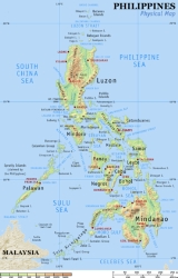
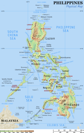
is an archipelago comprising 7,107 islands with a total land area of 300,000 km2. The 11 largest islands contain 94% of the total land area. The largest of these islands is Luzon
Luzon
Luzon is the largest island in the Philippines. It is located in the northernmost region of the archipelago, and is also the name for one of the three primary island groups in the country centered on the Island of Luzon...
at about 105,000 km2. The next largest island is Mindanao
Mindanao
Mindanao is the second largest and easternmost island in the Philippines. It is also the name of one of the three island groups in the country, which consists of the island of Mindanao and smaller surrounding islands. The other two are Luzon and the Visayas. The island of Mindanao is called The...
at about 95,000 km2. The archipelago is around 800 km from the Asia
Asia
Asia is the world's largest and most populous continent, located primarily in the eastern and northern hemispheres. It covers 8.7% of the Earth's total surface area and with approximately 3.879 billion people, it hosts 60% of the world's current human population...
n mainland and is located between Taiwan
Taiwan
Taiwan , also known, especially in the past, as Formosa , is the largest island of the same-named island group of East Asia in the western Pacific Ocean and located off the southeastern coast of mainland China. The island forms over 99% of the current territory of the Republic of China following...
and Borneo
Borneo
Borneo is the third largest island in the world and is located north of Java Island, Indonesia, at the geographic centre of Maritime Southeast Asia....
.
The islands are divided into three groups: Luzon
Luzon
Luzon is the largest island in the Philippines. It is located in the northernmost region of the archipelago, and is also the name for one of the three primary island groups in the country centered on the Island of Luzon...
, Visayas
Visayas
The Visayas or Visayan Islands and locally known as Kabisay-an gid, is one of the three principal geographical divisions of the Philippines, along with Mindanao and Luzon. It consists of several islands, primarily surrounding the Visayan Sea, although the Visayas are considered the northeast...
, and Mindanao
Mindanao
Mindanao is the second largest and easternmost island in the Philippines. It is also the name of one of the three island groups in the country, which consists of the island of Mindanao and smaller surrounding islands. The other two are Luzon and the Visayas. The island of Mindanao is called The...
. The Luzon islands include Luzon Island itself, Palawan
Palawan Island
Palawan Island is the largest island of the Palawan Province, Philippines. The northern coast of the island is along the South China Sea, while the southern coast forms part of the northern limit of the Sulu Sea. This island is very undeveloped and traditional...
, Mindoro, Marinduque
Marinduque
In 1945, combined American and Philippine Commonwealth troops attacked from the Japanese Troops liberated to the Battle of Marinduque in the Second World War.-Archaeology:...
, Masbate
Masbate Island
Masbate is one of the three major islands of Masbate Province in the Philippines. The other two major Islands are Ticao Island and Burias Island. It is the world's 155th largest island according to area and the world's 59th largest island according to population.Masbate Related Website...
and Batanes Islands. The Visayas is the group of islands in the central Philippines, the largest of which are: Panay
Panay Island
Panay is an island in the Philippines located in the western part of the Visayas. Politically, it is divided into five provinces: Aklan, Antique, Capiz, and Iloilo, all in the Western Visayas Region. It is located southeast of the island of Mindoro and northwest of Negros, separated by the...
, Negros, Cebu
Cebu Island
Cebu is an island of the Philippines. It is the main island of Cebu Province at the center of the Visayan Islands, south of Manila.It lies to the east of Negros Island; to the east is Leyte and to the southeast is Bohol Island. It is flanked on both sides by the Cebu Strait and Tañon Strait...
, Bohol
Bohol Island
Bohol Island is the main island of Bohol Province in the Visayas. It lies southeast from Cebu Island across Cebu Strait and southwest from Leyte Island, separated by the Camotes Sea and Canigao Channel...
, Leyte
Leyte Island
Leyte is an island in the Visayas group of the Philippines.The island measures about 180 km north-south and about 65 km at its widest point. In the north it nearly joins Samar, separated by the San Juanico Strait, which becomes as narrow as 2 km in some places...
and Samar
Samar Island
Samar is an island in the Visayas, within the central Philippines. The island is divided into three provinces: Samar province, Northern Samar, and Eastern Samar. These three provinces, along with the provinces on the nearby islands of Leyte and Biliran are part of the Eastern Visayas region...
. The Mindanao islands include Mindanao itself, plus the Sulu Archipelago
Sulu Archipelago
The Sulu Archipelago is a chain of islands in the southwestern Philippines. This archipelago is considered to be part of the Moroland by the local rebel independence movement. This island group forms the northern limit of the Celebes Sea....
, composed primarily of Basilan
Basilan
The Province of Basilan is an island province of the Philippines within the Autonomous Region in Muslim Mindanao . Basilan is the largest and northernmost of the major islands of the Sulu Archipelago and is located just off the southern coast of Zamboanga Peninsula...
, Sulu Island, and Tawi-Tawi
Tawi-Tawi
Tawi-Tawi is an island province of the Philippines located in the Autonomous Region in Muslim Mindanao . The capital of Tawi-Tawi is Bongao. The province is the southernmost of the country sharing sea borders with the Malaysian State of Sabah and the Indonesian East Kalimantan province. To the...
.
Physical setting
Exclusive Economic Zone
Under the law of the sea, an exclusive economic zone is a seazone over which a state has special rights over the exploration and use of marine resources, including production of energy from water and wind. It stretches from the seaward edge of the state's territorial sea out to 200 nautical...
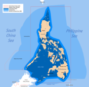
(EEZ) of 200 nautical miles (370.4 km) from its shores. The Philippines occupies an area that stretches for 1,850 kilometers from about the fifth to the twentieth parallels north latitude. The total land area is slightly more than 300,000 square kilometers. Only approximately 1,000 of its islands are populated, and fewer than one-half of these are larger than 2.5 square kilometers. Eleven islands make up 95 percent of the Philippine landmass, and two of these — Luzon and Mindanao — measure 105,000 and 95,000 square kilometers, respectively. They, together with the cluster of the Visayan Islands that separate them, represent the three principal regions of the archipelago that are identified by the three stars on the Philippine flag. Topographically, the Philippines is broken up by the sea, which gives it one of the longest coastlines of any nation in the world. Most Filipinos live on or near the coast, where they can easily supplement their diet from approximately 2,000 species of fish.
Off the coast of eastern Mindanao is the Philippine Trough, which descends to a depth of 10,430 meters. The Philippines is part of a western Pacific arc system that is characterized by active volcanoes. Among the most notable peaks are Mount Mayon near Legazpi City
Legazpi City
The City of Legazpi is a first class city and capital of the province of Albay, Philippines. With 179,481 inhabitants according to the 2007 census, it is the largest city in the Bicol Region in terms of population, though not in land area...
, Taal Volcano
Taal Volcano
Taal Volcano is a complex volcano located on the island of Luzon in the Philippines. Historical eruptions are concentrated on Volcano Island, an island near the middle of Lake Taal. The lake partially fills Taal Caldera, which was formed by powerful prehistoric eruptions between 140,000 to 5,380 BP...
south of Manila
Manila
Manila is the capital of the Philippines. It is one of the sixteen cities forming Metro Manila.Manila is located on the eastern shores of Manila Bay and is bordered by Navotas and Caloocan to the north, Quezon City to the northeast, San Juan and Mandaluyong to the east, Makati on the southeast,...
, and Mount Apo
Mount Apo
Mount Apo is a large solfataric, potentially-active stratovolcano in the island of Mindanao, Philippines. With an altitude of , it is the highest mountain in the country and is located between Davao City and Davao del Sur province in Region XI and Cotabato province in Region XII...
on Mindanao. All of the Philippine islands are prone to earthquakes. The northern Luzon highlands, or Cordillera Central, rise to between 2,500 and 2,750 meters, and, together with the Sierra Madre in the northeastern portion of Luzon and the mountains of Mindanao, boast rain forests that provide refuge for numerous upland tribal groups. The rain forests also offer prime habitat for more than 500 species of birds, including the Philippine eagle
Philippine Eagle
The Philippine Eagle , also known as the Monkey-eating Eagle, is an eagle of the family Accipitridae that is endemic to forests in the Philippines. It has brown and white-coloured plumage, and a shaggy crest, and generally measures in length and weighs...
(or monkey-eating eagle), some 800 species of orchids, and some 8,500 species of flowering plants.
The country's most extensive river systems are the Pulangi River
Pulangi River
The Pulangi River , also spelled Pulangui, is the longest river in Bukidnon. It is one of the major tributaries of the Rio Grande de Mindanao, an extensive river system in Mindanao, Philippines...
, which flows into the Mindanao River
Mindanao River
The Mindanao River, also known as the Rio Grande de Mindanao, is the second largest river system in the Philippines, after the Cagayan River of Luzon. It is also the largest river on the southern Philippine island of Mindanao having a drainage area of 23,169 square kilometers, draining majority of...
(Rio Grande de Mindanao); the Agusan
Agusan River
Agusan River is a river located in the eastern part of Mindanao island in the Philippines, draining majority of the Caraga Region and some parts of Compostela Valley province. It is the third largest river basin of the Philippines with a total drainage area of 10,921 km² and an estimated...
, in Mindanao which flows north into the Mindanao Sea; the Cagayan
Cagayan River
The Cagayan River is the longest and largest river in the Philippine Archipelago. It is located in the Cagayan Valley region in northeastern part of Luzon island and traverses the provinces of Nueva Vizcaya, Quirino, Isabela and Cagayan.-Topography:...
in northern Luzon; and the Pampanga
Pampanga River
Pampanga River is the second largest river in the island of Luzon, next to Cagayan River and the third largest river in the Philippines...
, which flows south from east Central Luzon into Manila Bay
Manila Bay
Manila Bay is a natural harbor which serves the Port of Manila , in the Philippines.The bay is considered to be one of the best natural harbors in Southeast Asia and one of the finest in the world...
. Laguna de Bay
Laguna de Bay
Laguna de Bay is the largest lake in the Philippines and the third largest freshwater lake in Southeast Asia after Tonle Sap in Cambodia and Lake Toba in Sumatra, Indonesia. It is on the island of Luzon between the provinces of Laguna to the south and Rizal to the north...
, east of Manila Bay, is the largest freshwater lake in the Philippines. Several rivers have been harnessed for hydroelectric power.
To protect the country's biological resources, the government has taken a first step of preparing a Biodiversity Action Plan
Biodiversity Action Plan
A Biodiversity Action Plan is an internationally recognized program addressing threatened species and habitats and is designed to protect and restore biological systems. The original impetus for these plans derives from the 1992 Convention on Biological Diversity...
to address conservation of threatened species
Species
In biology, a species is one of the basic units of biological classification and a taxonomic rank. A species is often defined as a group of organisms capable of interbreeding and producing fertile offspring. While in many cases this definition is adequate, more precise or differing measures are...
.
Political geography
The Philippines is divided into a hierarchy of local government units (LGUs) with the 81 provincesProvinces of the Philippines
The Provinces of the Philippines are the primary political and administrative divisions of the Philippines. There are 80 provinces at present, further subdivided into component cities and municipalities. The National Capital Region, as well as independent cities, are autonomous from any provincial...
as the primary unit. Provinces are further subdivided into cities
Cities of the Philippines
A city is a tier of local government in the Philippines. All Philippine cities are chartered cities, whose existence as corporate and administrative entities is governed by their own specific charters in addition to the Local Government Code of 1991, which specifies the administrative structure...
and municipalities, which are in turn composed of barangay
Barangay
A barangay is the smallest administrative division in the Philippines and is the native Filipino term for a village, district or ward...
s. The barangay is the smallest local government unit.
The Philippines is divided into 17 regions with all provinces grouped into one of 16 regions
Regions of the Philippines
In the Philippines, regions are administrative divisions that serve primarily to organize the provinces of the country for administrative convenience. Currently, the archipelagic republic of the Philippines is divided into 17 regions...
for administrative convenience. The National Capital Region
Metro Manila
Metropolitan Manila , the National Capital Region , or simply Metro Manila, is the metropolitan region encompassing the City of Manila and its surrounding areas in the Philippines...
however, is divided into four special districts.
Most government offices establish regional offices to serve the constituent provinces. The regions themselves do not possess a separate local government, with the exception of the Autonomous Region in Muslim Mindanao
Autonomous Region in Muslim Mindanao
The Autonomous Region in Muslim Mindanao is the region, located in the Mindanao island group of the Philippines, that is composed of predominantly Muslim provinces, namely: Basilan , Lanao del Sur, Maguindanao, Sulu and Tawi-Tawi. It is the only region that has its own government...
.
Regions
- Ilocos RegionIlocos RegionThe Ilocos region or Region I is a Region of the Philippines and is located in the northwest of Luzon. It borders to the east the regions of the Cordillera Administrative Region and Cagayan Valley and to the south the region of Central Luzon...
(Region I) - Cagayan ValleyCagayan ValleyCagayan Valley is a region of the Philippines, also designated as Region II or Region 02. It is composed of five provinces, namely: Batanes, Cagayan, Isabela, Nueva Vizcaya, and Quirino...
(Region II) - Central LuzonCentral LuzonCentral Luzon , also known as Region III , is an administrative division or region of the Republic of the Philippines, primarily serve to organize the 7 provinces of the vast central plain of the island of Luzon , for administrative convenience...
(Region III) - CALABARZONCALABARZONCALABARZON is one of the regions of the Philippines. It is also designated as Region IV-A and its regional center is Calamba City in Laguna...
(Region IV-A) - MIMAROPA (Region IV-B)
- Bicol RegionBicol RegionThe Bicol Region or Bicolandia is one of the 17 regions of the Philippines. Its regional center is Legazpi City...
(Region V) - Western VisayasWestern VisayasWestern Visayas, one of the regions of the Philippines, is designated as Region VI. It consists of six provinces; Aklan, Antique, Negros Occidental, Capiz, Guimaras and Iloilo and 16 cities making it the region with the highest number of cities. Iloilo City is the regional center...
(Region VI) - Central VisayasCentral VisayasCentral Visayas, designated as Region VII, is a region of the Philippines located in the central part of the Visayas island group. It consists of four provinces—Bohol, Cebu, Negros Oriental, and Siquijor— and the highly urbanized cities of Cebu City, Lapu-Lapu City, and Mandaue City....
(Region VII) - Eastern VisayasEastern VisayasEastern Visayas is one of the two regions of the Philippines having no land border with another region, MIMAROPA being the other, and is designated as Region VIII...
(Region VIII) - Zamboanga PeninsulaZamboanga PeninsulaZamboanga Peninsula / Western Mindanao is a peninsula and an administrative region in the Philippines. Designated as Region IX, the region consists of three provinces, namely, Zamboanga del Norte, Zamboanga del Sur, and Zamboanga Sibugay, its component cities of Dipolog, Dapitan, Pagadian, and...
(Region IX) - Northern MindanaoNorthern MindanaoDesignated as Region X of the Philippines, Northern Mindanao is composed of five provinces and two cities classified as highly-urbanized, all occupying the north-central part of Mindanao island, and the island-province of Camiguin...
(Region X) - Davao RegionDavao RegionDavao Region / Southern Mindanao, designated as Region XI, is one of the regions of the Philippines, located on the southeastern portion of Mindanao. Davao Region consists of four provinces, namely: Compostela Valley, Davao del Norte, Davao Oriental, and Davao del Sur. The region encloses the Davao...
(Region XI) - SoccsksargenSOCCSKSARGENSOCCSKSARGEN is a region of the Philippines, located in central Mindanao, and is officially designated as Region XII. The name is an acronym that stands for the region's four provinces and one of its cities: South Cotabato, Cotabato, Sultan Kudarat, Sarangani and General Santos City...
(Region XII) - CaragaCaragaCaraga is an administrative region of the Philippines, on the northeastern portion of the island of Mindanao. It is the newest region in the Philippines and is also called Region XIII. The Caraga Region was created through Republic Act No. 7901 on February 25, 1995...
(Region XIII) - Autonomous Region of Muslim Mindanao (ARMM)
- Cordillera Administrative RegionCordillera Administrative RegionThe Cordillera Administrative Region is a region in the Philippines composed of the provinces of Abra, Apayao, Benguet, Ifugao, Kalinga and Mountain Province, as well as Baguio City, the regional center. The Cordillera Administrative Region encompasses most of the areas within the Cordillera...
(CAR) - National Capital RegionMetro ManilaMetropolitan Manila , the National Capital Region , or simply Metro Manila, is the metropolitan region encompassing the City of Manila and its surrounding areas in the Philippines...
(NCR; Metro Manila)
Provinces
- Abra
- Agusan del NorteAgusan del NorteAgusan del Norte is a province of the Philippines located in the Caraga, a region in Mindanao. Its capital is Cabadbaran City and it borders Surigao del Norte to the north, Surigao del Sur to the east, Agusan del Sur to the south, and Misamis Oriental to the west...
- Agusan del SurAgusan del SurAgusan del Sur is a landlocked province of the Philippines located in the Caraga region in Mindanao. Its capital is Prosperidad and borders, from the north clockwise, Agusan del Norte, Surigao del Sur, Davao Oriental, Compostela Valley, Davao del Norte, Bukidnon, and Misamis...
- AklanAklanAklan is a province of the Philippines located in the Western Visayas. Its capital is Kalibo. It is located at the northwest portion of Panay Island, bordering Antique Province to the southwest, and Capiz Province to the east...
- AlbayAlbayAlbay is a province of the Philippines located in the Bicol Region in Luzon. Its capital is Legazpi City and the province borders Camarines Sur to the north and Sorsogon to the south. Also to the northeast is Lagonoy Gulf....
- Antique
- ApayaoApayaoApayao is a landlocked province of the Philippines in the Cordillera Administrative Region in Luzon. Its administrative capital is Luna and founding capital Kabugao. It borders Cagayan to the north and east, Abra and Ilocos Norte to the west, and Kalinga to the south...
- AuroraAurora provinceAurora is a province of the Philippines located in the Central Luzon region. Its capital is Baler and borders, clockwise from the south, the provinces of Quezon, Bulacan, Nueva Ecija, Nueva Vizcaya, Quirino, and Isabela. To the east of Aurora is the Philippine Sea.Before 1979, Aurora was part of...
- BasilanBasilanThe Province of Basilan is an island province of the Philippines within the Autonomous Region in Muslim Mindanao . Basilan is the largest and northernmost of the major islands of the Sulu Archipelago and is located just off the southern coast of Zamboanga Peninsula...
- BataanBataanBataan is a province of the Philippines occupying the whole of the Bataan Peninsula on Luzon. The province is part of the Central Luzon region. The capital of Bataan is Balanga City and it is bordered by the provinces of Zambales and Pampanga to the north...
- BatanesBatanesThe Province of Batanes , also called the Batanes Islands, is a Philippine province comprising ten islands that are located in the Luzon Strait between the islands of Luzon and Taiwan...
- BatangasBatangasBatangas is a first class province of the Philippines located on the southwestern part of Luzon in the CALABARZON region. Its capital is Batangas City and it is bordered by the provinces of Cavite and Laguna to the north and Quezon to the east. Across the Verde Island Passages to the south is the...
- BenguetBenguetBenguet is a landlocked province of the Philippines in the Cordillera Administrative Region in Luzon. Its capital is La Trinidad and borders, clockwise from the south, Pangasinan, La Union, Ilocos Sur, Mountain Province, Ifugao, and Nueva Vizcaya....
- BiliranBiliranIn 1945 liberated by the Philippine Commonwealth forces of the 9th Infantry Division of the Philippine Commonwealth Army was landed in Biliran with the local guerrilla forces by the attack of the Japanese troops from the island during the Battle of Biliran during World War II.-Conversion:On April...
- BoholBoholBohol is an island province of the Philippines located in the Central Visayas region, consisting of Bohol Island and 75 minor surrounding islands. Its capital is Tagbilaran City. With a land area of and a coastline long, Bohol is the tenth largest island of the Philippines...
- BukidnonBukidnonBukidnon is a landlocked province of the Philippines located in the Northern Mindanao region. Its capital is Malaybalay City. The province borders, clockwise starting from the north, Misamis Oriental, Agusan del Sur, Davao del Norte, Cotabato, Lanao del Sur, and Lanao del Norte.Bukidnon is...
- BulacanBulacanBulacan , officially called the Province of Bulacan or simply Bulacan Province, is a first class province of the Republic of the Philippines located in the Central Luzon Region in the island of Luzon, north of Manila , and part of the Metro...
- CagayanCagayanCagayan , the "Land of Smiling Beauty", is a province of the Philippines in the Cagayan Valley region in Luzon. Its capital is Tuguegarao City and is located at the northeastern corner of the island of Luzon. Cagayan also includes the Babuyan Islands to the north. The province borders Ilocos Norte...
- Camarines NorteCamarines NorteCamarines Norte is a province of the Philippines located in the Bicol Region in Luzon. Its capital is Daet and the province borders Quezon to the west and Camarines Sur to the south.-Demographics:...
- Camarines SurCamarines SurCamarines Sur is a province of the Philippines located in the Bicol Region in Luzon. Its capital is Pili and the province borders Camarines Norte and Quezon to the north, and Albay to the south...
- CamiguinCamiguinCamiguin is an island province of the Philippines located in the Bohol Sea, about off the northern coast of Misamis Oriental in Mindanao. It is the second-smallest province both in population and land area after Batanes...
- CapizCapizCapiz is a province of the Philippines located in the Western Visayas region. Its capital is Roxas City and is located at the northeastern portion of Panay Island, bordering Aklan and Antique to the west, and Iloilo to the south. Capiz faces the Sibuyan Sea to the north...
- CatanduanesCatanduanesCatanduanes is an island province of the Philippines located in the Bicol Region in Luzon. Its capital is Virac and the province lies to the east of Camarines Sur across Maqueda Channel. As of 2007, the population of the province is 232,757 people.-Etymology:"Isla de Cobos" was Catanduanes' first...
- CaviteCaviteCavite is a province of the Philippines located on the southern shores of Manila Bay in the CALABARZON region in Luzon, just 30 kilometers south of Manila. Cavite is surrounded by Laguna to the east, Metro Manila to the northeast, and Batangas to the south...
- CebuCebuCebu is a province in the Philippines, consisting of Cebu Island and 167 surrounding islands. It is located to the east of Negros, to the west of Leyte and Bohol islands...
- Compostela ValleyCompostela ValleyCompostela Valley is a province of the Philippines located in the Davao Region in Mindanao. The province, called Comval for short, used to be part of Davao del Norte until it was made independent in 1998. It is the third newest province of the Philippines, behind Dinagat Islands and Zamboanga...
- Davao del NorteDavao del NorteDavao del Norte , and once known simply as Davao, is a province of the Philippines located in the Davao Region in Mindanao. Its capital is Tagum City. It borders the province of Agusan del Sur to the north, Bukidnon to the west, Compostela Valley to the east, and the city of Davao to the south...
- Davao del SurDavao del SurDavao del Sur is a province of the Philippines located in the Davao Region in Mindanao. Its capital is Digos City. The province is bordered by Davao City to the north, and Cotabato, Sultan Kudarat, South Cotabato, and Sarangani to the west. To the east lies the Davao Gulf...
- Davao OrientalDavao OrientalDavao Oriental is a province of the Philippines located in the Davao Region in Mindanao. Its capital is Mati and borders Compostela Valley to the west, and Agusan del Sur and Surigao del Sur to the north. Davao Oriental is the easternmost province of the country with Pusan Point as the easternmost...
- Dinagat Islands
- Eastern SamarEastern SamarEastern Samar is a province of the Philippines located in the Eastern Visayas region. Its capital is the city of Borongan.-Location:...
- Guimaras
- Ifugao
- Ilocos NorteIlocos NorteIlocos Norte is a province of the Philippines located in the Ilocos Region in Luzon. Its capital is Laoag City and is located at the northwest corner of Luzon Island, bordering Cagayan and Apayao to the east, and Abra and Ilocos Sur to the south...
- Ilocos SurIlocos SurIlocos Sur is a province of the Philippines located in the Ilocos Region in Luzon. Vigan City, located on the mouth of the Mestizo River is the provincial capital...
- Iloilo
- Isabela
- Kalinga
- La UnionLa UniónLa Union or La Unión may refer to:-Colombia:*La Unión, Antioquia*La Unión, Nariño*La Unión, Sucre*La Unión, Valle del Cauca-Peru:*La Unión Province, Peru...
- Laguna
- Lanao del NorteLanao del NorteLanao del Norte is a province of the Philippines located in the Northern Mindanao region. Its capital is Tubod. The province borders Lanao del Sur to the southeast, Zamboanga del Sur to the west, Illana Bay to the southwest, Iligan Bay to the north, Iligan City to the northeast, and is separated...
- Lanao del SurLanao del SurLanao del Sur is a province of the Philippines located in the Autonomous Region in Muslim Mindanao . Its capital is Marawi City and borders Lanao del Norte to the north, Bukidnon to the east, and Maguindanao and Cotabato to the south. To the southwest lies Illana Bay, an arm of the Moro Gulf...
- Leyte
- MaguindanaoMaguindanaoMaguindanao is a province of the Philippines located in the Autonomous Region in Muslim Mindanao . Its capital is Shariff Aguak. It borders Lanao del Sur to the north, Cotabato to the east, and Sultan Kudarat to the south....
- MarinduqueMarinduqueIn 1945, combined American and Philippine Commonwealth troops attacked from the Japanese Troops liberated to the Battle of Marinduque in the Second World War.-Archaeology:...
- Masbate
- Misamis OccidentalMisamis OccidentalMisamis Occidental is a province of the Philippines located in the Northern Mindanao region. Its capital is Oroquieta City...
- Misamis OrientalMisamis OrientalMisamis Oriental is a province of the Philippines located in the Northern Mindanao region. Its capital and provincial center is Cagayan de Oro City...
- Mountain ProvinceMountain ProvinceMountain Province is a landlocked province of the Philippines in the Cordillera Administrative Region in Luzon. Its capital is Bontoc and borders, clockwise from the south, Ifugao, Benguet, Ilocos Sur, Abra, Kalinga, and Isabela.Mountain Province is sometimes incorrectly named Mountain in some...
- Negros OccidentalNegros OccidentalNegros Occidental is a province of the Philippines located in the Western Visayas region. Its capital is Bacolod City and it occupies the northwestern half of Negros Island; Negros Oriental is at the southeastern half...
- Negros OrientalNegros OrientalNegros Oriental is a province of the Philippines located in the Central Visayas region. It occupies the south-eastern half of the island of Negros, with Negros Occidental comprising the north-western half. It also includes Apo Island — a popular dive site for both local and foreign tourists...
- Northern SamarNorthern SamarNorthern Samar is a province of the Philippines located in the Eastern Visayas region. Its capital is Catarman and is located at the northern portion of the island of Samar. Bordering the province to the south are the provinces of Samar and Eastern Samar...
- North Cotabato
- Nueva EcijaNueva EcijaNueva Ecija is a landlocked province of the Philippines located in the Central Luzon region. Its capital is Palayan City...
- Nueva VizcayaNueva VizcayaNueva Vizcaya is a province of the Philippines located in the Cagayan Valley region in Luzon. Its capital is Bayombong. It is bordered by, clockwise from the north, Ifugao, Isabela, Quirino, Aurora, Nueva Ecija, Pangasinan, and Benguet.-History, people and culture:The name was derived from the...
- Occidental MindoroOccidental MindoroOccidental Mindoro is a province of the Philippines located in the MIMAROPA region in Luzon. "Home of the Indigenous Mangyans". Its capital is Mamburao and occupies the western half of the island of Mindoro, on the west by Apo East Pass, and on the south by the Mindoro Strait; Oriental Mindoro is...
- Oriental MindoroOriental MindoroOriental Mindoro is a province of the Philippines located in the island of Mindoro under MIMAROPA region in Luzon, about 140 km southwest of Manila...
- PalawanPalawanPalawan is an island province of the Philippines located in the MIMAROPA region or Region 4. Its capital is Puerto Princesa City, and it is the largest province in the country in terms of total area of jurisdiction. The islands of Palawan stretch from Mindoro in the northeast to Borneo in the...
- PampangaPampangaPampanga is a province of the Philippines located in the Central Luzon region. Its capital is the City of San Fernando, Pampanga. Pampanga is bordered by the provinces of Bataan and Zambales to the west, Tarlac and Nueva Ecija to the north, and Bulacan to the southeast...
- PangasinanPangasinanPangasinan is a province of the Republic of the Philippines. The provincial capital is Lingayen. Pangasinan is located on the west central and peripheral area of the island of Luzon along the Lingayen Gulf, with the total land area being 5,368.82 square kilometers . According to the latest census,...
- Quezon
- QuirinoQuirinoQuirino is a province of the Philippines located in the Cagayan Valley region in Luzon. Its capital is Cabarroguis and was named after Elpidio Quirino, the sixth President of the Philippines. The province borders Aurora to the southeast, Nueva Vizcaya to the west, and Isabela to the north...
- Rizal
- RomblonRomblonRomblon is an island province of the Philippines located in the MIMAROPA region. It lies south of Marinduque and Quezon, east of Mindoro, north of Aklan and Capiz, and west of Masbate. Its capital is also named Romblon....
- SamarSamarSamar, formerly and also known as Western Samar, is a province in the Philippines located in the Eastern Visayas region. Its capital is Catbalogan City and covers the western portion of Samar as well as several islands in the Samar Sea located to the west of the mainland...
- SaranganiSaranganiIn 1945, Filipino troops of the 6th, 10th, 101st and 102nd Infantry Division of the Philippine Commonwealth Army and 10th Infantry Regiment of the Philippine Constabulary entered and liberated in Southern Cotabato In 1945, Filipino troops of the 6th, 10th, 101st and 102nd Infantry Division of the...
- Shariff KabunsuanShariff KabunsuanShariff Kabunsuan was a province of the Philippines within the Autonomous Region in Muslim Mindanao that existed from 2006 to 2008. The law establishing the province was nullified by the Philippine Supreme Court in 2008.-History:...
- SiquijorSiquijorSiquijor is an island province of the Philippines located in the Central Visayas region. Its capital is the municipality also named Siquijor. To the northwest of Siquijor are Cebu and Negros, to the northeast is Bohol and to the south, across the Bohol Sea, is Mindanao.Siquijor is the third...
- Sorsogon
- South CotabatoSouth CotabatoSouth Cotabato is a province of the Philippines located in the SOCCSKSARGEN region in Mindanao. Its capital is Koronadal City, and it borders Sultan Kudarat to the north and west, Sarangani to the south and east, and Davao del Sur to the east...
- Southern LeyteSouthern LeyteSouthern Leyte is a province of the Philippines located in the Eastern Visayas region. Maasin City is the capital of the province. Southern Leyte was once a sub-province of Leyte before it was divided from the latter...
- Sultan Kudarat
- Sulu
- Surigao del NorteSurigao del NorteSurigao del Norte is a province of the Philippines located in the Caraga region in Mindanao. Its capital is Surigao City. The province consists of two major islands—Siargao Island and Bucas Grande Island—in the Philippine Sea, and a small region at the northernmost tip of the island of...
- Surigao del SurSurigao del Sur' is a province of the Philippines located in the CARAGA region in Mindanao. Its capital is Tandag City and borders Surigao del Norte to the north, Agusan del Norte and Agusan del Sur to the west, and Davao Oriental to the south...
- Tarlac
- Tawi-TawiTawi-TawiTawi-Tawi is an island province of the Philippines located in the Autonomous Region in Muslim Mindanao . The capital of Tawi-Tawi is Bongao. The province is the southernmost of the country sharing sea borders with the Malaysian State of Sabah and the Indonesian East Kalimantan province. To the...
- ZambalesZambalesZambales is a province of the Philippines located in the Central Luzon region. Its capital is Iba. Zambales borders Pangasinan to the north, Tarlac and Pampanga to the east, and Bataan to the south. The province lies between the South China Sea and the Zambales Mountains. With a land area of...
- Zamboanga del NorteZamboanga del NorteZamboanga del Norte or simply known as ZANORTE is a province of the Philippines located in the Zamboanga Peninsula region in Mindanao. Its capital is Dipolog City and the province borders Zamboanga del Sur and Zamboanga Sibugay to the south and Misamis Occidental to the east...
- Zamboanga del SurZamboanga del SurZamboanga del Sur is a province of the Philippines located in the Zamboanga Peninsula region in Mindanao. Pagadian City is the capital...
- Zamboanga SibugayZamboanga SibugayZamboanga Sibugay is a province of the Philippines located in the Zamboanga Peninsula region in Mindanao. Its capital is Ipil and it borders Zamboanga del Norte to the north, Zamboanga del Sur to the east and Zamboanga City to the southwest. To the south lies Sibuguey Bay in the Moro Gulf...
List of landlocked provinces in the Philippines
A landlockedLandlocked
A landlocked country is a country entirely enclosed by land, or whose only coastlines lie on closed seas. There are 48 landlocked countries in the world, including partially recognized states...
province is one that has no coastline, meaning no access to sea
Sea
A sea generally refers to a large body of salt water, but the term is used in other contexts as well. Most commonly, it means a large expanse of saline water connected with an ocean, and is commonly used as a synonym for ocean...
or ocean
Ocean
An ocean is a major body of saline water, and a principal component of the hydrosphere. Approximately 71% of the Earth's surface is covered by ocean, a continuous body of water that is customarily divided into several principal oceans and smaller seas.More than half of this area is over 3,000...
. There are 16 landlocked
Landlocked
A landlocked country is a country entirely enclosed by land, or whose only coastlines lie on closed seas. There are 48 landlocked countries in the world, including partially recognized states...
provinces in the Philippines:
- All provinces of Cordillera Administrative RegionCordillera Administrative RegionThe Cordillera Administrative Region is a region in the Philippines composed of the provinces of Abra, Apayao, Benguet, Ifugao, Kalinga and Mountain Province, as well as Baguio City, the regional center. The Cordillera Administrative Region encompasses most of the areas within the Cordillera...
(CAR): ApayaoApayaoApayao is a landlocked province of the Philippines in the Cordillera Administrative Region in Luzon. Its administrative capital is Luna and founding capital Kabugao. It borders Cagayan to the north and east, Abra and Ilocos Norte to the west, and Kalinga to the south...
, Abra, KalingaKalingaKalinga is a landlocked province of the Philippines in the Cordillera Administrative Region in Luzon. Its capital is Tabuk and borders Mountain Province to the south, Abra to the west, Isabela to the east, Cagayan to the northeast, and Apayao to the north...
, Mt. Province, IfugaoIfugaoIfugao is a landlocked province of the Philippines in the Cordillera Administrative Region in Luzon. Covering a total land area of 262,820 hectares, the province of Ifugao is located in a mountainous region characterized by rugged terrain, river valleys, and massive forests...
and BenguetBenguetBenguet is a landlocked province of the Philippines in the Cordillera Administrative Region in Luzon. Its capital is La Trinidad and borders, clockwise from the south, Pangasinan, La Union, Ilocos Sur, Mountain Province, Ifugao, and Nueva Vizcaya.... - Two provinces of Cagayan ValleyCagayan ValleyCagayan Valley is a region of the Philippines, also designated as Region II or Region 02. It is composed of five provinces, namely: Batanes, Cagayan, Isabela, Nueva Vizcaya, and Quirino...
(Region II): Nueva VizcayaNueva VizcayaNueva Vizcaya is a province of the Philippines located in the Cagayan Valley region in Luzon. Its capital is Bayombong. It is bordered by, clockwise from the north, Ifugao, Isabela, Quirino, Aurora, Nueva Ecija, Pangasinan, and Benguet.-History, people and culture:The name was derived from the...
and QuirinoQuirinoQuirino is a province of the Philippines located in the Cagayan Valley region in Luzon. Its capital is Cabarroguis and was named after Elpidio Quirino, the sixth President of the Philippines. The province borders Aurora to the southeast, Nueva Vizcaya to the west, and Isabela to the north... - Two provinces of Central LuzonCentral LuzonCentral Luzon , also known as Region III , is an administrative division or region of the Republic of the Philippines, primarily serve to organize the 7 provinces of the vast central plain of the island of Luzon , for administrative convenience...
(Region III): Nueva EcijaNueva EcijaNueva Ecija is a landlocked province of the Philippines located in the Central Luzon region. Its capital is Palayan City...
and TarlacTarlacTarlac is a landlocked province of the Philippines located in the Luzon Island. Its capital is Tarlac City. Tarlac borders Pampanga to the south, Nueva Ecija to the east, Pangasinan to the north, and Zambales to the west... - Four provinces of MindanaoMindanaoMindanao is the second largest and easternmost island in the Philippines. It is also the name of one of the three island groups in the country, which consists of the island of Mindanao and smaller surrounding islands. The other two are Luzon and the Visayas. The island of Mindanao is called The...
:- BukidnonBukidnonBukidnon is a landlocked province of the Philippines located in the Northern Mindanao region. Its capital is Malaybalay City. The province borders, clockwise starting from the north, Misamis Oriental, Agusan del Sur, Davao del Norte, Cotabato, Lanao del Sur, and Lanao del Norte.Bukidnon is...
of Northern MindanaoNorthern MindanaoDesignated as Region X of the Philippines, Northern Mindanao is composed of five provinces and two cities classified as highly-urbanized, all occupying the north-central part of Mindanao island, and the island-province of Camiguin...
(Region X) - Cotabato Province of SoccsksargenSOCCSKSARGENSOCCSKSARGEN is a region of the Philippines, located in central Mindanao, and is officially designated as Region XII. The name is an acronym that stands for the region's four provinces and one of its cities: South Cotabato, Cotabato, Sultan Kudarat, Sarangani and General Santos City...
(Region XII) - Agusan del SurAgusan del SurAgusan del Sur is a landlocked province of the Philippines located in the Caraga region in Mindanao. Its capital is Prosperidad and borders, from the north clockwise, Agusan del Norte, Surigao del Sur, Davao Oriental, Compostela Valley, Davao del Norte, Bukidnon, and Misamis...
of CaragaCaragaCaraga is an administrative region of the Philippines, on the northeastern portion of the island of Mindanao. It is the newest region in the Philippines and is also called Region XIII. The Caraga Region was created through Republic Act No. 7901 on February 25, 1995...
(Region XIII), and
- Bukidnon
Similarly, Laguna and Rizal Province of CALABARZON
CALABARZON
CALABARZON is one of the regions of the Philippines. It is also designated as Region IV-A and its regional center is Calamba City in Laguna...
(Region IV-A) have coastlines on Laguna de Bay. Since lakes do not allow access to seaborne trade, these provinces are still considered to be landlocked.
List of island provinces in the Philippines
An island provinceIsland province
Island province is a province with jurisdictional extent encompassing the whole land area of an island.A province cannot be called an "island province" if a certain part of the island is governed or administered by a separate province...
completely surrounded by water, is the opposite of a landlocked one. There are 15 island provinces in the Philippines:
- One province of Cagayan Valley (Region II): BatanesBatanesThe Province of Batanes , also called the Batanes Islands, is a Philippine province comprising ten islands that are located in the Luzon Strait between the islands of Luzon and Taiwan...
- Five provinces of MIMAROPA (Region IV-B): Oriental MindoroOriental MindoroOriental Mindoro is a province of the Philippines located in the island of Mindoro under MIMAROPA region in Luzon, about 140 km southwest of Manila...
, Occidental MindoroOccidental MindoroOccidental Mindoro is a province of the Philippines located in the MIMAROPA region in Luzon. "Home of the Indigenous Mangyans". Its capital is Mamburao and occupies the western half of the island of Mindoro, on the west by Apo East Pass, and on the south by the Mindoro Strait; Oriental Mindoro is...
, MarinduqueMarinduqueIn 1945, combined American and Philippine Commonwealth troops attacked from the Japanese Troops liberated to the Battle of Marinduque in the Second World War.-Archaeology:...
, RomblonRomblonRomblon is an island province of the Philippines located in the MIMAROPA region. It lies south of Marinduque and Quezon, east of Mindoro, north of Aklan and Capiz, and west of Masbate. Its capital is also named Romblon....
, and PalawanPalawanPalawan is an island province of the Philippines located in the MIMAROPA region or Region 4. Its capital is Puerto Princesa City, and it is the largest province in the country in terms of total area of jurisdiction. The islands of Palawan stretch from Mindoro in the northeast to Borneo in the... - Two provinces of Bicol (Region V): CatanduanesCatanduanesCatanduanes is an island province of the Philippines located in the Bicol Region in Luzon. Its capital is Virac and the province lies to the east of Camarines Sur across Maqueda Channel. As of 2007, the population of the province is 232,757 people.-Etymology:"Isla de Cobos" was Catanduanes' first...
and MasbateMasbateMasbate is an island province of the Philippines located in the Bicol Region. Its capital is Masbate City and consists of three major islands: Masbate, Ticao and Burias.-History:... - One province of Western Visayas (Region VI): GuimarasGuimarasGuimaras is an island province of the Philippines located in the Western Visayas region. Among the smallest provinces, its capital is Jordan. The island is located in the Panay Gulf, between the islands of Panay and Negros...
- Three provinces of Central Visayas (Region VII): CebuCebuCebu is a province in the Philippines, consisting of Cebu Island and 167 surrounding islands. It is located to the east of Negros, to the west of Leyte and Bohol islands...
, BoholBoholBohol is an island province of the Philippines located in the Central Visayas region, consisting of Bohol Island and 75 minor surrounding islands. Its capital is Tagbilaran City. With a land area of and a coastline long, Bohol is the tenth largest island of the Philippines...
and SiquijorSiquijorSiquijor is an island province of the Philippines located in the Central Visayas region. Its capital is the municipality also named Siquijor. To the northwest of Siquijor are Cebu and Negros, to the northeast is Bohol and to the south, across the Bohol Sea, is Mindanao.Siquijor is the third... - One province of Eastern Visayas (Region VIII): BiliranBiliranIn 1945 liberated by the Philippine Commonwealth forces of the 9th Infantry Division of the Philippine Commonwealth Army was landed in Biliran with the local guerrilla forces by the attack of the Japanese troops from the island during the Battle of Biliran during World War II.-Conversion:On April...
- One province of Northern Mindanao (Region X): CamiguinCamiguinCamiguin is an island province of the Philippines located in the Bohol Sea, about off the northern coast of Misamis Oriental in Mindanao. It is the second-smallest province both in population and land area after Batanes...
- Three provinces of Autonomous Region in Muslim MindanaoAutonomous Region in Muslim MindanaoThe Autonomous Region in Muslim Mindanao is the region, located in the Mindanao island group of the Philippines, that is composed of predominantly Muslim provinces, namely: Basilan , Lanao del Sur, Maguindanao, Sulu and Tawi-Tawi. It is the only region that has its own government...
(ARMM): BasilanBasilanThe Province of Basilan is an island province of the Philippines within the Autonomous Region in Muslim Mindanao . Basilan is the largest and northernmost of the major islands of the Sulu Archipelago and is located just off the southern coast of Zamboanga Peninsula...
, Sulu and Tawi-TawiTawi-TawiTawi-Tawi is an island province of the Philippines located in the Autonomous Region in Muslim Mindanao . The capital of Tawi-Tawi is Bongao. The province is the southernmost of the country sharing sea borders with the Malaysian State of Sabah and the Indonesian East Kalimantan province. To the...
Subnational enclaves and exclaves
In political geographyPolitical geography
Political geography is the field of human geography that is concerned with the study of both the spatially uneven outcomes of political processes and the ways in which political processes are themselves affected by spatial structures...
, an enclave is a territory or part of a territory lying wholly within the boundaries of another, and an exclave is one which is politically attached to a larger piece but not actually contiguous with it. Many entities are both enclaves and exclaves, but the two are not synonymous.
Enclaves which are not exclaves
Since Chartered Cities are not considered to be a part of any provinces of the country, some cities are completely surrounded by provinces where they do not belong.
- Baguio CityBaguio CityThe City of Baguio is a highly urbanized city in northern Luzon in the Philippines. Baguio City was established by Americans in 1900 at the site of an Ibaloi village known as Kafagway...
is an enclave in BenguetBenguetBenguet is a landlocked province of the Philippines in the Cordillera Administrative Region in Luzon. Its capital is La Trinidad and borders, clockwise from the south, Pangasinan, La Union, Ilocos Sur, Mountain Province, Ifugao, and Nueva Vizcaya....
province. - Angeles CityAngeles CityThe City of Angeles , located within the province of Pampanga in the Philippines, is locally classified as a first-class, highly-urbanized city. Its name is derived from El Pueblo de los Ángeles in honor of its patron saints, Los Santos Ángeles de los Custodios , and the name of its founder, Don...
is an enclave in PampangaPampangaPampanga is a province of the Philippines located in the Central Luzon region. Its capital is the City of San Fernando, Pampanga. Pampanga is bordered by the provinces of Bataan and Zambales to the west, Tarlac and Nueva Ecija to the north, and Bulacan to the southeast...
province. - Naga CityNaga CityThe City of Naga is a first class independent component city in the Philippines...
is an enclave in Camarines SurCamarines SurCamarines Sur is a province of the Philippines located in the Bicol Region in Luzon. Its capital is Pili and the province borders Camarines Norte and Quezon to the north, and Albay to the south...
province.
Exclaves which are not enclaves
- Caloocan CityCaloocan CityThe City of Caloocan is one of the cities and municipalities that comprises the Metro Manila region in the Philippines. It is a major residential area inside Metro Manila...
is divided in two by Valenzuela CityValenzuela CityValenzuela ,In rare occasion it is pronunced as , with a glottal stop after /ɐ/ in Filipino/Tagalog languages. officially known as the City of Valenzuela is a highly urbanized, first-class city and one of cities in the Philippines that constitutes Metro Manila...
. - The municipality of CordonCordon, IsabelaCordon is a municipality in the province of Isabela, Philippines. According to the latest census, it has a population of 38,139 people in 7,367 households. It is bounded by Santiago City to the north and west, Quirino Province to the South, and Nueva Viscaya to the east. Being the town nearest to...
is separated from the rest of Isabela province by Santiago CitySantiago CityThe City of Santiago is a city in the province of Isabela, Philippines. According to the latest census, it has a population of 126,244 people in 22,401 households. Santiago is situated 79 kilometers south of Ilagan, the provincial capital, and about 326 kilometers North of Metro Manila...
. - In CotabatoCotabatoCotabato , is a landlocked province of the Philippines located in the SOCCSKSARGEN region in Mindanao...
province, the municipality of President RoxasPresident Roxas, CotabatoPresident Roxas is a 1sts municipality in the province of Cotabato, Philippines. According to LGMPS , it has a population of 45,042 people in 9,012 households.-Geography:...
is divided in two by AntipasAntipas, CotabatoAntipas is considered as the Center of Commerce, Trade and Industry in Arakan Valley Complex. It is a 2nd class municipality in the province of Cotabato, Philippines and is partially urban...
municipality.
Pene-enclaves/exclaves and inaccessible districts
- Three municipalities and two cities of Laguna are separated by the municipality of Santo Tomas, BatangasSanto Tomas, BatangasSanto Tomas is a 1st class municipality in the province of Batangas, Philippines. According to the 2007 census, it has a population of 113,105 people. The town is a gateway to the province from Laguna...
(a portion of SLEXSouth Luzon ExpresswayThe South Luzon Expressway ', which is formerly called the South Superhighway ', and officially known as Radial Road 3 or R-3, is a network of three expressways that connects Metro Manila to the provinces of the CALABARZON region in the Philippines...
crosses the municipality) from the rest of the province. - In SoCCSKSarGenSOCCSKSARGENSOCCSKSARGEN is a region of the Philippines, located in central Mindanao, and is officially designated as Region XII. The name is an acronym that stands for the region's four provinces and one of its cities: South Cotabato, Cotabato, Sultan Kudarat, Sarangani and General Santos City...
, SaranganiSaranganiIn 1945, Filipino troops of the 6th, 10th, 101st and 102nd Infantry Division of the Philippine Commonwealth Army and 10th Infantry Regiment of the Philippine Constabulary entered and liberated in Southern Cotabato In 1945, Filipino troops of the 6th, 10th, 101st and 102nd Infantry Division of the...
province is divided by General Santos CityGeneral Santos CityThe City of General Santos is the southernmost port city of the Philippines. Being a highly urbanized first class city, GenSan is one of the most populous urban centers in the country with a population of 679,588 as per census data of 2010...
or Sarangani BaySarangani BaySarangani Bay is a bay located on the southern tip of Mindanao in the Philippines. It opens up to the Celebes Sea on the Pacific Ocean. General Santos City, one of the Philippines most important cities and ports, is located on the bay, making the bay one of the busiest and often the sight of...
. - In Zamboanga PeninsulaZamboanga PeninsulaZamboanga Peninsula / Western Mindanao is a peninsula and an administrative region in the Philippines. Designated as Region IX, the region consists of three provinces, namely, Zamboanga del Norte, Zamboanga del Sur, and Zamboanga Sibugay, its component cities of Dipolog, Dapitan, Pagadian, and...
:- Isabela CityIsabela CityIsabela City is a 5th class city and the capital of the province of Basilan, Philippines. The city is located on the northern shore of Basilan. Across the Basilan Strait to the north is Zamboanga City...
is part of this region (although it is the capital of the ARMMAutonomous Region in Muslim MindanaoThe Autonomous Region in Muslim Mindanao is the region, located in the Mindanao island group of the Philippines, that is composed of predominantly Muslim provinces, namely: Basilan , Lanao del Sur, Maguindanao, Sulu and Tawi-Tawi. It is the only region that has its own government...
province of BasilanBasilanThe Province of Basilan is an island province of the Philippines within the Autonomous Region in Muslim Mindanao . Basilan is the largest and northernmost of the major islands of the Sulu Archipelago and is located just off the southern coast of Zamboanga Peninsula...
), but it is separated from it by Basilan Strait. - Zamboanga del SurZamboanga del SurZamboanga del Sur is a province of the Philippines located in the Zamboanga Peninsula region in Mindanao. Pagadian City is the capital...
— Zamboanga CityZamboanga CityThe City of Zamboanga : is a highly urbanized, independent and a chartered city located in Mindanao, Philippines....
, a chartered city, is unofficially part of this province but is separated from it by Zamboanga SibugayZamboanga SibugayZamboanga Sibugay is a province of the Philippines located in the Zamboanga Peninsula region in Mindanao. Its capital is Ipil and it borders Zamboanga del Norte to the north, Zamboanga del Sur to the east and Zamboanga City to the southwest. To the south lies Sibuguey Bay in the Moro Gulf...
.
- Isabela City
- Some coastal barangays in Canaman, Camarines SurCamarines SurCamarines Sur is a province of the Philippines located in the Bicol Region in Luzon. Its capital is Pili and the province borders Camarines Norte and Quezon to the north, and Albay to the south...
do not have direct connection to barangays in poblacionPoblacionA Poblacion or Población, literally "town" or "Population" in Spanish, is the name commonly used for the central barangay or barangays of a Philippine city or municipality. Common features of the poblacion include a town plaza, church, market, school and town hall. It is sometimes shortened to...
. People from some coastal barangays in Canaman have to pass Camaligan via Barangays of Sua and Dugcal or Naga City via Bicol River before reaching poblacionPoblacionA Poblacion or Población, literally "town" or "Population" in Spanish, is the name commonly used for the central barangay or barangays of a Philippine city or municipality. Common features of the poblacion include a town plaza, church, market, school and town hall. It is sometimes shortened to...
.
Subnational quadripoint
A quadripointQuadripoint
A quadripoint is a point on the Earth that touches the border of four distinct territories. The term has never been in common use—it may not have been used before 1964, by the Geographer of the United States...
is a point on the Earth that touches four distinct regions. Such points are often called "four corners", from the corners of the four regions meeting there.
- Four provinces in Mindanao meet at a point: BukidnonBukidnonBukidnon is a landlocked province of the Philippines located in the Northern Mindanao region. Its capital is Malaybalay City. The province borders, clockwise starting from the north, Misamis Oriental, Agusan del Sur, Davao del Norte, Cotabato, Lanao del Sur, and Lanao del Norte.Bukidnon is...
of Northern Mindanao Region, Davao del NorteDavao del NorteDavao del Norte , and once known simply as Davao, is a province of the Philippines located in the Davao Region in Mindanao. Its capital is Tagum City. It borders the province of Agusan del Sur to the north, Bukidnon to the west, Compostela Valley to the east, and the city of Davao to the south...
and Davao del SurDavao del SurDavao del Sur is a province of the Philippines located in the Davao Region in Mindanao. Its capital is Digos City. The province is bordered by Davao City to the north, and Cotabato, Sultan Kudarat, South Cotabato, and Sarangani to the west. To the east lies the Davao Gulf...
of Davao Region, and Cotabato Province of SoccsksargenSOCCSKSARGENSOCCSKSARGEN is a region of the Philippines, located in central Mindanao, and is officially designated as Region XII. The name is an acronym that stands for the region's four provinces and one of its cities: South Cotabato, Cotabato, Sultan Kudarat, Sarangani and General Santos City...
More than four
Four distinct geographic divisions converging at a single point is not uncommon in the Philippines, and there are other points of convergence between five or more divisions that can be found.Five
- The municipalities of: TagkawayanTagkawayan, QuezonTagkawayan is a 1st class municipality in the province of Quezon, Philippines. According to the 2007 census, it has a population of 46,878 people.-Barangays:Tagkawayan is politically subdivided into 45 barangays with a total land area of 64,100 hectares....
, Quezon Province; LaboLabo, Camarines NorteLabo is a 1st class municipality in the province of Camarines Norte, Philippines. According to the 2000 census, it has a population of 81,388 people in 15,786 households....
, San Lorenzo RuizSan Lorenzo Ruiz, Camarines NorteSan Lorenzo Ruiz is a 5th class municipality in the province of Camarines Norte, Philippines. According to the 2000 census, it has a population of 11,678 people in 2,200 households.-Barangays:San Lorenzo Ruiz is politically subdivided into 12 barangays....
, and San VicenteSan Vicente, Camarines NorteSan Vicente is a 5th class municipality in the province of Camarines Norte, Philippines. According to the 2000 census, it has a population of 8,984 people in 1,765 households.-Barangays:San Vicente is politically subdivided into 9 barangays.* Asdum...
, Camarines Norte Province; and Del GallegoDel Gallego, Camarines SurDel Gallego is a 4th class municipality in the province of Camarines Sur, Philippines. It is formerly called Danawin and located along Kilbay River. According to the 2007 census, it has a population of 21,272 people....
, Camarines Sur Province - The cities of CadizCadiz CityCadiz City is a 2nd class city in the province of Negros Occidental, Philippines. According to the 2000 census, it has a population of 141,954 people in 26,998 households. The city is 65 kilometers north of Bacolod City....
, SagaySagay CitySagay City is a 3rd class city in the province of Negros Occidental, Philippines.Sagay can be easily identified in the map of Negros Occidental, because of its “ice-cream cone” shape sliced from the northern tip of Negros...
, SilaySilay CitySilay City is a 2nd class city in the province of Negros Occidental, Philippines. According to the August 1, 2007 census, it had a total population of 120,365 people...
and TalisayTalisay City, Negros OccidentalTalisay City is a 5th class city in the province of Negros Occidental, Philippines. It neighbors Silay City to the north, and Bacolod City to the south. According to the August 1, 2007 census, it has a total population of 96,444 people. As of 2007, it has a total land area of 20,118 hectares...
, and municipality of CalatravaCalatrava, Negros OccidentalCalatrava is a 1st class municipality in the province of Negros Occidental, Philippines. According to the 2000 census, it has a population of 74,623 people in 15,151 households. The current mayor is Araceli Somosa.-Barangays:...
, in Negros OccidentalNegros OccidentalNegros Occidental is a province of the Philippines located in the Western Visayas region. Its capital is Bacolod City and it occupies the northwestern half of Negros Island; Negros Oriental is at the southeastern half... - The municipalities of BatuanBatuan, BoholBatuan is a 6th class municipality in the province of Bohol, Philippines. According to the 2007 census, it has a population of 12,137 people in 2,494 households.- Barangays :Batuan is politically subdivided into 15 barangays.- History :...
, BilarBilar, BoholBilar is a 5th class municipality in the province of Bohol, Philippines. According to the 2007 census, it has a population of 17,078 people.The term "bilar" is a native word from the infinitive "nagbilad"...
, CarmenCarmen, BoholCarmen is a 2nd class municipality located in the heart of the province of Bohol, Philippines. It is composed of 29 barangays with an area of 23,245 sq. kilometers. It was founded in the year 1869. According to the 2007 census, it has a population of 43,153 people.The Chocolate Hills is the main...
, DimiaoDimiao, BoholDimiao is a 5th class municipality in the province of Bohol, Philippines. According to the 2007 census, it has a population of 14,187 people. Dimiao is located on the southern coast of the province. How it got its name is not known. It is one of the oldest municipalities which had a population of...
, and ValenciaValencia, BoholValencia is a 4th class municipality in the province of Bohol, Philippines. According to the 2007 census, it has a population of 28,043 people. It is on the southern coast of Bohol, from the capital Tagbilaran City....
, in Bohol Province - The municipalities of AliciaAlicia, BoholAlicia is a 4th class municipality in the province of Bohol, Philippines. According to the 2007 census, it has a population of 23,422 people.-Barangays:Alicia is politically subdivided into 14 barangays.* Cabatang* Cagongcagong* Cambaol* Cayacay...
, DagohoyDagohoy, BoholDagohoy is a 5th class municipality in the province of Bohol, Philippines. According to the 2007 census, it has a population of 18,311 people.-History:...
, PilarPilar, BoholPilar is a 4th class municipality in the province of Bohol, Philippines. According to the 2007 census, it has a population of 27,276 people.-Barangays:Pilar is politically subdivided into 21 barangays.* Aurora* Bagacay* Bagumbayan* Bayong...
, San MiguelSan Miguel, BoholSan Miguel is a 4th class municipality in the province of Bohol, Philippines. According to the 2007 census, it has a population of 22,199 people.-Barangays:San Miguel is politically subdivided into 18 barangays.* Bayongan* Bugang* Cabangahan* Kagawasan...
, and UbayUbay, BoholUbay is a 1st class municipality in the province of Bohol, Philippines. According to the 2007 census, it has a population of 65,900 people and has a land area of approximately , as the largest and most populated municipality in Bohol...
, in Bohol Province - The municipalities of BaungonBaungon, BukidnonBaungon is a 2nd class municipality in the northern part of the province of Bukidnon, Philippines. It is about 132 kilometers north of Malaybalay City passing through Cagayan de Oro, which is about 30 kilometers from Imbatug, the towns poblacion. It is bounded on the northeast by the Libona, at the...
, LantapanLantapan, Bukidnon-Profile of Lantapan:Lantapan is a first class municipality in the province of Bukidnon, Philippines. It used to be a barrio of Malaybalay City until its creation, by virtue of Republic Act No. 4787 enacted on 18 June 1968, as a separate municipality...
, SumilaoSumilao, BukidnonSumilao is a 4th class municipality in the province of Bukidnon, Philippines. According to the 2007 census, it has a population of 21,720 people based on 2000 census 3,268 households.-Origin of name:...
, and TalakagTalakag, BukidnonTalakag is a 1st class municipality in the province of Bukidnon, Philippines. According to the 2007 census, it has a population of 53,316 people and 8,342 households based on 2000 census.-Origin of Name:...
; and Malaybalay CityMalaybalay CityThe City of Malaybalay , dubbed as the "South Summer Capital of the Philippines", is a first class component city and the capital and administrative center of the province of Bukidnon, Philippines...
in Bukidnon Province - The municipalities of AleosanAleosan, CotabatoAleosan is a 3rd class municipality in the province of Cotabato, Philippines. According to LGPMS , it has a population of 32,874 people in 6,496 households.-Geography:Aleosan is within the political boundary of Cotabato Province...
, CarmenCarmen, CotabatoCarmen is a 1st class municipality in the province of Cotabato, Philippines. According LGPMS , it has a population of 65,670 people in 13,325 households.-Geography:...
, KabacanKabacan, CotabatoKabacan is a first class municipality in the province of Cotabato, Philippines. According to LGPMS , it has a population of 78,465 people in 15,646 households....
and PikitPikit, CotabatoPikit is a 1st class municipality in the province of Cotabato, Philippines. The so-called Pikit war between Muslim separatists and the Philippines army took place there in early 2003....
in Cotabato Province; and PagagawanPagagawan, MaguindanaoDatu Montawal is a 1st class municipality in the province of Maguindanao, Philippines. According to the 2000 census, it has a population of 27,010 people in 5,466 households.-Barangays:...
in Maguindanao Province - The municipalities of TibiaoTibiao, AntiqueTibiao is a 4th class municipality in the province of Antique, Philippines. According to the 2000 census, it has a population of 21,772 people in 4,408 households.-Barangays:Tibiao is politically subdivided into 21 barangays.* Alegre...
and BarbazaBarbaza, AntiqueBarbaza is a 4th class municipality in the province of Antique, Philippines. Located at the central part of the province of Antique, the municipality of Barbaza is 61.30 km. away from the provincial capital. It is composed of 22 upland and l7 lowland barangays where upland area accounts for 88.43%...
, in Antique ProvinceAntique provinceAntique is a province of the Philippines located in the Western Visayas region. Its capital is San Jose and is located at the western portion of Panay Island, bordering Aklan, Capiz, and Iloilo to the east. Antique faces the Sulu Sea to the west....
; MadalagMadalag, AklanMadalag is a 4th class municipality in the province of Aklan, Philippines. According to the 2000 census, it has a population of 17,441 people in 3,067 households.Madalag was formerly an arrabal and part of Libacao...
and LibacaoLibacao, AklanLibacao is a 4th class municipality in the province of Aklan, Philippines. According to the 2000 census, it has a population of 25,983 people in 4,962 households....
(a close call?), in Aklan Province; and JamindanJamindan, CapizJamindan is a 2nd class municipality in the province of Capiz, Philippines. According to the 2000 census, it has a population of 33,966 people in 6,850 households.-Barangays:Jamindan is politically subdivided into 30 barangays.* Agambulong* Agbun-od...
, in Capiz Province
Six
- The municipalities of BaseyBasey, SamarBasey is a municipality in the province of Samar, Philippines. According to the census of 2000, it has a population of 43,809 people in 9,013 households....
and MarabutMarabut, SamarMarabut is a 5th class municipality in the province of Samar, Philippines. According to the 2000 census, it has a population of 12,334 people in 2,383 households.-History:...
, Samar Province; and BalangkayanBalangkayan, Eastern SamarBalangkayan is a 5th class municipality in the province of Eastern Samar, Philippines. According to the 2007 census, it has a population of 8,249 people in 1,677 households.-Elementary Schools:* Balangkayan Central Elementary School...
, LlorenteLlorente, Eastern SamarLlorente is a 4th class municipality in the province of Eastern Samar, Philippines. According to the 2000 census, it has a population of 19,336 people in 3,646 households.-Barangays:Llorente is politically subdivided into 33 barangays.* Antipolo...
, BalangigaBalangiga, Eastern SamarBalangiga is a 5th class municipality in the province of Eastern Samar, Philippines. As of the 2000 census, it had a population of 10,662 people in 2,113 households....
and LawaanLawaan, Eastern SamarLawaan is a 5th class municipality in the province of Eastern Samar, Philippines. According to the 2000 census, it has a population of 9,855 people in 1,925 households.-Barangays:Lawaan is politically subdivided into 16 barangays.* Betaog...
, Eastern Samar Province.
Eight
- The cities of LigaoLigao CityLigao City is a 4th class city in the province of Albay, Philippines. According to the 2007 census, it has a population of 101,179 people in 17,031 households. Ligao City is strategically located in the heart of the Third District of Albay...
, LegazpiLegazpi CityThe City of Legazpi is a first class city and capital of the province of Albay, Philippines. With 179,481 inhabitants according to the 2007 census, it is the largest city in the Bicol Region in terms of population, though not in land area...
and TabacoTabaco CityTabaco City is a 4th class city in the province of Albay in the Philippines. It is one of the three component cities of the province. The mainland part of the city is bordered by the town of Malinao to the north, the towns of Polangui and Oas to the west, Ligao City to the southwest, Malilipot town...
, and the municipalities of GuinobatanGuinobatan, AlbayGuinobatan is a 1st class municipality in the province of Albay, Philippines. It is the birthplace of Gen. Simeón Ola, the last Filipino general to surrender to the Americans after the Philippine-American War....
, CamaligCamalig, AlbayCamalig is a first class municipality in the province of Albay, Philippines. At the time of the 2007 census, it had a population of 60,319 people in 11,275 households....
, DaragaDaraga, AlbayDaraga is a 1st class municipality in the province of Albay, Philippines.According to the 2007 census, it has a population of 110,625 people in 20,082 households.-History:February 1, 1814 was Mayon's deadliest eruption....
, MalilipotMalilipot, AlbayMalilipot is a 4th class municipality in the province of Albay, Philippines. According to the 2007 census, it has a population of 33,593 people in 5,714 households.-Barangays:Malilipot is politically subdivided into 18 barangays...
, Sto. DomingoSanto Domingo, Albay' is a 4th class municipality in the province of Albay, Philippines. According to the 2007 Philippine census, it has a population of 30,711 people in 5,390 households.-Barangays:Santo Domingo is divided into 23 barangays.* Alimsog* Buhatan* Calayucay...
, in the province of AlbayAlbayAlbay is a province of the Philippines located in the Bicol Region in Luzon. Its capital is Legazpi City and the province borders Camarines Sur to the north and Sorsogon to the south. Also to the northeast is Lagonoy Gulf....
meet on the crater of Mayon VolcanoMayon VolcanoMayon Volcano, also known as Mount Mayon, is an active volcano in the province of Albay, on the island of Luzon in the Philippines. Renowned as the "perfect cone" because of its almost symmetric conical shape, Mayon forms the northern boundary of Legazpi City, the largest city in terms of...
.
Extraterritoriality
Plaza Rizal in Naga City is claimed by the province of Camarines SurCamarines Sur
Camarines Sur is a province of the Philippines located in the Bicol Region in Luzon. Its capital is Pili and the province borders Camarines Norte and Quezon to the north, and Albay to the south...
, its home province. The Plaza
Plaza
Plaza is a Spanish word related to "field" which describes an open urban public space, such as a city square. All through Spanish America, the plaza mayor of each center of administration held three closely related institutions: the cathedral, the cabildo or administrative center, which might be...
belonged to the city (formerly Nueva Caceres) when it was the capital of Ambos Camarines
Ambos Camarines
Ambos Camarines , commonly known as Camarines, was a historical province in the Philippines found on the northern end of the Bicol Peninsula. It now exists as two separate provinces: Camarines Norte and Camarines Sur....
. A new capitol was constructed in Pili
Pili, Camarines Sur
Pili is a 1st class municipality in the province of Camarines Sur, Philippines. It is the capital municipality of Camarines Sur. According to the 2007 census, it has a population of 76,496 people.-History:...
when Camarines Sur was created.
Geographic center
The island province of MarinduqueMarinduque
In 1945, combined American and Philippine Commonwealth troops attacked from the Japanese Troops liberated to the Battle of Marinduque in the Second World War.-Archaeology:...
prides itself as being the geographic center of the Philippines. The Marinduque governor has stated that their claim to be the Geographical Center of the Philippines has received notice and support from the National Mapping and Resource Information Authority
National Mapping and Resource Information Authority (Philippines)
The Philippines' National Mapping and Resource Information Authority , abbreviated as NAMRIA, is an agency of the Philippine government under the Department of Environment and Natural Resources responsible for providing the public with mapmaking services and acting as the central mapping agency,...
(NAMRIA). The Luzon Datum of 1911 in Marinduque is used as point number one for all map makers in the country.
An article at the Philippine Center for Investigative Journalism
Philippine Center for Investigative Journalism
The Philippine Center for Investigative Journalism is a non-profit media organization specializing in investigative journalism. It is based in Quezon City, Philippines. Established in 1989 by nine Filipino journalists, the organization funds investigative projects for both the print and broadcast...
website says that Masbate
Masbate
Masbate is an island province of the Philippines located in the Bicol Region. Its capital is Masbate City and consists of three major islands: Masbate, Ticao and Burias.-History:...
"is supposed to be the geographic center of the Philippines."
The boundaries of the Philippine archipelago are described in Article III of the Treaty of Paris (1898)
Treaty of Paris (1898)
The Treaty of Paris of 1898 was signed on December 10, 1898, at the end of the Spanish-American War, and came into effect on April 11, 1899, when the ratifications were exchanged....
, as comprising an irregular polygon. A box enclosing that polygon would have corners at 20°N 116°E, 20°N 127°E, 4.75°N 127°E, 4.75°N 116°E. The center of this box would lie at 121.5 E, 12.375 N. That point lies roughly in the center of the Tablas Strait
Tablas Strait
Tablas Strait is a strait in the Philippines, at . It separates the Mindoro and Panay islands. The approximate depth of the strait is 545 meters. It is known for being the place where the passenger ferry Dona Paz sank after colliding with the oil tanker MT Vector killing 4000+ people on December...
between the islands of Tablas and Mindoro
Mindoro
Mindoro is the seventh-largest island in the Philippines. It is located off the coast of Luzon, and northeast of Palawan. The southern coast of Mindoro forms the northeastern extremum of the Sulu Sea.-History:...
.
Republic Act No. 9522, "An Act to Define the Baselines of the Territorial Sea of the Philippines", describes an irregular polygon which fits within a box with its center at 121°44'47.45"E 12°46'6.1252"N, a point also roughly in the center of the Tablas Strait.
The CIA Factbook locates the Philippines at 13°N 12°E. This point, northwest of Romblon Island
Romblon Island
Romblon is one of the three major islands of the Romblon Province in the Philippines; the other two are Sibuyan Island and Tablas Island. The island is part of the seat of government for the Romblon province, also named Romblon municipality....
, is the approximate center of a box enclosing the land boundaries of the Philippine archipelago, not including the Spratley Islands.
The extreme points under Philippine control are:
| Direction | Location | Coordinates | |
|---|---|---|---|
| Latitude Latitude In geography, the latitude of a location on the Earth is the angular distance of that location south or north of the Equator. The latitude is an angle, and is usually measured in degrees . The equator has a latitude of 0°, the North pole has a latitude of 90° north , and the South pole has a... (N) |
Longitude Longitude Longitude is a geographic coordinate that specifies the east-west position of a point on the Earth's surface. It is an angular measurement, usually expressed in degrees, minutes and seconds, and denoted by the Greek letter lambda .... (E) |
||
| North | Amianan Island, Batanes Batanes The Province of Batanes , also called the Batanes Islands, is a Philippine province comprising ten islands that are located in the Luzon Strait between the islands of Luzon and Taiwan... |
21º7’18.41" | 121º56’48.79" |
| East | Pusan Point, Davao Oriental Davao Oriental Davao Oriental is a province of the Philippines located in the Davao Region in Mindanao. Its capital is Mati and borders Compostela Valley to the west, and Agusan del Sur and Surigao del Sur to the north. Davao Oriental is the easternmost province of the country with Pusan Point as the easternmost... |
7º17’19.80" | 126º36’18.26" |
| South | Frances Reef, Tawi-Tawi Tawi-Tawi Tawi-Tawi is an island province of the Philippines located in the Autonomous Region in Muslim Mindanao . The capital of Tawi-Tawi is Bongao. The province is the southernmost of the country sharing sea borders with the Malaysian State of Sabah and the Indonesian East Kalimantan province. To the... |
4º24’53.84" | 119º14’50.71" |
| West | Thitu Island Thitu Island Thitu Island , having an area of 37.2 hectares is the second largest Spratly Island and the largest of all Philippine-occupied Spratly Islands. It lies about west of Puerto Princesa City... , Kalayaan, Palawan Kalayaan, Palawan Kalayaan is a 6th class municipality in the province of Palawan, Philippines. According to the latest census, it has a population of 114 people in 12 households.... |
11°3’10.19" | 114°16’54.66" |
- Thitu island is the westernmost of all the Spratly Island features controlled by the Philippines .
The center of a box enclosing these points would be located at 12°46’6.13"N, 120°26’36.46"E. That point is located in the Mindoro Strait
Mindoro Strait
Mindoro Strait is a strait in the Philippines, separating Mindoro Island from Busuanga Island of Palawan. Located within its waters is the Apo Reef, the largest coral reef system in the Philippines....
, about 12 km NNE
Boxing the compass
Boxing the compass is the action of naming all thirty-two points of the compass in clockwise order. Such names are formed by the initials of the cardinal directions and their intermediate ordinal directions, and are very handy to refer to a heading in a general or colloquial fashion, without...
of Apo Island, in Sablayan, Occidental Mindoro
Sablayan, Occidental Mindoro
Sablayan is a 1st class municipality in the province of Occidental Mindoro, Philippines. According to the 2000 census, it has a population of 63,685 people in 12,533 households....
.
Climate
Monsoon rains, although hard and drenching, are not normally associated with high winds and waves. But the Philippines sit astride the typhoon belt, and it suffers an annual onslaught of dangerous storms from July through October. These are especially hazardous for northern and eastern Luzon and the Bicol
Bicol Region
The Bicol Region or Bicolandia is one of the 17 regions of the Philippines. Its regional center is Legazpi City...
and Eastern Visayas
Eastern Visayas
Eastern Visayas is one of the two regions of the Philippines having no land border with another region, MIMAROPA being the other, and is designated as Region VIII...
regions, but Manila gets devastated periodically as well.
In the last decade, the Philippines has been hit severely by natural disasters. In 2005 alone, Central Luzon was hit by both a drought, which sharply curtailed hydroelectric power, and by a typhoon that flooded practically all of low-lying Manila's streets. Still more damaging was the 1990 earthquake that devastated a wide area in Luzon, including Baguio and other northern areas. The city of Cebu and nearby areas were struck by a typhoon that killed more than a hundred people, sank vessels, destroyed part of the sugar crop, and cut off water and electricity for several days. The Philippines is prone to about 18-21 typhoons per year. Of course the 1991 Mount Pinatubo
Mount Pinatubo
Mount Pinatubo is an active stratovolcano located on the island of Luzon, near the tripoint of the Philippine provinces of Zambales, Tarlac, and Pampanga. It is located in the Tri-Cabusilan Mountain range separating the west coast of Luzon from the central plains, and is west of the dormant and...
eruption also damaged much of Central Luzon, the lahar burying towns and farmland, and the ashes affecting global temperatures.
Building construction is undertaken with natural disasters in mind. Most rural housing has consisted of nipa huts that are easily damaged but are inexpensive and easy to replace. Most urban buildings are steel and concrete structures designed (not always successfully) to resist both typhoons and earthquakes. Damage is still significant, however, and many people are displaced each year by typhoons, earthquakes, and other natural disasters. In 1987 alone the Department of Social Welfare and Development helped 2.4 million victims of natural disasters.
Terrain
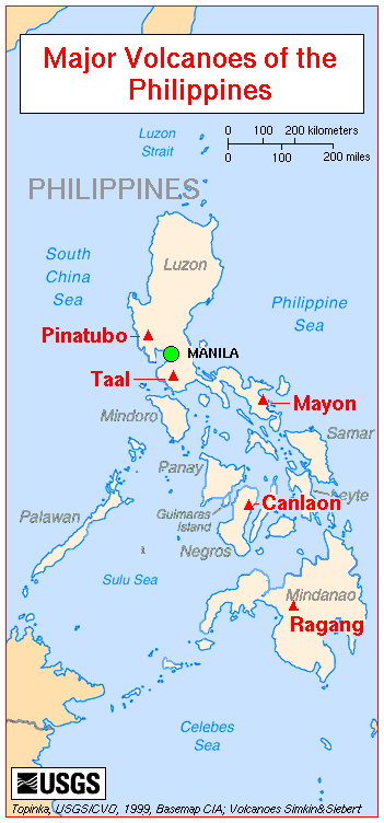
Pacific Ring of Fire
The Pacific Ring of Fire is an area where large numbers of earthquakes and volcanic eruptions occur in the basin of the Pacific Ocean. In a horseshoe shape, it is associated with a nearly continuous series of oceanic trenches, volcanic arcs, and volcanic belts and/or plate movements...
, and are mostly mountainous. The highest point in the country is the peak of Mount Apo
Mount Apo
Mount Apo is a large solfataric, potentially-active stratovolcano in the island of Mindanao, Philippines. With an altitude of , it is the highest mountain in the country and is located between Davao City and Davao del Sur province in Region XI and Cotabato province in Region XII...
in Mindanao
Mindanao
Mindanao is the second largest and easternmost island in the Philippines. It is also the name of one of the three island groups in the country, which consists of the island of Mindanao and smaller surrounding islands. The other two are Luzon and the Visayas. The island of Mindanao is called The...
, which is 2,954 m above sea level. The second highest point can be found on Luzon
Luzon
Luzon is the largest island in the Philippines. It is located in the northernmost region of the archipelago, and is also the name for one of the three primary island groups in the country centered on the Island of Luzon...
at Mount Pulog, a peak 2,842 m above sea level.
The Philippine Archipelago is geologically part of the Philippine Mobile Belt
Philippine Mobile Belt
The Philippine Mobile Belt is a complex portion of the tectonic boundary between the Eurasian Plate and the Philippine Sea Plate, comprising most of the country of the Philippines. It includes two subduction zones, the Manila Trench to the west and the Philippine Trench to the east, as well as the...
located between the Philippine Sea Plate, the South China Sea Basin of the Eurasian Plate
Eurasian Plate
The Eurasian Plate is a tectonic plate which includes most of the continent of Eurasia , with the notable exceptions of the Indian subcontinent, the Arabian subcontinent, and the area east of the Chersky Range in East Siberia...
, and the Sunda Plate
Sunda Plate
The Sunda Plate is the tectonic plate on which the majority of Southeast Asia is located. It was formerly considered a part of the Eurasian Plate, but GPS measurements have confirmed its independent movement at 10 mm/yr eastward relative to Eurasia...
. The Philippine Trench
Philippine Trench
The Philippine Trench is a submarine trench to the east of the Philippines. It has a length of approximately 1,320 km and a width of about 30 km from the centre of the Philippine island of Luzon trending southeast to the northern Maluku island of Halmahera in Indonesia...
(also called the Mindanao Trench) is a 1,320-kilometer-long submarine trench found directly east of the Philippine Mobile Belt and is the result of a collision of tectonic plates. The Philippine Sea Plate is subducting under the Philippine Mobile Belt at the rate of about 16 cm per year. Its deepest point, the Galathea Depth, has a depth of 10,540 meters (5,763 fathoms or 34,580 feet). The Philippine Fault System
Philippine Fault System
The Philippine Fault System is an inter-related system of faults throughout the whole of the Philippine Archipelago, primarily caused by tectonic forces compressing the Philippines into what tectonic geophysicists call the Philippine Mobile Belt....
consists of a series of seismic faults that produce several earthquakes per year, most of which are not felt.
Many volcanoes in the country are active, the most recent eruption being that of Mount Pinatubo
Mount Pinatubo
Mount Pinatubo is an active stratovolcano located on the island of Luzon, near the tripoint of the Philippine provinces of Zambales, Tarlac, and Pampanga. It is located in the Tri-Cabusilan Mountain range separating the west coast of Luzon from the central plains, and is west of the dormant and...
on Luzon in 1991. Mount Mayon is another of the active volcanoes and has the world's most perfectly-shaped cone. Mayon has a violent history of 47 eruptions since 1616 and another violent eruption is currently feared. Taal Volcano
Taal Volcano
Taal Volcano is a complex volcano located on the island of Luzon in the Philippines. Historical eruptions are concentrated on Volcano Island, an island near the middle of Lake Taal. The lake partially fills Taal Caldera, which was formed by powerful prehistoric eruptions between 140,000 to 5,380 BP...
, also located on Luzon, is one of the Decade Volcanoes
Decade Volcanoes
The Decade Volcanoes are 16 volcanoes identified by the International Association of Volcanology and Chemistry of the Earth's Interior as being worthy of particular study in light of their history of large, destructive eruptions and proximity to populated areas...
.
The islands typically have narrow coastal plains and numerous swift-running streams. Every island has sand beaches, but few open onto spacious lowlands. There are few large plains or navigable rivers. The longest river is the Cagayan River
Cagayan River
The Cagayan River is the longest and largest river in the Philippine Archipelago. It is located in the Cagayan Valley region in northeastern part of Luzon island and traverses the provinces of Nueva Vizcaya, Quirino, Isabela and Cagayan.-Topography:...
or Rio Grande de Cagayan in northern Luzon measuring 354 kilometers. In Mindanao, the longest river is the Mindanao River
Mindanao River
The Mindanao River, also known as the Rio Grande de Mindanao, is the second largest river system in the Philippines, after the Cagayan River of Luzon. It is also the largest river on the southern Philippine island of Mindanao having a drainage area of 23,169 square kilometers, draining majority of...
or Rio Grande de Mindanao which drains Maguindanao
Maguindanao
Maguindanao is a province of the Philippines located in the Autonomous Region in Muslim Mindanao . Its capital is Shariff Aguak. It borders Lanao del Sur to the north, Cotabato to the east, and Sultan Kudarat to the south....
and other parts in western-central Mindanao. Agusan River
Agusan River
Agusan River is a river located in the eastern part of Mindanao island in the Philippines, draining majority of the Caraga Region and some parts of Compostela Valley province. It is the third largest river basin of the Philippines with a total drainage area of 10,921 km² and an estimated...
drains eastern Mindanao.
Most of the islands used to be covered by tropical rainforests
Rainforest
Rainforests are forests characterized by high rainfall, with definitions based on a minimum normal annual rainfall of 1750-2000 mm...
. However, illegal logging has reduced forest cover to less than 10% of the total land area.
The Batanes And Babuyan islands
The BatanesBatanes
The Province of Batanes , also called the Batanes Islands, is a Philippine province comprising ten islands that are located in the Luzon Strait between the islands of Luzon and Taiwan...
and Babuyan Islands
Babuyan Islands
The Babuyan Islands form an archipelago located in the Luzon Strait north of Luzon island in the Philippines. It is separated from Luzon by the Babuyan Channel and from the Batanes Islands to its north by the Balintang Channel....
are found on the Luzon Strait north of the Philippines facing Taiwan. It contains the northernmost point of land, the islet of Y'Ami in the Batanes Islands, separated from Taiwan by the Bashi Channel (c.50 mi/80 km wide).
Cagayan Valley
Cagayan Valley (Lambak ng Cagayan in Filipino; Tana' nak Cagayan in the Ibanag languageIbanag language
The Ibanag language is spoken by up to 500,000 speakers in the Philippines, in the northeastern provinces of Isabela and Cagayan, especially in Tuguegarao City, Solana, Cabagan, and Ilagan and with overseas immigrants in countries located in the Middle East, UK and the U.S.A....
; Tanap ti Cagayan in the Ilocano language) is a region of the Philippines, also designated as Region II or Region 02. It is composed of five provinces, namely: Batanes with Basco as the capital, Cagayan, Tuguegarao City as the capital, Isabela considered to be the heart of the region with Ilagan as the capital, Nueva Vizcaya with Bayombong as the capital, and Quirino with Cabaruguis as the capital. It has three cities; Cauayan City in Isabela, its regional center-Tuguegarao in Cagayan, and its commercial center-Santiago City in Isabela.
Most of the region lies in a large valley in northeastern Luzon, between the Cordilleras and the Sierra Madre mountain ranges. The Cagayan River, the country's longest river runs through its center and flows out to Luzon Strait in the north, in the town of Aparri, Cagayan. The Babuyan and Batanes island groups that lie in the Luzon Strait also belong to the region.
Cordilleras and Caraballos
The Cordilleras and Caraballos, together with the Sierra Madre Range, form the main mountain system in Northern Luzon.The Cordilleras consists of 2, sometimes 3, mountain ranges that are found in northwestern central Luzon. The first, called Caraballo del Sur, forms the nucleus of the system and has its highest peaks in the border between the provinces of Abra, Ilocos Norte and Cagayan. The next, called Caraballo Occidentalles, is further divided into 2 ranges, the Cordillera Norte and Cordillera Central. They line the central portions of the Cordillera Administrative Region.
The Caraballos (Caraballo de Baler) start where the Sierra Madre and the Cordilleras meet. They are found south of Cagayan Valley, northeast of the Central Luzon Plains.
Sierra Madre mountains
Sierra Madre Mountain is the longest mountain range in the Philippines that lies in the Northeastern part of Luzon Island. The range stretches from Quezon Province to Isabela. 80 percent of the mountain range is tropical rainforest, which is diminishing from rampant illegal logging activity. Only 5 percent of the mountain range is unexplored. The Sierra Madre Mountain Range serves as the eastern wall of Luzon Island that protects inhibitants from tropical cyclones usually coming from the Pacific Ocean. These storms happen an average of 26 per year will cause a lot of distress for the people living in the biggest island of the Philippines.Central Luzon plains
The largest plain in the country and produces most of the country's rice supply, earning itself the nickname "Rice Bowl of the Philippines". Its provinces are: Aurora, Bataan, Bulacan, Nueva Ecija, Pampanga, Tarlac, and Zambales. It is an administrative division or region of the Republic of the Philippines, primarily serve to organize the 7 provinces of the vast central plain of the island of Luzon (the largest island), for administrative convenienceManila-Calabarzon plains
This region is where the capital of the Philippines is located. Large rivers from bays and mountain springs traverse the plain. In the Northern part of the region, that is, Manila and Rizal, most of the plain has been converted into cities, and are thus industrialized. The plain harbors the largest inland freshwater lake in Southeast Asia, the Laguna de BayLaguna de Bay
Laguna de Bay is the largest lake in the Philippines and the third largest freshwater lake in Southeast Asia after Tonle Sap in Cambodia and Lake Toba in Sumatra, Indonesia. It is on the island of Luzon between the provinces of Laguna to the south and Rizal to the north...
.
Mindoro highlands
The Mindoro mountain range begins with Mount Halcon and is further divided into 3. The northwest ends at Calavite Point and is a landmark for ships. The east originates from Lake Naujan and the west follows Mindoro Strait.
Kalayaan islands (Spratly Islands)
The Kalayaan islands are located to the west of Palawan. "Kalayaan" is a Filipino word meaning "freedom". see Spratly islandsSpratly Islands
The Spratly Islands are a group of more than 750 reefs, islets, atolls, cays and islands in the South China Sea. The archipelago lies off the coasts of the Philippines and Malaysia , about one third of the way from there to southern Vietnam. They comprise less than four square kilometers of land...
Bicol peninsula
This peninsula is connected to mainland Luzon by the isthmus of Tayabas. Provinces occupying Bicol Peninsula are the provinces of Camarines NorteCamarines Norte
Camarines Norte is a province of the Philippines located in the Bicol Region in Luzon. Its capital is Daet and the province borders Quezon to the west and Camarines Sur to the south.-Demographics:...
, Camarines Sur
Camarines Sur
Camarines Sur is a province of the Philippines located in the Bicol Region in Luzon. Its capital is Pili and the province borders Camarines Norte and Quezon to the north, and Albay to the south...
, Albay
Albay
Albay is a province of the Philippines located in the Bicol Region in Luzon. Its capital is Legazpi City and the province borders Camarines Sur to the north and Sorsogon to the south. Also to the northeast is Lagonoy Gulf....
, Sorsogon
Sorsogon
Sorsogon is a province of the Philippines located in the Bicol Region; it is the southernmost province in Luzon and is subdivided into fourteen municipalities and one city. Its capital is Sorsogon City and borders the province of Albay to the north...
and the easternmost municipalities of Quezon Province.
Zamboanga peninsula
Zamboanga Peninsula has a very mountainous terrain this chain of mountain ranges is called the Zamboanga Cordilleras. The highest mountain in this range is Mt. Dapia, which is 2,617 meters (8,586 ft) high.Bukidnon-Lanao plateaus
The plateaus are located in the north-central portion of Mindanao. They are extensive flatlands around the height of 1300 metres (4,265.1 ft) above sea level.Statistics
Unless otherwise indicated, the information below is taken from CIA Factbook information for the Philippines.Area
- Total: 300,000 km2
- Land: 298,170 km2
- Water: 1,830 km2
Maritime claims
(measured from claimed archipelagic baselines)- Continental shelf: to depth of exploitation
- Exclusive economic zone: 200 nautical miles (370.4 km)
Territorial sea: irregular polygon extending up to 100 nautical miles (185 km) from coastline as defined by 1898 treaty; since late 1970s has also claimed polygonal-shaped area in South China Sea up to 285 nautical miles (528 km) in breadth.
Natural hazards
The Philippines sit astride typhoon belt and are usually affected by 15 and struck by five to six cyclonic storms per year; landslides; active volcanoes; destructive earthquakes; tsunamiTsunami
A tsunami is a series of water waves caused by the displacement of a large volume of a body of water, typically an ocean or a large lake...
s.
Environment - current issues
- Uncontrolled deforestation in watershed areas; soil erosion; air and water pollution in Manila; increasing pollution of coastal mangrove swamps which are important fish breeding grounds; severe water pollution that caused the death of one of the country's major rivers, though there are ongoing efforts at resuscitation.
Environment - international agreements
- Party to: Biodiversity, Climate Change, Endangered Species, Hazardous Wastes, Law of the Sea, Marine Dumping, Nuclear Test Ban, Ozone Layer Protection, Tropical Timber 83, Tropical Timber 94, Wetlands, Whaling
- Signed, but not ratified: Climate Change-Kyoto Protocol, Desertification
Ten largest cities
The following is a list of the ten largest cities in the country in terms of population, with their population according to the 2007 census. Component cities and municipalities of Metro Manila and Metro Cebu are taken as one to show the extent of urbanizationUrbanization
Urbanization, urbanisation or urban drift is the physical growth of urban areas as a result of global change. The United Nations projected that half of the world's population would live in urban areas at the end of 2008....
.
| Rank | City | Population in 2007 |
|---|---|---|
| 1. | Metro Manila Metro Manila Metropolitan Manila , the National Capital Region , or simply Metro Manila, is the metropolitan region encompassing the City of Manila and its surrounding areas in the Philippines... |
11,553,427 |
| 2. | Metro Cebu Metro Cebu Metro Cebu is the main urban center of the province of Cebu in the Philippines. Metro Cebu is located along the central eastern portion of the island including the nearby island of Mactan... |
2,314,897 |
| 3. | Metro Davao Metro Davao Metro Davao is an agglomeration of Davao City and four surrounding cities: Digos City in Davao del Sur, Tagum City, Panabo City and the Island Garden City of Samal in Davao del Norte... |
1,363,337 |
| 4. | Zamboanga City Zamboanga City The City of Zamboanga : is a highly urbanized, independent and a chartered city located in Mindanao, Philippines.... |
774,407 |
| 5. | Antipolo City Antipolo City Antipolo is a city in the Philippines located in the province of Rizal; about 25 kilometers east of Manila. It is the largest city in the Calabarzon Region in terms of population... |
633,971 |
| 6. | Cagayan de Oro City Cagayan de Oro City Cagayan de Oro; , officially the City of Cagayan de Oro, is the provincial capital city of the province of Misamis Oriental in the Philippines... |
553,966 |
| 7. | General Santos City General Santos City The City of General Santos is the southernmost port city of the Philippines. Being a highly urbanized first class city, GenSan is one of the most populous urban centers in the country with a population of 679,588 as per census data of 2010... |
529,542 |
| 8. | Bacolod City Bacolod City The City of Bacolod , is a highly urbanized midsize Philippine city. It is the capital of the Negros Occidental province. Having a total of 499,497 inhabitants as of August 1, 2007, it is the most populous city in the Western Visayas Region. It is currently ranked as the 17th most populous city in... |
499,497 |
| 9. | Iloilo City Iloilo City The City of Iloilo is a highly urbanized city in the Philippines and the capital city of Iloilo province. It is the regional center of the Western Visayas, as well as the center of the Iloilo-Guimaras Metropolitan Area... |
418,710 |
| 10. | Calamba City Calamba City Calamba City is a first class component city located in the province of Laguna, Philippines. Situated only 54 kilometers south of Manila, about an hour by chartered bus, Calamba City is a popular tourist destination with its hot spring resorts, most of the resorts are located in Barangay Pansol... |
360,281 |