
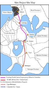
South Luzon Expressway
Overview
Metro Manila
Metropolitan Manila , the National Capital Region , or simply Metro Manila, is the metropolitan region encompassing the City of Manila and its surrounding areas in the Philippines...
to the provinces of the CALABARZON
CALABARZON
CALABARZON is one of the regions of the Philippines. It is also designated as Region IV-A and its regional center is Calamba City in Laguna...
region in the Philippines
Philippines
The Philippines , officially known as the Republic of the Philippines , is a country in Southeast Asia in the western Pacific Ocean. To its north across the Luzon Strait lies Taiwan. West across the South China Sea sits Vietnam...
. The first expressway is the Metro Manila Skyway System
Metro Manila Skyway
The Metro Manila Skyway is an elevated highway crossing over much of the existing South Luzon Expressway as of the moment. It is located within the Metro Manila portion of the SLEX and crosses through Makati City, Pasay City, Parañaque City, and Muntinlupa City. The Skyway begins in Barangay San...
, operated jointly by the Skyway Operation and Management Corporation (SomCo) and Citra Metro Manila Tollways Corporation (CMMTC).