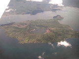
Taal Volcano is a
complex volcanoA complex volcano, also called a compound volcano, is a volcano with more than one feature. They form because changes of their eruptive characteristics or the location of multiple vents in an area...
located on the island of
LuzonLuzon is the largest island in the Philippines. It is located in the northernmost region of the archipelago, and is also the name for one of the three primary island groups in the country centered on the Island of Luzon...
in the
PhilippinesThe Philippines , officially known as the Republic of the Philippines , is a country in Southeast Asia in the western Pacific Ocean. To its north across the Luzon Strait lies Taiwan. West across the South China Sea sits Vietnam...
. Historical eruptions are concentrated on Volcano Island, an island near the middle of Lake Taal. The lake partially fills Taal Caldera, which was formed by powerful prehistoric eruptions between 140,000 to 5,380 BP. Viewed from
TagaytayThe City of Tagaytay is a second class city in the province of Cavite, Philippines. Only away from Manila via Aguinaldo Highway, it is one of the country's most popular tourist destinations. Tagaytay City provides a good view of the Taal Volcano...
Ridge, Taal Volcano and Lake presents one of the most picturesque and attractive views in the Philippines. It is located about 50 km (31.1 mi) south of the capital of the country, the city of
ManilaManila is the capital of the Philippines. It is one of the sixteen cities forming Metro Manila.Manila is located on the eastern shores of Manila Bay and is bordered by Navotas and Caloocan to the north, Quezon City to the northeast, San Juan and Mandaluyong to the east, Makati on the southeast,...
.
The volcano had several violent eruptions in the past causing loss of life in the island and the populated areas surrounding the lake, with the death toll estimated at around 5,000 to 6,000. Because of its proximity to populated areas and its eruptive history, the volcano was designated a
Decade VolcanoThe Decade Volcanoes are 16 volcanoes identified by the International Association of Volcanology and Chemistry of the Earth's Interior as being worthy of particular study in light of their history of large, destructive eruptions and proximity to populated areas...
, worthy of close study to prevent future
natural disasterA natural disaster is the effect of a natural hazard . It leads to financial, environmental or human losses...
s. It is one of the
active volcanoes in the PhilippinesActive is commonly termed for volcanoes with historical eruptions. Moreover, the Philippine Institute of Volcanology and Seismology classify active volcanoes in the country as having erupted within historical times , with accounts of these eruptions documented by man; or having erupted within the...
and part of the
Pacific ring of fireThe Pacific Ring of Fire is an area where large numbers of earthquakes and volcanic eruptions occur in the basin of the Pacific Ocean. In a horseshoe shape, it is associated with a nearly continuous series of oceanic trenches, volcanic arcs, and volcanic belts and/or plate movements...
.
Geography
Taal Volcano and Lake are wholly located in the
provinceThe Provinces of the Philippines are the primary political and administrative divisions of the Philippines. There are 80 provinces at present, further subdivided into component cities and municipalities. The National Capital Region, as well as independent cities, are autonomous from any provincial...
of
BatangasBatangas is a first class province of the Philippines located on the southwestern part of Luzon in the CALABARZON region. Its capital is Batangas City and it is bordered by the provinces of Cavite and Laguna to the north and Quezon to the east. Across the Verde Island Passages to the south is the...
. The northern half of Volcano Island falls under the jurisdiction of the lake shore town of
Talisay, and the southern half to
San NicolasSan Nicolas is a 5th class municipality in the province of Batangas, Philippines. According to the latest census, it has a population of 19,046 people in 2,946 households...
. The other towns that encircle Taal Lake include
TanauanThe City of Tanauan is a second class city in the province of Batangas, Philippines. According to the latest census, it has a population of 142,537 inhabitants in 21,912 households. It was incorporated as a city under Republic Act No...
,
Talisay,
LaurelLaurel is a fourth class municipality in the Province of Batangas, Philippines. According to the latest census, it has a population of 34,953 people in 5,153 households...
,
AgoncilloAgoncillo is a 3rd class municipality in the Province of Batangas, Philippines. According to the latest census, it has a population of 33,990 people in 5,029 households....
,
Santa TeresitaSanta Teresita is a 4th class municipality in the province of Batangas, Philippines. According to the latest census, it has a population of 16,891 people in 2,762 households....
, Alitagtag,
CuencaCuenca is a 4th class municipality in the province of Batangas, Philippines. According to the latest census, it has a population of 28,581 people in 5,222 households....
,
LipaThe Lipa City /Li-pâ/ is a first class city in the province of Batangas, Philippines. It is one of the three component cities of Batangas province...
,
BaleteBalete is a 5th class municipality in the Province of Batangas, Philippines. According to the latest census, it has a population of 19,252 people in 3,067 households.Balete is well known for its location, because of the panoramic view of the Taal Volcano....
and
Mataas na KahoyMataasnakahoy is a 4th class municipality in the Province of Batangas, Philippines. According to the latest census, it has 25,400 people in 3,918 households....
.
Permanent settlement in the island is prohibited by the
Philippine Institute of Volcanology and SeismologyThe Philippine Institute of Volcanology and Seismology is a Philippine national institution dedicated to provide information on the activities of volcanoes, earthquakes and tsunamis, as well as other specialized information and services primarily for the protection of life and property and in...
or PHIVOLCS, declaring the whole Volcano Island as a high-risk area and a Permanent Danger Zone (PDZ). Despite the warnings, poor families have settled on the island, risking their lives, earning a living by fishing and farming crops from the rich volcanic soil.
Recent activity
Although the volcano has been quiet since 1977, it has shown signs of unrest since 1991, with strong seismic activity and ground fracturing events, as well as the formation of small mud pots and mud
geyserA geyser is a spring characterized by intermittent discharge of water ejected turbulently and accompanied by a vapour phase . The word geyser comes from Geysir, the name of an erupting spring at Haukadalur, Iceland; that name, in turn, comes from the Icelandic verb geysa, "to gush", the verb...
s on parts of the island. The
Philippine Institute of Volcanology and SeismologyThe Philippine Institute of Volcanology and Seismology is a Philippine national institution dedicated to provide information on the activities of volcanoes, earthquakes and tsunamis, as well as other specialized information and services primarily for the protection of life and property and in...
(PHIVOLCS) regularly issues notices and warnings about current activity at Taal, including ongoing seismic unrest.
2011
- 5 Jul. Alert Level was lowered from 2 to 1 after 11 weeks (April 9) of increased activity.
- 1 Jun. Alert Level 2. Volcanic earthquakes (24 hrs) = 22. (2) Intensity II earthquakes in the eastern sector of volcano accompanied by rumbling sounds. Bubbling activity observed in the middle of Main Crater Lake.
- 31 May. Alert Level 2. Volcanic earthquakes (24 hrs) = 31. (1) Intensity I and (2) Intensity II earthquakes, NE & SE sector of volcano accompanied by rumbling sounds.
- 30 May. Alert Level 2. Volcanic earthquakes (24 hrs) = 115. (1) Intensity I, (9) Intensity II, (1) Intensity III, and (1) Internsity IV earthquakes, NE, SW & SE sector of volcano accompanied by rumbling sounds.
- 29 May. Alert Level 2. Volcanic earthquakes (24 hrs) = 10.
- 28 May. Alert Level 2. Volcanic earthquakes (24 hrs) = 6. Magma has been intruding towards the surface, as indicated by continuing high rates of CO2 emissions in the Main Crater Lake and sustained seismic activity. Field measurements on 24 May 2011 show lake temperatures slightly increased, pH values slightly more acidic and water levels 4 cm higher. A ground deformation survey conducted around the Volcano Island 26 April - 3 May 2011 showed that the volcano edifice inflated slightly relative to the 05-11 April 2011 survey.
- 22 May. Alert level 2. Volcanic earthquakes (25 hrs) = 5.
- 10 Apr. Alert Level 2. The main crater, Daang Kastila Trail, and Mt Tabaro are strictly off-limits to the public because sudden hazardous steam-driven explosions could occur. Breathing air with high concentration of gases can be lethal to humans, animals and can even damage vegetation, the agency warned
2010
- 8 June. PHIVOLCS raised the volcano status to Alert Level 2 (scale is 0-5, 0 referring to No Alert status), which indicates the volcano is undergoing magmatic intrusion which could eventually lead to an eruption. PHIVOLCS reminds the general public that the Main Crater remains off-limits because hazardous steam-driven explosions may occur, along with the possible build-up of toxic gases. Areas with hot ground and steam emission such as portions of the Daang Kastila Trail are considered hazardous.
- 11–24 May. Crater lake temperature increased by 2-3°C. The composition of Main Crater Lake water has shown above normal values of Mg/Cl, SO4/Cl and Total Dissolved Solids. There has been ground steaming accompanied by hissing sounds on the northern and northeast sides of the main crater.
- 26 April. Volcanic seismicity had increased.
2009
- 20 July. National Disaster Coordinating Council (NDCC) executive officer Glenn Rabonza warned that although there were no volcanic quakes detected at Taal since the detection of nine volcanic quakes from June 13 to July 19, and there had been no steaming activity monitored since last recorded on June 23, Phivolcs Alert stands at Level 1, warning that Taal’s main crater is off-limits to the public because steam explosions may suddenly occur or high concentrations of toxic gases may accumulate.
2008
- 28 August. PHIVOLCS notified the public and concerned authorities that the Taal seismic network recorded ten (10) volcanic earthquakes from 5:30 AM to 3 PM. Two (2) of these quakes that occurred at 12:33 and 12:46 PM, were both felt at intensity II by residents at barangay Pira-piraso. These quakes were accompanied by rumbling sounds. The events were located northeast of the volcano island near Daang Kastila area with depths of approximately 0.6 km (12:33 PM) and 0.8 km (12:46 PM)"
Geological history
Taal Volcano is part of a chain of
volcano2. Bedrock3. Conduit 4. Base5. Sill6. Dike7. Layers of ash emitted by the volcano8. Flank| 9. Layers of lava emitted by the volcano10. Throat11. Parasitic cone12. Lava flow13. Vent14. Crater15...
es along the western side of the edge of the island of Luzon, which were formed by the
subductionIn geology, subduction is the process that takes place at convergent boundaries by which one tectonic plate moves under another tectonic plate, sinking into the Earth's mantle, as the plates converge. These 3D regions of mantle downwellings are known as "Subduction Zones"...
of the
Eurasian PlateThe Eurasian Plate is a tectonic plate which includes most of the continent of Eurasia , with the notable exceptions of the Indian subcontinent, the Arabian subcontinent, and the area east of the Chersky Range in East Siberia...
underneath the
Philippine Mobile BeltThe Philippine Mobile Belt is a complex portion of the tectonic boundary between the Eurasian Plate and the Philippine Sea Plate, comprising most of the country of the Philippines. It includes two subduction zones, the Manila Trench to the west and the Philippine Trench to the east, as well as the...
. Taal Lake lies within a 25–30 km caldera formed by four explosive eruptions between 500,000 and 100,000 years ago. Each of these eruptions created extensive
ignimbriteAn ignimbrite is the deposit of a pyroclastic density current, or pyroclastic flow, a hot suspension of particles and gases that flows rapidly from a volcano, driven by a greater density than the surrounding atmosphere....
deposits, reaching as far away as where
ManilaManila is the capital of the Philippines. It is one of the sixteen cities forming Metro Manila.Manila is located on the eastern shores of Manila Bay and is bordered by Navotas and Caloocan to the north, Quezon City to the northeast, San Juan and Mandaluyong to the east, Makati on the southeast,...
stands today.
Since the formation of the caldera, subsequent eruptions have created another volcanic island, within the caldera, known as Volcano Island. This island covers an area of about 23 square kilometres (8.9 sq mi), and consists of overlapping cones and craters. Forty-seven different cones and craters have been identified on the island.
Eruption history
There have been 33 recorded eruptions at Taal since 1572. The first eruption of which there is any record occurred in 1572, the year the Agustinian friars founded the town of
TaalTaal is a 4th class municipality in the province of Batangas, Philippines. According to the latest census, it has a population of 51,459 people in 8,451 households.It is the Balisong and Barong Tagalog Capital of the Philippines...
on the shores of the lake (on what is now
San Nicolas, BatangasSan Nicolas is a 5th class municipality in the province of Batangas, Philippines. According to the latest census, it has a population of 19,046 people in 2,946 households...
). In 1591, another mild eruption took place featured by great masses of smoke issuing forth from the crater. From 1605 to 1611, the volcano displayed such great activity that Father Torna de Abreu had a huge cross of
anubing wood erected on the brink of the crater.
Between 1707 and 1731, the center of activity shifted from the Main Crater to other parts of Volcano Island. The eruptions of 1707 and 1715 occurred in Binitiang Malaki crater (the cinder cone visible from Tagaytay). Minor eruptions also emanated from the Binintiang Munti crater on the westernmost tip of the island in 1709 and 1729. A more violent activity happened on September 24, 1716, when the whole southeastern portion of the crater (Calauit), opposite Mount Macolod, was blown out. The 1731 eruption off Pira-Piraso or eastern tip of the island created an island. No studies had been done to determine whether Napayon or Bubuin Island was formed in the eruption, or just a
pumice raftA pumice raft is a floating raft of pumice occasionally created by ocean-based volcanic activity.Volcanic activity in the South Pacific near Tonga on August 12, 2006 caused the emergence of a new island...
.
Activity returned to the Main Crater in 1749, and it was remembered for being particularly violent (
VEIThe Volcanic Explosivity Index was devised by Chris Newhall of the U.S. Geological Survey and Stephen Self at the University of Hawaii in 1982 to provide a relative measure of the explosiveness of volcanic eruptions....
= 4). Then came the great 200-day eruption of 1754, the greatest eruption of Taal which is described below.
Taal remained quiet for 54 years except for a minor eruption in 1790, not until March 1808 did another big eruption occur. While this outbreak was not as violent as the one in 1754, the immediate vicinity were covered with ashes to a depth of 84 centimetres (33.1 in). It brought great changes in the interior of the crater, according to chroniclers of that time. Before, the bottom looked very deep and seemed unfathomable, but at the bottom, a liquid mass was seen in continual ebullition. After the eruption, the crater had widened and the pond within it had been reduced to one-third and the rest of the crater floor was higher and dry enough to walk over it. The height of the crater walls has diminished and near the center of the new crater floor, a little hill that continually emitted smoke. On its sides were several wells, one of which was especially remarkable for its size.
On July 19, 1874, an eruption of gases and ashes killed all the live stock on the island. From November 12 to 15, 1878, ashes ejected by the volcano covered the entire island. Another eruption took place in 1904 as a result of which a new outlet was formed in the southeastern wall of the principal crater. The last eruption from the Main Crater was in 1911 which obliterated the crater floor creating the present lake. In 1965, a huge explosion sliced off a huge part of the island, moving activity to a new eruption center, Mount Tabaro. Eruptions have also been recorded in 1634, 1635, 1641, 1645, 1790, 1825, 1842, 1873, 1885, 1903, 1966, 1967, 1968, 1969, 1970, 1976 and 1977. Some of the major eruptions are described below:
The 1754 eruption
Taal Volcano's greatest recorded eruption occurred in 1754 which lasted from May 15 to December 1. The following is the narrative account of Fr. Buencuchillo, parish priest of Sala, and stationed at Taal at that time:
-
- On May 15, 1754, at about 9 or 10 o'clock in the night, the volcano quite unexpectedly commenced to roar and emit, sky-high, burning flames intermixed with glowing rocks which, falling back upon the island and rolling down the slopes of the mountain, created the impression of a large river of fire. During the following days there appeared in the lake a large quantity of pumice stone which had been ejected by the volcano. Part of these eject had also reached the hamlet of Bayuyungan and completely destroyed it.
-
- The volcano continued thus until June 2, during the night of which the eruption reached such proportions that the falling ejecta made the entire island appear to be on fire, and it was even feared that the catastrophe might involve the shores of the lake. From the said 2nd of June until September 25, the volcano never ceased to eject fire and mud of such bad character that the best ink does not cause so black a stain.
-
- During the night of September 25, the fire emitted was quite extraordinary and accompanied by terrifying rumblings. The strangest thing was, that within the black column of smoke issuing from the volcano ever since June 2, there frequently formed thunderstorms, and it happened that the huge tempest cloud would scarcely ever disappear during two months.
-
- At daybreak of September 26 we found ourselves forced to abandon our dwelling for fear lest the roofs come down upon us under the weight of ashes and stones which had fallen upon them during that hapless night. In fact, some weaker buildings collapsed. The depth of the layer of ashes and stones exceeded two "cuartas" (45 centimeters), and the result was that there was neither tree nor other plant which it did not ruin or crush, giving to the whole region an aspect as if a devastating conflagration had swept over it. After this the volcano calmed down considerably, though not sufficiently to offer any prospect of tranquility.
-
- During the night of November 1, Taal resumed its former fury, ejecting fire, rocks, sand, and mud in greater quantities than ever before. On November 15, it vomited enormous boulders which rolling down the slopes of the island, fell into the lake and caused huge waves [note(added by Saderra Maso): The waves mentioned were most probably due to the earthquake rather than to the falling rocks]. The paroxysms were accompanied by swaying motions of the ground which caused all the houses of the town to totter. We had already abandoned our habitation and were living in a tower which appeared to offer greater security; but on this occasion we resolved that the entire population retire to the Sanctuary of Casaysay, only the "Administrator" and myself to remain on the spot.
-
- At 7 in the evening of November 28 occurred a new paroxysm, during which the volcano vomited forth such masses of fire and ejecta that in my opinion, all the material ejected during so many months, if taken together, would not equal the quantity which issued at the time. The columns of fire and smoke ascended higher than ever before, increasing every moment in volume, and setting fire to the whole island, there being not the smallest portion of the latter which was not covered by the smoke and the glowing rocks and ashes. All this was accompanied by terrific lightning and thunder above, and violent shocks of earthquakes underneath. The cloud of ejecta, carried on by the wind, extended itself toward west and south with the result that we saw already some stones fall close to our shore. I, therefore, shouted to all those who were still in the town to take to flight and we all ran off in a hurry; otherwise we would have been engulfed on the spot; as the waves of the angry lake began already to flood the houses nearest to the beach.
-
- We left the town, fleeing this living picture of Sodom, with incessant fear lest the raging waters of the lake overtake us, which were at the moment invading the main part of the town, sweeping away everything they encountered. On the outskirts of the town, I came upon a woman who was so exhausted by her burden of two little children and a bundle of clothing that she could proceed no farther. Moved by pity, I took one of the toddlers from her and carried him, and the little indio who has been wailing while in the arms of his mother, stopped short when I took him into mine and never uttered a sound while I was carrying him a good piece of the way.
-
- Having reached a secure place on elevated ground at a distance of about half a league (2 kilometers) from the town, we halted in a hut to rest a little and take some food. From this spot the volcano could be contemplated with a little more serenity of mind. It still continued in full fury, ejecting immense masses of material. Now I also observed that the earth was in continuous, swaying motion, a fact which I had failed to notice during the excitement and fear of the flight.
-
- Shortly afterward the volcano suddenly subsided almost suddenly; its top was clear and apparently calm. We, therefore, returned on the following day, the 29th, to the town with the intention of surveying the havoc wrought during the preceding night.
-
- The 29th had dawned calm, but while we were still trying to persuade ourselves that the tragedy was over and the volcano had exhausted its bowels, at about 8 o'clock, we heard a crash and then I noticed that smoke was rising from the point of the island that looks towards east. The smoke spread very gradually as far as the crater of the volcano, while there were many whiffs issuing from points in the direction of another headland. I realized that the island had opened in these places and fearing that, if a crater should open below the water, an explosion might follow, much more formidable than the preceding ones, I mounted a horse and retired permanently to the Sanctuary of Caysasay.
-
- Between 3 and 4 o'clock in the afternoon of the said 29th, it began to rain mud and ashes at Caysasay [12 miles from the volcano] and this rain lasted three days. The most terrifying circumstance was that the whole sky was shrouded in such darkness that we could not have seen the hand placed before the face, had it not been for the sinister glare of incessant lightnings. Nor could we use artificial light as this was extinguished by the wind and copious ashes which penetrated everywhere. All was horror those three days, which appeared rather like murky nights and we did not occupy ourselves with anything but see to it that the natives swept off the roofs the large quantities of ashes and stones which kept on accumulating upon them and threatened to bring them down upon us, burying us alive beneath their weight. But fearing that even these precautions might prove unavailing, we 3 Europeans - viz. Fr. Prior, the Alcalde, and myself - the only ones who were at the time in the Convento of Caysasay, took refuge on the landing of the stairs; as the safest place, and awaited there whatever God might dispose with regard to us. To all this was added incessant thunder and lightning, and it really looked as if the world was going to pieces and its axis had been displaced.
-
- During the night of the 30th we had not a moment of repose, as every moment we heard the loud crush of houses collapsing under of stones, mud, and ashes piled upon them, and feared that the turn of the convento and the church of Casasay would come in next. Shortly before daybreak of December 1 there was a tremendous crash as if the house were coming down on our heads: the roof of the apse of the church had caved in! Not long afterward, the roof of their kitchen gave away with a thud. Both were tile roofs.
-
- The first of December broke somewhat clear and our eyes contemplated everywhere ruins and destruction. The layer of ashes and mud was more than 5 spans [1.10 m] thick, and it was almost a miracle that the roof of the church and convento sustained so great a weight. We caused the bulk of the material to be removed, while new continued to fall on that day and the following, on which latter the direction of the wind changed, carrying the ejecta toward Balayan. On the 3rd and 4th we had a formidable typhoon, and thereafter the volcano quieted down.
-
- Soon afterward I resolved to visit my town of Taal; nothing was left of it except the walls of the church and convento. All the rest, the government house, the walks of the rope factory, the warehouse, everything was buried beneath a layer of stones, mud, and ashes more than 10 spans [2.20 m] thick; only here and there could be seen an upright post, the only remnant of a comfortable dwelling. I went down to the river and found it completely filled up, with a boat belonging to the alcalde and many of private persons buried in the mud. After incredible efforts I finally succeeded in unearthing in what had once been the church and sacristy, the chests which contained the sacred vestments and vessels. Nearly all of them were demolished by the rocks and beams which had fallen upon them, and filled with foul-smelling mud that had ruined or disfigured their contents. With the aid of some natives of Bauang, I likewise recovered some property from among the ruins of the convento.
-
- Twelve persons are known to have perished - some carried away by the waves of the lake, others crushed beneath their collapsing houses. Thus the beautiful town of Taal remains a deserted wilderness and reduced to the utmost misery, while once it was one of the richest and most flourishing places. In the villages to the west of the lake, which were the greater and better part, all the houses have either collapsed under the load of material which had been piled upon them or have disappeared completely, swept away by the waves which in these places were so violent that they dug three ditches or channels, too wide and deep to be forded, and thus rendered impassable the road which joins the town with Balayan. In other parts of the lake shore have likewise opened many cracks and occurred very extensive slides. The worst of all is, that, the mouth of the river Pansipit having been blocked, the lake is rising and invading the towns of Lipa and Tanauan, both being on the lowest level, and inundating their buildings. All the animals of whatever kind have perished, some by being buried, others by drowning, the rest by starving, as not a green blade remained anywhere.
-
- The same fate as Taal has befallen the towns of Lipa, Tanauan, and so much of Sala as still existed. These towns, together with Taal, lay around the lake, being situated within easy reach of it, and less than one league [4 kilometers] from the volcano. The bulk of the population left this neighborhood and settled in more distant places. Thus out of 1200 taxpayers whom Taal contained formerly, hardly 150 remain in the poorest and least respectable villages, which suffered little from the rain of ashes.
1911 eruption
One of the more devastating eruptions occurred in January, 1911. During the night of the 27th of that month, the seismographs at the Manila Observatory commenced to register frequent disturbances, which were at first of insignificant importance, but increased rapidly in frequency and intensity. The total recorded shocks on that day numbered 26. During the 28th there were recorded 217 distinct shocks, of which 135 were microseismic, while 10 were quite severe. The frequent and increasingly strong earthquakes caused much alarm at Manila, but the observatory staff was soon able to locate their epicenter in the region of Taal Volcano and assured the public that Manila was in no danger, as Taal is distant from it some 37 miles (59.5 km).
In Manila in the early hours of January 30, 1911, people were awakened out of their sleep by what they at first took for loud thunder. The illusion was heightened when great streaks of lightning were seen to illumine the southern sky. Those who investigated further, however, soon learned the truth. A huge, fan-shaped cloud of what looked like black smoke rose to a great height. It was crossed and crisscrossed with a brilliant electrical display, which the people of Manila at first took for lightning. This cloud finally shot up in the air, spread, then dissipated, and this marked the culmination of the eruption, at about 2:30 a. m.
On Volcano island, the destruction was complete. It seems that when the black, fan-shaped cloud spread, it created a blast downward that forced hot steam and gases down the slopes of the crater, accompanied by a shower of hot mud and sand. Many trees had the bark shredded and cut away from the surface by the hot sand and mud blast that accompanied the explosion and contributed so much to the loss of life and destruction of property. The fact that practically all the vegetation was bent downward, away from the crater, proved that there must have been a very strong blast down the outside slopes of the cone. Very little vegetation was actually burned or even scorched. Six hours after the explosion, dust from the crater was noticeable in Manila as it settled on furniture and other polished surfaces. The solid matter ejected had a volume of between 70,000,000 and 80,000,000 cubic meters (
VEIThe Volcanic Explosivity Index was devised by Chris Newhall of the U.S. Geological Survey and Stephen Self at the University of Hawaii in 1982 to provide a relative measure of the explosiveness of volcanic eruptions....
= 3). Ashes fell over an area of 2000 square kilometre, although the area in which actual destruction took place measured only 230 square kilometre. The detonation from the explosion was heard over an area more than 600 miles (965.6 km) in diameter.
Death toll
The eruption claimed a reported 1,335 lives and injured 199; although it is known that more perished than the official records show. The seven
barangayA barangay is the smallest administrative division in the Philippines and is the native Filipino term for a village, district or ward...
s that existed on the island previous to the eruption were completely wiped out. Post mortem examination of the victims seemed to show that practically all had died of scalding by hot steam or hot mud, or both. The devastating effects of the blast reached the west shore of the lake where a number of villages were also destroyed. Cattle to the number of 702 were killed and 543 nipa houses destroyed. Crops suffered from the deposit of ashes that fell to a depth of almost half an inch in places near the shore of the lake.
Observations on the Volcano Island after the eruption
Volcano Island sank from three to ten feet as a result of the eruption. It was also found that the southern shore of Lake Taal sank in elevation from the eruption. No evidences of lava could be discovered anywhere, nor have geologists been able to trace any visible records of a lava flow having occurred at any time on the volcano back then. Another peculiarity of the geologic aspects of Taal is the fact that no sulphur has been found on the volcano. The yellow deposits and encrustations noticeable in the crater and its vicinity are iron salts, according to chemical analysis. Slight smell of sulfur was perceptible at the volcano, which came from the gases that escape from the crater.
Changes on the crater after the eruption
Great changes took place in the crater after the eruption. Before 1911, the crater floor was higher than Taal lake and had several separate openings in which were lakes of different colors. There was a green lake, a yellow lake, a red lake and some holes filled with hot water from which steam issued. Many places were covered with a shaky crust of volcanic material, full of crevices, which was always hot and on which it was rather dangerous to walk. Immediately after the explosion, the vari-colored lakes had disappeared and in their place was one large lake, about ten feet below the level of the lake surrounding the island. The crater lake gradually rose until it is on a level with the water in Taal Lake. Opinions after the creation of the lake that the presence of the water in the crater has a tendency to cool off the material below and thus lessen the chances of an explosion or make the volcano extinct, but the preponderance of expert opinion was otherwise.(The subsequent eruption in 1965 and succeeding activities came from a new eruptive center, Mount Tabaro.)
Ten years after the eruption, no changes in the general outline of the island could be discerned at a distance. On the island, however, many changes were noted. The vegetation had increased; great stretches that were formerly barren and covered with white ashes and cinders became covered with vegetation.
Vulcan Point
One large rock, now called Vulcan Point that projects from the surface of the crater lake was the remnant of the old crater floor that is now surrounded by the 2 kilometres (1.2 mi) wide lake, now referred to as the Main Crater Lake. Vulcan Point is cited as the world's largest island within a lake on an island within a lake on an island, i.e., Vulcan Point within Crater Lake, on Taal Island within Lake Taal, on the island of Luzon.
1965 to 1977 eruption
The most recent period of activity lasted from 1965 to 1977 with the area of activity concentrated in the vicinity of Mount Tabaro. The 1965 eruption was classified as phreatomagmatic, generated by the interaction of magma with the lake water that produced the violent explosion that cut an embayment on Volcano Island. The eruption generated "cold" base surges which traveled several kilometers across Lake Taal, devastating villages on the lake shore and, killing about a hundred people. That eruption, in particular, led to the recognition of base surge (one of the American geologists who witnessed an atomic bomb explosion as a soldier and visited the volcano shortly after the 1965 eruption, compared it to an atomic base surge) as a process in volcanic eruption, which are now called
pyroclastic surgeA pyroclastic surge is a fluidized mass of turbulent gas and rock fragments which is ejected during some volcanic eruptions. It is similar to a pyroclastic flow but it has a lower density or contains a much higher proportion of gas to rock ratio, which makes it more turbulent and allows it to rise...
s when relating to volcanoes. The population of the island was evacuated only after the onset of the eruption. Precursory signs were not interpreted correctly until after the eruption.
The
strombolian eruptionStrombolian eruptions are relatively low-level volcanic eruptions, named after the Italian volcano Stromboli, where such eruptions consist of ejection of incandescent cinder, lapilli and lava bombs to altitudes of tens to hundreds of meters...
s of 1968 and 1969 produced massive lava flow that eventually covered the bay created by the 1965 eruption, reaching the shore of Lake Taal. The last major activities on the volcano were the
phreatic eruptionA phreatic eruption, also called a phreatic explosion or ultravulcanian eruption, occurs when rising magma makes contact with ground or surface water. The extreme temperature of the magma causes near-instantaneous evaporation to steam, resulting in an explosion of steam, water, ash, rock, and...
s of 1976 and 1977.
Eruption precursors at Taal
- Increase in frequency of volcanic quakes with occasional felt events accompanied by rumbling sounds
- On the Main Crater Lake, changes in the water temperature, level, and bubbling or boiling activity on the lake.
Before the 1965 eruption began, the lake's temperature rose to several degrees above normal. However, on some eruptions there is no reported increase in the lake's temperature. On some eruptions, the dissolution of acidic volcanic gases into the lake has resulted in the death of large numbers of fish and animals.
- Development of new or reactivation of old thermal areas like fumarole
A fumarole is an opening in a planet's crust, often in the neighborhood of volcanoes, which emits steam and gases such as carbon dioxide, sulfur dioxide, hydrochloric acid, and hydrogen sulfide. The steam is created when superheated water turns to steam as its pressure drops when it emerges from...
s, geyserA geyser is a spring characterized by intermittent discharge of water ejected turbulently and accompanied by a vapour phase . The word geyser comes from Geysir, the name of an erupting spring at Haukadalur, Iceland; that name, in turn, comes from the Icelandic verb geysa, "to gush", the verb...
s or mudpotA mudpot, mud pool or paint pot is a sort of hot spring or fumarole consisting of a pool of usually bubbling mud. The mud is generally of white to greyish color, but is sometimes stained with reddish or pink spots from iron compounds...
s
- Ground inflation or ground fissuring.
- Increase in temperature of ground probe holes on monitoring stations.
- Strong sulfuric odor or irritating fumes similar to rotten eggs.
- Fish kills and drying up of vegetation
Other possible precursors
Volcanologists measuring the concentration of
radonRadon is a chemical element with symbol Rn and atomic number 86. It is a radioactive, colorless, odorless, tasteless noble gas, occurring naturally as the decay product of uranium or thorium. Its most stable isotope, 222Rn, has a half-life of 3.8 days...
gas in the soil on Volcano island measured an anomalous increase of the radon concentration by a factor of six in October 1994. This increase was followed 22 days later by a magnitude 7.1
earthquakeAn earthquake is the result of a sudden release of energy in the Earth's crust that creates seismic waves. The seismicity, seismism or seismic activity of an area refers to the frequency, type and size of earthquakes experienced over a period of time...
on November 15,
centeredThe epicenter or epicentre is the point on the Earth's surface that is directly above the hypocenter or focus, the point where an earthquake or underground explosion originates...
about 50 km south of Taal, off the coast of Luzon.
A typhoon had passed through the area a few days before the radon spike was measured, but when
Typhoon AngelaSuper Typhoon Angela was a very powerful Category 5 typhoon with sustained winds.Angela caused 9.33 billion Philippine pesos in damage across the Philippines, resulting in 882 fatalities...
, one of the most powerful to strike the area in ten years, crossed Luzon on almost the same track a year later, no radon spike was measured. Therefore, typhoons were ruled out as the cause, and there is strong evidence that the radon originated in the stress accumulation preceding the earthquake.
See also
- Active volcanoes in the Philippines
Active is commonly termed for volcanoes with historical eruptions. Moreover, the Philippine Institute of Volcanology and Seismology classify active volcanoes in the country as having erupted within historical times , with accounts of these eruptions documented by man; or having erupted within the...
- Potentially active volcanoes in the Philippines
- Inactive volcanoes in the Philippines
- Philippine Institute of Volcanology and Seismology
The Philippine Institute of Volcanology and Seismology is a Philippine national institution dedicated to provide information on the activities of volcanoes, earthquakes and tsunamis, as well as other specialized information and services primarily for the protection of life and property and in...
Other references
External links