

Camiguin
Encyclopedia
Camiguin is an island province
of the Philippines
located in the Bohol Sea
, about 10 km (6.2 mi) off the northern coast of Misamis Oriental
in Mindanao
. It is the second-smallest province both in population and land area after Batanes
. The capital of the province is Mambajao
, and it is a part of the Northern Mindanao
Region
of the Philippines.
s. The five municipalities are:
tree that thrives near Lake Mainit
in the Province of Surigao del Norte
. Earlier inhabitants of the islands are Manobos
from the Surigao region. An earlier Spanish geography book writes the island as "Camiguing". There is reason to suppose the Spaniards dropped the final g.
and Miguel López de Legazpi
landed in Camiguin in 1521 and 1565, respectively. The first Spanish settlement was established in 1598 in what is now Guinsiliban
. Guinsiliban which comes from the old Kinamiguin word “Ginsil-ipan” which means “to look out for pirates from a watchtower” has an old Spanish watchtower
where the Camiguinons kept watch for Moro pirates.
The first major Spanish settlement established in 1679 was called Katagman or Katadman (known as Catarman
). The settlement grew and prospered but was destroyed by the eruption of Mt. Vulcan in 1871. The former location is what is now Barangay
Bonbon of Catarman.
Sagay
, located south of Catarman, was formally established as a town in 1848. The word Sagay is derived from the name of poisonous fruit tree that grow in the area. Mambajao became a town in 1855. The name was coined from the Visayan terms “mamahaw”, meaning to usher breakfast, and “bajao”, which is leftover boiled rice. In the early 1900s, Mambajao prospered to become the busiest port in Northern Mindanao. Mahinog
was established as a municipality in 1860. The name Mahinog comes from a Visaya word meaning “to ripen” or “to become ripe”. Although Guinsiliban was the oldest settlement in the island, it was only in 1950 when it became a municipality. Mahinog was formerly governed by Mambajao while Guinsiliban was formally governed from Sagay.
, American soldiers landed in Camiguin to assume political control over the island. A group of Camiguinons, armed with bolo
s and spears, led by Valero Camaro, fought them in a short battle in Catarman. Valero Camaro was killed by a bullet on the forehead and became one of the Camiguin patriots of the early independence movement.
In 1903, the first public school in Camiguin was built in Mambajao and in 1904 the first public water system was installed.
In 1945, Filipino forces of the 6th and 10th Infantry Division of the Philippine Commonwealth Army landed in Camiguin and liberated the island from the Japanese Imperial forces in the Battle of Camiguin near the end of World War II
. In 1958, it became a sub-province. and was made into a separate province on June 18, 1966, and formally inaugurated in 1968.
es overlying older volcanic structures. The last eruption was from Hibok-Hibok in 1953, and it is still considered as active. The other major volcanic edifices are Mt. Vulcan 671 metres (2,201.4 ft), northwest of Hibok-Hibok; Mt. Mambajao 1552 metres (5,091.9 ft) in central Camiguin; Mt. Guinsiliban 581 metres (1,906.2 ft), southernmost Camiguin; and Mt. Butay north of Mount Guinsiliban. The other domes and cones are Campana Hill, Minokol Hill, Tres Marias Hill, Mt. Carling, Mt. Tibane, and Piyakong Hill.

The town of Catarman was destroyed and portion of the town sank beneath the sea. The settlement moved to where the town center is presently located and today, all that remains of old Catarman are the ruins of the ancient Spanish church, a convent and a bell tower.
species are believed to be endemic to Camiguin:
The province has a total number of 68 day care centers managed by the Department of Social Welfare and Development (DSWD) and 56 public and private elementary schools. There are 13 secondary schools, 3 private institutions and the rest are government-owned. There is one special school, which accommodates to the underprivileged or special children, the Family-to-Family School and Farm. It is managed by a Non-Government Organization (NGO).
There is also the Alternative Learning System Education Sector which helps individuals through its literacy cum livelihood.
providing the greatest income contribution. Other agricultural products are abaca
, rice
, mango
es, lanzones and other fruit trees. The growing tourism industry have improved the economy of the province. Small cottage industries have increased in number to accommodate the influx of visitors.
, a small grape-sized tropical fruit grown all over the island. The week-long Lanzones Festival is one of the more colorful events in the Philippines.
and 20th century churches are found in various parts of the island.
was built in 1882.
, are still abundant and can be found on the streets of Camiguin.
and Tagbilaran City
however flights into Camiguin Airport is only seasonal. Most visitors fly in to Cagayan de Oro City
in Misamis Oriental
Province, the gateway to Northern Mindanao
. One would then take a bus or hired van for two, more or less, hours from Cagayan de Oro City to the port of Balingoan. Ferries leave Balingoan to Camiguin Island every hour from 6:00 am until 5:00 pm.
Provinces of the Philippines
The Provinces of the Philippines are the primary political and administrative divisions of the Philippines. There are 80 provinces at present, further subdivided into component cities and municipalities. The National Capital Region, as well as independent cities, are autonomous from any provincial...
of the Philippines
Philippines
The Philippines , officially known as the Republic of the Philippines , is a country in Southeast Asia in the western Pacific Ocean. To its north across the Luzon Strait lies Taiwan. West across the South China Sea sits Vietnam...
located in the Bohol Sea
Bohol Sea
The Bohol Sea, also called the Mindanao Sea, is located between Visayas and Mindanao in the Philippines. It lies south of Bohol and Leyte and north of Mindanao...
, about 10 km (6.2 mi) off the northern coast of Misamis Oriental
Misamis Oriental
Misamis Oriental is a province of the Philippines located in the Northern Mindanao region. Its capital and provincial center is Cagayan de Oro City...
in Mindanao
Mindanao
Mindanao is the second largest and easternmost island in the Philippines. It is also the name of one of the three island groups in the country, which consists of the island of Mindanao and smaller surrounding islands. The other two are Luzon and the Visayas. The island of Mindanao is called The...
. It is the second-smallest province both in population and land area after Batanes
Batanes
The Province of Batanes , also called the Batanes Islands, is a Philippine province comprising ten islands that are located in the Luzon Strait between the islands of Luzon and Taiwan...
. The capital of the province is Mambajao
Mambajao, Camiguin
Mambajao is a 3rd class municipality in the province of Camiguin, Philippines. It is the capital municipality of Camiguin. According to the 2000 census, it has a population of 30,806 people in 5,978 households.-History:...
, and it is a part of the Northern Mindanao
Northern Mindanao
Designated as Region X of the Philippines, Northern Mindanao is composed of five provinces and two cities classified as highly-urbanized, all occupying the north-central part of Mindanao island, and the island-province of Camiguin...
Region
Regions of the Philippines
In the Philippines, regions are administrative divisions that serve primarily to organize the provinces of the country for administrative convenience. Currently, the archipelagic republic of the Philippines is divided into 17 regions...
of the Philippines.
Municipalities
The province of Camiguin is divided into five municipalities, the largest of which is Mambajao. The towns are further subdivided into a total of 58 barangayBarangay
A barangay is the smallest administrative division in the Philippines and is the native Filipino term for a village, district or ward...
s. The five municipalities are:
- CatarmanCatarman, CamiguinCatarman is a 5th class municipality in the province of Camiguin, Philippines. According to the latest census, it has a population of 16,060 people in 3,236 households.-History:...
- GuinsilibanGuinsiliban, CamiguinGuinsiliban is a 6th class municipality in the province of Camiguin, Philippines. According to the 2000 census, it has a population of 5,092 people in 1,066 households.-History:...
- MahinogMahinog, CamiguinMahinog is a 5th class municipality in the province of Camiguin, Philippines. According to the 2000 census, it has a population of 12,592 people in 2,488 households....
- MambajaoMambajao, CamiguinMambajao is a 3rd class municipality in the province of Camiguin, Philippines. It is the capital municipality of Camiguin. According to the 2000 census, it has a population of 30,806 people in 5,978 households.-History:...
- SagaySagay, CamiguinSagay is a 5th class municipality in the province of Camiguin, Philippines. According to the 2000 census, it has a population of 10,356 people in 2,058 households.-History:...
Etymology
The name Camiguin is derived from the native word “Kamagong”, a species of the ebonyEbony
Ebony is a dense black wood, most commonly yielded by several species in the genus Diospyros, but ebony may also refer to other heavy, black woods from unrelated species. Ebony is dense enough to sink in water. Its fine texture, and very smooth finish when polished, make it valuable as an...
tree that thrives near Lake Mainit
Lake Mainit
Lake Mainit is the fourth largest lake in the Philippines, having a surface area of 173.40 square kilometers. The lake is also the deepest lake in the country with maximum depth reaching 223 meters...
in the Province of Surigao del Norte
Surigao del Norte
Surigao del Norte is a province of the Philippines located in the Caraga region in Mindanao. Its capital is Surigao City. The province consists of two major islands—Siargao Island and Bucas Grande Island—in the Philippine Sea, and a small region at the northernmost tip of the island of...
. Earlier inhabitants of the islands are Manobos
Manobo languages
The Manobo languages are a group of languages spoken in the Philippines. All go by the name 'Manobo' or 'Banobo'.-Languages:*Central**East: Dibabawon, Rajah Kabunsuwan, Agusan**South: Ata-Tigwa , Obo**West: Western Bukidnon, Ilianen...
from the Surigao region. An earlier Spanish geography book writes the island as "Camiguing". There is reason to suppose the Spaniards dropped the final g.
Spanish Colonial Era
Old Spanish documents indicate that the renowned explorers Ferdinand MagellanFerdinand Magellan
Ferdinand Magellan was a Portuguese explorer. He was born in Sabrosa, in northern Portugal, and served King Charles I of Spain in search of a westward route to the "Spice Islands" ....
and Miguel López de Legazpi
Miguel López de Legazpi
Miguel López de Legazpi , also known as El Adelantado and El Viejo , was a Spanish conquistador who established one of the first European settlements in the East Indies and the Pacific Islands in 1565. He is the first Governor-General in the Philippines...
landed in Camiguin in 1521 and 1565, respectively. The first Spanish settlement was established in 1598 in what is now Guinsiliban
Guinsiliban, Camiguin
Guinsiliban is a 6th class municipality in the province of Camiguin, Philippines. According to the 2000 census, it has a population of 5,092 people in 1,066 households.-History:...
. Guinsiliban which comes from the old Kinamiguin word “Ginsil-ipan” which means “to look out for pirates from a watchtower” has an old Spanish watchtower
Watchtower
A watchtower is a type of fortification used in many parts of the world. It differs from a regular tower in that its primary use is military, and from a turret in that it is usually a freestanding structure. Its main purpose is to provide a high, safe place from which a sentinel or guard may...
where the Camiguinons kept watch for Moro pirates.
The first major Spanish settlement established in 1679 was called Katagman or Katadman (known as Catarman
Catarman, Camiguin
Catarman is a 5th class municipality in the province of Camiguin, Philippines. According to the latest census, it has a population of 16,060 people in 3,236 households.-History:...
). The settlement grew and prospered but was destroyed by the eruption of Mt. Vulcan in 1871. The former location is what is now Barangay
Barangay
A barangay is the smallest administrative division in the Philippines and is the native Filipino term for a village, district or ward...
Bonbon of Catarman.
Sagay
Sagay, Camiguin
Sagay is a 5th class municipality in the province of Camiguin, Philippines. According to the 2000 census, it has a population of 10,356 people in 2,058 households.-History:...
, located south of Catarman, was formally established as a town in 1848. The word Sagay is derived from the name of poisonous fruit tree that grow in the area. Mambajao became a town in 1855. The name was coined from the Visayan terms “mamahaw”, meaning to usher breakfast, and “bajao”, which is leftover boiled rice. In the early 1900s, Mambajao prospered to become the busiest port in Northern Mindanao. Mahinog
Mahinog, Camiguin
Mahinog is a 5th class municipality in the province of Camiguin, Philippines. According to the 2000 census, it has a population of 12,592 people in 2,488 households....
was established as a municipality in 1860. The name Mahinog comes from a Visaya word meaning “to ripen” or “to become ripe”. Although Guinsiliban was the oldest settlement in the island, it was only in 1950 when it became a municipality. Mahinog was formerly governed by Mambajao while Guinsiliban was formally governed from Sagay.
American Colonial Era
In 1901, in the middle of the Philippine-American WarPhilippine-American War
The Philippine–American War, also known as the Philippine War of Independence or the Philippine Insurrection , was an armed conflict between a group of Filipino revolutionaries and the United States which arose from the struggle of the First Philippine Republic to gain independence following...
, American soldiers landed in Camiguin to assume political control over the island. A group of Camiguinons, armed with bolo
Bolo
Bolo may refer to:* Bolo bat, a child's toy* Bolo knife, a Filipino knife similar to the machete* Bolo punch, a wide sweeping lower cut used in boxing* Bolo tie, decorative string tie...
s and spears, led by Valero Camaro, fought them in a short battle in Catarman. Valero Camaro was killed by a bullet on the forehead and became one of the Camiguin patriots of the early independence movement.
In 1903, the first public school in Camiguin was built in Mambajao and in 1904 the first public water system was installed.
World War II
On June 18, 1942, the Japanese Imperial Army landed in Camiguin and set up a government in Mambajao. They gutted central Mambajao in reprisal to guerrilla activities in the area. The remains of some of these buildings still exist today.In 1945, Filipino forces of the 6th and 10th Infantry Division of the Philippine Commonwealth Army landed in Camiguin and liberated the island from the Japanese Imperial forces in the Battle of Camiguin near the end of World War II
Independence
On July 4, 1946, the Philippines gained independence from the US. Camiguin was then part of Misamis OrientalMisamis Oriental
Misamis Oriental is a province of the Philippines located in the Northern Mindanao region. Its capital and provincial center is Cagayan de Oro City...
. In 1958, it became a sub-province. and was made into a separate province on June 18, 1966, and formally inaugurated in 1968.
Physical
Camiguin is of volcanic origin and composed of four young stratovolcanoStratovolcano
A stratovolcano, also known as a composite volcano, is a tall, conical volcano built up by many layers of hardened lava, tephra, pumice, and volcanic ash. Unlike shield volcanoes, stratovolcanoes are characterized by a steep profile and periodic, explosive eruptions...
es overlying older volcanic structures. The last eruption was from Hibok-Hibok in 1953, and it is still considered as active. The other major volcanic edifices are Mt. Vulcan 671 metres (2,201.4 ft), northwest of Hibok-Hibok; Mt. Mambajao 1552 metres (5,091.9 ft) in central Camiguin; Mt. Guinsiliban 581 metres (1,906.2 ft), southernmost Camiguin; and Mt. Butay north of Mount Guinsiliban. The other domes and cones are Campana Hill, Minokol Hill, Tres Marias Hill, Mt. Carling, Mt. Tibane, and Piyakong Hill.
Volcanic Eruptions
- On February 16, 1871, earthquakes began to be felt on the island, which increase in severity until April 30 when a volcanic fissure opened up 400 yards southwest of the village of Catarman, northwest of Hibok-Hibok Volcano. Mt. Vulcan was born and continued erupting pouring lava into the sea at the same time gaining in height and width. In 1875, the Challenger expeditionChallenger expeditionThe Challenger expedition of 1872–76 was a scientific exercise that made many discoveries to lay the foundation of oceanography. The expedition was named after the mother vessel, HMS Challenger....
visited the area and described the mountain as a dome, 1950 ft (594.4 m). in height, without any crater, but still smoking and incandescent at the top.
The town of Catarman was destroyed and portion of the town sank beneath the sea. The settlement moved to where the town center is presently located and today, all that remains of old Catarman are the ruins of the ancient Spanish church, a convent and a bell tower.
- From 1948 to 1951, Mt. Hibok-Hibok was constantly rumbling and smoking. The first minor eruption in 1948 caused little damage and loss of life, but in 1949, the larger eruption caused 79 deaths due to pyroclastic flows. The largest eruption occurred the morning of December 4, 1951. The volcano unleashed lava flows, poisonous gases, and pyroclastic flows destroying nearly 19 squares kilometers of land, particularly in Mambajao. All in all, over 1,000 people were killed. Before the eruption of Mt. Hibok-Hibok in 1951, the population of Camiguin had reach 69,000. After the eruption, the population was reduced to about 34,000 due to massive out-migration.
Typhoons
- A disastrous typhoon hit the province in the dawn of November 7, 2001. The tropical storm named "Nanang" brought with it a "buhawi" (torrential downpour) that dropped on the mountains causing multiple massive mudslides killing about 200 inhabitants, most were missing.
Flora and Fauna
At least four vertebrateVertebrate
Vertebrates are animals that are members of the subphylum Vertebrata . Vertebrates are the largest group of chordates, with currently about 58,000 species described. Vertebrates include the jawless fishes, bony fishes, sharks and rays, amphibians, reptiles, mammals, and birds...
species are believed to be endemic to Camiguin:
- Bullimus gamay, or the Camiguin Forest Rat
- Apomys camiguinensis, the Camiguin Forest Mouse
- Loriculus camiguinensis, the Camiguin Hanging Parrot
- Oreophryne nana, or the Camiguin Narrow-mouthed Frog
Education
Camiguin has three colleges, namely: Fatima College of Camiguin (FCC), Camiguin Polytechnic State College (CPSC), with a satellite campus and Camiguin School of Arts and Trades (CSAT) and a technical education offered by the Technical Education and Skills Development Authority (TESDA). A complete secondary and elementary education is available as well, both in private and public. There are also day care centers which offer nursery and pre-school education.The province has a total number of 68 day care centers managed by the Department of Social Welfare and Development (DSWD) and 56 public and private elementary schools. There are 13 secondary schools, 3 private institutions and the rest are government-owned. There is one special school, which accommodates to the underprivileged or special children, the Family-to-Family School and Farm. It is managed by a Non-Government Organization (NGO).
There is also the Alternative Learning System Education Sector which helps individuals through its literacy cum livelihood.
Economy
The economy is based upon fishing and farming, with copraCopra
Copra is the dried meat, or kernel, of the coconut. Coconut oil extracted from it has made copra an important agricultural commodity for many coconut-producing countries. It also yields coconut cake which is mainly used as feed for livestock.-Production:...
providing the greatest income contribution. Other agricultural products are abaca
Abacá
Abacá, Musa textilis is a species of banana native to the Philippines, grown as a commercial crop in the Philippines, Ecuador, and Costa Rica. The plant is of great economic importance, being harvested for its fibre, once generally called Manila hemp, extracted from the trunk or pseudostem. On...
, rice
Rice
Rice is the seed of the monocot plants Oryza sativa or Oryza glaberrima . As a cereal grain, it is the most important staple food for a large part of the world's human population, especially in East Asia, Southeast Asia, South Asia, the Middle East, and the West Indies...
, mango
Mango
The mango is a fleshy stone fruit belonging to the genus Mangifera, consisting of numerous tropical fruiting trees in the flowering plant family Anacardiaceae. The mango is native to India from where it spread all over the world. It is also the most cultivated fruit of the tropical world. While...
es, lanzones and other fruit trees. The growing tourism industry have improved the economy of the province. Small cottage industries have increased in number to accommodate the influx of visitors.
Lanzones Festival
Each year in October, a festival is held celebrating the LanzonesLansium domesticum
Lansium domesticum, also known as langsat or lanzones, is a fruit from the family Meliaceae. The plant, which originates from western Southeast Asia. It is the provincial flower for the Indonesian province of South Sumatra.-Names:...
, a small grape-sized tropical fruit grown all over the island. The week-long Lanzones Festival is one of the more colorful events in the Philippines.
Churches
Several centuries-old Spanish ColonialArchitecture of the Philippines
The architecture of the Philippines is a reflection of the history and heritage of the country. The most prominent historic constructions in the archipelago are from the Spanish, Japanese, Malay, Hindu, Chinese, and American cultures....
and 20th century churches are found in various parts of the island.
Santo Rosario Church
The famed Santo Rosario Church in the municipality of SagaySagay, Camiguin
Sagay is a 5th class municipality in the province of Camiguin, Philippines. According to the 2000 census, it has a population of 10,356 people in 2,058 households.-History:...
was built in 1882.
Old Catarman Church Ruins
The church of the Old Catarman town was destroyed and partly submerged by volcanic debris during the eruption and formation of Mt. Vulcan from 1871 to 1875. Also known as Gui-ob Church, only the ruins of the church and bell tower remains of the old town. An unsightly modern white lighthouse was recently erected close to the bell tower.Baylao Church
The Church located in Baylao is claimed to be miraculous attributed to saving many lives during the last volcanic eruption of Hibok-hibok.Old Ancestral Homes
Beautiful and ornate ancestral homes that date back to the Spanish Colonial Period and American Colonial PeriodHistory of the Philippines (1898-1946)
This article covers the history of the Philippines from 1898 to 1946. It spans the Spanish-American War which resulted in the United States acquiring sovereignty over the Philippines from Spain via the Treaty of Paris which ended that war, the Philippines as a U.S. territory and later as a U.S...
, are still abundant and can be found on the streets of Camiguin.
Islands
Located just a few kilometers off the coast are the two beautiful islands of Camiguin.- White IslandWhite Island (Philippines)White Island is an uninhabited white sandbar located about off the northern shore of Mambajao in the volcanic island of Camiguin in the Philippines. The island is generally horseshoe shaped, although the tides constantly resize and reshape its exact form...
is accessed from Agoho which is about 5 km west of the town of Mambajao. - Mantigue IslandMantigue IslandMantigue Island is a small island located about off the coast of volcanic island province of Camiguin province in the Philippines. Also known as Magsaysay Island, it is about 4 hectares of greenery fringed with a gleaming white beach of powdery coral sand. A fishing village is located in the...
can be reached from Mahinog about 14 km south of Mambajao.
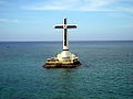
Sunken Cemetery
During the volcanic birth of the Mt. Vulcan that lasted from 1871 to about 1875, some areas in the town of Bonbon subsided, sinking the cemetery of the town to below sea level. The place is commemorated by a huge cross erected in 1982.Waterfalls
- Katibawasan Falls. Located 5 km. (3.1 mi) southeast of Mambajao, the beautiful Katibawasan Falls cascades 250-foot (76 m.) down to a pool surrounded by orchids and ferns. An invigorating dip on the pool is popular especially on warmer days and several hiking trails are within the park. This is also the favorite jump-off point for trekkers and mountaineers in search of adventure on the slopes of Mt. Hibok-Hibok.
- Tuasan Falls is located 6 km. (3.7 mi) northeast of Catarman. Getting to the falls entails a very scenic hike passing through the quaint Barrio of Mainit, Catarman and along the rocky river bed. The pool below the waterfalls is deep and clear. The surrounding scenery is unspoiled and perfect for a peaceful picnic, the only sounds around you is that of the tumbling falls and running water.
Springs
- Ardent Hot Spring. Located at the foot of Hibok-Hibok Volcano bubbles the mineral pools of Ardent Hot Springs. Wisps of steam can be seen rising from the running waters heated up by the cauldron of the mountain, the most recently active of the seven volcanoes on the island.
- Sto. Niño Cold Springs and Bura Natural Soda Water Swimming Pool in Catarman are other popular places to get a relaxing dip on the island.
- Tangub Hot Spring is an interesting hot spring located on the shore close to the Sunken Cemetery. Most of the spring is submerged and can be partly seen during low tide. The spring can also be examined by scuba diving or snorkeling, as visibility is excellent and it is also a recommended spot for observing underwater life.
Transportation
Camiguin is accessible by air and sea from Cebu CityCebu City
The City of Cebu is the capital city of Cebu and is the second largest city in the Philippines, the second most significant metropolitan centre in the Philippines and known as the oldest settlement established by the Spaniards in the country.The city is located on the eastern shore of Cebu and was...
and Tagbilaran City
Tagbilaran City
Tagbilaran City is a 2nd class component city in the island province of Bohol, Philippines and serves as its capital. Tagbilaran lies on the southwestern part of the province, and has a total land area of 32.7 km², with about 13 km of coastline...
however flights into Camiguin Airport is only seasonal. Most visitors fly in to Cagayan de Oro City
Cagayan de Oro City
Cagayan de Oro; , officially the City of Cagayan de Oro, is the provincial capital city of the province of Misamis Oriental in the Philippines...
in Misamis Oriental
Misamis Oriental
Misamis Oriental is a province of the Philippines located in the Northern Mindanao region. Its capital and provincial center is Cagayan de Oro City...
Province, the gateway to Northern Mindanao
Northern Mindanao
Designated as Region X of the Philippines, Northern Mindanao is composed of five provinces and two cities classified as highly-urbanized, all occupying the north-central part of Mindanao island, and the island-province of Camiguin...
. One would then take a bus or hired van for two, more or less, hours from Cagayan de Oro City to the port of Balingoan. Ferries leave Balingoan to Camiguin Island every hour from 6:00 am until 5:00 pm.
External links
- Province of Camiguin official website
- Map of Camiguin from Visayan Silent Gardens