
Mindanao
Encyclopedia
Mindanao mɪndəˈnaʊ is the second largest and easternmost island in the Philippines
. It is also the name of one of the three island groups in the country, which consists of the island of Mindanao and smaller surrounding islands. The other two are Luzon
and the Visayas
. The island of Mindanao is called The Land of Promise. Mindanao is the only area of the Philippines
with a significant Muslim
presence.
Mindanao has been the site of a separatist movement by the Moro Islamic Liberation Front
(MILF), caused by religious differences and widespread poverty. Fighting between MILF and Philippine forces has displaced over 100,000 people.
 Mindanao is named after the Maguindanaons
who constituted the largest Sultanate historically, and evidence from maps made during the 17th and 18th centuries suggests that the name was used to refer to the island
by natives at the time. Evidence of human occupation dates back tens of thousands of years. In prehistoric times the Negrito
people arrived. Sometime around 1500 BC Austronesian people
s spread throughout the Philippines
and far beyond.
Islam
first spread to the region during the 13th century through Arab traders from present-day Malaysia and Indonesia
. Prior to this contact, the inhabitants of the area were primarily animists living in small autonomous communities. The indigenous population was quickly converted and the first mosque
in the Philippines was built in the mid 14th century in the town of Simunul. The Philippine sultanates of Sulu and Maguindanao were subsequently in the 15th and 16th centuries, respectively. In the late 16th to early 17th centuries, the first contact with Spain
occurred. By this time, Islam
was well established in Mindanao and had started influencing groups as far north as present-day Manila
on the island of Luzon
.
Upon the Spaniards' arrival to the Philippines
, they were dismayed to find such a strong Muslim presence on the island
, having just expelled the Moors
from Spain
after centuries of fighting. In fact, the name Moros (the Spanish word for "Moors") was given to the Muslim inhabitants by the Spanish.
Today, the region is home to most of the country's Muslim
or Moro populations, composed of many ethnic groups such as the Maranao
and the Tausug, the Banguingui
(users of the vinta
), as well as the collective group of indigenous tribes known as the Lumad
.
in the country at 94,630 square kilometers, and is the eighth most populous island in the world. The island of Mindanao is larger than 125 countries worldwide, including the Netherlands
, Austria
, Portugal
, Czech Republic
, Hungary
, Taiwan
and Ireland
. The island is mountainous, and is home to Mount Apo
, the highest mountain in the country. Mindanao is surrounded by seas: the Sulu Sea
to the west, the Philippine Sea
to the east, and the Celebes Sea
to the south. Of all the islands of the Philippines
, Mindanao and Borneo shows the greatest variety of physiographic development. High, rugged, faulted mountains; almost isolated volcanic peaks; high rolling plateaus; and broad, level, swampy plains are found there.
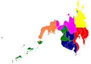
The island group of Mindanao encompasses Mindanao island itself and the Sulu Archipelago
to the southwest. The island group is divided into six regions
, which are further subdivided into 26 provinces
.
 The mountains of Mindanao can be conveniently grouped into five ranges, including both complex structural mountains and volcanoes. The structural mountains on the extreme eastern and western portions of the island
show broad exposures of Mesozoic rock with ultrabasic rocks at the surface in many places along the east coast. Surface rock in other areas of the island is mainly Tertiary
and Quaternary
volcanic or sedimentary.
Paralleling the east coast, from Bilas Point in Surigao del Norte
to Cape Agustin in southeast Davao, is a range of complex mountains known in their northern portion as the Diwata Mountains. This range is low and rolling in its central portion. A proposed road connecting Bislig on the east coast with the Agusan River
would pass through a ten-mile (16 km) broad saddle across the mountains at a maximum elevation of less than 250 meters, while the existing east-west road from Lianga, 30 miles (48.3 km) north of Bislig, reaches a maximum elevation of only 450 meters. The Diwata Mountains, north of these low points, are considerably higher and more rugged, reaching an elevation of 2,012 meters in Mount Hilonghilong, 17 miles (27.4 km) northeast of Butuan City
. The southern portion of this east coast range is broader and even more rugged than the northern section. In eastern Davao, several peaks rise above 2,500 meters and one unnamed mountain rises to 2,810 meters.
The east-facing coastal regions of Davao and Surigao del Sur are marked by a series of small coastal lowlands separated from each other by rugged forelands which extend to the water’s edge. Offshore are numerous coral reefs and tiny islets. This remote and forbidding coast is made doubly difficult to access during the months from October to March by the heavy surf driven before the northeast trade winds. A few miles offshore is found the Mindanao or Philippine Deep. This ocean trench, reaching measured depths of 35400 feet (10,789.9 m), marks one of the greatest depths known on the earth’s surface.
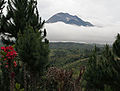
A second north-south range extends along the western borders of Agusan
and Davao
provinces from Camiguin Island
in the north to Tinaca Point in the south. This range is mainly structural in origin, but it also contains at least three active volcano peaks. In the central and northern portions of this range, there are several peaks between 2,000 and 2,500 meters, and here the belt of mountains is about 30 miles (48.3 km) across. West of Davao City
are two active volcanoes: Mount Talomo at 2,693 meters and Mount Apo
at 2,954 meters. Mount Apo is the highest point in the Philippines and dominates the skyline. South of Mount Apo, this central mountain belt is somewhat lower than it is to the north, with peaks averaging only 1,100 to 1,800 meters.
In Western Mindanao, a range of complex structural mountains forms the long, hand-like Zamboanga Peninsula
. These mountains, reaching heights of only 1,200 meters, are not as high as the other structural belts in Mindanao. In addition, there are several places in the Zamboanga Mountains where small inter-mountain basins have been created, with some potential for future agricultural development. The northeastern end of this range is marked by the twin peaks of the now extinct volcano, Mount Malindang
, which rise splendidly behind Ozamis City to a height of 2,425 meters. Mount Dapia is the highest mountain in the Zamboanga Peninsula, reaching a height of 2,617 meters (8,586 ft). Meanwhile, Batorampon Point
is the highest mountain of the southernmost end of the peninsula, reaching a height of only 1,335 meters (4,380 ft); it is located in the boundary of Zamboanga City
.
A series of volcanic mountains is found near Lake Lanao
in a broad arc through Lanao del Sur
, northern Cotabato
and western Bukidnon
provinces. At least six of the twenty odd peaks in this area are active and several are very impressive as they stand in semi-isolation. The Butig Peaks, with their four crater lakes, are easily seen from Cotabato. Mount Ragang, an active volcano cone reaching 2,815 meters, is the most isolated, while the greatest height is reached by Mount Kitanglad
at 2,896 meters.
In southwestern Cotabato
, still another range of volcanic mountains is found, this time paralleling the coast. These mountains have a maximum extent of 110 miles (177 km) from northwest to southeast and measure some 30 miles (48.3 km) across. One of the well-known mountains here is Mount Parker
, whose almost circular crater lake
measures a mile and a quarter in diameter and lies 300 meters below its 2,040-meter summit. Mount Matutum is a protected area and is considered as one of the major landmarks of South Cotabato
Province.
A second important physiographic division of Mindanao is the series of upland plateaus in Bukidnon
and Lanao del Sur
provinces. These plateaus are rather extensive and almost surround several volcanoes in this area. The plateaus are made up of basaltic lava flows interbedded with ash and volcanic tuff. Near their edges, the plateaus are cut by deep canyons, and at several points spectacular waterfalls drop to the narrow coastal plain. These falls hold considerable promise for development of hydroelectric energy. Indeed, one such site at Maria Cristina Falls
has already become a major producer. Because the rolling plateaus lie at an elevation averaging 700 meters above sea level, they offer relief from the often oppressive heat of the coastal lowlands. Lake Lanao
occupies the major portion of one such plateau in Lanao del Sur
. This largest lake on Mindanao and second in the country is roughly triangular in shape with an 18 miles (29 km)-long base. Having a surface at 780 meters above sea level, and being rimmed on the east, south and west by series of peaks reaching 2,300 meters, the lake provides a scenic grandeur and pleasant temperature seldom equaled in the country. Marawi City, at the northern tip of the lake, is bisected by the Agus River
, which feeds the Maria Cristina Falls
.
Another of Mindanao’s spectacular waterfall sites is located in Malabang, 15 miles (24.1 km) south of Lake Lanao
. Here the Jose Abad Santos Falls present one of the nation’s scenic wonders at the gateway to a 200-hectare national park development.
The Limunsudan Falls, with an approximate height of 800 ft (243.8 m), is the highest waterfalls in the Philippines; it is located at Iligan City
.
and Mindanao
rivers in Agusan
and Cotabato
Provinces, respectively. There is some indication that the Agusan Valley occupies a broad syncline between the central mountains and the east-coast mountains. This valley measures 110 miles (177 km) from south to north and varies from 20 to 30 miles (48.3 km) in width. 35 miles (56.3 km) north of the head of Davao Gulf
lies the watershed between the Agusan and the tributaries of the Libuganon River, which flows to the Gulf. The elevation of this divide is well under 200 meters, indicating the almost continuous nature of the lowland from the Mindanao Sea on the north to the Davao Gulf
.
The Mindanao River
and its main tributaries, the Catisan and the Pulangi
, form a valley with a maximum length of 120 miles (193.1 km) and a width which varies from 12 miles (19.3 km) at the river mouth to about 60 miles (96.6 km) in central Cotabato
. The southern extensions of this Cotabato Valley extend uninterrupted across a 350-meter watershed from Illana Bay
on the northwest to Sarangani Bay
on the southeast.
Other lowlands of a coastal nature are to be found in various parts of Mindanao. Many of these are tiny isolated pockets, as along the northwest coast of Zamboanga
. In other areas such as the Davao Plain, these coastal lowlands are as much as ten miles (16 km) wide and several times that length.
From Dipolog City
eastward along the northern coast of Mindanao almost to Butuan City
extends a rolling coastal plain of varying width. In Misamis Occidental
, the now dormant Mount Malindang
has created a lowland averaging eight miles (13 km) in width. Shallow Panquil Bay
divides this province from Lanao del Norte
, and is bordered by low-lying, poorly drained lowlands and extensive mangroves. In Misamis Oriental
, the plain is narrower and in places almost pinched out by rugged forelands which reach to the sea. East of Cagayan de Oro, a rugged peninsula extends well into the Mindanao Sea.
is spoken by the majority of people in Mindanao. Cebuano is generally the native language in most regions, except for the Muslim areas on the west coast and among the hill tribes.
The Spanish-based creole
, Chavacano
is the official language
of Zamboanga City
and the lingua franca
in other parts of Zamboanga Peninsula
and Basilan Province. The dialect Zamboangueño Chavacano is one of the six dialects of Chavacano (whose native speakers are known as the Zamboangueño Latino
). Zamboangueño Chavacano is also spoken as a minority language in some other points of Mindanao such as Davao
and Cotabato
. Zamboangueño Chavacano is also recognized as minority language in Sabah
, Malaysia as well.
There are still a number of Spanish speakers, most of them elderly members of mestizo families.
Christians form the majority, with 63% of the population; Muslims are 32% of the population (mostly on the southern part of the island); 5% are affiliated with other religions. The native Maguindanaon and other native Muslim or non-Muslim groups of Mindanao have a culture that is different from the main cultures of the Southern Philippines.
 The island group of Mindanao is an arbitrary grouping of islands in the Southern Philippines which encompasses six administrative regions
. These regions are further subdivided into 26 provinces
, of which only four are not on Mindanao island
itself. Some of the areas are semi-autonomous Muslim areas. The island group includes the Sulu Archipelago
to the southwest, which consists of the major islands of Basilan
, Jolo
, and Tawi-Tawi
, plus outlying islands in other areas such as Camiguin
, Dinagat
, Siargao
, Samal
.
The six regions are:
Mindanao is composed of 26 provinces
, each headed by a Governor. A governor is elected by popular vote and can serve a maximum of three terms consisting of three years each.
As for representation in the Philippine Congress
, Mindanao is represented by 46 Congressmen elected in the same manner as the governors.
. Its provinces are:
. The provinces and cities are:
. Its provinces are:
. It's provinces are:
Philippines
The Philippines , officially known as the Republic of the Philippines , is a country in Southeast Asia in the western Pacific Ocean. To its north across the Luzon Strait lies Taiwan. West across the South China Sea sits Vietnam...
. It is also the name of one of the three island groups in the country, which consists of the island of Mindanao and smaller surrounding islands. The other two are Luzon
Luzon
Luzon is the largest island in the Philippines. It is located in the northernmost region of the archipelago, and is also the name for one of the three primary island groups in the country centered on the Island of Luzon...
and the Visayas
Visayas
The Visayas or Visayan Islands and locally known as Kabisay-an gid, is one of the three principal geographical divisions of the Philippines, along with Mindanao and Luzon. It consists of several islands, primarily surrounding the Visayan Sea, although the Visayas are considered the northeast...
. The island of Mindanao is called The Land of Promise. Mindanao is the only area of the Philippines
Islam in the Philippines
Islam is the oldest recorded monotheistic religion in the Philippines. Islam reached the Philippines between the 12th and 14th century with the arrival of Muslim traders from Persian Gulf and the Malabar Coast in Southern India, and their followers from several sultanate governments in the Malay...
with a significant Muslim
Muslim
A Muslim, also spelled Moslem, is an adherent of Islam, a monotheistic, Abrahamic religion based on the Quran, which Muslims consider the verbatim word of God as revealed to prophet Muhammad. "Muslim" is the Arabic term for "submitter" .Muslims believe that God is one and incomparable...
presence.
Mindanao has been the site of a separatist movement by the Moro Islamic Liberation Front
Moro Islamic Liberation Front
The Moro Islamic Liberation Front is an Islamist group located in the southern Philippines. It is one of two Islamic militant groups, the other being the Abu Sayyaf, that are fighting against Government of the Philippines...
(MILF), caused by religious differences and widespread poverty. Fighting between MILF and Philippine forces has displaced over 100,000 people.
History
Maguindanao people
The Maguindanao are part of the wider Moro ethnic group, who constitute the sixth largest Filipino ethnic group. Their name means “people of the plains”.-Pre-Spanish:...
who constituted the largest Sultanate historically, and evidence from maps made during the 17th and 18th centuries suggests that the name was used to refer to the island
Island
An island or isle is any piece of sub-continental land that is surrounded by water. Very small islands such as emergent land features on atolls can be called islets, cays or keys. An island in a river or lake may be called an eyot , or holm...
by natives at the time. Evidence of human occupation dates back tens of thousands of years. In prehistoric times the Negrito
Negrito
The Negrito are a class of several ethnic groups who inhabit isolated parts of Southeast Asia.Their current populations include 12 Andamanese peoples of the Andaman Islands, six Semang peoples of Malaysia, the Mani of Thailand, and the Aeta, Agta, Ati, and 30 other peoples of the Philippines....
people arrived. Sometime around 1500 BC Austronesian people
Austronesian people
The Austronesian-speaking peoples are various populations in Oceania and Southeast Asia that speak languages of the Austronesian family. They include Taiwanese aborigines; the majority ethnic groups of East Timor, Indonesia, Malaysia, the Philippines, Brunei, Madagascar, Micronesia, and Polynesia,...
s spread throughout the Philippines
Philippines
The Philippines , officially known as the Republic of the Philippines , is a country in Southeast Asia in the western Pacific Ocean. To its north across the Luzon Strait lies Taiwan. West across the South China Sea sits Vietnam...
and far beyond.
Islam
Islam
Islam . The most common are and . : Arabic pronunciation varies regionally. The first vowel ranges from ~~. The second vowel ranges from ~~~...
first spread to the region during the 13th century through Arab traders from present-day Malaysia and Indonesia
Indonesia
Indonesia , officially the Republic of Indonesia , is a country in Southeast Asia and Oceania. Indonesia is an archipelago comprising approximately 13,000 islands. It has 33 provinces with over 238 million people, and is the world's fourth most populous country. Indonesia is a republic, with an...
. Prior to this contact, the inhabitants of the area were primarily animists living in small autonomous communities. The indigenous population was quickly converted and the first mosque
Mosque
A mosque is a place of worship for followers of Islam. The word is likely to have entered the English language through French , from Portuguese , from Spanish , and from Berber , ultimately originating in — . The Arabic word masjid literally means a place of prostration...
in the Philippines was built in the mid 14th century in the town of Simunul. The Philippine sultanates of Sulu and Maguindanao were subsequently in the 15th and 16th centuries, respectively. In the late 16th to early 17th centuries, the first contact with Spain
Spain
Spain , officially the Kingdom of Spain languages]] under the European Charter for Regional or Minority Languages. In each of these, Spain's official name is as follows:;;;;;;), is a country and member state of the European Union located in southwestern Europe on the Iberian Peninsula...
occurred. By this time, Islam
Islam
Islam . The most common are and . : Arabic pronunciation varies regionally. The first vowel ranges from ~~. The second vowel ranges from ~~~...
was well established in Mindanao and had started influencing groups as far north as present-day Manila
Manila
Manila is the capital of the Philippines. It is one of the sixteen cities forming Metro Manila.Manila is located on the eastern shores of Manila Bay and is bordered by Navotas and Caloocan to the north, Quezon City to the northeast, San Juan and Mandaluyong to the east, Makati on the southeast,...
on the island of Luzon
Luzon
Luzon is the largest island in the Philippines. It is located in the northernmost region of the archipelago, and is also the name for one of the three primary island groups in the country centered on the Island of Luzon...
.
Upon the Spaniards' arrival to the Philippines
Philippines
The Philippines , officially known as the Republic of the Philippines , is a country in Southeast Asia in the western Pacific Ocean. To its north across the Luzon Strait lies Taiwan. West across the South China Sea sits Vietnam...
, they were dismayed to find such a strong Muslim presence on the island
Island
An island or isle is any piece of sub-continental land that is surrounded by water. Very small islands such as emergent land features on atolls can be called islets, cays or keys. An island in a river or lake may be called an eyot , or holm...
, having just expelled the Moors
Moors
The description Moors has referred to several historic and modern populations of the Maghreb region who are predominately of Berber and Arab descent. They came to conquer and rule the Iberian Peninsula for nearly 800 years. At that time they were Muslim, although earlier the people had followed...
from Spain
Spain
Spain , officially the Kingdom of Spain languages]] under the European Charter for Regional or Minority Languages. In each of these, Spain's official name is as follows:;;;;;;), is a country and member state of the European Union located in southwestern Europe on the Iberian Peninsula...
after centuries of fighting. In fact, the name Moros (the Spanish word for "Moors") was given to the Muslim inhabitants by the Spanish.
Today, the region is home to most of the country's Muslim
Islam in the Philippines
Islam is the oldest recorded monotheistic religion in the Philippines. Islam reached the Philippines between the 12th and 14th century with the arrival of Muslim traders from Persian Gulf and the Malabar Coast in Southern India, and their followers from several sultanate governments in the Malay...
or Moro populations, composed of many ethnic groups such as the Maranao
Maranao
Maranao is the term used for the people of Lanao, a predominantly Muslim region in the Philippines island of Mindanao. They are famous for their artwork, sophisticated weaving, wood and metal craft, and their epic literature...
and the Tausug, the Banguingui
Banguingui
Banguingui, also known as Sama Banguingui, Sama Bangingi’, Bangingi, and Samal Banguingui, is a distinct ethno-linguistic group dispersed throughout the Greater Sulu Archipelago and southern and western coastal regions of the Zamboanga Peninsula in Mindanao.-People:The Banguingui are not officially...
(users of the vinta
Vinta
The vinta is a traditional boat found in the Philippine island of Mindanao. These boats are made by Bajau and Moros lining in the Sulu Archipelago. It has a sail with assorted vertical colors that represents the colorful culture and history of the Muslim community. These boats are used for...
), as well as the collective group of indigenous tribes known as the Lumad
Lumad
The Lumad is a term being used to denote a group of indigenous peoples of the southern Philippines. It is a Cebuano term meaning "native" or "indigenous"...
.
Geography
Mindanao is the second largest islandIsland
An island or isle is any piece of sub-continental land that is surrounded by water. Very small islands such as emergent land features on atolls can be called islets, cays or keys. An island in a river or lake may be called an eyot , or holm...
in the country at 94,630 square kilometers, and is the eighth most populous island in the world. The island of Mindanao is larger than 125 countries worldwide, including the Netherlands
Netherlands
The Netherlands is a constituent country of the Kingdom of the Netherlands, located mainly in North-West Europe and with several islands in the Caribbean. Mainland Netherlands borders the North Sea to the north and west, Belgium to the south, and Germany to the east, and shares maritime borders...
, Austria
Austria
Austria , officially the Republic of Austria , is a landlocked country of roughly 8.4 million people in Central Europe. It is bordered by the Czech Republic and Germany to the north, Slovakia and Hungary to the east, Slovenia and Italy to the south, and Switzerland and Liechtenstein to the...
, Portugal
Portugal
Portugal , officially the Portuguese Republic is a country situated in southwestern Europe on the Iberian Peninsula. Portugal is the westernmost country of Europe, and is bordered by the Atlantic Ocean to the West and South and by Spain to the North and East. The Atlantic archipelagos of the...
, Czech Republic
Czech Republic
The Czech Republic is a landlocked country in Central Europe. The country is bordered by Poland to the northeast, Slovakia to the east, Austria to the south, and Germany to the west and northwest....
, Hungary
Hungary
Hungary , officially the Republic of Hungary , is a landlocked country in Central Europe. It is situated in the Carpathian Basin and is bordered by Slovakia to the north, Ukraine and Romania to the east, Serbia and Croatia to the south, Slovenia to the southwest and Austria to the west. The...
, Taiwan
Taiwan
Taiwan , also known, especially in the past, as Formosa , is the largest island of the same-named island group of East Asia in the western Pacific Ocean and located off the southeastern coast of mainland China. The island forms over 99% of the current territory of the Republic of China following...
and Ireland
Ireland
Ireland is an island to the northwest of continental Europe. It is the third-largest island in Europe and the twentieth-largest island on Earth...
. The island is mountainous, and is home to Mount Apo
Mount Apo
Mount Apo is a large solfataric, potentially-active stratovolcano in the island of Mindanao, Philippines. With an altitude of , it is the highest mountain in the country and is located between Davao City and Davao del Sur province in Region XI and Cotabato province in Region XII...
, the highest mountain in the country. Mindanao is surrounded by seas: the Sulu Sea
Sulu Sea
The Sulu Sea is a body of water in the southwestern area of the Philippines, separated from the South China Sea in the northwest by Palawan and from the Celebes Sea in the southeast by the Sulu Archipelago. Borneo is found to the southwest and Visayas to the northeast.Sulu Sea contains a number of...
to the west, the Philippine Sea
Philippine Sea
The Philippine Sea is a marginal sea east and north of the Philippines occupying an estimated surface area of 2 million mi² on the western part of the North Pacific Ocean...
to the east, and the Celebes Sea
Celebes Sea
The Celebes Sea of the western Pacific Ocean is bordered on the north by the Sulu Archipelago and Sulu Sea and Mindanao Island of the Philippines, on the east by the Sangihe Islands chain, on the south by Sulawesi, and on the west by Kalimantan in Indonesia...
to the south. Of all the islands of the Philippines
Philippines
The Philippines , officially known as the Republic of the Philippines , is a country in Southeast Asia in the western Pacific Ocean. To its north across the Luzon Strait lies Taiwan. West across the South China Sea sits Vietnam...
, Mindanao and Borneo shows the greatest variety of physiographic development. High, rugged, faulted mountains; almost isolated volcanic peaks; high rolling plateaus; and broad, level, swampy plains are found there.
The island group of Mindanao encompasses Mindanao island itself and the Sulu Archipelago
Sulu Archipelago
The Sulu Archipelago is a chain of islands in the southwestern Philippines. This archipelago is considered to be part of the Moroland by the local rebel independence movement. This island group forms the northern limit of the Celebes Sea....
to the southwest. The island group is divided into six regions
Regions of the Philippines
In the Philippines, regions are administrative divisions that serve primarily to organize the provinces of the country for administrative convenience. Currently, the archipelagic republic of the Philippines is divided into 17 regions...
, which are further subdivided into 26 provinces
Provinces of the Philippines
The Provinces of the Philippines are the primary political and administrative divisions of the Philippines. There are 80 provinces at present, further subdivided into component cities and municipalities. The National Capital Region, as well as independent cities, are autonomous from any provincial...
.
Mountains and plateaus
Island
An island or isle is any piece of sub-continental land that is surrounded by water. Very small islands such as emergent land features on atolls can be called islets, cays or keys. An island in a river or lake may be called an eyot , or holm...
show broad exposures of Mesozoic rock with ultrabasic rocks at the surface in many places along the east coast. Surface rock in other areas of the island is mainly Tertiary
Tertiary
The Tertiary is a deprecated term for a geologic period 65 million to 2.6 million years ago. The Tertiary covered the time span between the superseded Secondary period and the Quaternary...
and Quaternary
Quaternary
The Quaternary Period is the most recent of the three periods of the Cenozoic Era in the geologic time scale of the ICS. It follows the Neogene Period, spanning 2.588 ± 0.005 million years ago to the present...
volcanic or sedimentary.
Paralleling the east coast, from Bilas Point in Surigao del Norte
Surigao del Norte
Surigao del Norte is a province of the Philippines located in the Caraga region in Mindanao. Its capital is Surigao City. The province consists of two major islands—Siargao Island and Bucas Grande Island—in the Philippine Sea, and a small region at the northernmost tip of the island of...
to Cape Agustin in southeast Davao, is a range of complex mountains known in their northern portion as the Diwata Mountains. This range is low and rolling in its central portion. A proposed road connecting Bislig on the east coast with the Agusan River
Agusan River
Agusan River is a river located in the eastern part of Mindanao island in the Philippines, draining majority of the Caraga Region and some parts of Compostela Valley province. It is the third largest river basin of the Philippines with a total drainage area of 10,921 km² and an estimated...
would pass through a ten-mile (16 km) broad saddle across the mountains at a maximum elevation of less than 250 meters, while the existing east-west road from Lianga, 30 miles (48.3 km) north of Bislig, reaches a maximum elevation of only 450 meters. The Diwata Mountains, north of these low points, are considerably higher and more rugged, reaching an elevation of 2,012 meters in Mount Hilonghilong, 17 miles (27.4 km) northeast of Butuan City
Butuan City
The City of Butuan is the regional center of Caraga, serving as an administrative region of the Philippines; it is a highly urbanized city. It is located at the northeastern part of Agusan Valley, Mindanao, sprawling across the Agusan River. It is bounded to the north, west and south by Agusan del...
. The southern portion of this east coast range is broader and even more rugged than the northern section. In eastern Davao, several peaks rise above 2,500 meters and one unnamed mountain rises to 2,810 meters.
The east-facing coastal regions of Davao and Surigao del Sur are marked by a series of small coastal lowlands separated from each other by rugged forelands which extend to the water’s edge. Offshore are numerous coral reefs and tiny islets. This remote and forbidding coast is made doubly difficult to access during the months from October to March by the heavy surf driven before the northeast trade winds. A few miles offshore is found the Mindanao or Philippine Deep. This ocean trench, reaching measured depths of 35400 feet (10,789.9 m), marks one of the greatest depths known on the earth’s surface.
A second north-south range extends along the western borders of Agusan
Agusan
-In geograph:* Agusan in the Philipines** Agusan del Norte in the Philipines** Agusan del Sur in the Philipines*Agusan River, a river in Mindanao* Legislative district of Agusan in the Philipines...
and Davao
Davao Region
Davao Region / Southern Mindanao, designated as Region XI, is one of the regions of the Philippines, located on the southeastern portion of Mindanao. Davao Region consists of four provinces, namely: Compostela Valley, Davao del Norte, Davao Oriental, and Davao del Sur. The region encloses the Davao...
provinces from Camiguin Island
Camiguin
Camiguin is an island province of the Philippines located in the Bohol Sea, about off the northern coast of Misamis Oriental in Mindanao. It is the second-smallest province both in population and land area after Batanes...
in the north to Tinaca Point in the south. This range is mainly structural in origin, but it also contains at least three active volcano peaks. In the central and northern portions of this range, there are several peaks between 2,000 and 2,500 meters, and here the belt of mountains is about 30 miles (48.3 km) across. West of Davao City
Davao City
The City of Davao is the largest city in the island of Mindanao in the Philippines. Its international airport and seaports are among the busiest cargo hubs in the Philippines....
are two active volcanoes: Mount Talomo at 2,693 meters and Mount Apo
Mount Apo
Mount Apo is a large solfataric, potentially-active stratovolcano in the island of Mindanao, Philippines. With an altitude of , it is the highest mountain in the country and is located between Davao City and Davao del Sur province in Region XI and Cotabato province in Region XII...
at 2,954 meters. Mount Apo is the highest point in the Philippines and dominates the skyline. South of Mount Apo, this central mountain belt is somewhat lower than it is to the north, with peaks averaging only 1,100 to 1,800 meters.
In Western Mindanao, a range of complex structural mountains forms the long, hand-like Zamboanga Peninsula
Zamboanga Peninsula (geographical region)
Zamboanga Peninsula is long, semicircular peninsula located in northwestern Mindanao, the Philippines, extending southwesterly toward the Sulu Archipelago and Borneo. It has an area of roughly 5,600 square miles . The peninsula was connected to the main part of Mindanao through an isthmus situated...
. These mountains, reaching heights of only 1,200 meters, are not as high as the other structural belts in Mindanao. In addition, there are several places in the Zamboanga Mountains where small inter-mountain basins have been created, with some potential for future agricultural development. The northeastern end of this range is marked by the twin peaks of the now extinct volcano, Mount Malindang
Mount Malindang
Mount Malindang is a complex volcano located in the province of Misamis Occidental in the southern island of Mindanao, Philippines. The least studied mountain range was formed through several volcanic activities some of which could be historical, evident by the presence of two calderas, surrounded...
, which rise splendidly behind Ozamis City to a height of 2,425 meters. Mount Dapia is the highest mountain in the Zamboanga Peninsula, reaching a height of 2,617 meters (8,586 ft). Meanwhile, Batorampon Point
Batorampon Point
Batorampon Point is the westernmost point of the island of Mindanao in the Philippines and has been named so since the mid-19th century. The rocky cliff, located within the limits of the City of Zamboanga, was previously known as Batalampon Point, becoming Batorampon Point in the 1940s...
is the highest mountain of the southernmost end of the peninsula, reaching a height of only 1,335 meters (4,380 ft); it is located in the boundary of Zamboanga City
Zamboanga City
The City of Zamboanga : is a highly urbanized, independent and a chartered city located in Mindanao, Philippines....
.
A series of volcanic mountains is found near Lake Lanao
Lake Lanao
Lake Lanao is a large lake in the Philippines, located in Lanao del Sur province in the country's southern island of Mindanao. With a surface area of 340 km²...
in a broad arc through Lanao del Sur
Lanao del Sur
Lanao del Sur is a province of the Philippines located in the Autonomous Region in Muslim Mindanao . Its capital is Marawi City and borders Lanao del Norte to the north, Bukidnon to the east, and Maguindanao and Cotabato to the south. To the southwest lies Illana Bay, an arm of the Moro Gulf...
, northern Cotabato
Cotabato
Cotabato , is a landlocked province of the Philippines located in the SOCCSKSARGEN region in Mindanao...
and western Bukidnon
Bukidnon
Bukidnon is a landlocked province of the Philippines located in the Northern Mindanao region. Its capital is Malaybalay City. The province borders, clockwise starting from the north, Misamis Oriental, Agusan del Sur, Davao del Norte, Cotabato, Lanao del Sur, and Lanao del Norte.Bukidnon is...
provinces. At least six of the twenty odd peaks in this area are active and several are very impressive as they stand in semi-isolation. The Butig Peaks, with their four crater lakes, are easily seen from Cotabato. Mount Ragang, an active volcano cone reaching 2,815 meters, is the most isolated, while the greatest height is reached by Mount Kitanglad
Mount Kitanglad
Mount Kitanglad is an inactive volcanic volcano located in the Kitanglad Mountain Range in Bukidnon province on Mindanao island. It is officially declared as the fourth highest mountain in the Philippines and has an approximate height of 2,899 meters...
at 2,896 meters.
In southwestern Cotabato
Cotabato
Cotabato , is a landlocked province of the Philippines located in the SOCCSKSARGEN region in Mindanao...
, still another range of volcanic mountains is found, this time paralleling the coast. These mountains have a maximum extent of 110 miles (177 km) from northwest to southeast and measure some 30 miles (48.3 km) across. One of the well-known mountains here is Mount Parker
Mount Parker (Cotabato)
Mount Parker, locally known as Melibengoy, is a stratovolcano on Mindanao island in the Philippines . It is located in the province of South Cotabato, 30 kilometers west of General Santos City and 44 kilometers south of Koronadal City.The volcano's English name is taken from an American...
, whose almost circular crater lake
Crater lake
A crater lake is a lake that forms in a volcanic crater or caldera, such as a maar; less commonly and with lower association to the term a lake may form in an impact crater caused by a meteorite. Sometimes lakes which form inside calderas are called caldera lakes, but often this distinction is not...
measures a mile and a quarter in diameter and lies 300 meters below its 2,040-meter summit. Mount Matutum is a protected area and is considered as one of the major landmarks of South Cotabato
South Cotabato
South Cotabato is a province of the Philippines located in the SOCCSKSARGEN region in Mindanao. Its capital is Koronadal City, and it borders Sultan Kudarat to the north and west, Sarangani to the south and east, and Davao del Sur to the east...
Province.
A second important physiographic division of Mindanao is the series of upland plateaus in Bukidnon
Bukidnon
Bukidnon is a landlocked province of the Philippines located in the Northern Mindanao region. Its capital is Malaybalay City. The province borders, clockwise starting from the north, Misamis Oriental, Agusan del Sur, Davao del Norte, Cotabato, Lanao del Sur, and Lanao del Norte.Bukidnon is...
and Lanao del Sur
Lanao del Sur
Lanao del Sur is a province of the Philippines located in the Autonomous Region in Muslim Mindanao . Its capital is Marawi City and borders Lanao del Norte to the north, Bukidnon to the east, and Maguindanao and Cotabato to the south. To the southwest lies Illana Bay, an arm of the Moro Gulf...
provinces. These plateaus are rather extensive and almost surround several volcanoes in this area. The plateaus are made up of basaltic lava flows interbedded with ash and volcanic tuff. Near their edges, the plateaus are cut by deep canyons, and at several points spectacular waterfalls drop to the narrow coastal plain. These falls hold considerable promise for development of hydroelectric energy. Indeed, one such site at Maria Cristina Falls
María Cristina Falls
Maria Cristina Falls is a waterfall of the Agus River on the island of Mindanao. It is sometimes called the "twin falls" as the flow is separated by a rock at the brink of the waterfall. It is a landmark of Iligan City, nicknamed the City of Majestic Waterfalls, because of the presence of more...
has already become a major producer. Because the rolling plateaus lie at an elevation averaging 700 meters above sea level, they offer relief from the often oppressive heat of the coastal lowlands. Lake Lanao
Lake Lanao
Lake Lanao is a large lake in the Philippines, located in Lanao del Sur province in the country's southern island of Mindanao. With a surface area of 340 km²...
occupies the major portion of one such plateau in Lanao del Sur
Lanao del Sur
Lanao del Sur is a province of the Philippines located in the Autonomous Region in Muslim Mindanao . Its capital is Marawi City and borders Lanao del Norte to the north, Bukidnon to the east, and Maguindanao and Cotabato to the south. To the southwest lies Illana Bay, an arm of the Moro Gulf...
. This largest lake on Mindanao and second in the country is roughly triangular in shape with an 18 miles (29 km)-long base. Having a surface at 780 meters above sea level, and being rimmed on the east, south and west by series of peaks reaching 2,300 meters, the lake provides a scenic grandeur and pleasant temperature seldom equaled in the country. Marawi City, at the northern tip of the lake, is bisected by the Agus River
Agus River
Agus River is a river that flows for 36.5 km from Lanao Lake to Iligan Bay, Philippines. It cuts through the provinces of Lanao del Sur and Lanao del Norte. Settlements along the banks of the river include the City of Marawi, the Municipality of Linamon and the City of Iligan...
, which feeds the Maria Cristina Falls
María Cristina Falls
Maria Cristina Falls is a waterfall of the Agus River on the island of Mindanao. It is sometimes called the "twin falls" as the flow is separated by a rock at the brink of the waterfall. It is a landmark of Iligan City, nicknamed the City of Majestic Waterfalls, because of the presence of more...
.
Another of Mindanao’s spectacular waterfall sites is located in Malabang, 15 miles (24.1 km) south of Lake Lanao
Lake Lanao
Lake Lanao is a large lake in the Philippines, located in Lanao del Sur province in the country's southern island of Mindanao. With a surface area of 340 km²...
. Here the Jose Abad Santos Falls present one of the nation’s scenic wonders at the gateway to a 200-hectare national park development.
The Limunsudan Falls, with an approximate height of 800 ft (243.8 m), is the highest waterfalls in the Philippines; it is located at Iligan City
Iligan City
The City of Iligan is a highly urbanized industrial city north of the province of Lanao del Norte, Philippines, and the province's former capital. It is approximately 795 kilometers southeast of Manila...
.
Plains
Mindanao contains two large inland lowland areas, the valleys of the AgusanAgusan River
Agusan River is a river located in the eastern part of Mindanao island in the Philippines, draining majority of the Caraga Region and some parts of Compostela Valley province. It is the third largest river basin of the Philippines with a total drainage area of 10,921 km² and an estimated...
and Mindanao
Mindanao River
The Mindanao River, also known as the Rio Grande de Mindanao, is the second largest river system in the Philippines, after the Cagayan River of Luzon. It is also the largest river on the southern Philippine island of Mindanao having a drainage area of 23,169 square kilometers, draining majority of...
rivers in Agusan
Agusan
-In geograph:* Agusan in the Philipines** Agusan del Norte in the Philipines** Agusan del Sur in the Philipines*Agusan River, a river in Mindanao* Legislative district of Agusan in the Philipines...
and Cotabato
Cotabato
Cotabato , is a landlocked province of the Philippines located in the SOCCSKSARGEN region in Mindanao...
Provinces, respectively. There is some indication that the Agusan Valley occupies a broad syncline between the central mountains and the east-coast mountains. This valley measures 110 miles (177 km) from south to north and varies from 20 to 30 miles (48.3 km) in width. 35 miles (56.3 km) north of the head of Davao Gulf
Davao Gulf
Davao Gulf is a gulf found in Mindanao in the Philippines. It has an area of 308,000 hectares. Davao Gulf cuts into the island of Mindanao from Celebes Sea. It is surrounded by all four provinces in the Davao Region. The largest island in the gulf is Samal Island. Davao City, on the gulf's west...
lies the watershed between the Agusan and the tributaries of the Libuganon River, which flows to the Gulf. The elevation of this divide is well under 200 meters, indicating the almost continuous nature of the lowland from the Mindanao Sea on the north to the Davao Gulf
Davao Gulf
Davao Gulf is a gulf found in Mindanao in the Philippines. It has an area of 308,000 hectares. Davao Gulf cuts into the island of Mindanao from Celebes Sea. It is surrounded by all four provinces in the Davao Region. The largest island in the gulf is Samal Island. Davao City, on the gulf's west...
.
The Mindanao River
Mindanao River
The Mindanao River, also known as the Rio Grande de Mindanao, is the second largest river system in the Philippines, after the Cagayan River of Luzon. It is also the largest river on the southern Philippine island of Mindanao having a drainage area of 23,169 square kilometers, draining majority of...
and its main tributaries, the Catisan and the Pulangi
Pulangi River
The Pulangi River , also spelled Pulangui, is the longest river in Bukidnon. It is one of the major tributaries of the Rio Grande de Mindanao, an extensive river system in Mindanao, Philippines...
, form a valley with a maximum length of 120 miles (193.1 km) and a width which varies from 12 miles (19.3 km) at the river mouth to about 60 miles (96.6 km) in central Cotabato
Cotabato
Cotabato , is a landlocked province of the Philippines located in the SOCCSKSARGEN region in Mindanao...
. The southern extensions of this Cotabato Valley extend uninterrupted across a 350-meter watershed from Illana Bay
Illana Bay
Illana Bay is a large bay in the southwestern part of Mindanao island, Philippines, at ....
on the northwest to Sarangani Bay
Sarangani Bay
Sarangani Bay is a bay located on the southern tip of Mindanao in the Philippines. It opens up to the Celebes Sea on the Pacific Ocean. General Santos City, one of the Philippines most important cities and ports, is located on the bay, making the bay one of the busiest and often the sight of...
on the southeast.
Other lowlands of a coastal nature are to be found in various parts of Mindanao. Many of these are tiny isolated pockets, as along the northwest coast of Zamboanga
Zamboanga Peninsula
Zamboanga Peninsula / Western Mindanao is a peninsula and an administrative region in the Philippines. Designated as Region IX, the region consists of three provinces, namely, Zamboanga del Norte, Zamboanga del Sur, and Zamboanga Sibugay, its component cities of Dipolog, Dapitan, Pagadian, and...
. In other areas such as the Davao Plain, these coastal lowlands are as much as ten miles (16 km) wide and several times that length.
From Dipolog City
Dipolog City
The City of Dipolog is a 1st class city and the capital of the province of Zamboanga del Norte on the southern Philippine island of Mindanao...
eastward along the northern coast of Mindanao almost to Butuan City
Butuan City
The City of Butuan is the regional center of Caraga, serving as an administrative region of the Philippines; it is a highly urbanized city. It is located at the northeastern part of Agusan Valley, Mindanao, sprawling across the Agusan River. It is bounded to the north, west and south by Agusan del...
extends a rolling coastal plain of varying width. In Misamis Occidental
Misamis Occidental
Misamis Occidental is a province of the Philippines located in the Northern Mindanao region. Its capital is Oroquieta City...
, the now dormant Mount Malindang
Mount Malindang
Mount Malindang is a complex volcano located in the province of Misamis Occidental in the southern island of Mindanao, Philippines. The least studied mountain range was formed through several volcanic activities some of which could be historical, evident by the presence of two calderas, surrounded...
has created a lowland averaging eight miles (13 km) in width. Shallow Panquil Bay
Panquil Bay
Panguil Bay, an arm of Iligan Bay, is a bay in Mindanao in the Philippines. The bay forms the natural boundary separating the Zamboanga Peninsula from the rest of the island of Mindanao. It borders the provinces of Misamis Occidental, Zamboanga del Sur, and Lanao del Norte...
divides this province from Lanao del Norte
Lanao del Norte
Lanao del Norte is a province of the Philippines located in the Northern Mindanao region. Its capital is Tubod. The province borders Lanao del Sur to the southeast, Zamboanga del Sur to the west, Illana Bay to the southwest, Iligan Bay to the north, Iligan City to the northeast, and is separated...
, and is bordered by low-lying, poorly drained lowlands and extensive mangroves. In Misamis Oriental
Misamis Oriental
Misamis Oriental is a province of the Philippines located in the Northern Mindanao region. Its capital and provincial center is Cagayan de Oro City...
, the plain is narrower and in places almost pinched out by rugged forelands which reach to the sea. East of Cagayan de Oro, a rugged peninsula extends well into the Mindanao Sea.
Culture
CebuanoCebuano language
Cebuano, referred to by most of its speakers as Bisaya , is an Austronesian language spoken in the Philippines by about 20 million people mostly in the Central Visayas. It is the most widely spoken of the languages within the so-named Bisayan subgroup and is closely related to other Filipino...
is spoken by the majority of people in Mindanao. Cebuano is generally the native language in most regions, except for the Muslim areas on the west coast and among the hill tribes.
The Spanish-based creole
Creole language
A creole language, or simply a creole, is a stable natural language developed from the mixing of parent languages; creoles differ from pidgins in that they have been nativized by children as their primary language, making them have features of natural languages that are normally missing from...
, Chavacano
Chavacano language
Chavacano or Chabacano, sometimes referred to by linguists as Philippine Creole Spanish, is a Spanish-based creole language spoken in the Philippines...
is the official language
Official language
An official language is a language that is given a special legal status in a particular country, state, or other jurisdiction. Typically a nation's official language will be the one used in that nation's courts, parliament and administration. However, official status can also be used to give a...
of Zamboanga City
Zamboanga City
The City of Zamboanga : is a highly urbanized, independent and a chartered city located in Mindanao, Philippines....
and the lingua franca
Lingua franca
A lingua franca is a language systematically used to make communication possible between people not sharing a mother tongue, in particular when it is a third language, distinct from both mother tongues.-Characteristics:"Lingua franca" is a functionally defined term, independent of the linguistic...
in other parts of Zamboanga Peninsula
Zamboanga Peninsula
Zamboanga Peninsula / Western Mindanao is a peninsula and an administrative region in the Philippines. Designated as Region IX, the region consists of three provinces, namely, Zamboanga del Norte, Zamboanga del Sur, and Zamboanga Sibugay, its component cities of Dipolog, Dapitan, Pagadian, and...
and Basilan Province. The dialect Zamboangueño Chavacano is one of the six dialects of Chavacano (whose native speakers are known as the Zamboangueño Latino
Zamboangueño
People from other ethnic groups came to Zamboanga City when the construction of the present-day Fort Pilar begun. The colonial Spanish government ordered the construction of a military fort to guard off the city from pirates and slave raiders of Sulu. Laborers from Cebu, Cavite, Bohol, Panay and...
). Zamboangueño Chavacano is also spoken as a minority language in some other points of Mindanao such as Davao
Davao
Davao refers to several closely related places in Mindanao in the Philippines. The term is used most often to refer to the city.*Davao Region, an administrative region*Davao del Norte province*Davao del Sur province*Davao Oriental province...
and Cotabato
Cotabato
Cotabato , is a landlocked province of the Philippines located in the SOCCSKSARGEN region in Mindanao...
. Zamboangueño Chavacano is also recognized as minority language in Sabah
Sabah
Sabah is one of 13 member states of Malaysia. It is located on the northern portion of the island of Borneo. It is the second largest state in the country after Sarawak, which it borders on its southwest. It also shares a border with the province of East Kalimantan of Indonesia in the south...
, Malaysia as well.
There are still a number of Spanish speakers, most of them elderly members of mestizo families.
Christians form the majority, with 63% of the population; Muslims are 32% of the population (mostly on the southern part of the island); 5% are affiliated with other religions. The native Maguindanaon and other native Muslim or non-Muslim groups of Mindanao have a culture that is different from the main cultures of the Southern Philippines.
Political divisions
Regions of the Philippines
In the Philippines, regions are administrative divisions that serve primarily to organize the provinces of the country for administrative convenience. Currently, the archipelagic republic of the Philippines is divided into 17 regions...
. These regions are further subdivided into 26 provinces
Provinces of the Philippines
The Provinces of the Philippines are the primary political and administrative divisions of the Philippines. There are 80 provinces at present, further subdivided into component cities and municipalities. The National Capital Region, as well as independent cities, are autonomous from any provincial...
, of which only four are not on Mindanao island
Island
An island or isle is any piece of sub-continental land that is surrounded by water. Very small islands such as emergent land features on atolls can be called islets, cays or keys. An island in a river or lake may be called an eyot , or holm...
itself. Some of the areas are semi-autonomous Muslim areas. The island group includes the Sulu Archipelago
Sulu Archipelago
The Sulu Archipelago is a chain of islands in the southwestern Philippines. This archipelago is considered to be part of the Moroland by the local rebel independence movement. This island group forms the northern limit of the Celebes Sea....
to the southwest, which consists of the major islands of Basilan
Basilan
The Province of Basilan is an island province of the Philippines within the Autonomous Region in Muslim Mindanao . Basilan is the largest and northernmost of the major islands of the Sulu Archipelago and is located just off the southern coast of Zamboanga Peninsula...
, Jolo
Jolo Island
Jolo is a volcanic island in the southwest Philippines. It is located in the Sulu Archipelago, between Borneo and Mindanao, and has a population of approximately 300,000 people....
, and Tawi-Tawi
Tawi-Tawi
Tawi-Tawi is an island province of the Philippines located in the Autonomous Region in Muslim Mindanao . The capital of Tawi-Tawi is Bongao. The province is the southernmost of the country sharing sea borders with the Malaysian State of Sabah and the Indonesian East Kalimantan province. To the...
, plus outlying islands in other areas such as Camiguin
Camiguin
Camiguin is an island province of the Philippines located in the Bohol Sea, about off the northern coast of Misamis Oriental in Mindanao. It is the second-smallest province both in population and land area after Batanes...
, Dinagat
Dinagat Island
' is a province in the Philippines, located on the south side of Leyte Gulf. Leyte is to its west, across Surigao Strait, and Mindanao is to its south...
, Siargao
Siargao Island
is a tear-drop shaped island in the Philippine Sea situated 800 kilometers southeast of Manila in the province of Surigao del Norte. It has a land area of approximately 437 square kilometers. The east coast is relatively straight with one deep inlet, Port Pilar. The coastline is marked by a...
, Samal
Island Garden City of Samal
Island Garden City of Samal is a 2nd class city in the province of Davao del Norte, Philippines. The name is often abbreviated into IGaCoS...
.
The six regions are:
| Administrative region | Area (km²) | Population 2007 Census | Population density (/km²) |
|---|---|---|---|
| Zamboanga Peninsula Zamboanga Peninsula Zamboanga Peninsula / Western Mindanao is a peninsula and an administrative region in the Philippines. Designated as Region IX, the region consists of three provinces, namely, Zamboanga del Norte, Zamboanga del Sur, and Zamboanga Sibugay, its component cities of Dipolog, Dapitan, Pagadian, and... |
16,823 | 3,230,094 | 192.0 |
| Northern Mindanao Northern Mindanao Designated as Region X of the Philippines, Northern Mindanao is composed of five provinces and two cities classified as highly-urbanized, all occupying the north-central part of Mindanao island, and the island-province of Camiguin... |
20,132 | 3,952,437 | 196.3 |
| Davao Region Davao Region Davao Region / Southern Mindanao, designated as Region XI, is one of the regions of the Philippines, located on the southeastern portion of Mindanao. Davao Region consists of four provinces, namely: Compostela Valley, Davao del Norte, Davao Oriental, and Davao del Sur. The region encloses the Davao... |
20,244 | 4,156,653 | 205.3 |
| SOCCSKSARGEN SOCCSKSARGEN SOCCSKSARGEN is a region of the Philippines, located in central Mindanao, and is officially designated as Region XII. The name is an acronym that stands for the region's four provinces and one of its cities: South Cotabato, Cotabato, Sultan Kudarat, Sarangani and General Santos City... |
22,466 | 3,829,081 | 170.4 |
| Caraga Caraga Caraga is an administrative region of the Philippines, on the northeastern portion of the island of Mindanao. It is the newest region in the Philippines and is also called Region XIII. The Caraga Region was created through Republic Act No. 7901 on February 25, 1995... |
21,471 | 2,293,480 | 106.8 |
| ARMM* | 26,974 | 4,120,795 | 152.8 |
| Mindanao (Group) | 128,110 | 21,582,540 | 168.4 |
Mindanao is composed of 26 provinces
Provinces of the Philippines
The Provinces of the Philippines are the primary political and administrative divisions of the Philippines. There are 80 provinces at present, further subdivided into component cities and municipalities. The National Capital Region, as well as independent cities, are autonomous from any provincial...
, each headed by a Governor. A governor is elected by popular vote and can serve a maximum of three terms consisting of three years each.
As for representation in the Philippine Congress
House of Representatives of the Philippines
The House of Representatives of the Philippines is the lower chamber of the...
, Mindanao is represented by 46 Congressmen elected in the same manner as the governors.
Zamboanga Peninsula (Region IX)
Zamboanga Peninsula / Western Mindanao is a peninsula and an administrative region in the Philippines. The regional center is Zamboanga CityZamboanga City
The City of Zamboanga : is a highly urbanized, independent and a chartered city located in Mindanao, Philippines....
. Its provinces are:
- Zamboanga del NorteZamboanga del NorteZamboanga del Norte or simply known as ZANORTE is a province of the Philippines located in the Zamboanga Peninsula region in Mindanao. Its capital is Dipolog City and the province borders Zamboanga del Sur and Zamboanga Sibugay to the south and Misamis Occidental to the east...
- Zamboanga del SurZamboanga del SurZamboanga del Sur is a province of the Philippines located in the Zamboanga Peninsula region in Mindanao. Pagadian City is the capital...
- Zamboanga SibugayZamboanga SibugayZamboanga Sibugay is a province of the Philippines located in the Zamboanga Peninsula region in Mindanao. Its capital is Ipil and it borders Zamboanga del Norte to the north, Zamboanga del Sur to the east and Zamboanga City to the southwest. To the south lies Sibuguey Bay in the Moro Gulf...
- City of IsabelaIsabela CityIsabela City is a 5th class city and the capital of the province of Basilan, Philippines. The city is located on the northern shore of Basilan. Across the Basilan Strait to the north is Zamboanga City...
part of BasilanBasilanThe Province of Basilan is an island province of the Philippines within the Autonomous Region in Muslim Mindanao . Basilan is the largest and northernmost of the major islands of the Sulu Archipelago and is located just off the southern coast of Zamboanga Peninsula...
but out of its jurisdiction.
Northern Mindanao (Region X)
Northern Mindanao is an all occupying the north-central part of Mindanao island, and the island-province of Camiguin. The regional center is Cagayan de Oro CityCagayan de Oro City
Cagayan de Oro; , officially the City of Cagayan de Oro, is the provincial capital city of the province of Misamis Oriental in the Philippines...
. The provinces and cities are:
- BukidnonBukidnonBukidnon is a landlocked province of the Philippines located in the Northern Mindanao region. Its capital is Malaybalay City. The province borders, clockwise starting from the north, Misamis Oriental, Agusan del Sur, Davao del Norte, Cotabato, Lanao del Sur, and Lanao del Norte.Bukidnon is...
- CamiguinCamiguinCamiguin is an island province of the Philippines located in the Bohol Sea, about off the northern coast of Misamis Oriental in Mindanao. It is the second-smallest province both in population and land area after Batanes...
- Lanao del NorteLanao del NorteLanao del Norte is a province of the Philippines located in the Northern Mindanao region. Its capital is Tubod. The province borders Lanao del Sur to the southeast, Zamboanga del Sur to the west, Illana Bay to the southwest, Iligan Bay to the north, Iligan City to the northeast, and is separated...
- Misamis OccidentalMisamis OccidentalMisamis Occidental is a province of the Philippines located in the Northern Mindanao region. Its capital is Oroquieta City...
- Misamis OrientalMisamis OrientalMisamis Oriental is a province of the Philippines located in the Northern Mindanao region. Its capital and provincial center is Cagayan de Oro City...
with Cagayan de Oro City
Davao Region (Region XI)
Davao Region / Southern Mindanao is one of the regions of the Philippines, located on the southeastern portion of Mindanao. The regional center is Davao CityDavao City
The City of Davao is the largest city in the island of Mindanao in the Philippines. Its international airport and seaports are among the busiest cargo hubs in the Philippines....
. Its provinces are:
- Compostela ValleyCompostela ValleyCompostela Valley is a province of the Philippines located in the Davao Region in Mindanao. The province, called Comval for short, used to be part of Davao del Norte until it was made independent in 1998. It is the third newest province of the Philippines, behind Dinagat Islands and Zamboanga...
- Davao del NorteDavao del NorteDavao del Norte , and once known simply as Davao, is a province of the Philippines located in the Davao Region in Mindanao. Its capital is Tagum City. It borders the province of Agusan del Sur to the north, Bukidnon to the west, Compostela Valley to the east, and the city of Davao to the south...
- Davao del SurDavao del SurDavao del Sur is a province of the Philippines located in the Davao Region in Mindanao. Its capital is Digos City. The province is bordered by Davao City to the north, and Cotabato, Sultan Kudarat, South Cotabato, and Sarangani to the west. To the east lies the Davao Gulf...
with Davao CityDavao CityThe City of Davao is the largest city in the island of Mindanao in the Philippines. Its international airport and seaports are among the busiest cargo hubs in the Philippines.... - Davao OrientalDavao OrientalDavao Oriental is a province of the Philippines located in the Davao Region in Mindanao. Its capital is Mati and borders Compostela Valley to the west, and Agusan del Sur and Surigao del Sur to the north. Davao Oriental is the easternmost province of the country with Pusan Point as the easternmost...
SOCCSKSARGEN Region (Region XII)
SOCCSKSARGEN is a region of the Philippines, located in central Mindanao. The regional center is Koronadal City. The name is an acronym that stands for the region's four provinces and one of its cities:- South CotabatoSouth CotabatoSouth Cotabato is a province of the Philippines located in the SOCCSKSARGEN region in Mindanao. Its capital is Koronadal City, and it borders Sultan Kudarat to the north and west, Sarangani to the south and east, and Davao del Sur to the east...
with General Santos City - CotabatoCotabatoCotabato , is a landlocked province of the Philippines located in the SOCCSKSARGEN region in Mindanao...
- Cotabato CityCotabato CityThe City of Cotabato is one of the cities of the Philippines located in Mindanao. Cotabato City is an exclave of the SOCCSKSARGEN region found within the boundaries of Maguindanao province, but is independent of that province...
is a part of MaguindanaoMaguindanaoMaguindanao is a province of the Philippines located in the Autonomous Region in Muslim Mindanao . Its capital is Shariff Aguak. It borders Lanao del Sur to the north, Cotabato to the east, and Sultan Kudarat to the south....
but a part of SOCCSKSARGEN Region - Sultan Kudarat
- Sarangani ProvinceSaranganiIn 1945, Filipino troops of the 6th, 10th, 101st and 102nd Infantry Division of the Philippine Commonwealth Army and 10th Infantry Regiment of the Philippine Constabulary entered and liberated in Southern Cotabato In 1945, Filipino troops of the 6th, 10th, 101st and 102nd Infantry Division of the...
Caraga Region (Region XIII)
Caraga is an administrative region of the Philippines, on the northeastern portion of the island of Mindanao. The regional center is Butuan CityButuan City
The City of Butuan is the regional center of Caraga, serving as an administrative region of the Philippines; it is a highly urbanized city. It is located at the northeastern part of Agusan Valley, Mindanao, sprawling across the Agusan River. It is bounded to the north, west and south by Agusan del...
. It's provinces are:
- Agusan del NorteAgusan del NorteAgusan del Norte is a province of the Philippines located in the Caraga, a region in Mindanao. Its capital is Cabadbaran City and it borders Surigao del Norte to the north, Surigao del Sur to the east, Agusan del Sur to the south, and Misamis Oriental to the west...
- Agusan del SurAgusan del SurAgusan del Sur is a landlocked province of the Philippines located in the Caraga region in Mindanao. Its capital is Prosperidad and borders, from the north clockwise, Agusan del Norte, Surigao del Sur, Davao Oriental, Compostela Valley, Davao del Norte, Bukidnon, and Misamis...
- Surigao del NorteSurigao del NorteSurigao del Norte is a province of the Philippines located in the Caraga region in Mindanao. Its capital is Surigao City. The province consists of two major islands—Siargao Island and Bucas Grande Island—in the Philippine Sea, and a small region at the northernmost tip of the island of...
- Surigao del SurSurigao del Sur' is a province of the Philippines located in the CARAGA region in Mindanao. Its capital is Tandag City and borders Surigao del Norte to the north, Agusan del Norte and Agusan del Sur to the west, and Davao Oriental to the south...
- Island Province of Dinagat
Autonomous Region for Muslim Mindanao (ARMM Region)
Autonomous Region in Muslim Mindanao (abbreviated ARMM) is the region, located in the Mindanao island group of the Philippines, that is composed of predominantly Muslim provinces. The regional center is . It's provinces are:- BasilanBasilanThe Province of Basilan is an island province of the Philippines within the Autonomous Region in Muslim Mindanao . Basilan is the largest and northernmost of the major islands of the Sulu Archipelago and is located just off the southern coast of Zamboanga Peninsula...
except the City of IsabelaIsabela CityIsabela City is a 5th class city and the capital of the province of Basilan, Philippines. The city is located on the northern shore of Basilan. Across the Basilan Strait to the north is Zamboanga City... - Lanao del SurLanao del SurLanao del Sur is a province of the Philippines located in the Autonomous Region in Muslim Mindanao . Its capital is Marawi City and borders Lanao del Norte to the north, Bukidnon to the east, and Maguindanao and Cotabato to the south. To the southwest lies Illana Bay, an arm of the Moro Gulf...
- MaguindanaoMaguindanaoMaguindanao is a province of the Philippines located in the Autonomous Region in Muslim Mindanao . Its capital is Shariff Aguak. It borders Lanao del Sur to the north, Cotabato to the east, and Sultan Kudarat to the south....
except the City of CotabatoCotabato CityThe City of Cotabato is one of the cities of the Philippines located in Mindanao. Cotabato City is an exclave of the SOCCSKSARGEN region found within the boundaries of Maguindanao province, but is independent of that province... - SuluSuluSulu is an autonomous island province of the Philippines located in the Autonomous Region in Muslim Mindanao . Its capital is Jolo and occupies the middle group of islands of the Sulu Archipelago, between Basilan and Tawi-Tawi...
- Tawi-TawiTawi-TawiTawi-Tawi is an island province of the Philippines located in the Autonomous Region in Muslim Mindanao . The capital of Tawi-Tawi is Bongao. The province is the southernmost of the country sharing sea borders with the Malaysian State of Sabah and the Indonesian East Kalimantan province. To the...
See also
- Caesarea Karoli
- Geography of the PhilippinesGeography of the PhilippinesThe Philippines is an archipelago comprising 7,107 islands with a total land area of 300,000 km2. The 11 largest islands contain 94% of the total land area. The largest of these islands is Luzon at about 105,000 km2. The next largest island is Mindanao at about 95,000 km2...
- RidoRidoRido, or feuding between families and clans, is a type of conflict centered in the Philippine region of Mindanao, and is characterized by sporadic outbursts of retaliatory violence between families and kinship groups, as well as between communities...
, blood feuds - BangsamoroBangsamoroThe term Bangsamoro refers to a people who are natives or original inhabitants of the island of Mindanao and its adjacent islands in the Philippines, including Palawan and the Sulu archipelago at the time of conquest or colonization...
- Moro people
- Islam in the PhilippinesIslam in the PhilippinesIslam is the oldest recorded monotheistic religion in the Philippines. Islam reached the Philippines between the 12th and 14th century with the arrival of Muslim traders from Persian Gulf and the Malabar Coast in Southern India, and their followers from several sultanate governments in the Malay...
- LumadLumadThe Lumad is a term being used to denote a group of indigenous peoples of the southern Philippines. It is a Cebuano term meaning "native" or "indigenous"...
- Majapahit
- SrivijayaSrivijayaSrivijaya was a powerful ancient thalassocratic Malay empire based on the island of Sumatra, modern day Indonesia, which influenced much of Southeast Asia. The earliest solid proof of its existence dates from the 7th century; a Chinese monk, I-Tsing, wrote that he visited Srivijaya in 671 for 6...
- Sultanate of Sulu
- Sultanate of Maguindanao
- Regions of the PhilippinesRegions of the PhilippinesIn the Philippines, regions are administrative divisions that serve primarily to organize the provinces of the country for administrative convenience. Currently, the archipelagic republic of the Philippines is divided into 17 regions...
- Provinces of the PhilippinesProvinces of the PhilippinesThe Provinces of the Philippines are the primary political and administrative divisions of the Philippines. There are 80 provinces at present, further subdivided into component cities and municipalities. The National Capital Region, as well as independent cities, are autonomous from any provincial...
- 2006 Central Mindanao bombings2006 Central Mindanao bombingsThe 2006 Central Mindanao bombings were a series of three bombings and one attempted bombing in Central Mindanao on October 10 and 11. Eight people were killed and between 30 and 46 were injured.-Tacurong:...
- July 2009 Mindanao bombingsJuly 2009 Mindanao bombingsThe July 2009 Mindanao bombings was a series of seemingly unrelated bomb attacks that took place on the 4th, 5th, and 7th of July 2009 in the towns and cities of Datu Piang, Cotabato, Jolo, and Iligan on the southern Philippine island group of Mindanao that killed more than 7 people and injured at...